124:
891:
25:
407:
948:
350:(CN). Most of the railbed was donated to the Cataraqui Region Conservation Authority (CRCA) by CN in 1997. Some sections are privately owned but where access has been granted. Except for emergency and maintenance vehicles, and snowmobiles with an
1029:
1024:
1034:
932:
985:
628:
35:
449:
1039:
721:
1019:
701:
351:
925:
797:
820:
539:
277:
918:
312:
1004:
978:
554:
476:
93:
830:
50:
123:
65:
442:
233:
711:
72:
1044:
1009:
544:
600:
339:
and its blue-blazed side trails share the
Cataraqui Trail right-of-way in several places. Trail's end is reached at
1049:
971:
681:
671:
411:
835:
792:
686:
516:
503:
347:
79:
435:
363:
246:
422:
855:
559:
61:
845:
706:
1014:
865:
756:
549:
328:
873:
696:
569:
340:
316:
188:
162:
731:
577:
388:
308:
Numbered posts are situated every one to five kilometres. In its midsection the trail crosses the
266:, Canada. The route passes by farmland, woods, lakes, and wetlands. The trail begins southwest of
691:
492:
470:
320:
271:
840:
746:
676:
534:
332:
955:
902:
86:
850:
812:
802:
751:
605:
511:
184:
898:
666:
263:
226:
145:
825:
774:
736:
651:
595:
482:
998:
623:
587:
766:
726:
427:
336:
324:
267:
222:
196:
158:
741:
716:
656:
633:
526:
192:
24:
259:
242:
292:
279:
890:
153:
406:
343:
near
Napanee. Access points and parking lots are dotted along the route.
315:. The 78.2-kilometre (48.6 mi) segment running from Smiths Falls to
486:
238:
42:
784:
643:
180:
176:
615:
309:
172:
947:
1030:
History of rail transport in Leeds and
Grenville United Counties
954:
This
Canadian trail or long-distance path-related article is a
431:
417:
335:
intersects the
Cataraqui Trail at Harrowsmith. Both the main
258:
is a 104-kilometre (65 mi) multi-use linear recreational
18:
959:
906:
46:
354:
permit in winter, motorized travel is not permitted.
864:
811:
783:
765:
642:
614:
586:
568:
525:
502:
463:
232:
218:
210:
202:
168:
152:
141:
133:
116:
1025:Transport in Leeds and Grenville United Counties
346:The route runs along the roadbed of the former
979:
926:
443:
8:
51:introducing citations to additional sources
986:
972:
933:
919:
450:
436:
428:
391:: Cataraqui Region Conservation Authority.
16:Recreational rail trail in Ontario, Canada
1035:Transport in Lennox and Addington County
327:is crossed on a 1912 railway trestle at
41:Relevant discussion may be found on the
375:
702:Nipissing-North Arm Orienteering Trail
352:Ontario Federation of Snowmobile Clubs
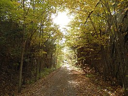
128:Cataraqui Trail east of Chaffey's Lock
113:
7:
944:
942:
887:
885:
958:. You can help Knowledge (XXG) by
905:. You can help Knowledge (XXG) by
821:Alexander MacKenzie Heritage Trail
540:Greenlink Rotary Park Trail System
14:
946:
889:
458:Bike and hiking trails in Canada
423:Frontenac Arch Biosphere Reserve
418:Cataraqui Trail official website
405:
313:Frontenac Arch Biosphere Reserve
122:
34:relies largely or entirely on a
23:
1040:Eastern Ontario geography stubs
477:International Appalachian Trail
331:, near kilometre post 42. The
831:Galloping Goose Regional Trail
274:designated as kilometre zero (
1:
1020:Transport in Frontenac County
270:, at a parking lot south of
545:Louisbourg Lighthouse Trail
137:104 kilometres (65 mi)
1066:
941:
901:geographical article is a
884:
682:La Cloche Silhouette Trail
836:Juan de Fuca Marine Trail
687:Laura Secord Legacy Trail
504:Newfoundland and Labrador
348:Canadian National Railway
121:
601:Nepisiguit Mi'gmaq Trail
364:List of trails in Canada
560:Wilkie Sugar Loaf trail
1005:Rail trails in Ontario
846:Vancouver Island Trail
722:Prescott-Russell Trail
707:North Simcoe Railtrail
535:Devils Hill Road Trail
517:Newfoundland T'Railway
866:Northwest Territories
757:West Toronto Railpath
555:Uisge Ban Falls Trail
550:Musquodoboit Trailway
293:44.89000°N 76.03056°W
195:, and with a permit:
874:Canol Heritage Trail
697:Martin Goodman Trail
570:Prince Edward Island
414:at Wikimedia Commons
189:cross-country skiing
47:improve this article
732:Spencer Creek Trail
629:P'tit Train du Nord
578:Confederation Trail
389:Glenburnie, Ontario
298:44.89000; -76.03056
289: /
1045:Canada trail stubs
1010:Trans Canada Trail
692:Leaside Spur Trail
677:K&P Rail Trail
493:Trans Canada Trail
471:Great Divide Trail
333:K&P Rail Trail
321:Trans Canada Trail
272:Ontario Highway 15
1050:Canada road stubs
967:
966:
914:
913:
882:
881:
841:North Coast Trail
747:The Crack (trail)
410:Media related to
252:
251:
112:
111:
97:
62:"Cataraqui Trail"
1057:
988:
981:
974:
950:
943:
935:
928:
921:
893:
886:
851:West Coast Trail
813:British Columbia
803:Waskahegan Trail
793:Iron Horse Trail
752:Waterfront Trail
712:Oak Ridges Trail
672:Iron Horse Trail
606:Sentier NB Trail
512:East Coast Trail
452:
445:
438:
429:
409:
393:
392:
380:
304:
303:
301:
300:
299:
294:
290:
287:
286:
285:
282:
185:horseback riding
126:
114:
107:
104:
98:
96:
55:
27:
19:
1065:
1064:
1060:
1059:
1058:
1056:
1055:
1054:
995:
994:
993:
992:
940:
939:
899:Eastern Ontario
883:
878:
860:
807:
779:
761:
667:Don Mills Trail
662:Cataraqui Trail
638:
610:
582:
564:
521:
498:
459:
456:
412:Cataraqui Trail
402:
397:
396:
385:Cataraqui Trail
382:
381:
377:
372:
360:
329:Chaffey's Locks
319:is part of the
297:
295:
291:
288:
283:
280:
278:
276:
275:
264:Eastern Ontario
256:Cataraqui Trail
227:Canadian Shield
161:
146:Eastern Ontario
129:
117:Cataraqui Trail
108:
102:
99:
56:
54:
40:
28:
17:
12:
11:
5:
1063:
1061:
1053:
1052:
1047:
1042:
1037:
1032:
1027:
1022:
1017:
1012:
1007:
997:
996:
991:
990:
983:
976:
968:
965:
964:
951:
938:
937:
930:
923:
915:
912:
911:
894:
880:
879:
877:
876:
870:
868:
862:
861:
859:
858:
853:
848:
843:
838:
833:
828:
826:Chilkoot Trail
823:
817:
815:
809:
808:
806:
805:
800:
795:
789:
787:
781:
780:
778:
777:
775:Wascana Trails
771:
769:
763:
762:
760:
759:
754:
749:
744:
739:
737:Spurline Trail
734:
729:
724:
719:
714:
709:
704:
699:
694:
689:
684:
679:
674:
669:
664:
659:
654:
652:Beltline Trail
648:
646:
640:
639:
637:
636:
631:
626:
620:
618:
612:
611:
609:
608:
603:
598:
596:Fundy Footpath
592:
590:
584:
583:
581:
580:
574:
572:
566:
565:
563:
562:
557:
552:
547:
542:
537:
531:
529:
523:
522:
520:
519:
514:
508:
506:
500:
499:
497:
496:
490:
483:Mantario Trail
480:
474:
467:
465:
464:Multi-province
461:
460:
457:
455:
454:
447:
440:
432:
426:
425:
420:
415:
401:
400:External links
398:
395:
394:
383:Anon. (2015).
374:
373:
371:
368:
367:
366:
359:
356:
250:
249:
236:
230:
229:
220:
216:
215:
212:
208:
207:
204:
200:
199:
170:
166:
165:
156:
150:
149:
143:
139:
138:
135:
131:
130:
127:
119:
118:
110:
109:
45:. Please help
31:
29:
22:
15:
13:
10:
9:
6:
4:
3:
2:
1062:
1051:
1048:
1046:
1043:
1041:
1038:
1036:
1033:
1031:
1028:
1026:
1023:
1021:
1018:
1016:
1013:
1011:
1008:
1006:
1003:
1002:
1000:
989:
984:
982:
977:
975:
970:
969:
963:
961:
957:
952:
949:
945:
936:
931:
929:
924:
922:
917:
916:
910:
908:
904:
900:
895:
892:
888:
875:
872:
871:
869:
867:
863:
857:
854:
852:
849:
847:
844:
842:
839:
837:
834:
832:
829:
827:
824:
822:
819:
818:
816:
814:
810:
804:
801:
799:
798:Skyline Trail
796:
794:
791:
790:
788:
786:
782:
776:
773:
772:
770:
768:
764:
758:
755:
753:
750:
748:
745:
743:
740:
738:
735:
733:
730:
728:
725:
723:
720:
718:
715:
713:
710:
708:
705:
703:
700:
698:
695:
693:
690:
688:
685:
683:
680:
678:
675:
673:
670:
668:
665:
663:
660:
658:
655:
653:
650:
649:
647:
645:
641:
635:
632:
630:
627:
625:
624:Cycloparc PPJ
622:
621:
619:
617:
613:
607:
604:
602:
599:
597:
594:
593:
591:
589:
588:New Brunswick
585:
579:
576:
575:
573:
571:
567:
561:
558:
556:
553:
551:
548:
546:
543:
541:
538:
536:
533:
532:
530:
528:
524:
518:
515:
513:
510:
509:
507:
505:
501:
494:
491:
488:
484:
481:
478:
475:
472:
469:
468:
466:
462:
453:
448:
446:
441:
439:
434:
433:
430:
424:
421:
419:
416:
413:
408:
404:
403:
399:
390:
386:
379:
376:
369:
365:
362:
361:
357:
355:
353:
349:
344:
342:
338:
334:
330:
326:
322:
318:
314:
311:
306:
302:
273:
269:
265:
261:
257:
248:
244:
240:
237:
235:
231:
228:
224:
221:
217:
213:
209:
205:
201:
198:
194:
190:
186:
182:
178:
174:
171:
167:
164:
160:
157:
155:
151:
147:
144:
140:
136:
132:
125:
120:
115:
106:
95:
92:
88:
85:
81:
78:
74:
71:
67:
64: –
63:
59:
58:Find sources:
52:
48:
44:
38:
37:
36:single source
32:This article
30:
26:
21:
20:
1015:Smiths Falls
960:expanding it
953:
907:expanding it
896:
767:Saskatchewan
727:Rideau Trail
661:
384:
378:
345:
337:Rideau Trail
325:Rideau Canal
307:
268:Smiths Falls
255:
253:
247:wild parsnip
223:Rideau Canal
197:snowmobiling
159:Smiths Falls
100:
90:
83:
76:
69:
57:
33:
742:The Bentway
717:Pan Am Path
657:Bruce Trail
634:Route Verte
527:Nova Scotia
317:Harrowsmith
296: /
193:snowshoeing
999:Categories
479:(NB/QC/NL)
370:References
341:Strathcona
284:76°01′50″W
281:44°53′24″N
260:rail trail
243:poison ivy
239:Mosquitoes
214:Year-round
203:Difficulty
163:Strathcona
154:Trailheads
103:March 2016
73:newspapers
43:talk page
856:Wildside
358:See also
148:, Canada
142:Location
785:Alberta
644:Ontario
473:(AB/BC)
387:(Map).
323:. The
234:Hazards
181:jogging
177:cycling
87:scholar
616:Quebec
310:UNESCO
219:Sights
211:Season
173:Hiking
134:Length
89:
82:
75:
68:
60:
897:This
495:(All)
94:JSTOR
80:books
956:stub
903:stub
489:/ON)
254:The
206:Easy
66:news
305:).
262:in
169:Use
49:by
1001::
487:MB
245:,
241:,
225:,
191:,
187:,
183:,
179:,
175:,
987:e
980:t
973:v
962:.
934:e
927:t
920:v
909:.
485:(
451:e
444:t
437:v
105:)
101:(
91:·
84:·
77:·
70:·
53:.
39:.
Text is available under the Creative Commons Attribution-ShareAlike License. Additional terms may apply.