282:
270:
48:
294:
742:
64:
907:
850:
71:
1002:
997:
281:
914:
831:
1007:
987:
585:
269:
618:
1037:
1027:
611:
967:
1012:
992:
604:
224:
rebellions in the New World took place on Saint John when
African slaves took over the island for six months. During the slave revolt, the farm was the headquarters of the Amina warriors.
1032:
63:
750:
643:
525:
456:
948:
1017:
972:
891:
99:
293:
47:
977:
315:
1022:
857:
726:
515:
477:
449:
202:
To reach
Catherineberg, turn north on John Head Road from Centerline Road. There is room for several cars to park right next to the windmill.
181:
941:
247:
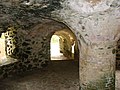
Catherineberg Sugar Mill Ruins are an example of an 18th-century sugar and rum factory. The documented ruins on the site are the windmill, a
627:
465:
348:
236:
232:
34:
884:
490:
442:
731:
596:
934:
773:
696:
631:
185:
758:
656:
533:
721:
686:
495:
372:"National Register of Historic Places Inventory/Nomination: Cathrineberg Jockumsdahl Herman Farm / Hammer Farm, Herman Farm"
741:
877:
676:
87:
691:
681:
635:
548:
500:
469:
228:
177:
139:
434:
716:
671:
510:
320:
794:
651:
568:
485:
982:
402:"National Register of Historic Places Inventory/Nomination: Virgin Islands National Park Multiple Resource Area"
906:
807:
666:
543:
1003:
Buildings and structures on the
National Register of Historic Places in the United States Virgin Islands
405:
375:
353:
783:
768:
310:
701:
553:
706:
505:
388:
711:
563:
918:
861:
401:
371:
144:
799:
214:
789:
558:
832:
National
Register of Historic Places listings in Saint John, United States Virgin Islands
217:
from the 18th to the 19th centuries, the farm eventually became land for grazing cattle.
157:
961:
429:
849:
998:
Agricultural buildings and structures on the
National Register of Historic Places
252:
586:
National
Register of Historic Places listings in Virgin Islands National Park
114:
101:
778:
915:
property in U.S. Virgin
Islands on the National Register of Historic Places
763:
231:. It is one of 17 properties in the park that were listed on the U.S.
196:
1008:
Historic
American Buildings Survey in the United States Virgin Islands
430:
National Park
Service: Catherineberg-Jockumsdahl-Herman Farm webpage.
988:
National
Register of Historic Places in Virgin Islands National Park
248:
227:
Today the sugar mill ruins are located in a protected area in the
221:
189:
343:
205:
The "most impressive" ruin is that of an unusual windmill tower.
600:
438:
193:
1038:
United States Virgin Islands Registered Historic Place stubs
255:, a stable and oxpound, and two unidentified structures.
922:
865:
70:
1028:
Windmills on the National Register of Historic Places
968:
Sugar plantations in Saint John, U.S. Virgin Islands
816:
749:
642:
524:
476:
163:
150:
138:
130:
93:
83:
1013:Buildings and structures in the Danish West Indies
993:Ruins on the National Register of Historic Places
263:Scenes around the Catherineberg Sugar Mill Site:
821:† This entry has been removed from the register.
188:. The ruins are an example of an 18th-century
942:
885:
732:Rustenberg Plantation South Historic District
612:
450:
8:
1033:United States Virgin Islands geography stubs
235:by 1981. The property was added to the U.S.
949:
935:
892:
878:
619:
605:
597:
457:
443:
435:
316:Sugar production in the Danish West Indies
46:
365:
363:
287:Interior view of including column details
35:U.S. National Register of Historic Places
858:Saint John, United States Virgin Islands
727:Reef Bay Sugar Factory Historic District
516:Reef Bay Sugar Factory Historic District
400:Frederik C. Gjessing (August 2, 1978).
332:
265:
1018:18th century in the Danish West Indies
722:Reef Bay Great House Historic District
687:Hermitage Plantation Historic District
657:Brown Bay Plantation Historic District
534:Brown Bay Plantation Historic District
496:Hermitage Plantation Historic District
370:Frederik C. Gjessing (February 1976).
344:"National Register Information System"
338:
336:
18:
973:Plantations in the Danish West Indies
662:Catherineberg-Jockumsdahl-Herman Farm
539:Catherineberg-Jockumsdahl-Herman Farm
220:In 1733 one of the first significant
27:Catherineberg-Jockumsdahl-Herman Farm
7:
903:
901:
846:
844:
707:Liever Marches Bay Historic District
628:National Register of Historic Places
506:Liever Marches Bay Historic District
466:National Register of Historic Places
349:National Register of Historic Places
237:National Register of Historic Places
233:National Register of Historic Places
176:is an historic site located in the
921:. You can help Knowledge (XXG) by
864:. You can help Knowledge (XXG) by
14:
978:Distilleries in the United States
275:Ruins, overgrown, unrestored area
905:
848:
774:Estate Carolina Sugar Plantation
759:Emmaus Moravian Church and Manse
740:
672:Congo Cay Archeological District
292:
280:
268:
145:Virgin Islands National Park MRA
69:
62:
1023:Saint John, U.S. Virgin Islands
677:Cruz Bay Town Historic District
389:seven photos from 1973 and 1976
186:Saint John, U.S. Virgin Islands
174:Catherineberg Sugar Mill Ruins
152:
52:Catherineberg Sugar Mill Ruins
1:
697:L'Esperance Historic District
88:Cruz Bay, U.S. Virgin Islands
692:Jossie Gut Historic District
682:Dennis Bay Historic District
636:United States Virgin Islands
549:Dennis Bay Historic District
501:Jossie Gut Historic District
470:Virgin Islands National Park
229:Virgin Islands National Park
178:Virgin Islands National Park
16:United States historic place
717:More Hill Historic District
511:More Hill Historic District
1054:
900:
843:
652:Annaberg Historic District
486:Annaberg Historic District
826:
738:
577:
321:Danish West Indies topics
151:NRHP reference
57:
45:
41:
32:
25:
21:
808:Trunk Bay Sugar Factory
667:Cinnamon Bay Plantation
544:Cinnamon Bay Plantation
860:location article is a
134:15 acres (6.1 ha)
913:This article about a
406:National Park Service
376:National Park Service
354:National Park Service
115:18.34667°N 64.76139°W
311:Estate Catherineberg
702:Lameshur Plantation
554:Lameshur Plantation
239:on March 30, 1978.
120:18.34667; -64.76139
111: /
478:Historic districts
930:
929:
873:
872:
838:
837:
769:Estate Beverhoudt
712:Mary Point Estate
594:
593:
564:Mary Point Estate
356:. April 15, 2008.
171:
170:
1045:
983:Sugar refineries
951:
944:
937:
909:
902:
894:
887:
880:
852:
845:
751:Other properties
744:
621:
614:
607:
598:
459:
452:
445:
436:
417:
416:
414:
412:
397:
391:
386:
384:
382:
367:
358:
357:
340:
296:
284:
272:
215:sugar plantation
154:
126:
125:
123:
122:
121:
116:
112:
109:
108:
107:
104:
73:
72:
66:
50:
19:
1053:
1052:
1048:
1047:
1046:
1044:
1043:
1042:
958:
957:
956:
955:
899:
898:
841:
839:
834:
822:
812:
795:Petroglyph Site
790:Lind Point Fort
745:
736:
638:
625:
595:
590:
573:
569:Petroglyph Site
559:Lind Point Fort
526:NRHP properties
520:
472:
463:
426:
421:
420:
410:
408:
399:
398:
394:
380:
378:
369:
368:
361:
342:
341:
334:
329:
307:
300:
297:
288:
285:
276:
273:
261:
251:, a factory, a
245:
211:
119:
117:
113:
110:
105:
102:
100:
98:
97:
79:
78:
77:
76:
75:
74:
53:
37:
28:
17:
12:
11:
5:
1051:
1049:
1041:
1040:
1035:
1030:
1025:
1020:
1015:
1010:
1005:
1000:
995:
990:
985:
980:
975:
970:
960:
959:
954:
953:
946:
939:
931:
928:
927:
910:
897:
896:
889:
882:
874:
871:
870:
853:
836:
835:
827:
824:
823:
820:
818:
814:
813:
811:
810:
805:
797:
792:
787:
781:
776:
771:
766:
761:
755:
753:
747:
746:
739:
737:
735:
734:
729:
724:
719:
714:
709:
704:
699:
694:
689:
684:
679:
674:
669:
664:
659:
654:
648:
646:
640:
639:
626:
624:
623:
616:
609:
601:
592:
591:
589:
588:
578:
575:
574:
572:
571:
566:
561:
556:
551:
546:
541:
536:
530:
528:
522:
521:
519:
518:
513:
508:
503:
498:
493:
488:
482:
480:
474:
473:
464:
462:
461:
454:
447:
439:
433:
432:
425:
424:External links
422:
419:
418:
392:
359:
331:
330:
328:
325:
324:
323:
318:
313:
306:
303:
302:
301:
298:
291:
289:
286:
279:
277:
274:
267:
260:
257:
244:
241:
210:
207:
169:
168:
167:March 30, 1978
165:
161:
160:
155:
148:
147:
142:
136:
135:
132:
128:
127:
95:
91:
90:
85:
81:
80:
68:
67:
61:
60:
59:
58:
55:
54:
51:
43:
42:
39:
38:
33:
30:
29:
26:
23:
22:
15:
13:
10:
9:
6:
4:
3:
2:
1050:
1039:
1036:
1034:
1031:
1029:
1026:
1024:
1021:
1019:
1016:
1014:
1011:
1009:
1006:
1004:
1001:
999:
996:
994:
991:
989:
986:
984:
981:
979:
976:
974:
971:
969:
966:
965:
963:
952:
947:
945:
940:
938:
933:
932:
926:
924:
920:
916:
911:
908:
904:
895:
890:
888:
883:
881:
876:
875:
869:
867:
863:
859:
854:
851:
847:
842:
833:
830:
825:
819:
815:
809:
806:
804:
803:
798:
796:
793:
791:
788:
785:
784:Keating's Inn
782:
780:
777:
775:
772:
770:
767:
765:
762:
760:
757:
756:
754:
752:
748:
743:
733:
730:
728:
725:
723:
720:
718:
715:
713:
710:
708:
705:
703:
700:
698:
695:
693:
690:
688:
685:
683:
680:
678:
675:
673:
670:
668:
665:
663:
660:
658:
655:
653:
650:
649:
647:
645:
641:
637:
633:
629:
622:
617:
615:
610:
608:
603:
602:
599:
587:
583:
580:
579:
576:
570:
567:
565:
562:
560:
557:
555:
552:
550:
547:
545:
542:
540:
537:
535:
532:
531:
529:
527:
523:
517:
514:
512:
509:
507:
504:
502:
499:
497:
494:
492:
491:Hassel Island
489:
487:
484:
483:
481:
479:
475:
471:
467:
460:
455:
453:
448:
446:
441:
440:
437:
431:
428:
427:
423:
407:
403:
396:
393:
390:
377:
373:
366:
364:
360:
355:
351:
350:
345:
339:
337:
333:
326:
322:
319:
317:
314:
312:
309:
308:
304:
299:Storage vault
295:
290:
283:
278:
271:
266:
264:
258:
256:
254:
250:
242:
240:
238:
234:
230:
225:
223:
218:
216:
208:
206:
203:
200:
198:
195:
191:
187:
183:
179:
175:
166:
164:Added to NRHP
162:
159:
156:
149:
146:
143:
141:
137:
133:
129:
124:
96:
92:
89:
86:
82:
65:
56:
49:
44:
40:
36:
31:
24:
20:
923:expanding it
912:
866:expanding it
855:
840:
828:
802:Santa Monica
801:
661:
581:
538:
409:. Retrieved
395:
379:. Retrieved
347:
262:
246:
243:Architecture
226:
219:
212:
204:
201:
173:
172:
84:Nearest city
381:January 10,
118: /
94:Coordinates
962:Categories
632:Saint John
411:January 9,
327:References
253:horse mill
180:, east of
106:64°45′41″W
103:18°20′48″N
829:See also:
817:Footnotes
779:Fortsberg
644:Districts
582:See also
305:See also
182:Cruz Bay
158:78000270
764:Enighed
259:Gallery
209:History
197:factory
917:is a
856:This
387:with
249:still
222:slave
190:sugar
919:stub
862:stub
800:HMS
413:2017
383:2017
192:and
131:Area
630:in
468:in
194:rum
184:on
153:No.
140:MPS
964::
634:,
584::
404:.
374:.
362:^
352:.
346:.
335:^
213:A
199:.
950:e
943:t
936:v
925:.
893:e
886:t
879:v
868:.
786:†
620:e
613:t
606:v
458:e
451:t
444:v
415:.
385:.
Text is available under the Creative Commons Attribution-ShareAlike License. Additional terms may apply.