29:
322:
336:
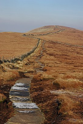
210:. The closest access is from Pym Chair car park, from where a public footpath, laid on large stone slabs, runs south across Cats Tor and continues south along the ridge to Shining Tor. A local legend tells that Pym Chair is the spot where a highway man called Pym robbed passers by on the packhorse route. Another story is that Pym was a preacher who gave sermons there.
359:
354:
645:
455:
518:
118:
655:
207:
543:
218:
349:
61:
28:
293:
112:
54:
225:
is the main plant but the heathland is habitat for a variety of native grasses, rushes, sedges and shrubs including
650:
397:
485:
289:
249:
are common along The Tors ridge. The area is important for upland breeding birds including a large population of
507:
447:
310:
Oldgate Nick, on the northern slope of Cats Tor, is a gritstone buttress with 15 graded rock climbing routes.
250:
206:
The moorland ridge on which Cats Tor lies is designated "Open Access" land for the public, following the
234:
242:
168:
192:
200:
341:
196:
569:
262:
222:
184:
422:
296:
aircraft were from the 2906th
Observation Group. The planes were on a training flight from
327:
258:
230:
131:
126:
238:
639:
615:
282:
188:
147:
270:
214:
159:
304:
176:
321:
300:. Both aircraft flew straight into the hillside in cloud in the mid-afternoon.
213:
The open gritstone moorlands of the Upper Goyt Valley (Wild Moor, Goyt's Moss,
317:
297:
278:
254:
155:
76:
63:
590:
180:
191:. On the west wide of the ridge, water drains into Todd Brook which feeds
266:
246:
226:
151:
101:
307:, used by the Derbyshire Soaring Club and the Peak Soaring Association.
477:
105:
163:
44:
274:
217:, Shining Tor to Cats Tor ridge and Hop Moor) are a designated
166:. The summit is 518 metres (1,699 ft) above sea level.
360:
List of Sites of
Special Scientific Interest in Derbyshire
423:"Tor definition and meaning | Collins English Dictionary"
292:
planes crashed on Cats Tor. Both pilots were killed. The
355:
List of Sites of
Special Scientific Interest in Cheshire
386:(Map). 1:25000. Explorer. Ordnance Survey. West sheet.
544:"P-47D 42-7872 & 42-7898, Cats Tor, Bollington"
125:
111:
97:
92:
53:
43:
38:
21:
172:is an Old English word for a high, rocky hill.
183:ridge. The ridge continues to the north past
8:
591:"Paragliding Club in the Peak District UK"
18:
646:Mountains and hills of the Peak District
179:is about 2 km south along The Tors
370:
208:Countryside and Rights of Way Act 2000
458:from the original on 4 September 2009
378:
376:
374:
7:
570:"Cats Tor – Derbyshire Soaring Club"
195:. East of Cats Tor are views of the
548:Peak District Air Accident Research
303:Cats Tor is a popular location for
219:Site of Special Scientific Interest
524:from the original on 12 April 2020
488:from the original on 10 April 2016
350:List of hills in the Peak District
14:
656:Mountains and hills of Derbyshire
334:
320:
27:
448:"CRoW and Coastal Access Maps"
1:
150:hill on the border between
672:
290:Republic P-47D Thunderbolt
49:518 metres (1,699 ft)
427:www.collinsdictionary.com
288:On 30 September 1943 two
26:
16:Hill in Cheshire, England
595:PEAK SOARING ASSOCIATION
243:Hare’s-tail cottongrass
187:and Taxal Edge towards
158:, between the towns of
33:Paved path to Cats Tor
398:"CATS TOR, HIGH PEAK"
384:OL24 White Peak area
517:. 31 January 1990.
193:Toddbrook Reservoir
175:The higher peak of
73: /
620:www.ukclimbing.com
508:"Goyt Valley SSSI"
482:Goyt Valley Online
239:cross-leaved heath
201:Fernilee Reservoir
199:, Foxlow Edge and
77:53.2801°N 2.0092°W
39:Highest point
651:Hills of Cheshire
342:Derbyshire portal
141:
140:
663:
631:
630:
628:
626:
612:
606:
605:
603:
601:
587:
581:
580:
578:
576:
566:
560:
559:
557:
555:
540:
534:
533:
531:
529:
523:
512:
504:
498:
497:
495:
493:
474:
468:
467:
465:
463:
444:
438:
437:
435:
433:
419:
413:
412:
410:
408:
394:
388:
387:
380:
344:
339:
338:
337:
330:
325:
324:
185:Windgather Rocks
121:
88:
87:
85:
84:
83:
82:53.2801; -2.0092
78:
74:
71:
70:
69:
66:
31:
19:
671:
670:
666:
665:
664:
662:
661:
660:
636:
635:
634:
624:
622:
614:
613:
609:
599:
597:
589:
588:
584:
574:
572:
568:
567:
563:
553:
551:
550:. 7 August 2016
542:
541:
537:
527:
525:
521:
515:Natural England
510:
506:
505:
501:
491:
489:
476:
475:
471:
461:
459:
452:Natural England
446:
445:
441:
431:
429:
421:
420:
416:
406:
404:
396:
395:
391:
382:
381:
372:
368:
340:
335:
333:
328:Cheshire portal
326:
319:
316:
117:
81:
79:
75:
72:
67:
64:
62:
60:
59:
34:
17:
12:
11:
5:
669:
667:
659:
658:
653:
648:
638:
637:
633:
632:
616:"Oldgate Nick"
607:
582:
561:
535:
499:
469:
439:
414:
389:
369:
367:
364:
363:
362:
357:
352:
346:
345:
331:
315:
312:
139:
138:
129:
123:
122:
115:
109:
108:
99:
95:
94:
90:
89:
57:
51:
50:
47:
41:
40:
36:
35:
32:
24:
23:
15:
13:
10:
9:
6:
4:
3:
2:
668:
657:
654:
652:
649:
647:
644:
643:
641:
621:
617:
611:
608:
596:
592:
586:
583:
571:
565:
562:
549:
545:
539:
536:
520:
516:
509:
503:
500:
487:
483:
479:
473:
470:
457:
453:
449:
443:
440:
428:
424:
418:
415:
403:
402:OS GetOutside
399:
393:
390:
385:
379:
377:
375:
371:
365:
361:
358:
356:
353:
351:
348:
347:
343:
332:
329:
323:
318:
313:
311:
308:
306:
301:
299:
295:
291:
286:
284:
280:
276:
272:
268:
264:
260:
256:
253:, as well as
252:
251:golden plover
248:
247:sphagnum moss
244:
240:
236:
232:
228:
224:
220:
216:
211:
209:
204:
202:
198:
194:
190:
189:Whaley Bridge
186:
182:
178:
173:
171:
170:
165:
161:
157:
153:
149:
148:Peak District
145:
136:
133:
130:
128:
124:
120:
116:
114:
110:
107:
103:
100:
96:
91:
86:
58:
56:
52:
48:
46:
42:
37:
30:
25:
20:
625:26 September
623:. Retrieved
619:
610:
600:26 September
598:. Retrieved
594:
585:
575:26 September
573:. Retrieved
564:
554:26 September
552:. Retrieved
547:
538:
526:. Retrieved
514:
502:
490:. Retrieved
481:
472:
460:. Retrieved
451:
442:
432:26 September
430:. Retrieved
426:
417:
407:26 September
405:. Retrieved
401:
392:
383:
309:
302:
287:
215:Burbage Edge
212:
205:
174:
167:
160:Macclesfield
143:
142:
134:
119:SJ 9948 7590
305:paragliding
197:Goyt Valley
177:Shining Tor
80: /
55:Coordinates
640:Categories
366:References
298:RAF Atcham
279:ring ouzel
255:red grouse
156:Derbyshire
65:53°16′48″N
478:"History"
231:crowberry
181:gritstone
93:Geography
68:2°00′33″W
45:Elevation
528:12 April
519:Archived
492:22 March
486:Archived
462:23 March
456:Archived
314:See also
267:whinchat
235:cowberry
227:bilberry
221:(SSSI).
152:Cheshire
144:Cats Tor
135:Explorer
127:Topo map
102:Cheshire
98:Location
22:Cats Tor
263:lapwing
223:Heather
113:OS grid
106:England
283:merlin
259:curlew
164:Buxton
522:(PDF)
511:(PDF)
294:USAAF
275:twite
271:snipe
146:is a
627:2020
602:2020
577:2020
556:2020
530:2020
494:2020
464:2020
434:2020
409:2020
281:and
245:and
237:and
162:and
154:and
137:OL24
169:Tor
642::
618:.
593:.
546:.
513:.
484:.
480:.
454:.
450:.
425:.
400:.
373:^
285:.
277:,
273:,
269:,
265:,
261:,
257:,
241:.
233:,
229:,
203:.
132:OS
104:,
629:.
604:.
579:.
558:.
532:.
496:.
466:.
436:.
411:.
Text is available under the Creative Commons Attribution-ShareAlike License. Additional terms may apply.