58:
769:
42:
436:
In the CDP, the population was spread out, with 27.2% under the age of 18, 9.9% from 18 to 24, 30.0% from 25 to 44, 24.7% from 45 to 64, and 8.2% who were 65 years of age or older. The median age was 35 years. For every 100 females, there were 97.1 males. For every 100 females age 18 and over, there
432:
living together, 11.5% had a female householder with no husband present, and 25.7% were non-families. 19.6% of all households were made up of individuals, and 7.0% had someone living alone who was 65 years of age or older. The average household size was 2.72 and the average family size was 3.11.
396:
of 2000, there were 1,703 people, 627 households, and 465 families residing in the CDP. The population density was 741.6 inhabitants per square mile (286.3/km). There were 657 housing units at an average density of 286.1 per square mile (110.5/km). The racial makeup of the CDP was 97.89%
57:
1197:
440:
The median income for a household in the CDP was $ 35,481, and the median income for a family was $ 43,214. Males had a median income of $ 40,160 versus $ 21,074 for females. The
662:
609:
561:
841:
831:
1202:
861:
856:
851:
836:
876:
41:
531:
871:
655:
253:
71:
1114:
648:
263:
587:
464:
302:
A post office called Cedar Hill has been in operation since 1868. The community was named for cedar trees near the elevated town site.
866:
318:, a four-lane highway, runs through the western side of the CDP, leading northeast into St. Louis and west 22 miles (35 km) to
846:
881:
826:
204:
640:
565:
402:
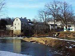
939:
406:
125:
904:
507:
414:
326:
803:
788:
753:
672:
539:
287:
130:
1134:
1074:
793:
371:
929:
279:
241:
103:
488:
1167:
1034:
891:
428:
There were 627 households, out of which 38.8% had children under the age of 18 living with them, 56.5% were
283:
32:
984:
1139:
974:
723:
418:
337:, forms the southern and western limits of the CDP, and the community is the site of an old mill and dam.
738:
718:
319:
1174:
1119:
1079:
944:
914:
422:
330:
214:
47:
1094:
1064:
1024:
954:
808:
748:
743:
694:
410:
398:
1149:
1144:
1029:
1004:
979:
924:
899:
798:
780:
1124:
1104:
1089:
1084:
1049:
1019:
999:
994:
964:
728:
603:
441:
315:
1109:
1059:
1044:
1039:
1014:
1009:
969:
934:
919:
758:
733:
713:
444:
for the CDP was $ 15,599. About 5.7% of families and 12.9% of the population were below the
1129:
1099:
1069:
1054:
989:
705:
1154:
818:
590:. The State Historical Society of Missouri. Archived from the original on June 24, 2016
1191:
532:"Geographic Identifiers: 2010 Census Summary File 1 (G001): Cedar Hill CDP, Missouri"
334:
246:
445:
687:
623:
489:
U.S. Geological Survey
Geographic Names Information System: Cedar Hill, Missouri
113:
86:
73:
329:, the CDP has a total area of 2.3 square miles (5.9 km), all land. The
311:
195:
448:, including 6.1% of those under age 18 and 8.8% of those age 65 or over.
429:
291:
229:
118:
768:
393:
310:
Cedar Hill is located 32 miles (51 km) southwest of downtown
221:
200:
644:
294:, United States. The population was 1,721 at the 2010 census.
767:
503:
1198:
Census-designated places in
Jefferson County, Missouri
588:"Jefferson County Place Names, 1928–1945 (archived)"
953:
890:
817:
779:
704:
262:
252:
240:
228:
211:
194:
186:
178:
173:
165:
157:
149:
141:
136:
124:
112:
102:
23:
18:Census-designated place in Missouri, United States
608:: CS1 maint: bot: original URL status unknown (
772:Map of Missouri highlighting Jefferson County
656:
526:
524:
8:
663:
649:
641:
564:. Jim Forte Postal History. Archived from
425:of any race were 0.82% of the population.
344:
20:
456:
333:, a northward-flowing tributary of the
251:
227:
193:
172:
164:
135:
101:
66:
54:
38:
601:
484:
482:
364:
498:
496:
261:
239:
210:
185:
177:
156:
148:
140:
123:
111:
7:
1203:Census-designated places in Missouri
538:. U.S. Census Bureau. Archived from
417:, and 0.70% from two or more races.
161:0.00 sq mi (0.00 km)
153:2.29 sq mi (5.94 km)
145:2.29 sq mi (5.94 km)
671:Municipalities and communities of
624:"Census of Population and Housing"
354:
14:
465:"ArcGIS REST Services Directory"
62:Location of Cedar Hill, Missouri
56:
40:
1:
467:. United States Census Bureau
190:816.99/sq mi (315.42/km)
508:United States Census Bureau
327:United States Census Bureau
1219:
674:Jefferson County, Missouri
1163:
765:
685:
385:
370:
363:
358:
353:
350:
67:
55:
39:
30:
280:unincorporated community
169:538 ft (164 m)
284:census-designated place
33:Census-designated place
773:
771:
504:"U.S. Census website"
386:U.S. Decennial Census
346:Historical population
213: • Summer (
87:38.35667°N 90.62222°W
1176:United States portal
542:on February 13, 2020
187: • Density
25:Cedar Hill, Missouri
940:Raintree Plantation
568:on October 19, 2016
536:American Factfinder
347:
286:(CDP) in northwest
92:38.35667; -90.62222
83: /
774:
345:
179: • Total
158: • Water
142: • Total
1185:
1184:
905:Briarwood Estates
442:per capita income
437:were 95.1 males.
390:
389:
325:According to the
316:Missouri Route 30
273:
272:
150: • Land
1210:
1177:
1170:
804:Peaceful Village
789:Cedar Hill Lakes
770:
754:Olympian Village
697:
690:
680:
675:
665:
658:
651:
642:
636:
635:
633:
631:
620:
614:
613:
607:
599:
597:
595:
584:
578:
577:
575:
573:
558:
552:
551:
549:
547:
528:
519:
518:
516:
514:
500:
491:
486:
477:
476:
474:
472:
461:
403:African American
366:
361:
356:
348:
288:Jefferson County
218:
98:
97:
95:
94:
93:
88:
84:
81:
80:
79:
76:
60:
44:
21:
1218:
1217:
1213:
1212:
1211:
1209:
1208:
1207:
1188:
1187:
1186:
1181:
1175:
1169:Missouri portal
1168:
1159:
1135:Sulphur Springs
1075:Meramec Heights
956:
949:
886:
813:
794:Lake Tekakwitha
775:
763:
700:
695:
688:
681:
678:
673:
669:
639:
629:
627:
622:
621:
617:
600:
593:
591:
586:
585:
581:
571:
569:
560:
559:
555:
545:
543:
530:
529:
522:
512:
510:
502:
501:
494:
487:
480:
470:
468:
463:
462:
458:
454:
430:married couples
407:Native American
359:
343:
308:
300:
236:
212:
91:
89:
85:
82:
77:
74:
72:
70:
69:
63:
51:
35:
26:
19:
12:
11:
5:
1216:
1214:
1206:
1205:
1200:
1190:
1189:
1183:
1182:
1180:
1179:
1172:
1164:
1161:
1160:
1158:
1157:
1152:
1147:
1142:
1137:
1132:
1127:
1122:
1117:
1112:
1107:
1102:
1097:
1092:
1087:
1082:
1077:
1072:
1067:
1062:
1057:
1052:
1047:
1042:
1037:
1032:
1027:
1022:
1017:
1012:
1007:
1002:
997:
992:
987:
982:
977:
972:
967:
961:
959:
951:
950:
948:
947:
942:
937:
932:
930:LaBarque Creek
927:
922:
917:
912:
907:
902:
896:
894:
888:
887:
885:
884:
879:
874:
869:
864:
859:
854:
849:
844:
839:
834:
829:
823:
821:
815:
814:
812:
811:
806:
801:
796:
791:
785:
783:
777:
776:
766:
764:
762:
761:
756:
751:
746:
741:
736:
731:
726:
721:
716:
710:
708:
702:
701:
686:
683:
682:
670:
668:
667:
660:
653:
645:
638:
637:
615:
579:
562:"Post Offices"
553:
520:
492:
478:
455:
453:
450:
388:
387:
383:
382:
379:
377:
374:
368:
367:
362:
357:
352:
342:
339:
307:
304:
299:
296:
271:
270:
267:
260:
259:
256:
250:
249:
244:
238:
237:
234:
232:
226:
225:
219:
209:
208:
198:
192:
191:
188:
184:
183:
180:
176:
175:
171:
170:
167:
163:
162:
159:
155:
154:
151:
147:
146:
143:
139:
138:
134:
133:
128:
122:
121:
116:
110:
109:
106:
100:
99:
65:
64:
61:
53:
52:
45:
37:
36:
31:
28:
27:
24:
17:
13:
10:
9:
6:
4:
3:
2:
1215:
1204:
1201:
1199:
1196:
1195:
1193:
1178:
1173:
1171:
1166:
1165:
1162:
1156:
1153:
1151:
1148:
1146:
1143:
1141:
1138:
1136:
1133:
1131:
1128:
1126:
1123:
1121:
1118:
1116:
1113:
1111:
1108:
1106:
1103:
1101:
1098:
1096:
1093:
1091:
1088:
1086:
1083:
1081:
1078:
1076:
1073:
1071:
1068:
1066:
1063:
1061:
1058:
1056:
1053:
1051:
1048:
1046:
1043:
1041:
1038:
1036:
1035:House Springs
1033:
1031:
1028:
1026:
1023:
1021:
1018:
1016:
1013:
1011:
1008:
1006:
1003:
1001:
998:
996:
993:
991:
988:
986:
983:
981:
978:
976:
973:
971:
968:
966:
963:
962:
960:
958:
952:
946:
943:
941:
938:
936:
933:
931:
928:
926:
923:
921:
918:
916:
913:
911:
908:
906:
903:
901:
898:
897:
895:
893:
889:
883:
880:
878:
875:
873:
870:
868:
865:
863:
860:
858:
855:
853:
850:
848:
845:
843:
840:
838:
835:
833:
830:
828:
825:
824:
822:
820:
816:
810:
807:
805:
802:
800:
797:
795:
792:
790:
787:
786:
784:
782:
778:
760:
757:
755:
752:
750:
747:
745:
742:
740:
737:
735:
732:
730:
727:
725:
722:
720:
717:
715:
712:
711:
709:
707:
703:
699:
698:
691:
684:
679:United States
676:
666:
661:
659:
654:
652:
647:
646:
643:
625:
619:
616:
611:
605:
589:
583:
580:
567:
563:
557:
554:
541:
537:
533:
527:
525:
521:
509:
505:
499:
497:
493:
490:
485:
483:
479:
466:
460:
457:
451:
449:
447:
443:
438:
434:
431:
426:
424:
420:
416:
413:, 0.35% from
412:
408:
404:
400:
395:
384:
380:
378:
375:
373:
369:
349:
340:
338:
336:
335:Meramec River
332:
328:
323:
321:
317:
313:
305:
303:
297:
295:
293:
289:
285:
281:
277:
268:
265:
257:
255:
248:
245:
243:
233:
231:
223:
220:
216:
206:
205:Central (CST)
202:
199:
197:
189:
181:
168:
160:
152:
144:
132:
129:
127:
120:
117:
115:
108:United States
107:
105:
96:
68:Coordinates:
59:
50:at Cedar Hill
49:
43:
34:
29:
22:
16:
1140:Valles Mines
975:Belews Creek
909:
724:Crystal City
693:
628:. Retrieved
626:. Census.gov
618:
592:. Retrieved
582:
570:. Retrieved
566:the original
556:
544:. Retrieved
540:the original
535:
511:. Retrieved
469:. Retrieved
459:
446:poverty line
439:
435:
427:
391:
341:Demographics
324:
309:
301:
275:
274:
15:
985:Byrnesville
957:communities
739:Herculaneum
719:Byrnes Mill
689:County seat
594:October 19,
572:October 18,
513:January 31,
415:other races
90: /
46:Dam on the
1192:Categories
1120:Rush Tower
1080:Morse Mill
945:Summer Set
915:High Ridge
910:Cedar Hill
867:River View
842:High Ridge
546:August 17,
471:August 28,
452:References
392:As of the
276:Cedar Hill
266:feature ID
174:Population
78:90°37′20″W
75:38°21′24″N
1115:Riverside
1095:Old Mines
1065:Mapaville
1025:Grubville
832:Big River
819:Townships
809:Scotsdale
749:Kimmswick
744:Hillsboro
696:Hillsboro
331:Big River
320:St. Clair
312:St. Louis
306:Geography
254:FIPS code
242:Area code
196:Time zone
166:Elevation
131:Jefferson
48:Big River
1150:Vineland
1145:Victoria
1030:Hematite
1005:Fletcher
980:Bushburg
925:Imperial
900:Barnhart
847:Imperial
799:Parkdale
781:Villages
604:cite web
419:Hispanic
409:, 0.18%
405:, 0.82%
401:, 0.06%
292:Missouri
258:29-12358
230:ZIP code
119:Missouri
1125:Seckman
1105:Plattin
1090:Oermann
1085:Munsons
1050:Liguori
1020:Goldman
1000:Donnell
995:Dittmer
965:Antonia
882:Windsor
862:Plattin
857:Meramec
852:Joachim
837:Central
729:De Soto
630:June 4,
298:History
269:2393369
104:Country
1110:Regina
1060:Ludwig
1045:Knorpp
1040:Jarvis
1015:Frumet
1010:Flucom
970:Bailey
935:Murphy
920:Horine
827:Arnold
759:Pevely
734:Festus
714:Arnold
706:Cities
423:Latino
394:census
351:Census
278:is an
126:County
1130:Selma
1100:Papin
1070:Melzo
1055:Local
990:Danby
955:Other
877:Valle
411:Asian
399:White
376:1,875
235:63016
224:(CDT)
222:UTC-5
201:UTC-6
182:1,875
114:State
1155:Ware
892:CDPs
872:Rock
632:2016
610:link
596:2016
574:2016
548:2018
515:2008
473:2022
372:2020
360:Note
355:Pop.
282:and
264:GNIS
137:Area
421:or
247:636
215:DST
1194::
692::
677:,
606:}}
602:{{
534:.
523:^
506:.
495:^
481:^
365:%±
322:.
314:.
290:,
664:e
657:t
650:v
634:.
612:)
598:.
576:.
550:.
517:.
475:.
381:—
217:)
207:)
203:(
Text is available under the Creative Commons Attribution-ShareAlike License. Additional terms may apply.