376:
337:
1009:
638:
154:
150:, was built in or around 1875. It was originally called the Highway to the top of East Rock. Charles Warren and Charles Blatchley developed the Road. Warren Place in the Cedar Hill was named after Charles Warren. The beginning of the street is now a residential area but the better part of it is now closed to cars but can be hiked up to the top of East Rock.
420:
199:, during the building of the new railyard in Cedar Hill rail men wanted to strike, but were able to get the extra pay to work all the hours the construction of the yard would require. Cedar Hill Yards had 14 yards of the 25 that were in New Haven at the time. The railyard could hold over 15,000 cars at a time. The trolleys were stored in what is now the
635:
17:
458:. The height on the rock's eastern side is 160 ft (49 m) and on the west side over 200 ft (61 m). The traprock covers the eastern slope, while the sandstone covers the western slope. At the south end of the rock, behind the property lines on the north side of Rock Street, at a junction of the trap and sandstone, the
242:
220:
Street. Mostly brick structures were popping up around the area. An excellent example would also be the John H. Slator
Building (built and owned by John Slator, President of the Masons at the time), a late 19th-century Italianate style detached duplex row house at 1515-1517 State Street. And is a registered historical home.
173:. Basserman's Rock Brewery on State Street. The brewery took its name from Snake Rock, an extension of East Rock. Basserman owned the brewery and the adjacent apartment building, which still stands on the corner of Rock and 1395 State Street. He sold the property in 1888 to John M. Manning of Buffalo, a brother of the late
162:
636:
http://images.lib.uconn.edu/cdm4/item_viewer.php?CISOROOT=%2Fcho&CISOPTR=16457&DMSCALE=100.00000&DMWIDTH=750&DMHEIGHT=807.121771218&DMMODE=viewer&DMFULL=0&DMOLDSCALE=2.05733&DMX=0&DMY=0&DMTEXT=%2520new%2520haven%2520map&DMTHUMB=1&REC=9&DMROTATE=0&x=104&y=43
1182:
443:
and Indian Head. The newly formed Parks
Commission constructed Indian Head Drive in 1890 which started at Bishops Gate (Mrs. John Bishop sold a good part of her land to the parks department, the land going down to Rock Road at the time) on State Street and over Snake Rock, Indian Head and to the top
108:
Prior to the mid-19th century, the Cedar Hill district remained one of the most undeveloped portions of New Haven. The earliest significant settlement of the district does not appear to have taken place until the mid or late 1840s. An 1851 map shows that only about a dozen scattered houses and shops
249:
This is a list of the original streets of Cedar Hill. When I-95 was built some were removed (marked as gone); see map. The importance of this is that the community is now isolated from its communities on all sides, stalling city services from getting to it. Three other communities in New Haven were
120:
also were born and lived in Cedar hill. Elias B. Bishop married the Major's daughter Grace (Grace Street in Cedar Hill is named after her; at one time it was the road around the bottom of East Rock and is now partly called Rock Street and
English Drive) and bought the Atwater House on State Street,
207:
The development of Cedar Hill continued at a gradual pace through the early years of the 20th century. Most of the residents of Cedar Hill Avenue at that time were there to help with the Ferry Street
Congregational Church work. Grace, May and Cedar Hill Avenues were laid out in the Reconstruction
219:
Although the economic character of Cedar Hill changed gradually, the architectural complexion of the area appears to have changed little since the late 1940s. The best remaining example of scattered commercial structures built in Cedar Hill is the
Michael W. Ferrell Building at 1296-1304 State
215:
The
National Folding Box & Paper Co. is on James Street across from the Cedar Hill Station (car barn when there were trolleys), and both buildings still stand today. City lines at the time defined this area as Cedar Hill. It was a large factory for its time, a four-story building over
95:
settlers recorded living in Cedar Hill (at that time called the East Farm). David
Atwater, who died October 5, 1692, was the first of the New Haven Colony who was sworn a freeman of the united colony. A farm was assigned to him in the "Neck", the tract between the Mill and
228:
Up until the 2002 Cedar Hill was part of the Fair Haven
District of New Haven. The community members in 2000 (based on the finds of the 2000 census) were asked to vote what district they wanted to be part of because of census results requiring New Haven to
125:
had lived in the area now known as View Street, but when it started becoming more populated he relocated. Charles A. Warren
President of the State Street House Railroad Company took over the property his office was at 82G Grand Street, Atwater building.
1162:
1748 Map of the city of New Haven and vicinity from actual surveys by
Hartley and Whiteford, surveyors. Shows buildings and property owners and includes views of local buildings. Also inset: a plan of the town of New Haven, with all the buildings in
216:
240,000 sq ft (22,000 m). Over 22,629 people were employed there. The Bridgeport branch had 23,343. This showed that Bridgeport was the largest manufacturing city in the State during this time, but New Haven was a close second.
370:
was extended to the new Cedar Hill yards. The widening required a new bridge at Ferry Street. The bridge was entirely paid for by the railroad with the exception of $ 316.92 paid by the city of New Haven for a temporary bridge during
365:
in the northeast part of New Haven, the Cedar Hill Terminal, in order to consolidate and expand its freight operations. In connection with that work, the railroad right-of-way was then further widened to accommodate more tracks, and
487:
who donated a significant amount (along with two others) to the building of the park. One of several vehicular entrances to East Rock Park, English Gate offers the longest, and the most scenic, drive to the summit of East
203:
Bus Terminal. The building still stands virtually unchanged from when it housed trolleys. Even though the railyards are now all but empty, they still are a dominant part of the central part of the Cedar Hill District.
1105:
On the Four Rocks of the New Haven Region, East Rock, West Rock, Pine Rock, and Mill Rock, in Illustration of the Features of Non-volcanic Igneous Ejections: With a Guide to Walks and Drives about New Haven
367:
771:
657:
Greenough, Jones & Co's New Directory of the Inhabitants, Institutions, Manufacturing Establishments, Business, Societies, Business Firms, Etc. Etc. in the City and Town of New Haven for ...
454:- The source of the stones used in the construction of Bishops Gate is a broad mass of trap measuring 900 ft (270 m) by 450 ft (140 m) in its two diameters lying encased in
143:
From the late 1860s through the 1890s most of the development was residential and concentrated it that portion of the area which lay near the junction of State Street and Middletown Avenue.
680:
1256:
1143:
525:
483:- Also locally sourced and built in 1890. It is located at the intersection of Rock and View Streets where they end and English Drive begins. It was named after Governor
116:
The few residents of the area during this period included M. Atwater, J. Matlby, R. Atwater and R. Augur. Major Lyman Atwater (Lyman Street was named after him) and son
1468:
1220:
992:
826:
356:, a regionally important bridge fabricator; and as part of the New Haven Railroad's extensive improvements to its freight facilities in Cedar Hill, New Haven, CT.
767:
180:
Until the late 19th century, Cedar Hill was an area of Hamden. When the railyards were built, it was incorporated into New Haven's Fair Haven neighborhood.
1203:
Interesting 1927 map of New Haven shows street car lines in New Haven (note a park called Scheutzen in Cedar Hill near were Bishops gate can be found now).
439:- The first road to the top of East Rock was called the Old Stewart's Road. It started near Rice Field in Cedar Hill, up to the summit via the dip between
973:
812:
The British Invasion of New Haven, Connecticut: Together with Some Account of Their Landing and Burning the Towns of Fairfield and Norwalk, July, 1779
196:
1249:
1122:
Genealogical Register of the Descendants in the Male Line of David Atwater, one of the original planters of New Haven, to the sixth generation, 1873
471:, its summit exposed, but with the western wall of sandstone still standing and overtopping the trap. The sandstone shows everywhere the effects of
230:
1265:
245:
Map of the missing streets from the construction of I-95 in the 1950s; also note the Cedar Hill Depot for the trolleys now housing the CT Transit
1202:
1161:
475:, and before industrial encroachments on the rock in the 19th century there was a prominence of columnar sandstone in the southwestern bluff.
109:
were standing in the area by that time. Virtually all of the buildings stood along or close to the area's two principal streets The Road to
1242:
853:
735:
177:. He had plans to enlarge it, before the fire. No exact date of its closing can be found but there is record of a fire in the 1930s.
672:
718:
522:
1429:
1207:
915:
701:
608:
188:
The most significant feature of the area's development during the first half of the 20th century was the construction of the
507:
1217:
1030:
989:
1172:
432:
375:
55:
trees that were once plentiful there in 1665. The area was divided from the local surroundings by the construction of
20:
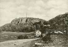
View of East Rock and Indian Head from Cedar Hill Area (now Rice Field), 1898. Note the cedar trees in the background.
1230:
East Rock Park Inside and Out (most recent study on Cedar Hill and surrounding communities of East Rock Park, page 20
423:
Bishop Gate - State Street Cedar Hill, New Haven, CT - First road to East Rock the trolley used to take people to it.
408:
1197:
208:
Era. These houses were constructed for the working men of the burgeoning manufacturing industries in the adjacent
1379:
1369:
1359:
591:
251:
48:
1339:
1309:
1288:
970:
110:
60:
40:
1229:
931:
209:
117:
1410:
1405:
1354:
1319:
1269:
1167:
655:
255:
92:
32:
169:
One of the more important light industry built in the area was the Rock Street Brewing Company, owned by
1400:
1334:
1293:
259:
444:
of East Rock. Bishops Gate has been closed off to motor vehicles due to falling rocks, but the two red
1208:
Aerial of New Haven 1934 pre-highway but after Rice field took down a half a dozen streets to be built
75:
town line, across to Middletown Avenue, to the Eastern side of State Street, back up to James Street.
1349:
1344:
1045:"Ferry Street Railroad Bridge, Ferry Street over New Haven Railroad, New Haven, New Haven County, CT"
484:
1324:
1071:
Charter and Ordinances of the City of New Haven: Together with Legislative Acts Affecting Said City
854:
http://ww25.kinglyheirs.com/AbandonedRR/CedarHill1.html?subid1=20230218-0038-534a-b290-7f9bf02ca223
396:
362:
353:
200:
72:
64:
233:, they became part of the East Rock district because of the shift of the congressional districts.
1415:
1374:
1329:
44:
1192:
113:(now known as upper State Street) and the Middletown Turnpike (now known as Middletown Avenue).
1212:
1168:
The above map shows Seat of Happiness, which hikers can find; take note of picture on this link
1148:
336:
1283:
1024:
867:
743:
404:
559:
History and antiquities of New Haven (Conn.) from its earliest settlement to the present time
523:
http://www.cityofnewhaven.com/CityPlan/pdfs/HistoricInventory/NH%20HRI%203%20Cedar%20Hill.pdf
170:
97:
1138:
579:. University of California Libraries. New Haven, Printed by Tuttle, Morehouse & Taylor.
1224:
996:
977:
880:
642:
529:
399:". West Hump was closed by the NH during the 1960s, but was briefly reopened in the early
395:
for refueling steam locomotives for the New York, New Haven and Hartford Railroad at the "
388:
189:
1086:
574:
557:
509:
Genealogical and Personal Memoirs Relating to the Families of the State of Massachusetts
1384:
990:
http://www.cityofnewhaven.com/CityPlan/pdfs/Maps/NeighborhoodPlanningMaps/East_Rock.pdf
459:
174:
147:
1128:
pages 6–9, written by the city of New Haven, found in the New Haven Historical Library
1462:
1103:
626:
The city of New Haven, Conn. 1879. Drawn & pub. by O. H. Bailey & J. C. Hazen
542:
392:
88:
28:
947:
793:
157:
Rock Street Brewery, Cedar Hill, New Haven, CT The Brewery burned down in the 1890s.
1364:
472:
400:
349:
52:
1193:
1911 maps of New Haven communities; Cedar Hill is on maps 23 and partial on map 19
1069:
810:
1177:
192:
in the central part of the district between State Street and Middletown Avenue.
36:
153:
1444:
1431:
1234:
747:
290:
May Street *Willow Street (turns into Blatchley right on the Cedar Hill Line)
1187:
1044:
971:
http://www.cityofnewhaven.com/CityPlan/pdfs/AnnualReports/AnnualReport02.pdf
623:
468:
455:
445:
440:
131:
122:
68:
56:
673:"Fair Haven Plan, Atlas: New Haven County 1868, Connecticut Historical Map"
1178:
1879 map of New Haven (can zoom in to see old streets and house placement)
448:
pillars still mark the start of a fantastic trail for biking and joggers.
419:
412:
16:
161:
348:
is significant as a representative example of standard 20th century
241:
59:
in the 1960s. Cedar Hill's boundary runs from James Street, up the
894:
418:
374:
335:
240:
160:
152:
15:
436:
1238:
660:
Greenough, Jones & Company, compilers and publishers. 1874.
39:. It includes portions of the city-designated neighborhoods of
435:
across from the old New York, New Haven and Hartford Railroad
933:
Benham's New Haven City Directory Also, the Annual Advertiser
1144:
Photos of Cedar Hill Rail Yard - Connecticut History Online
798:. New York Public Library. Meriden, Conn., Journal Pub. Co.
1126:
New Haven Resources Inventory Phase III Northern New Haven
165:
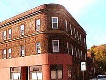
George Basserman apartment building at 1395 State Street
140:, was discovered in Cedar Hill by Dr. Eli Ives in 1779.
768:"Meriden Daily Republican - Google News Archive Search"
736:"New Haven, a City Of Beer Making (Until Prohibition)"
361:
Between 1910 and 1913, the railroad built a large new
1183:
1893 map with all the original streets of Cedar Hill
121:
Cedar Hill from the Major when he moved to Vermont.
1393:
1302:
1276:
999:
1990 map of East Rock District, Cedar Hill included
792:Atwater, Francis; Attwater, Charles Hobart (1901).
146:Rock Street, one of the gateway streets going into
706:. Kline Geology Laboratory, Yale University. 1818.
1218:2005 district map Cedar Hill is in East Rock Ward
610:Papers of the New Haven Colony Historical Society
593:Papers of the New Haven Colony Historical Society
546:, Journal Publishing Company, Meriden, Conn. 1907
1213:2002 Census Map Cedar Hill is in Fair Haven Ward
1173:1852 Map of Cedar Hill (with names of residents)
645:Map of where Henry Eld's house was in Cedar Hill
1074:. Press of the Price, Lee & Adkins Company.
1250:
948:"New Haven E. / (D.H. Hurd & Co.) / 1893"
607:Society, New Haven Colony Historical (1894).
590:Society, New Haven Colony Historical (1894).
8:
917:Public Documents of the State of Connecticut
827:"Sunday Herald - Google News Archive Search"
562:. Prelinger Library. New Haven, J.W. Barber.
1108:. Tuttle, Morehouse & Taylor, printers.
1257:
1243:
1235:
1012:. Archived from the original on 2012-02-24
403:era to relieve snow-related congestion at
195:Begun in 1909 as part of an effort by the
1151:. Cedar Hill is in the lower right corner
624:http://lcweb2.loc.gov/cgi-bin/map_item.pl
197:New York, New Haven and Hartford Railroad
809:Townshend, Charles Hervey (1879-01-01).
1469:Neighborhoods in New Haven, Connecticut
1188:1895 map of Connecticut Note-Cedar Hill
1139:New Haven Historical Digital collection
498:
340:Ferry Street truss bridge in Cedar Hill
1022:
876:
865:
512:. Lewis historical Publishing Company.
307:Some homes removed on State and Willow
7:
703:American Journal of Science and Arts
237:Cedar Hill streets, past and present
467:Snake Rock contains a half-emerged
231:redistrict before elections of 2002
1198:Cedar Hill Engine House facilities
14:
1149:Aerial photo of I-95 construction
1102:Dana, James Dwight (1891-01-01).
1088:East Rock Park at New Haven, Conn
1068:(Conn.), New Haven (1898-01-01).
1085:Wittemann, Adolph (1897-01-01).
936:. Price & Lee Company. 1899.
920:. order of the General Assembly.
734:Battista, Carolyn (1998-12-13).
576:Historical sketches of New Haven
506:Cutter, William Richard (1910).
980:City of New Haven Annual Report
774:from the original on 2022-09-05
683:from the original on 2016-03-04
573:Bartlett, Ellen Strong (1897).
352:construction; as a product of
1:
795:Atwater history and genealogy
543:Atwater History and Genealogy
556:Barber, John Warner (1831).
346:Ferry Street Railroad Bridge
293:a small part of James Street
815:. publisher not identified.
717:Haven (Conn.), New (1887).
297:Partially removed streets:
51:. Cedar Hill was named for
1485:
671:LLC., Historic Map Works.
411:. East Hump was closed by
287:Warren Street State Street
250:isolated in the same way:
1029:: CS1 maint: unfit URL (
677:www.historicmapworks.com
91:was one of the earliest
409:"Lindsay Storm of 1969"
118:Lyman Hotchkiss Atwater
424:
380:
341:
246:
166:
158:
136:, which is now called
21:
1445:41.32250°N 72.89500°W
422:
385:Cedar Hill Coal Tower
379:Cedar Hill Coal Tower
378:
339:
244:
164:
156:
138:Asclepias viridiflora
19:
914:Connecticut (1906).
851:ww25.kinglyheirs.com
485:James Edward English
1450:41.32250; -72.89500
1441: /
952:www.davidrumsey.com
720:Municipal Year Book
462:measures about 45°.
363:classification yard
354:Boston Bridge Works
201:Connecticut Transit
1416:Fair Haven Heights
1375:Quinnipiac Meadows
1223:2007-09-28 at the
995:2007-09-28 at the
976:2012-03-29 at the
895:"New Haven Museum"
740:The New York Times
641:2011-07-20 at the
528:2016-03-04 at the
425:
381:
342:
247:
167:
159:
45:Quinnipiac Meadows
22:
1424:
1423:
875:Missing or empty
540:Francis Atwater,
311:Streets removed:
301:Cedar Hill Avenue
265:Present streets:
98:Quinnipiac Rivers
1476:
1456:
1455:
1453:
1452:
1451:
1446:
1442:
1439:
1438:
1437:
1434:
1284:Amity-West Hills
1259:
1252:
1245:
1236:
1110:
1109:
1099:
1093:
1092:
1082:
1076:
1075:
1065:
1059:
1058:
1056:
1055:
1041:
1035:
1034:
1028:
1020:
1018:
1017:
1006:
1000:
987:
981:
968:
962:
961:
959:
958:
944:
938:
937:
928:
922:
921:
911:
905:
904:
902:
901:
891:
885:
884:
878:
873:
871:
863:
861:
860:
847:
841:
840:
838:
837:
823:
817:
816:
806:
800:
799:
789:
783:
782:
780:
779:
764:
758:
757:
755:
754:
731:
725:
724:
714:
708:
707:
698:
692:
691:
689:
688:
668:
662:
661:
652:
646:
633:
627:
621:
615:
614:
604:
598:
597:
587:
581:
580:
570:
564:
563:
553:
547:
538:
532:
520:
514:
513:
503:
258:and part of the
171:George Basserman
84:Early settlement
69:Indian Head Rock
1484:
1483:
1479:
1478:
1477:
1475:
1474:
1473:
1459:
1458:
1449:
1447:
1443:
1440:
1435:
1432:
1430:
1428:
1427:
1425:
1420:
1389:
1298:
1272:
1263:
1225:Wayback Machine
1158:
1156:For researchers
1135:
1119:
1114:
1113:
1101:
1100:
1096:
1091:. A. Wittemann.
1084:
1083:
1079:
1067:
1066:
1062:
1053:
1051:
1043:
1042:
1038:
1021:
1015:
1013:
1008:
1007:
1003:
997:Wayback Machine
988:
984:
978:Wayback Machine
969:
965:
956:
954:
946:
945:
941:
930:
929:
925:
913:
912:
908:
899:
897:
893:
892:
888:
874:
864:
858:
856:
849:
848:
844:
835:
833:
831:news.google.com
825:
824:
820:
808:
807:
803:
791:
790:
786:
777:
775:
766:
765:
761:
752:
750:
733:
732:
728:
716:
715:
711:
700:
699:
695:
686:
684:
670:
669:
665:
654:
653:
649:
643:Wayback Machine
634:
630:
622:
618:
606:
605:
601:
589:
588:
584:
572:
571:
567:
555:
554:
550:
539:
535:
530:Wayback Machine
521:
517:
505:
504:
500:
495:
389:Cedar Hill Yard
368:electrification
334:
318:Sycamore Street
239:
226:
190:Cedar Hill Yard
186:
106:
86:
81:
12:
11:
5:
1482:
1480:
1472:
1471:
1461:
1460:
1422:
1421:
1419:
1418:
1413:
1408:
1403:
1397:
1395:
1391:
1390:
1388:
1387:
1385:Wooster Square
1382:
1377:
1372:
1367:
1362:
1357:
1352:
1347:
1342:
1337:
1332:
1327:
1322:
1317:
1312:
1306:
1304:
1300:
1299:
1297:
1296:
1291:
1286:
1280:
1278:
1274:
1273:
1264:
1262:
1261:
1254:
1247:
1239:
1233:
1232:
1227:
1215:
1210:
1205:
1200:
1195:
1190:
1185:
1180:
1175:
1170:
1165:
1157:
1154:
1153:
1152:
1146:
1141:
1134:
1133:External links
1131:
1130:
1129:
1123:
1118:
1115:
1112:
1111:
1094:
1077:
1060:
1036:
1001:
982:
963:
939:
923:
906:
886:
842:
818:
801:
784:
759:
726:
709:
693:
663:
647:
628:
616:
599:
582:
565:
548:
533:
515:
497:
496:
494:
491:
490:
489:
477:
476:
464:
463:
449:
417:
416:
415:in April 1980.
373:
372:
358:
357:
333:
330:
329:
328:
325:
322:
319:
316:
315:Hemlock Street
309:
308:
305:
302:
295:
294:
291:
288:
285:
282:
279:
276:
273:
270:
238:
235:
225:
222:
212:neighborhood.
185:
182:
175:Daniel Manning
148:East Rock Park
105:
102:
85:
82:
80:
77:
13:
10:
9:
6:
4:
3:
2:
1481:
1470:
1467:
1466:
1464:
1457:
1454:
1417:
1414:
1412:
1409:
1407:
1404:
1402:
1399:
1398:
1396:
1392:
1386:
1383:
1381:
1378:
1376:
1373:
1371:
1370:Prospect Hill
1368:
1366:
1363:
1361:
1358:
1356:
1353:
1351:
1348:
1346:
1343:
1341:
1338:
1336:
1333:
1331:
1328:
1326:
1323:
1321:
1318:
1316:
1313:
1311:
1308:
1307:
1305:
1301:
1295:
1292:
1290:
1287:
1285:
1282:
1281:
1279:
1275:
1271:
1267:
1266:Neighborhoods
1260:
1255:
1253:
1248:
1246:
1241:
1240:
1237:
1231:
1228:
1226:
1222:
1219:
1216:
1214:
1211:
1209:
1206:
1204:
1201:
1199:
1196:
1194:
1191:
1189:
1186:
1184:
1181:
1179:
1176:
1174:
1171:
1169:
1166:
1164:
1160:
1159:
1155:
1150:
1147:
1145:
1142:
1140:
1137:
1136:
1132:
1127:
1124:
1121:
1120:
1116:
1107:
1106:
1098:
1095:
1090:
1089:
1081:
1078:
1073:
1072:
1064:
1061:
1050:
1046:
1040:
1037:
1032:
1026:
1011:
1005:
1002:
998:
994:
991:
986:
983:
979:
975:
972:
967:
964:
953:
949:
943:
940:
935:
934:
927:
924:
919:
918:
910:
907:
896:
890:
887:
882:
869:
855:
852:
846:
843:
832:
828:
822:
819:
814:
813:
805:
802:
797:
796:
788:
785:
773:
769:
763:
760:
749:
745:
741:
737:
730:
727:
722:
721:
713:
710:
705:
704:
697:
694:
682:
678:
674:
667:
664:
659:
658:
651:
648:
644:
640:
637:
632:
629:
625:
620:
617:
612:
611:
603:
600:
595:
594:
586:
583:
578:
577:
569:
566:
561:
560:
552:
549:
545:
544:
537:
534:
531:
527:
524:
519:
516:
511:
510:
502:
499:
492:
486:
482:
479:
478:
474:
470:
466:
465:
461:
457:
453:
450:
447:
442:
438:
434:
430:
427:
426:
421:
414:
410:
406:
402:
398:
394:
393:coaling tower
390:
386:
383:
382:
377:
371:construction.
369:
364:
360:
359:
355:
351:
347:
344:
343:
338:
331:
327:Grotto Street
326:
323:
320:
317:
314:
313:
312:
306:
303:
300:
299:
298:
292:
289:
286:
283:
280:
277:
275:Albert Street
274:
271:
269:Welton Street
268:
267:
266:
263:
261:
257:
253:
243:
236:
234:
232:
223:
221:
217:
213:
211:
205:
202:
198:
193:
191:
183:
181:
178:
176:
172:
163:
155:
151:
149:
144:
141:
139:
135:
133:
127:
124:
119:
114:
112:
103:
101:
99:
94:
90:
89:David Atwater
83:
78:
76:
74:
70:
66:
62:
58:
54:
50:
46:
42:
38:
34:
30:
26:
18:
1426:
1365:Newhallville
1314:
1310:Beaver Hills
1125:
1117:Bibliography
1104:
1097:
1087:
1080:
1070:
1063:
1052:. Retrieved
1048:
1039:
1014:. Retrieved
1004:
985:
966:
955:. Retrieved
951:
942:
932:
926:
916:
909:
898:. Retrieved
889:
877:|title=
857:. Retrieved
850:
845:
834:. Retrieved
830:
821:
811:
804:
794:
787:
776:. Retrieved
762:
751:. Retrieved
739:
729:
719:
712:
702:
696:
685:. Retrieved
676:
666:
656:
650:
631:
619:
609:
602:
592:
585:
575:
568:
558:
551:
541:
536:
518:
508:
501:
481:English Gate
480:
473:metamorphism
451:
433:State Street
428:
401:Penn Central
384:
345:
324:Birch Street
310:
296:
284:Ridge Street
278:Grace Street
272:Lyman Street
264:
248:
227:
224:Present time
218:
214:
206:
194:
187:
184:20th century
179:
168:
145:
142:
137:
130:
128:
115:
107:
104:19th century
87:
29:neighborhood
24:
23:
1448: /
1049:www.loc.gov
429:Bishop Gate
407:during the
405:Selkirk, NY
304:View Street
281:Rock Street
111:Wallingford
37:Connecticut
1436:72°53′42″W
1433:41°19′21″N
1411:Fair Haven
1406:East Shore
1380:West River
1360:Mill River
1355:Long Wharf
1320:City Point
1315:Cedar Hill
1054:2023-02-17
1016:2019-11-02
957:2023-02-17
900:2023-02-17
859:2023-02-17
836:2023-02-17
778:2016-09-20
753:2023-02-17
687:2016-04-12
493:References
452:Snake Rock
321:Ash Street
256:City Point
252:Mill River
210:Fair Haven
134:lanceolata
65:Rice Field
61:Mill River
49:Mill River
25:Cedar Hill
1401:The Annex
1340:East Rock
1294:Westville
1289:West Rock
1270:New Haven
748:0362-4331
469:laccolith
456:sandstone
441:East Rock
332:Landmarks
132:Asclepias
123:Henry Eld
71:, to the
41:East Rock
33:New Haven
1463:Category
1350:The Hill
1345:Edgewood
1330:Downtown
1221:Archived
1025:cite web
1010:"photos"
993:Archived
974:Archived
868:cite web
772:Archived
681:Archived
639:Archived
526:Archived
446:traprock
129:In 1818
93:European
1325:Dixwell
1303:Central
413:Conrail
387:in the
79:History
67:, over
1335:Dwight
746:
391:was a
73:Hamden
47:, and
1163:1748.
488:Rock.
431:- on
350:truss
260:Annex
63:, to
53:cedar
27:is a
1394:East
1277:West
1031:link
881:help
744:ISSN
437:YMCA
397:hump
57:I-91
1268:of
460:dip
31:in
1465::
1047:.
1027:}}
1023:{{
950:.
872::
870:}}
866:{{
829:.
770:.
742:.
738:.
679:.
675:.
262:.
254:,
100:.
43:,
35:,
1258:e
1251:t
1244:v
1057:.
1033:)
1019:.
960:.
903:.
883:)
879:(
862:.
839:.
781:.
756:.
723:.
690:.
613:.
596:.
Text is available under the Creative Commons Attribution-ShareAlike License. Additional terms may apply.