238:
49:
286:
29:
261:, on the north shore of the lake, serves as both a recreational trail and a link for non-motorized commuters to reach downtown Minneapolis. The 1.68-mile (2.70 km) shared-use path has three separate lanes, a pedestrian lane and east–west lanes for bicyclists and other wheeled users. Trails around the lake on the west include separate bicycle and pedestrian trails as do paths on the
56:
209:. The lake is surrounded by parkland, with some easements having been made to private homeowners on the southeast side; it is the only lake in the city with private shoreline. The south and west sides border the Cedar-Isles-Dean neighborhood, while the east shore flanks the
345:. Some fish consumption guideline restrictions have been placed on the lake's bluegill, carp, crappie, largemouth bass, northern pike, and walleye due to mercury and/or
100:
457:
472:
363:
48:
432:
226:
198:
462:
452:
358:
135:
467:
246:
225:
neighborhood. Cedar Lake has an area of 169 acres (0.68 km) and a maximum depth of 51 feet (16 m). The
383:
437:
222:
77:
274:
427:
400:
210:
34:
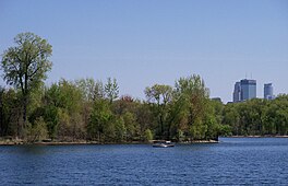
330:
254:
206:
262:
258:
214:
285:
318:
237:
28:
294:
142:
446:
410:
405:
322:
314:
298:
86:
342:
338:
250:
218:
202:
326:
190:
115:
102:
194:
81:
302:
334:
257:
on the south and east ends, respectively, via the parkway system. The
438:
U.S. Geological Survey
Geographic Names Information System: Cedar Lake
306:
284:
236:
346:
310:
186:
249:, connecting with Brownie Lake Park on the north end and
273:
There are three official swimming beaches at the lake,
201:. It is located on the west side of the city, north of
277:, Cedar Lake Point Beach, and Cedar Lake South Beach.
172:
164:
156:
152:
141:
131:
92:
73:
21:
265:, a short distance off the east side of the lake.
93:
229:manages the lake and parkland around the lake.
16:Lake in the state of Minnesota, United States
8:
18:
401:"Lake information report: Minnesota DNR"
386:. Minneapolis Park and Recreation Board.
197:, United States, and part of the city's
375:
364:List of shared-use paths in Minneapolis
395:
393:
213:residential area. On the north is the
428:Minnesota DNR Lake Information Report
227:Minneapolis Park and Recreation Board
37:skyline is visible in the background.
7:
458:Lakes of Hennepin County, Minnesota
55:
14:
54:
47:
27:
473:Shared-use paths in Minneapolis
171:
163:
155:
433:Minneapolis Parks – Cedar Lake
1:
72:
359:List of lakes in Minneapolis
241:Beach on Cedar Lake in 2012.
489:
245:Cedar Lake is part of the
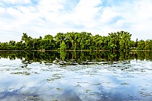
289:Cedar Lake in the Morning
247:Grand Rounds Scenic Byway
42:
26:
176:853 ft (260 m)
290:
242:
168:51 ft (16 m)
160:169 acres (68 ha)
288:
275:Cedar Lake East Beach
240:
116:44.96028°N 93.32111°W
463:Parks in Minneapolis
453:Lakes of Minneapolis
35:Downtown Minneapolis
33:Cedar Lake in 2012.
121:44.96028; -93.32111
112: /
468:Lakes of Minnesota
317:, hybrid sunfish,
293:The lake contains
291:
243:
331:tiger muskellunge
255:Lake of the Isles
207:Lake of the Isles
180:
179:
173:Surface elevation
480:
415:
414:
397:
388:
387:
380:
263:Kenilworth Trail
259:Cedar Lake Trail
221:, and the south
215:Cedar Lake Trail
127:
126:
124:
123:
122:
117:
113:
110:
109:
108:
105:
95:
58:
57:
51:
31:
19:
488:
487:
483:
482:
481:
479:
478:
477:
443:
442:
424:
419:
418:
399:
398:
391:
382:
381:
377:
372:
355:
349:contamination.
319:largemouth bass
283:
271:
235:
145: countries
120:
118:
114:
111:
106:
103:
101:
99:
98:
85:
69:
68:
67:
66:
65:
64:
63:
59:
38:
17:
12:
11:
5:
486:
484:
476:
475:
470:
465:
460:
455:
445:
444:
441:
440:
435:
430:
423:
422:External links
420:
417:
416:
389:
374:
373:
371:
368:
367:
366:
361:
354:
351:
295:black bullhead
282:
279:
270:
267:
234:
231:
199:Chain of Lakes
178:
177:
174:
170:
169:
166:
162:
161:
158:
154:
153:
150:
149:
146:
139:
138:
136:Chain of Lakes
133:
129:
128:
96:
90:
89:
75:
71:
70:
61:
60:
53:
52:
46:
45:
44:
43:
40:
39:
32:
24:
23:
15:
13:
10:
9:
6:
4:
3:
2:
485:
474:
471:
469:
466:
464:
461:
459:
456:
454:
451:
450:
448:
439:
436:
434:
431:
429:
426:
425:
421:
413:. 2005-07-11.
412:
408:
407:
402:
396:
394:
390:
385:
379:
376:
369:
365:
362:
360:
357:
356:
352:
350:
348:
344:
340:
336:
332:
328:
324:
323:northern pike
320:
316:
315:green sunfish
312:
308:
304:
300:
299:black crappie
296:
287:
280:
278:
276:
268:
266:
264:
260:
256:
252:
248:
239:
232:
230:
228:
224:
220:
216:
212:
208:
204:
200:
196:
192:
188:
184:
175:
167:
159:
151:
148:United States
147:
144:
140:
137:
134:
130:
125:
97:
91:
88:
87:United States
83:
79:
76:
50:
41:
36:
30:
25:
20:
404:
378:
343:yellow perch
339:white sucker
292:
272:
251:Bde Maka Ska
244:
219:BNSF Railway
205:and west of
203:Bde Maka Ska
182:
181:
157:Surface area
132:Part of
327:pumpkinseed
191:Minneapolis
119: /
107:093°19′16″W
94:Coordinates
78:Minneapolis
447:Categories
370:References
183:Cedar Lake
165:Max. depth
104:44°57′37″N
62:Cedar Lake
22:Cedar Lake
384:"Beaches"
223:Bryn Mawr
195:Minnesota
82:Minnesota
353:See also
303:bluegill
217:and the
74:Location
335:walleye
269:Beaches
211:Kenwood
411:MN DNR
406:MN DNR
341:, and
307:bowfin
233:Paths
185:is a
143:Basin
347:PFOS
311:carp
281:Fish
253:and
187:lake
189:in
449::
409:.
403:.
392:^
337:,
333:,
329:,
325:,
321:,
313:,
309:,
305:,
301:,
297:,
193:,
80:,
84:,
Text is available under the Creative Commons Attribution-ShareAlike License. Additional terms may apply.