29:
115:
122:
344:
258:
262:
188:. It is the first peak encountered while hiking the Black Mountain Crest Trail from Bowlens Creek. The trail passes to the southwest of the summit, which can be reached by various herd paths.
1258:
485:
372:
1268:
875:
796:
239:
1105:
867:
871:
740:
114:
851:
811:
786:
745:
365:
1114:
324:
1037:
687:
601:
831:
1263:
1248:
358:
1141:
906:
581:
381:
315:
197:
841:
781:
337:
1166:
821:
606:
449:
1047:
1027:
982:
421:
173:
1243:
1091:
943:
896:
891:
791:
776:
320:
71:
856:
692:
490:
243:
28:
1098:
771:
147:
1131:
434:
64:
901:
966:
181:
1253:
1052:
846:
654:
310:
515:
472:
185:
54:
1196:
533:
1002:
1211:
992:
886:
826:
626:
523:
389:
930:
816:
677:
338:
http://adventures.garmin.com/en-US/by/mepwoods/black-mountain-crest-trail-traverse-5-october-2013/
1083:
1072:
1012:
953:
881:
649:
1206:
1057:
1022:
1017:
997:
987:
961:
806:
710:
682:
480:
457:
1032:
702:
1176:
1161:
546:
495:
938:
916:
1186:
1181:
1136:
1126:
1007:
861:
761:
732:
659:
631:
596:
586:
566:
551:
439:
398:
177:
277:
1237:
1216:
1201:
1191:
1156:
1042:
801:
766:
641:
591:
576:
571:
1151:
911:
621:
556:
541:
505:
500:
1146:
1067:
836:
722:
669:
616:
343:
217:
1221:
1062:
611:
561:
462:
350:
86:
73:
411:
259:"Travel, Attractions and Points of Interest near Celo Knob, North Carolina"
715:
406:
292:
44:
1087:
354:
975:
952:
929:
754:
731:
701:
668:
640:
532:
514:
471:
448:
420:
397:
388:
159:
154:
143:
102:
63:
53:
43:
38:
21:
1259:Protected areas of Yancey County, North Carolina
866:Rich Mountain, near Boone, Watauga County - 1)
1115:The 20 highest major summits of North Carolina
1099:
366:
8:
1269:Mountains of Yancey County, North Carolina
1106:
1092:
1084:
394:
373:
359:
351:
33:Celo Knob viewed from Three Knobs Overlook
18:
746:North Carolina-Tennessee-Virginia Corners
342:
325:United States Department of the Interior
242:. The Nature Conservancy. Archived from
134:Location of Celo Knob in North Carolina.
486:Chestnut Mountain (Transylvania County)
278:"4372756 North Carolinas from the East"
209:
172:is the northernmost major peak in the
7:
16:Mountain in United States of America
797:Chestnut Mountain (Caldwell County)
316:Geographic Names Information System
261:. MountainPeaks.net. Archived from
198:List of mountains in North Carolina
14:
121:
120:
113:
27:
321:United States Geological Survey
180:. It is located just north of
150:, North Carolina, United States
1:
49:6,327 ft (1,928 m)
1264:Landmarks in North Carolina
1249:Mountains of North Carolina
382:Mountains of North Carolina
218:"Celo Knob, North Carolina"
1285:
1121:
182:Mount Mitchell State Park
107:
26:
1053:Standing Indian Mountain
847:Little Chestnut Mountain
655:North Eaglenest Mountain
59:647 ft (197 m)
1244:Pisgah National Forest
688:Little Yellow Mountain
516:Great Craggy Mountains
473:Great Balsam Mountains
348:
186:Pisgah National Forest
534:Great Smoky Mountains
346:
87:35.85222°N 82.24861°W
1212:Winter Star Mountain
1038:Occoneechee Mountain
993:Cane Creek Mountains
887:Spanish Oak Mountain
832:Grandmother Mountain
827:Grandfather Mountain
627:Thunderhead Mountain
524:Beaucatcher Mountain
390:Blue Ridge Mountains
931:Sauratown Mountains
817:Fire Scale Mountain
678:Big Yellow Mountain
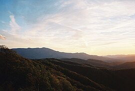
347:Celo Knob At Sunset
280:. Flickr. June 2008
92:35.85222; -82.24861
83: /
1073:Whiteside Mountain
1013:Looking Glass Rock
1003:Devil's Courthouse
954:Uwharrie Mountains
907:Three Top Mountain
882:Sassafras Mountain
876:Rich Mountain Bald
870:(SSW of Boone) 2)
650:Eaglenest Mountain
349:
39:Highest point
1231:
1230:
1207:Black Balsam Knob
1081:
1080:
1058:Terrells Mountain
1023:McAlpine Mountain
1018:Mayfield Mountain
998:Crowders Mountain
988:Big Butt Mountain
962:Caraway Mountains
925:
924:
874:(NW of Boone) 3)
842:Humpback Mountain
807:Doe Hill Mountain
782:Bluerock Mountain
711:Bob Stratton Bald
683:Grassy Ridge Bald
481:Black Balsam Knob
458:Hibriten Mountain
167:
166:
1276:
1108:
1101:
1094:
1085:
1033:Mulatto Mountain
822:Flattop Mountain
703:Unicoi Mountains
450:Brushy Mountains
395:
375:
368:
361:
352:
334:
332:
331:
306:
304:
303:
293:"SummitPost.org"
288:
286:
285:
273:
271:
270:
254:
252:
251:
240:"North Carolina"
226:
225:
214:
124:
123:
117:
98:
97:
95:
94:
93:
88:
84:
81:
80:
79:
76:
31:
19:
1284:
1283:
1279:
1278:
1277:
1275:
1274:
1273:
1254:Southern Sixers
1234:
1233:
1232:
1227:
1226:
1192:Mount Lyn Lowry
1177:Blackstock Knob
1162:Richland Balsam
1117:
1112:
1082:
1077:
1048:South Mountains
1028:Mount Jefferson
983:Albert Mountain
971:
967:Morrow Mountain
948:
921:
750:
727:
697:
664:
636:
547:Charlies Bunion
528:
510:
496:Richland Balsam
467:
444:
422:Black Mountains
416:
384:
379:
329:
327:
309:
301:
299:
291:
283:
281:
276:
268:
266:
257:
249:
247:
238:
235:
230:
229:
216:
215:
211:
206:
194:
174:Black Mountains
139:
138:
137:
136:
135:
132:
131:
130:
129:
125:
91:
89:
85:
82:
77:
74:
72:
70:
69:
34:
17:
12:
11:
5:
1282:
1280:
1272:
1271:
1266:
1261:
1256:
1251:
1246:
1236:
1235:
1229:
1228:
1225:
1224:
1219:
1214:
1209:
1204:
1199:
1194:
1189:
1187:Roan High Knob
1184:
1182:Waterrock Knob
1179:
1174:
1169:
1164:
1159:
1154:
1149:
1144:
1139:
1137:Clingmans Dome
1134:
1129:
1127:Mount Mitchell
1123:
1122:
1119:
1118:
1113:
1111:
1110:
1103:
1096:
1088:
1079:
1078:
1076:
1075:
1070:
1065:
1060:
1055:
1050:
1045:
1040:
1035:
1030:
1025:
1020:
1015:
1010:
1008:Kings Pinnacle
1005:
1000:
995:
990:
985:
979:
977:
973:
972:
970:
969:
964:
958:
956:
950:
949:
947:
946:
944:Pilot Mountain
941:
935:
933:
927:
926:
923:
922:
920:
919:
914:
909:
904:
899:
897:Sugar Mountain
894:
892:Stone Mountain
889:
884:
879:
878:(NNW of Boone)
864:
862:Pixie Mountain
859:
854:
849:
844:
839:
834:
829:
824:
819:
814:
809:
804:
799:
794:
792:Brown Mountain
789:
784:
779:
777:Beech Mountain
774:
769:
764:
762:Adams Mountain
758:
756:
752:
751:
749:
748:
743:
741:Snake Mountain
737:
735:
733:Iron Mountains
729:
728:
726:
725:
719:
718:
713:
707:
705:
699:
698:
696:
695:
690:
685:
680:
674:
672:
666:
665:
663:
662:
660:Waterrock Knob
657:
652:
646:
644:
638:
637:
635:
634:
632:Tricorner Knob
629:
624:
619:
614:
609:
604:
602:Mount Sterling
599:
597:Mount Sequoyah
594:
589:
587:Mount Hardison
584:
579:
574:
569:
567:Mount Cammerer
564:
559:
554:
552:Clingmans Dome
549:
544:
538:
536:
530:
529:
527:
526:
520:
518:
512:
511:
509:
508:
503:
498:
493:
488:
483:
477:
475:
469:
468:
466:
465:
460:
454:
452:
446:
445:
443:
442:
440:Mount Mitchell
437:
432:
426:
424:
418:
417:
415:
414:
409:
403:
401:
399:Bald Mountains
392:
386:
385:
380:
378:
377:
370:
363:
355:
341:
340:
335:
307:
297:SummitPost.org
289:
274:
255:
234:
233:External links
231:
228:
227:
222:Peakbagger.com
208:
207:
205:
202:
201:
200:
193:
190:
178:North Carolina
165:
164:
161:
157:
156:
152:
151:
145:
141:
140:
133:
127:
126:
119:
118:
112:
111:
110:
109:
108:
105:
104:
100:
99:
67:
61:
60:
57:
51:
50:
47:
41:
40:
36:
35:
32:
24:
23:
15:
13:
10:
9:
6:
4:
3:
2:
1281:
1270:
1267:
1265:
1262:
1260:
1257:
1255:
1252:
1250:
1247:
1245:
1242:
1241:
1239:
1223:
1220:
1218:
1217:Mount Collins
1215:
1213:
1210:
1208:
1205:
1203:
1202:Mount Kephart
1200:
1198:
1195:
1193:
1190:
1188:
1185:
1183:
1180:
1178:
1175:
1173:
1170:
1168:
1165:
1163:
1160:
1158:
1157:Mount Chapman
1155:
1153:
1150:
1148:
1145:
1143:
1140:
1138:
1135:
1133:
1130:
1128:
1125:
1124:
1120:
1116:
1109:
1104:
1102:
1097:
1095:
1090:
1089:
1086:
1074:
1071:
1069:
1066:
1064:
1061:
1059:
1056:
1054:
1051:
1049:
1046:
1044:
1043:Old Butt Knob
1041:
1039:
1036:
1034:
1031:
1029:
1026:
1024:
1021:
1019:
1016:
1014:
1011:
1009:
1006:
1004:
1001:
999:
996:
994:
991:
989:
986:
984:
981:
980:
978:
974:
968:
965:
963:
960:
959:
957:
955:
951:
945:
942:
940:
937:
936:
934:
932:
928:
918:
915:
913:
910:
908:
905:
903:
900:
898:
895:
893:
890:
888:
885:
883:
880:
877:
873:
872:Rich Mountain
869:
868:Rich Mountain
865:
863:
860:
858:
857:Peak Mountain
855:
853:
850:
848:
845:
843:
840:
838:
835:
833:
830:
828:
825:
823:
820:
818:
815:
813:
810:
808:
805:
803:
802:Crossing Knob
800:
798:
795:
793:
790:
788:
785:
783:
780:
778:
775:
773:
770:
768:
765:
763:
760:
759:
757:
753:
747:
744:
742:
739:
738:
736:
734:
730:
724:
721:
720:
717:
714:
712:
709:
708:
706:
704:
700:
694:
693:Roan Mountain
691:
689:
686:
684:
681:
679:
676:
675:
673:
671:
667:
661:
658:
656:
653:
651:
648:
647:
645:
643:
642:Plott Balsams
639:
633:
630:
628:
625:
623:
620:
618:
615:
613:
610:
608:
605:
603:
600:
598:
595:
593:
592:Mount Kephart
590:
588:
585:
583:
580:
578:
577:Mount Collins
575:
573:
572:Mount Chapman
570:
568:
565:
563:
560:
558:
555:
553:
550:
548:
545:
543:
540:
539:
537:
535:
531:
525:
522:
521:
519:
517:
513:
507:
504:
502:
499:
497:
494:
492:
491:Cold Mountain
489:
487:
484:
482:
479:
478:
476:
474:
470:
464:
461:
459:
456:
455:
453:
451:
447:
441:
438:
436:
433:
431:
428:
427:
425:
423:
419:
413:
410:
408:
405:
404:
402:
400:
396:
393:
391:
387:
383:
376:
371:
369:
364:
362:
357:
356:
353:
345:
339:
336:
326:
322:
318:
317:
312:
308:
298:
294:
290:
279:
275:
265:on 2011-07-19
264:
260:
256:
246:on 2008-10-06
245:
241:
237:
236:
232:
224:. 2008-07-08.
223:
219:
213:
210:
203:
199:
196:
195:
191:
189:
187:
183:
179:
175:
171:
162:
158:
153:
149:
146:
142:
116:
106:
101:
96:
68:
66:
62:
58:
56:
52:
48:
46:
42:
37:
30:
25:
20:
1171:
1152:Mount Gibbes
939:Moore's Knob
917:Woody's Knob
912:Tomkins Knob
852:Mount Pisgah
772:Bee Mountain
622:Spence Field
557:Gregory Bald
542:Andrews Bald
506:Tanasee Bald
501:Shining Rock
429:
328:. Retrieved
314:
300:. Retrieved
296:
282:. Retrieved
267:. Retrieved
263:the original
248:. Retrieved
244:the original
221:
212:
169:
168:
1197:Luftee Knob
1147:Balsam Cone
1142:Mount Guyot
1132:Mount Craig
1068:Wesser Bald
837:Howard Knob
723:Hooper Bald
670:Unaka Range
617:Silers Bald
582:Mount Guyot
435:Mount Craig
311:"Celo Knob"
176:of western
90: /
65:Coordinates
1238:Categories
1222:Marks Knob
1063:Wayah Bald
902:Table Rock
787:Brier Knob
767:Bear's Paw
612:Shuckstack
562:Marks Knob
463:Pores Knob
330:2011-05-09
302:2011-05-09
284:2011-05-09
269:2011-05-09
250:2011-05-09
204:References
78:82°14′55″W
75:35°51′08″N
55:Prominence
1172:Celo Knob
1167:Old Black
607:Old Black
430:Celo Knob
412:Max Patch
170:Celo Knob
128:Celo Knob
103:Geography
45:Elevation
22:Celo Knob
812:Elk Knob
716:Haw Knob
407:Big Bald
192:See also
155:Climbing
144:Location
184:in the
976:Others
755:Others
160:Access
148:Yancey
163:Hike
1240::
323:,
319:.
313:.
295:.
220:.
1107:e
1100:t
1093:v
374:e
367:t
360:v
333:.
305:.
287:.
272:.
253:.
Text is available under the Creative Commons Attribution-ShareAlike License. Additional terms may apply.