75:
899:
100:
58:
911:
443:
888:
245:
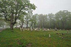
walls at one time had wooden fencing mounted on them, but this has been removed. Movement within the cemetery is via a turf cart path that skirts its perimeter, just inside the line of trees, and a series of paths laid out in a grid. Most of the over 600 stones are marble, with most of the rest made of granite. Many of the granite markers are made from stone quarried in nearby
353:
107:
82:
232:. The 2.4-acre (0.97 ha) cemetery was established c. 1774 (the date of its earliest marker), and continues to be used today. Its burials include many of the founders and early settlers of Worthington, and of families influential in the growth and development of the town. The cemetery listed on the
244:
Worthington's Center
Cemetery is located southwest of the town center, on the south side of Sam Hill Road. The roughly rectangular plot is set off from its surroundings by a stone wall on three sides, with a line of mature sugar maples just inside the walls, and running along the fourth side. The
256:
The oldest stones are in the lowest, westernmost portion of the cemetery. In these sections, stones are laid out without any sort of family grouping. These are more often seen beginning in the 19th century, with bounded family plot areas found near the cemetery's highest land. The area that was
526:
834:
829:
824:
457:
946:
936:
522:
502:
497:
492:
462:
278:
512:
482:
384:
517:
507:
487:
467:
856:
477:
472:
861:
809:
689:
643:
576:
249:, and a number of them bear the marks of locally known stone carvers. One marker, that of Jerome Kinne (d. 1777) has an example of a "Hampton Indian", a motif resembling a Native American face, that is rarely found outside the
739:
714:
674:
602:
571:
550:
819:
755:
724:
679:
664:
659:
814:
719:
709:
612:
729:
704:
694:
669:
622:
607:
597:
581:
555:
765:
760:
734:
699:
684:
627:
617:
377:
961:
791:
786:
891:
393:
370:
781:
941:
866:
432:
422:
357:
871:
956:
20:
903:
272:
74:
417:
140:
99:
306:
233:
44:
951:
229:
128:
362:
412:
427:
407:
311:
246:
915:
250:
266:
57:
209:
930:
279:
National
Register of Historic Places listings in Hampshire County, Massachusetts
328:
155:
142:
442:
352:
947:
National
Register of Historic Places in Hampshire County, Massachusetts
937:
Cemeteries on the
National Register of Historic Places in Massachusetts
257:
the last developed is decorated in part with ornamental plantings.
301:
366:
228:
is a historic cemetery on the south side of Sam Hill Road in
394:
U.S. National
Register of Historic Places in Massachusetts
962:
1774 establishments in the
Province of Massachusetts Bay
849:
802:
774:
748:
652:
636:
590:
564:
543:
536:
450:
423:
History of the
National Register of Historic Places
400:
215:
202:
194:
179:
171:
134:
123:
16:Historic cemetery in Massachusetts, United States
904:National Register of Historic Places portal
942:Cemeteries in Hampshire County, Massachusetts
378:
8:
358:Center Cemetery (Worthington, Massachusetts)
21:Center Cemetery (Southampton, Massachusetts)
273:North Cemetery (Worthington, Massachusetts)
540:
385:
371:
363:
56:
45:U.S. National Register of Historic Places
290:
106:
81:
323:
321:
302:"National Register Information System"
296:
294:
28:
329:"NRHP nomination for Center Cemetery"
19:For the cemetery in Southampton, see
7:
307:National Register of Historic Places
234:National Register of Historic Places
957:Cemeteries established in the 1770s
14:
909:
897:
887:
886:
441:
351:
105:
98:
80:
73:
331:. Commonwealth of Massachusetts
204:
1:
114:Show map of the United States
26:United States historic place
867:National Historic Landmarks
978:
952:Worthington, Massachusetts
862:Cape Cod National Seashore
230:Worthington, Massachusetts
129:Worthington, Massachusetts
18:
882:
439:
203:NRHP reference
89:Show map of Massachusetts
67:
55:
51:
42:
35:
31:
916:United States portal
175:2.4 acres (0.97 ha)
240:Description and history
62:Center Cemetery in 2014
413:Keeper of the Register
428:National Park Service
408:Contributing property
360:at Wikimedia Commons
312:National Park Service
156:42.39444°N 72.94333°W
251:Hampton, Connecticut
161:42.39444; -72.94333
152: /
267:Ringville Cemetery
924:
923:
845:
844:
544:Barnstable County
418:Historic district
356:Media related to
314:. April 15, 2008.
223:
222:
219:February 26, 2004
969:
914:
913:
912:
902:
901:
900:
890:
889:
803:Worcester County
653:Middlesex County
541:
445:
387:
380:
373:
364:
355:
340:
339:
337:
336:
325:
316:
315:
298:
269:, Witt Hill Road
206:
190:
188:
167:
166:
164:
163:
162:
157:
153:
150:
149:
148:
145:
115:
109:
108:
102:
90:
84:
83:
77:
60:
29:
977:
976:
972:
971:
970:
968:
967:
966:
927:
926:
925:
920:
910:
908:
898:
896:
878:
841:
798:
770:
744:
648:
632:
586:
560:
532:
451:Lists by county
446:
437:
396:
391:
349:
344:
343:
334:
332:
327:
326:
319:
300:
299:
292:
287:
263:
242:
226:Center Cemetery
186:
184:
160:
158:
154:
151:
146:
143:
141:
139:
138:
119:
118:
117:
116:
113:
112:
111:
110:
93:
92:
91:
88:
87:
86:
85:
63:
47:
38:
37:Center Cemetery
27:
24:
17:
12:
11:
5:
975:
973:
965:
964:
959:
954:
949:
944:
939:
929:
928:
922:
921:
919:
918:
906:
894:
883:
880:
879:
877:
876:
875:
874:
864:
859:
853:
851:
847:
846:
843:
842:
840:
839:
838:
837:
832:
827:
817:
812:
806:
804:
800:
799:
797:
796:
795:
794:
789:
778:
776:
775:Suffolk County
772:
771:
769:
768:
763:
758:
752:
750:
749:Norfolk County
746:
745:
743:
742:
737:
732:
727:
722:
717:
712:
707:
702:
697:
692:
687:
682:
677:
672:
667:
662:
656:
654:
650:
649:
647:
646:
640:
638:
637:Hampden County
634:
633:
631:
630:
625:
620:
615:
610:
605:
600:
594:
592:
588:
587:
585:
584:
579:
574:
568:
566:
565:Bristol County
562:
561:
559:
558:
553:
547:
545:
538:
534:
533:
531:
530:
520:
515:
510:
505:
500:
495:
490:
485:
480:
475:
470:
465:
460:
454:
452:
448:
447:
440:
438:
436:
435:
433:Property types
430:
425:
420:
415:
410:
404:
402:
398:
397:
392:
390:
389:
382:
375:
367:
348:
347:External links
345:
342:
341:
317:
289:
288:
286:
283:
282:
281:
276:
270:
262:
259:
241:
238:
221:
220:
217:
213:
212:
207:
200:
199:
196:
192:
191:
181:
177:
176:
173:
169:
168:
136:
132:
131:
127:Sam Hill Rd.,
125:
121:
120:
104:
103:
97:
96:
95:
94:
79:
78:
72:
71:
70:
69:
68:
65:
64:
61:
53:
52:
49:
48:
43:
40:
39:
36:
33:
32:
25:
15:
13:
10:
9:
6:
4:
3:
2:
974:
963:
960:
958:
955:
953:
950:
948:
945:
943:
940:
938:
935:
934:
932:
917:
907:
905:
895:
893:
885:
884:
881:
873:
870:
869:
868:
865:
863:
860:
858:
855:
854:
852:
848:
836:
833:
831:
828:
826:
823:
822:
821:
818:
816:
813:
811:
808:
807:
805:
801:
793:
790:
788:
785:
784:
783:
780:
779:
777:
773:
767:
764:
762:
759:
757:
754:
753:
751:
747:
741:
738:
736:
733:
731:
728:
726:
723:
721:
718:
716:
713:
711:
708:
706:
703:
701:
698:
696:
693:
691:
688:
686:
683:
681:
678:
676:
673:
671:
668:
666:
663:
661:
658:
657:
655:
651:
645:
642:
641:
639:
635:
629:
626:
624:
621:
619:
616:
614:
611:
609:
606:
604:
601:
599:
596:
595:
593:
589:
583:
580:
578:
575:
573:
570:
569:
567:
563:
557:
554:
552:
549:
548:
546:
542:
539:
537:Lists by city
535:
528:
524:
521:
519:
516:
514:
511:
509:
506:
504:
501:
499:
496:
494:
491:
489:
486:
484:
481:
479:
476:
474:
471:
469:
466:
464:
461:
459:
456:
455:
453:
449:
444:
434:
431:
429:
426:
424:
421:
419:
416:
414:
411:
409:
406:
405:
403:
399:
395:
388:
383:
381:
376:
374:
369:
368:
365:
361:
359:
354:
346:
330:
324:
322:
318:
313:
309:
308:
303:
297:
295:
291:
284:
280:
277:
275:, Cold Street
274:
271:
268:
265:
264:
260:
258:
254:
252:
248:
239:
237:
235:
231:
227:
218:
216:Added to NRHP
214:
211:
208:
201:
197:
193:
182:
178:
174:
170:
165:
137:
133:
130:
126:
122:
101:
76:
66:
59:
54:
50:
46:
41:
34:
30:
22:
835:southwestern
830:northwestern
591:Essex County
350:
333:. Retrieved
305:
255:
243:
225:
224:
850:Other lists
810:Southbridge
690:Marlborough
644:Springfield
577:New Bedford
159: /
135:Coordinates
931:Categories
740:Winchester
715:Somerville
675:Framingham
603:Gloucester
572:Fall River
551:Barnstable
458:Barnstable
335:2013-12-16
285:References
198:G. Fleming
147:72°56′36″W
144:42°23′40″N
820:Worcester
756:Brookline
725:Wakefield
680:Lexington
665:Cambridge
660:Arlington
523:Worcester
503:Nantucket
498:Middlesex
493:Hampshire
463:Berkshire
236:in 2004.
195:Architect
892:Category
815:Uxbridge
792:southern
787:northern
720:Stoneham
710:Sherborn
613:Lawrence
527:northern
513:Plymouth
483:Franklin
261:See also
210:04000084
124:Location
857:Bridges
825:eastern
730:Waltham
705:Reading
695:Medford
670:Concord
623:Methuen
608:Ipswich
598:Andover
582:Taunton
556:Harwich
518:Suffolk
508:Norfolk
488:Hampden
468:Bristol
185: (
183:c. 1774
872:Boston
782:Boston
766:Quincy
761:Milton
735:Weston
700:Newton
685:Lowell
401:Topics
253:area.
247:Goshen
628:Salem
478:Essex
473:Dukes
180:Built
618:Lynn
187:1774
172:Area
205:No.
933::
320:^
310:.
304:.
293:^
529:)
525:(
386:e
379:t
372:v
338:.
189:)
23:.
Text is available under the Creative Commons Attribution-ShareAlike License. Additional terms may apply.