59:
115:
517:
275:
A productive combination of fertile low-lying agricultural land and significant deposits of economically valuable coal and iron have led to the
Central Lowlands being much more densely populated than the rest of Scotland. The cities of
389:
474:
458:
28:
435:
313:
562:
547:
542:
552:
94:
to the south. The
Central Lowlands are one of the three main geographical sub-divisions of Scotland, the other two being the
401:
507:
567:
557:
572:
343:
301:
20:
431:
193:
87:
169:
period some 300 million years ago. This area is relatively low-lying, although even here hills such as the
252:
91:
455:
146:
95:
537:
318:
126:
114:
58:
423:
221:
177:
are rarely far from view. In common with the rest of
Scotland the whole region was affected by
323:
256:
209:
397:
154:
130:
99:
521:
462:
293:
225:
245:
241:
217:
531:
237:
197:
174:
166:
201:
102:, which lie south of the associated second fault line. It is the most populated of
285:
205:
178:
170:
83:
229:
213:
181:
43:
30:
19:
This article is about the geographic region in
Scotland. For other uses, see
281:
264:
158:
123:
248:. This earlier vertical movement was later replaced by a horizontal shear.
78:, is a geologically defined area of relatively low-lying land in southern
16:
Geologically defined area of relatively low-lying land in southern
Scotland
289:
233:
142:
138:
103:
79:
277:
162:
150:
297:
260:
236:
periods (520 to 400 million years ago), during the closure of the
113:
57:
500:
Land of
Mountain and Flood: The Geology and Landforms of Scotland
342:
Christopher
Dingwall; Peter McGowan Associates; Ironside Farrar.
134:
240:. The fault allowed the Midland Valley to descend as a major
149:
are to be found. This area has also experienced intense
498:
McKirdy, Alan Gordon, John & Crofts, Roger (2007)
505:
244:
by as much as 4000 metres and there was subsequently
133:have economic significance for it is here that the
465:Gazetteer for Scotland. Retrieved 11 January 2008.
300:all lie in the Central Lowlands, and over 75% of
477:Scottishgeology.com. Retrieved 21 March 2008.
263:on the east coast 30 miles (50 km) from
122:The Central Lowlands is largely underlain by
8:
351:Clyde and Avon Valley Landscape Partnership
62:The main geographical divisions of Scotland
475:"Regional Geology, Southern Uplands - Map"
98:which lie to the north, northwest and the
400:and others. 20 July 2006. Archived from
161:being the remnant of a once much larger
512:
390:"Loch Lomond - Highland Boundary Fault"
334:
208:, then forms the northern boundary of
7:
228:collision which took place from Mid
436:Royal Scottish Geographical Society
196:runs from North Glen Sannox on the
486:Geology and landscapes of Scotland
200:in the south and west through the
14:
493:Collins Encyclopaedia of Scotland
314:Central Scotland (disambiguation)
515:
491:Keay, J. & Keay, J. (1994)
106:’s three geographical regions.
488:. Harpenden. Terra Publishing.
344:"Historical Development Study"
1:
589:
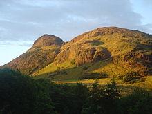
118:Arthur's Seat in Edinburgh
18:
424:"Highland Boundary Fault"
110:Geology and geomorphology
495:. London. HarperCollins.
456:"Southern Uplands Fault"
21:Lowland (disambiguation)
563:Highland Boundary Fault
548:Carboniferous volcanism
432:University of Edinburgh
216:in the north east. The
194:Highland Boundary Fault
88:Highland Boundary Fault
70:, sometimes called the
543:Carboniferous Scotland
428:Gazetteer for Scotland
304:lives in this region.
253:Southern Uplands Fault
220:was active during the
119:
92:Southern Uplands Fault
63:
553:Depressions of Europe
502:. Edinburgh. Birlinn.
302:Scotland's population
147:Industrial Revolution
117:
96:Highlands and Islands
90:to the north and the
61:
259:in the west towards
568:Regions of Scotland
558:Geology of Scotland
484:Gillen, Con (2003)
319:Geology of Scotland
82:. It consists of a
40: /
461:2005-12-19 at the
379:Keay (1994) p.420.
370:Gillen (2003) p.17
222:Caledonian orogeny
139:iron bearing rocks
120:
64:
573:Rifts and grabens
324:Scottish Lowlands
257:Rhins of Galloway
246:vertical movement
131:sedimentary rocks
580:
520:
519:
518:
511:
478:
472:
466:
453:
447:
446:
444:
442:
420:
414:
413:
411:
409:
398:Hunterian Museum
394:Scottish Geology
386:
380:
377:
371:
368:
362:
361:
359:
357:
348:
339:
212:before reaching
129:. Many of these
100:Southern Uplands
68:Central Lowlands
55:
54:
52:
51:
50:
45:
44:56.408°N 4.044°W
41:
38:
37:
36:
33:
588:
587:
583:
582:
581:
579:
578:
577:
528:
527:
526:
516:
514:
506:
481:
473:
469:
463:Wayback Machine
454:
450:
440:
438:
422:
421:
417:
407:
405:
388:
387:
383:
378:
374:
369:
365:
355:
353:
346:
341:
340:
336:
332:
310:
273:
271:Human geography
190:
188:Boundary faults
112:
48:
46:
42:
39:
34:
31:
29:
27:
26:
24:
17:
12:
11:
5:
586:
584:
576:
575:
570:
565:
560:
555:
550:
545:
540:
530:
529:
525:
524:
504:
503:
496:
489:
480:
479:
467:
448:
415:
404:on 18 May 2011
381:
372:
363:
333:
331:
328:
327:
326:
321:
316:
309:
306:
272:
269:
255:runs from the
226:plate tectonic
189:
186:
165:active in the
111:
108:
76:Central Valley
72:Midland Valley
49:56.408; -4.044
15:
13:
10:
9:
6:
4:
3:
2:
585:
574:
571:
569:
566:
564:
561:
559:
556:
554:
551:
549:
546:
544:
541:
539:
536:
535:
533:
523:
513:
509:
501:
497:
494:
490:
487:
483:
482:
476:
471:
468:
464:
460:
457:
452:
449:
437:
433:
429:
425:
419:
416:
403:
399:
395:
391:
385:
382:
376:
373:
367:
364:
352:
345:
338:
335:
329:
325:
322:
320:
317:
315:
312:
311:
307:
305:
303:
299:
295:
291:
287:
283:
279:
270:
268:
266:
262:
258:
254:
249:
247:
243:
239:
238:Iapetus Ocean
235:
231:
227:
223:
219:
215:
211:
207:
203:
199:
198:Isle of Arran
195:
187:
185:
183:
180:
176:
175:Campsie Fells
172:
168:
167:Carboniferous
164:
160:
156:
155:Arthur's Seat
152:
148:
144:
140:
136:
132:
128:
125:
116:
109:
107:
105:
101:
97:
93:
89:
85:
81:
77:
73:
69:
60:
56:
53:
22:
499:
492:
485:
470:
451:
439:. Retrieved
427:
418:
406:. Retrieved
402:the original
393:
384:
375:
366:
354:. Retrieved
350:
337:
274:
250:
202:Isle of Bute
191:
141:that fueled
121:
86:between the
75:
71:
67:
65:
25:
441:13 December
408:13 December
286:Dunfermline
206:Helensburgh
182:glaciations
179:Pleistocene
84:rift valley
47: /
538:Aulacogens
532:Categories
330:References
230:Ordovician
214:Stonehaven
210:Strathmore
127:formations
32:56°24′29″N
282:Edinburgh
265:Edinburgh
159:Edinburgh
151:volcanism
124:Paleozoic
35:4°02′38″W
522:Scotland
459:Archived
308:See also
290:Stirling
234:Devonian
143:Scotland
104:Scotland
80:Scotland
356:1 April
278:Glasgow
232:to Mid
163:volcano
508:Portal
298:Dundee
261:Dunbar
171:Ochils
347:(PDF)
294:Perth
224:, a
218:fault
443:2006
434:and
410:2006
358:2020
296:and
251:The
242:rift
204:and
192:The
173:and
137:and
135:coal
66:The
157:in
145:'s
74:or
534::
430:.
426:.
396:.
392:.
349:.
292:,
288:,
284:,
280:,
267:.
184:.
153:,
510::
445:.
412:.
360:.
23:.
Text is available under the Creative Commons Attribution-ShareAlike License. Additional terms may apply.