32:
90:
360:
87:
The centre of Canada can be measured in many ways. The most readily understood would be by taking the mid-point of the extremities of the
Canadian landmass section, above. The resulting location
393:
266:
215:
388:
365:
355:
52:
292:
315:
305:
491:
421:
350:
325:
235:
496:
345:
300:
284:
252:
259:
444:
411:
465:
330:
150:
219:
178:
174:
449:
79:
The intersection of these two lines is one definition of the centre point of Canada, as explained by the
375:
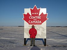
40:
470:
275:
158:
145:
68:
67:
centre of Canada (including islands, but excluding Canada's claim to the North Pole) is a line at
434:
31:
80:
439:
320:
35:
Sign on the Trans-Canada
Highway near Winnipeg, marking the longitude centre of Canada
485:
128:
239:
310:
197:
136:
106:
92:
55:
on the east and west, including islands (including
Newfoundland since 1949).
335:
48:
340:
177:
of Canada (the point furthest from any coastline or land border) is near
64:
44:
429:
244:
132:
162:
51:
centre of Canada; in effect, the north-south line midway between the
181:
at 34-115-17-W4 (Latitude: 59°1′ 48" N, Longitude: 112°49′ 12" W).
30:
248:
216:"The Atlas of Canada - Frequently Asked Questions About Canada"
118:
62 degrees 24 minutes North, 96 degrees 28 minutes West
236:
The centre of controversy: Where is Canada's middle?
458:
420:
404:
374:
291:
157:The nearest inhabited places to this point are
85:
260:
8:
267:
253:
245:
19:There are several ways of determining the
189:
75:Intersection of latitude and longitude
7:
14:
218:. 22 January 2013. Archived from
43:at 96°48'35"W (slightly east of
1:
23:giving different locations.
513:
282:
127:is located just south of
151:Natural Resources Canada
53:extreme points of Canada
179:Jackfish River, Alberta
175:pole of inaccessibility
169:Pole of inaccessibility
161:well to the north, and
39:There is a sign on the
155:
36:
47:) proclaiming it the
34:
492:Geographical centres
276:Geographical centres
41:Trans-Canada Highway
497:Geography of Canada
159:Baker Lake, Nunavut
146:The Atlas of Canada
102: /
16:Geographical center
198:"Center Of Canada"
71:24 minutes North.
37:
479:
478:
107:62.400°N 96.467°W
504:
269:
262:
255:
246:
224:
223:
212:
206:
205:
194:
153:
126:
125:
123:
122:
121:
119:
114:
113:
108:
103:
100:
99:
98:
95:
21:centre of Canada
512:
511:
507:
506:
505:
503:
502:
501:
482:
481:
480:
475:
454:
416:
400:
370:
287:
278:
273:
232:
227:
214:
213:
209:
196:
195:
191:
187:
171:
154:
143:
117:
115:
112:62.400; -96.467
111:
109:
105:
104:
101:
96:
93:
91:
89:
88:
81:Atlas of Canada
77:
61:
29:
17:
12:
11:
5:
510:
508:
500:
499:
494:
484:
483:
477:
476:
474:
473:
468:
462:
460:
456:
455:
453:
452:
447:
442:
437:
432:
426:
424:
418:
417:
415:
414:
408:
406:
402:
401:
399:
398:
397:
396:
386:
380:
378:
372:
371:
369:
368:
366:United Kingdom
363:
358:
353:
348:
343:
338:
333:
328:
323:
318:
313:
308:
303:
297:
295:
289:
288:
283:
280:
279:
274:
272:
271:
264:
257:
249:
243:
242:
231:
230:External links
228:
226:
225:
222:on 2013-01-22.
207:
188:
186:
183:
170:
167:
141:
76:
73:
60:
57:
28:
25:
15:
13:
10:
9:
6:
4:
3:
2:
509:
498:
495:
493:
490:
489:
487:
472:
469:
467:
464:
463:
461:
457:
451:
448:
446:
443:
441:
438:
436:
433:
431:
428:
427:
425:
423:
419:
413:
410:
409:
407:
403:
395:
392:
391:
390:
389:United States
387:
385:
382:
381:
379:
377:
376:North America
373:
367:
364:
362:
359:
357:
354:
352:
349:
347:
344:
342:
339:
337:
334:
332:
329:
327:
324:
322:
319:
317:
314:
312:
309:
307:
304:
302:
299:
298:
296:
294:
290:
286:
281:
277:
270:
265:
263:
258:
256:
251:
250:
247:
241:
237:
234:
233:
229:
221:
217:
211:
208:
203:
202:wikimapia.org
199:
193:
190:
184:
182:
180:
176:
168:
166:
165:to the east.
164:
160:
152:
148:
147:
140:
138:
134:
130:
129:Yathkyed Lake
124:
84:
82:
74:
72:
70:
66:
58:
56:
54:
50:
46:
42:
33:
26:
24:
22:
383:
220:the original
210:
201:
192:
172:
156:
144:
86:
83:'s website:
78:
62:
49:longitudinal
38:
20:
18:
471:New Zealand
356:Switzerland
110: /
65:latitudinal
486:Categories
185:References
137:Hudson Bay
135:, west of
116: (
69:62 degrees
466:Australia
440:Sri Lanka
321:Lithuania
240:Maclean's
149:website,
27:Longitude
394:by state
346:Slovenia
142:—
97:096°28′W
59:Latitude
45:Winnipeg
459:Oceania
361:Ukraine
316:Ireland
311:Hungary
306:Belgium
301:Belarus
133:Nunavut
94:62°24′N
450:Koreas
445:Taiwan
412:Uganda
405:Africa
384:Canada
351:Sweden
341:Serbia
336:Russia
331:Poland
326:Norway
293:Europe
163:Arviat
430:India
285:Earth
435:Iran
422:Asia
173:The
63:The
131:in
488::
238:-
200:.
268:e
261:t
254:v
204:.
139:.
120:)
Text is available under the Creative Commons Attribution-ShareAlike License. Additional terms may apply.