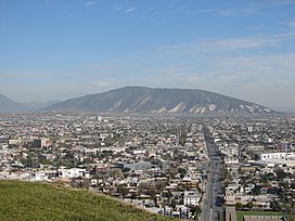
Cerro del Topo Chico
Source 📝
138:
131:
61:
188:
278:). The mountain is about 7.5 km long, is a symbol of Escobedo and San Nicolás, and is completely surrounded by Monterrey metropolitan area. It is known for being the source of the
384:
355:
130:
21:
429:
424:
419:
255:
167:
311:
392:
363:
306:
271:
267:
219:
86:
207:
275:
301:
296:
291:
331:
251:
235:
163:
112:
247:
200:
60:
413:
263:
175:
279:
36:
23:
259:
171:
243:
193:
76:
332:"Áreas Naturales Protegidas del estado de Nuevo León"
218:
213:
199:
181:
159:
118:
108:
100:
95:
85:
75:
70:
53:
8:
137:
50:
323:
385:"Nuevo León-San Nicolás de los Garza"
7:
238:, 'Small Mole Hill', from the Latin
65:Cerro del Topo Chico seen from south
266:, Mexico. The summit reaches 1,178
14:
186:
136:
129:
59:
16:Mountain in Nuevo León, Mexico
1:
356:"Nuevo León-General Escobedo"
81:1,178 m (3,865 ft)
270:, and it has 618 meters of
446:
91:618 m (2,028 ft)
262:municipalities; state of
123:
58:
430:Landforms of Nuevo León
425:Landmarks in Monterrey
307:Cerro de la Loma Larga
268:meters above sea level
37:25.77333°N 100.34972°W
208:Sierra Madre Oriental
232:Cerro del Topo Chico
144:Cerro del Topo Chico
54:Cerro del Topo Chico
42:25.77333; -100.34972
420:Mountains of Mexico
389:siglo.inafed.gob.mx
360:siglo.inafed.gob.mx
276:Cerro de las Mitras
101:English translation
33: /
302:Cerro del Obispado
297:Cerro de Chipinque
150:Location in Mexico
71:Highest point
292:Cerro de la Silla
228:
227:
437:
404:
403:
401:
400:
391:. Archived from
381:
375:
374:
372:
371:
362:. Archived from
352:
346:
345:
343:
342:
328:
203:
192:
190:
189:
140:
139:
133:
109:Language of name
63:
51:
48:
47:
45:
44:
43:
38:
34:
31:
30:
29:
26:
445:
444:
440:
439:
438:
436:
435:
434:
410:
409:
408:
407:
398:
396:
383:
382:
378:
369:
367:
354:
353:
349:
340:
338:
330:
329:
325:
320:
288:
282:mineral water.
201:
187:
185:
155:
154:
153:
152:
151:
148:
147:
146:
145:
141:
104:Little molehill
66:
41:
39:
35:
32:
27:
24:
22:
20:
19:
17:
12:
11:
5:
443:
441:
433:
432:
427:
422:
412:
411:
406:
405:
376:
347:
322:
321:
319:
316:
315:
314:
309:
304:
299:
294:
287:
284:
248:protected area
226:
225:
222:
216:
215:
211:
210:
205:
197:
196:
183:
179:
178:
161:
157:
156:
149:
143:
142:
135:
134:
128:
127:
126:
125:
124:
121:
120:
116:
115:
110:
106:
105:
102:
98:
97:
93:
92:
89:
83:
82:
79:
73:
72:
68:
67:
64:
56:
55:
15:
13:
10:
9:
6:
4:
3:
2:
442:
431:
428:
426:
423:
421:
418:
417:
415:
395:on 2019-05-14
394:
390:
386:
380:
377:
366:on 2018-09-27
365:
361:
357:
351:
348:
337:
336:www.nl.gob.mx
333:
327:
324:
317:
313:
310:
308:
305:
303:
300:
298:
295:
293:
290:
289:
285:
283:
281:
277:
273:
269:
265:
261:
257:
253:
249:
245:
242:'mole') is a
241:
237:
233:
223:
221:
220:Mountain type
217:
212:
209:
206:
204:
198:
195:
184:
180:
177:
173:
169:
165:
162:
158:
132:
122:
117:
114:
111:
107:
103:
99:
94:
90:
88:
84:
80:
78:
74:
69:
62:
57:
52:
49:
46:
397:. Retrieved
393:the original
388:
379:
368:. Retrieved
364:the original
359:
350:
339:. Retrieved
335:
326:
239:
231:
229:
202:Parent range
18:
312:La Huasteca
256:San Nicolás
168:San Nicolás
40: /
28:100°20′59″W
414:Categories
399:2019-05-02
370:2019-05-02
341:2019-05-02
318:References
280:Topo Chico
272:prominence
264:Nuevo León
176:Nuevo León
87:Prominence
25:25°46′24″N
274:(Parent:
260:Monterrey
172:Monterrey
119:Geography
77:Elevation
286:See also
252:Escobedo
244:mountain
224:Mountain
164:Escobedo
160:Location
250:in the
236:Spanish
214:Geology
182:Country
113:Spanish
246:and a
194:Mexico
191:
96:Naming
240:talpa
258:and
230:The
416::
387:.
358:.
334:.
254:,
174:;
170:,
166:,
402:.
373:.
344:.
234:(
Text is available under the Creative Commons Attribution-ShareAlike License. Additional terms may apply.
↑

