45:
29:
482:
52:
245:
The current dam is the third one to exist at the reservoir. Earlier dams burst in 1891 and 1904, causing much flooding and damage downstream. The present dam was built in 1910 and later renovated to increase its height to 58 feet. The renovations were completed in 1928.
273:
The Forest
Service operates the Chambers Lake Campground, near the lake. Given the area's high altitude, the campground has a short season and is only open from about the end of June to the end of September.
90:
523:
419:
In 1986, the city of
Thornton purchased substantial stock in the company, which has subsequently provided water for both municipal and agricultural purpose
431:
335:
552:
351:
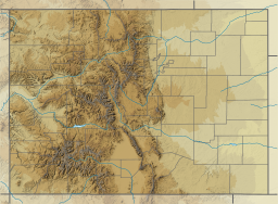
Chambers Lake, at 9,300 feet above sea level in the
Medicine Bow Range, is named for trapper Robert Chambers, who camped there with his son in 1858.
311:
44:
302:
547:
557:
542:
516:
307:
249:
Chambers Lake receives water from
Skyline Ditch, completed in 1894, and several creeks. The ditch carries water from the
509:
364:
211:
207:
76:
297:
218:
226:
154:
262:
404:
258:
254:
222:
142:
225:
owns a large proportion of the company's stock. Water from the reservoir makes its way to the
452:
28:
493:
234:
536:
250:
230:
122:
391:
481:
105:
92:
127:
214:, the reservoir supplies water for irrigation and municipal water supply.
489:
217:
The reservoir is owned by the Water Supply and
Storage Company, based in
143:
155:
137:
Named for Robert
Chambers, a trapper who camped at the site in 1858
257:
watershed. The lake itself and its drainage are part of the
405:"Guide to the Water Supply and Storage Company Collection"
434:. Colorado State University. Public Lands History Center
497:
340:
Colorado State
University. Public Lands History Center
193:
185:
177:
173:
165:
153:
141:
133:
121:
82:
72:
21:
261:watershed, so the ditch is an early example of an
83:
365:"Chambers Lake Fish Survey and Management Data"
517:
8:
149:Fall Creek, Skyline Ditch, Joe Wright Creek
524:
510:
330:
328:
18:
312:United States Department of the Interior
286:
189:11,350 acre⋅ft (14,000,000 m)
292:
290:
51:
7:
478:
476:
169:The Water Supply and Storage Company
409:Colorado State University Libraries
303:Geographic Names Information System
14:
553:Lakes of Larimer County, Colorado
480:
50:
43:
27:
308:United States Geological Survey
192:
184:
176:
277:The lake also offers fishing.
1:
229:. It then flows down through
197:2,791 m (9,157 ft)
71:
496:. You can help Knowledge by
492:state location article is a
372:Colorado Parks and Wildlife
342:. Colorado State University
237:, where it is distributed.
16:Reservoir in Colorado, U.S.
574:
475:
453:"Chambers Lake Campground"
106:40.6045224°N 105.8533750°W
548:Roosevelt National Forest
212:Roosevelt National Forest
38:
26:
558:Colorado geography stubs
208:Larimer County, Colorado
111:40.6045224; -105.8533750
77:Larimer County, Colorado
392:Chambers Lake, Colorado
253:, which is part of the
181:255 acres (103 ha)
543:Reservoirs in Colorado
455:. USDA Forest Service
363:Davies, Kurt (2013).
227:Cache la Poudre River
210:. Located within the
394:. Viewed: 2017-08-31
64:Location in Colorado
263:interbasin transfer
102: /
259:South Platte River
255:North Platte River
206:is a reservoir in
33:The lake in summer
505:
504:
201:
200:
194:Surface elevation
565:
526:
519:
512:
484:
477:
464:
463:
461:
460:
449:
443:
442:
440:
439:
428:
422:
421:
416:
415:
401:
395:
388:
382:
381:
379:
378:
369:
360:
354:
353:
348:
347:
336:"Chambrers Lake"
332:
323:
322:
320:
318:
294:
161:Joe Wright Creek
157:
156:Primary outflows
145:
117:
116:
114:
113:
112:
107:
103:
100:
99:
98:
95:
85:
54:
53:
47:
31:
19:
573:
572:
568:
567:
566:
564:
563:
562:
533:
532:
531:
530:
473:
470:
468:
467:
458:
456:
451:
450:
446:
437:
435:
432:"Skyline Ditch"
430:
429:
425:
413:
411:
403:
402:
398:
389:
385:
376:
374:
367:
362:
361:
357:
345:
343:
334:
333:
326:
316:
314:
298:"Chambers Lake"
296:
295:
288:
283:
271:
243:
166:Managing agency
144:Primary inflows
110:
108:
104:
101:
96:
93:
91:
89:
88:
68:
67:
66:
65:
62:
61:
60:
59:
55:
34:
17:
12:
11:
5:
571:
569:
561:
560:
555:
550:
545:
535:
534:
529:
528:
521:
514:
506:
503:
502:
485:
466:
465:
444:
423:
396:
383:
355:
324:
285:
284:
282:
279:
270:
267:
242:
239:
235:Eastern Plains
233:to Colorado's
221:. The city of
199:
198:
195:
191:
190:
187:
183:
182:
179:
175:
174:
171:
170:
167:
163:
162:
159:
151:
150:
147:
139:
138:
135:
131:
130:
125:
119:
118:
86:
80:
79:
74:
70:
69:
63:
57:
56:
49:
48:
42:
41:
40:
39:
36:
35:
32:
24:
23:
15:
13:
10:
9:
6:
4:
3:
2:
570:
559:
556:
554:
551:
549:
546:
544:
541:
540:
538:
527:
522:
520:
515:
513:
508:
507:
501:
499:
495:
491:
486:
483:
479:
474:
471:
454:
448:
445:
433:
427:
424:
420:
410:
406:
400:
397:
393:
387:
384:
373:
366:
359:
356:
352:
341:
337:
331:
329:
325:
313:
309:
305:
304:
299:
293:
291:
287:
280:
278:
275:
268:
266:
265:in Colorado.
264:
260:
256:
252:
251:Laramie River
247:
240:
238:
236:
232:
231:Poudre Canyon
228:
224:
220:
215:
213:
209:
205:
204:Chambers Lake
196:
188:
180:
172:
168:
164:
160:
158:
152:
148:
146:
140:
136:
132:
129:
126:
124:
120:
115:
87:
81:
78:
75:
58:Chambers Lake
46:
37:
30:
25:
22:Chambers Lake
20:
498:expanding it
487:
472:
469:
457:. Retrieved
447:
436:. Retrieved
426:
418:
412:. Retrieved
408:
399:
386:
375:. Retrieved
371:
358:
350:
344:. Retrieved
339:
315:. Retrieved
301:
276:
272:
248:
244:
219:Fort Collins
216:
203:
202:
186:Water volume
178:Surface area
390:Lakepedia.
109: /
97:105°51′12″W
84:Coordinates
537:Categories
459:2017-09-01
438:2017-09-01
414:2017-08-31
377:2017-08-31
346:2017-08-31
281:References
269:Recreation
94:40°36′16″N
134:Etymology
128:Reservoir
490:Colorado
223:Thornton
73:Location
317:Jan 15,
241:History
488:This
368:(PDF)
494:stub
319:2021
123:Type
539::
417:.
407:.
370:.
349:.
338:.
327:^
310:,
306:.
300:.
289:^
525:e
518:t
511:v
500:.
462:.
441:.
380:.
321:.
Text is available under the Creative Commons Attribution-ShareAlike License. Additional terms may apply.