517:
666:
66:
436:
450:
53:
73:
335:
arrives from the southeast by crossing the
Chambly rapids for a length of approximately 1.35 kilometres (0.84 mi), i.e. downstream from the Yule bridge which spans this river in order to connect Chambly (west bank) and
692:
591:
476:
Atlas of Canada from the
Department of Natural Resources Canada - Characteristics extracted from the geographic map, the database and site instrumentation - accessed May 18, 2020.
621:
344:
170:
697:
323:. Its surface is generally frozen from mid-December to the end of March. The water level of the river varies with the seasons and the precipitation.
120:
641:
355:
65:
586:
687:
413:
320:
340:(east bank). These rapids end at the height of an archipelago of small islands bordering the south-eastern shore of the basin.
366:(residential area). Channels separate these islands. These islands are part of the territory of the city of Carignan. The
312:
The
Chambly Basin is an important area for recreational tourism activities including boating in the summer, the connected
601:
302:
249:
351:
pours its waters on the south shore of the basin, in the area of the
Chambly Canal National Historic Site of Canada.
416:
of
Chambly. It's referred to as a "basin" as it's a shallow lake in which alluvium is deposited. The name French:
656:
547:
20:
421:
389:, wrote: "The entrance to the sault is a kind of lake, where the water goes down, which contains some three
651:
449:
185:
528:
435:
404:, we read: "This basin is like a small lake, a league and a half of a turn, six to eight feet deep. "
574:
487:
382:
569:
162:
596:
564:
337:
290:
245:
606:
491:
397:
306:
253:
374:, that is 1.0 kilometre (0.62 mi) downstream of the limit north of the Chambly basin.
298:
98:
616:
611:
332:
286:
278:
257:
192:
174:
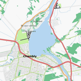
94:
42:
199:
681:
646:
626:
390:
359:
348:
313:
178:
152:
671:
636:
631:
371:
367:
363:
331:
The shape of the basin is similar to the shape of a football. The current from the
317:
52:
661:
559:
135:
122:
475:
274:
370:
which runs on the west side of
Chambly drains at the northeast point of
163:
186:
294:
282:
106:
102:
401:
386:
347:
flows toward the middle of the eastern shore of the basin. The
500:]. Vol. Tome III, Livre Second. p. 181
693:
La Vallée-du-Richelieu
Regional County Municipality
592:
La Vallée-du-Richelieu
Regional County Municipality
241:
237:
229:
221:
213:
209:
198:
184:
161:
151:
112:
90:
28:
113:
412:Chambly Basin was named after the surrounding
385:, the European to explore this body water in
8:
34:
25:
468:
431:
354:The western part of the basin includes
233:11 to 100 ft (3.4 to 30.5 m)
698:Rouville Regional County Municipality
587:Rouville Regional County Municipality
281:, extending out from the foot of the
72:
7:
362:(residential area), Île au Foin and
301:. The towns of Chambly, Richelieu,
16:Body of water in Montérégie, Quebec
14:
529:Commission de toponymie du Québec
664:
448:
434:
277:formed by an enlargement of the
71:
64:
51:
228:
220:
212:
518:Google Books: Jesuit Relations
1:
420:was formalized by the Quebec
169:(clockwise) ruisseau Wilson,
89:
657:List of lakes of Montérégie
602:Saint-Mathias-sur-Richelieu
575:GPX (secondary coordinates)
303:Saint-Mathias-sur-Richelieu
250:Saint-Mathias-sur-Richelieu
225:1.34 mi (2.16 km)
217:1.98 mi (3.18 km)
714:
18:
570:GPX (primary coordinates)
545:Map all coordinates using
59:
50:
33:
553:Download coordinates as:
21:Chambly (disambiguation)
490:(2018-05-04) . "VIII".
422:Commission of Geography
321:National Historic Sites
273:) is a shallow, oblong
417:
270:
35:
652:Seigneurie de Chambly
565:GPX (all coordinates)
285:on the river between
136:45.46111°N 73.28333°W
493:Oeuvres de Champlain
463:Notes and references
309:surround the basin.
19:For other uses, see
688:Lakes of Montérégie
488:Samuel de Champlain
383:Samuel de Champlain
141:45.46111; -73.28333
132: /
622:Rivière des Hurons
498:Works of Champlain
456:Rapides de Chambly
345:Rivière des Hurons
171:rivière des Hurons
418:Bassin de Chambly
271:bassin de Chambly
263:
262:
230:Surface elevation
36:bassin de Chambly
705:
674:
669:
668:
667:
531:
526:
520:
515:
509:
508:
506:
505:
484:
478:
473:
452:
438:
398:Jesuit Relations
188:
187:Primary outflows
165:
147:
146:
144:
143:
142:
137:
133:
130:
129:
128:
125:
115:
75:
74:
68:
55:
46:
38:
26:
713:
712:
708:
707:
706:
704:
703:
702:
678:
677:
670:
665:
663:
642:Île aux Lièvres
617:Richelieu River
583:
582:
581:
580:
579:
540:
535:
534:
527:
523:
516:
512:
503:
501:
486:
485:
481:
474:
470:
465:
458:
457:
453:
444:
443:
439:
430:
410:
380:
356:Île aux Lièvres
333:Richelieu River
329:
279:Richelieu River
202: countries
193:Richelieu River
175:Richelieu River
164:Primary inflows
140:
138:
134:
131:
126:
123:
121:
119:
118:
86:
85:
84:
83:
82:
81:
80:
76:
40:
24:
17:
12:
11:
5:
711:
709:
701:
700:
695:
690:
680:
679:
676:
675:
660:
659:
654:
649:
644:
639:
634:
629:
624:
619:
614:
609:
604:
599:
594:
589:
578:
577:
572:
567:
562:
556:
550:
543:
542:
541:
539:
536:
533:
532:
521:
510:
479:
467:
466:
464:
461:
460:
459:
455:
454:
447:
445:
441:
440:
433:
429:
426:
409:
406:
379:
376:
328:
325:
261:
260:
243:
239:
238:
235:
234:
231:
227:
226:
223:
219:
218:
215:
211:
210:
207:
206:
203:
196:
195:
190:
182:
181:
167:
159:
158:
155:
149:
148:
116:
110:
109:
92:
88:
87:
78:
77:
70:
69:
63:
62:
61:
60:
57:
56:
48:
47:
31:
30:
15:
13:
10:
9:
6:
4:
3:
2:
710:
699:
696:
694:
691:
689:
686:
685:
683:
673:
662:
658:
655:
653:
650:
648:
647:Demers Island
645:
643:
640:
638:
635:
633:
630:
628:
627:Chambly Canal
625:
623:
620:
618:
615:
613:
610:
608:
605:
603:
600:
598:
595:
593:
590:
588:
585:
584:
576:
573:
571:
568:
566:
563:
561:
558:
557:
555:
554:
549:
548:OpenStreetMap
546:
537:
530:
525:
522:
519:
514:
511:
499:
495:
494:
489:
483:
480:
477:
472:
469:
462:
451:
446:
442:Chambly basin
437:
432:
428:Image gallery
427:
425:
423:
419:
415:
407:
405:
403:
399:
394:
392:
388:
384:
377:
375:
373:
369:
365:
361:
360:Demers Island
357:
352:
350:
349:Chambly Canal
346:
341:
339:
334:
326:
324:
322:
319:
315:
314:Chambly Canal
310:
308:
304:
300:
296:
292:
288:
284:
280:
276:
275:body of water
272:
268:
267:Chambly Basin
259:
255:
251:
247:
244:
240:
236:
232:
224:
216:
208:
204:
201:
197:
194:
191:
189:
183:
180:
179:Chambly Canal
176:
172:
168:
166:
160:
156:
154:
150:
145:
117:
111:
108:
104:
100:
96:
93:
79:Chambly Basin
67:
58:
54:
49:
44:
37:
32:
29:Chambly Basin
27:
22:
672:Lakes portal
637:Goyer Island
632:Fort Chambly
552:
551:
544:
524:
513:
502:. Retrieved
497:
492:
482:
471:
411:
395:
381:
372:Goyer Island
368:Acadia River
364:Goyer Island
353:
342:
330:
318:Fort Chambly
311:
266:
264:
316:and nearby
242:Settlements
214:Max. length
139: /
114:Coordinates
682:Categories
504:2022-01-07
299:Montérégie
297:region of
222:Max. width
127:73°17′00″W
124:45°27′40″N
99:Montérégie
597:Richelieu
424:in 1968.
338:Richelieu
327:Geography
293:, in the
291:Richelieu
269:(French:
246:Richelieu
607:Carignan
538:See also
414:seignory
393:round."
307:Carignan
254:Carignan
91:Location
612:Chambly
391:leagues
378:History
287:Chambly
258:Chambly
95:Chambly
295:Quebec
283:rapids
205:Canada
107:Canada
103:Quebec
43:French
39:
496:[
200:Basin
157:basin
408:Name
402:1665
387:1609
343:The
305:and
289:and
265:The
256:and
153:Type
560:KML
400:of
396:In
684::
358:,
252:,
248:,
177:,
173:,
105:,
101:,
97:,
507:.
45:)
41:(
23:.
Text is available under the Creative Commons Attribution-ShareAlike License. Additional terms may apply.