55:
40:
324:
as 'the most beautiful river in the kingdom', and was navigable in its natural state until mills were erected at many locations in the 14th century. Some locks were built but through navigation remained impossible for centuries. Improvements to the navigation were projected under Louis XVI in 1772,
486:
253:
394:
The river
Boutonne is navigable over a distance of 31 km to Saint-Jean-d'Angély, but a barrier at the confluence prevents access except under exceptional conditions.
325:
but work was interrupted by the
Revolution. The project was revived under the Restoration and canalisation completed in 1835. The waterway was abandoned in 1957. The
352:
make the river a popular destination for boaters, mainly in rental boats, with moorings provided at most towns and villages along the route. The
594:
459:
599:
513:
584:
329:
took over operation in 1963, and recreational vessels have now taken possession of the waterway throughout the 164 km to the town of
162:
589:
423:
528:
411:
349:
309:
579:
427:
407:
345:
569:
54:
574:
353:
276:
490:
543:
464:
321:
297:
553:
443:
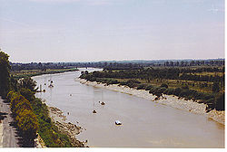
509:
301:
271:) is a 381-kilometre (237 mi) long river in southwestern France. Its source is in the
267:
259:
76:
415:
246:
45:
447:
431:
419:
337:
305:
148:
39:
563:
376:
289:
285:
272:
122:
439:
330:
281:
364:
133:
17:
177:
164:
403:
388:
384:
372:
293:
508:. St Ives, Cambs., UK: Imray Laurie Norie & Wilson Ltd. p. 67.
368:
435:
380:
341:
93:
546:, with maps and details for navigation, by the author of
68:
221:
213:
201:
193:
154:
142:
132:
116:
108:
99:
89:
84:
64:
32:
554:Navigation details for 80 French rivers and canals
320:The Charente was described by the French king
8:
491:"Fiche cours d'eau - La Charente (R---0000)"
356:are 34.8 by 6.5 metres (114 by 21 ft).
53:
481:
479:
475:
460:Kaolin deposits of the Charentes Basin
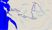
288:. It flows through the departments of
205:10,000 km (3,900 sq mi)
29:
266:
245:
227:40 m/s (1,400 cu ft/s)
59:The Charente and its main tributaries
7:
556:(French waterways website section)
25:
544:River Charente and River Boutonne
450:are on the river's upper course.
38:
442:on the navigable river, while
156: • coordinates
1:
595:Rivers of Vienne (department)
100:Physical characteristics
600:Rivers of Nouvelle-Aquitaine
27:River in southwestern France
585:Rivers of Charente-Maritime
504:Edwards-May, David (2010).
402:Towns and villages include
304:. The river flows into the
144: • location
118: • location
616:
548:Inland Waterways of France
506:Inland Waterways of France
223: • average
231:
209:
197:381 km (237 mi)
128:
104:
52:
37:
529:Charente (amont et aval)
418:on the tidal river, and
284:, a small village near
590:Rivers of Haute-Vienne
387:, Arnoult, Touvre and
336:The historic towns of
263:
69:
178:45.95667°N 1.08222°W
465:History of Charente
367:include the rivers
268:[tʃaˈɾantɔ]
174: /
580:Rivers of Charente
550:, referenced above
444:Montignac-Charente
438:, Saint-Simon and
183:45.95667; -1.08222
515:978-1-846230-14-1
302:Charente-Maritime
235:
234:
16:(Redirected from
607:
570:Rivers of France
532:
526:
520:
519:
501:
495:
494:
483:
270:
257:
256:
255:
249:
247:[ʃaʁɑ̃t]
244:
224:
189:
188:
186:
185:
184:
179:
175:
172:
171:
170:
167:
119:
80:
72:
57:
44:The Charente in
42:
30:
21:
615:
614:
610:
609:
608:
606:
605:
604:
560:
559:
540:
535:
527:
523:
516:
503:
502:
498:
485:
484:
477:
473:
456:
416:Tonnay-Charente
400:
362:
318:
252:
251:
250:
242:
222:
182:
180:
176:
173:
168:
165:
163:
161:
160:
157:
145:
117:
74:
60:
48:
46:Tonnay-Charente
28:
23:
22:
15:
12:
11:
5:
613:
611:
603:
602:
597:
592:
587:
582:
577:
575:Charente basin
572:
562:
561:
558:
557:
551:
539:
538:External links
536:
534:
533:
521:
514:
496:
474:
472:
469:
468:
467:
462:
455:
452:
420:Saint-Savinien
399:
396:
361:
358:
317:
314:
306:Atlantic Ocean
233:
232:
229:
228:
225:
219:
218:
215:
211:
210:
207:
206:
203:
199:
198:
195:
191:
190:
158:
155:
152:
151:
149:Atlantic Ocean
146:
143:
140:
139:
136:
130:
129:
126:
125:
120:
114:
113:
110:
106:
105:
102:
101:
97:
96:
91:
87:
86:
82:
81:
66:
62:
61:
58:
50:
49:
43:
35:
34:
26:
24:
18:Charente River
14:
13:
10:
9:
6:
4:
3:
2:
612:
601:
598:
596:
593:
591:
588:
586:
583:
581:
578:
576:
573:
571:
568:
567:
565:
555:
552:
549:
545:
542:
541:
537:
531:, Fluviacarte
530:
525:
522:
517:
511:
507:
500:
497:
492:
488:
482:
480:
476:
470:
466:
463:
461:
458:
457:
453:
451:
449:
445:
441:
437:
433:
429:
425:
421:
417:
413:
409:
405:
397:
395:
392:
390:
386:
382:
378:
374:
370:
366:
359:
357:
355:
351:
347:
343:
339:
334:
332:
328:
323:
315:
313:
311:
307:
303:
299:
295:
291:
287:
283:
279:
278:
274:
269:
265:
261:
254:
248:
240:
230:
226:
220:
216:
212:
208:
204:
200:
196:
192:
187:
159:
153:
150:
147:
141:
137:
135:
131:
127:
124:
121:
115:
111:
107:
103:
98:
95:
92:
88:
83:
78:
71:
67:
63:
56:
51:
47:
41:
36:
31:
19:
547:
524:
505:
499:
401:
393:
383:, Bramerit,
363:
335:
327:départements
326:
319:
290:Haute-Vienne
286:Rochechouart
275:
273:Haute-Vienne
238:
236:
123:Haute-Vienne
424:Taillebourg
365:Tributaries
360:Tributaries
277:département
181: /
65:Native name
564:Categories
471:References
322:François I
316:Navigation
202:Basin size
166:45°57′24″N
440:Angoulême
412:Rochefort
404:Vergeroux
389:Bonnieure
379:, Coran,
350:Rochefort
331:Angoulême
310:Rochefort
282:Chéronnac
214:Discharge
454:See also
398:En route
385:Boutonne
294:Charente
264:Charanta
239:Charente
169:1°4′56″W
85:Location
70:Charanta
33:Charente
428:Saintes
408:Soubise
369:Antenne
346:Saintes
260:Occitan
243:French:
90:Country
77:Occitan
512:
487:Sandre
448:Civray
436:Jarnac
432:Cognac
381:Seugne
342:Jarnac
338:Cognac
298:Vienne
217:
194:Length
138:
112:
109:Source
94:France
73:
373:Boëme
354:locks
308:near
134:Mouth
510:ISBN
446:and
414:and
348:and
300:and
237:The
333:.
280:at
566::
489:.
478:^
434:,
430:,
426:,
422:,
410:,
406:,
391:.
377:Né
375:,
371:,
344:,
340:,
312:.
296:,
292:,
262::
258:;
518:.
493:.
241:(
79:)
75:(
20:)
Text is available under the Creative Commons Attribution-ShareAlike License. Additional terms may apply.