713:
55:
1156:
40:
630:
180:
712:
690:
In the township, the population was spread out, with 25.8% under the age of 18, 10.8% from 18 to 24, 28.3% from 25 to 44, 25.2% from 45 to 64, and 9.9% who were 65 years of age or older. The median age was 37 years. For every 100 females there were 95.0 males. For every 100 females age 18 and over,
646:
of 2000, there were 4,051 people, 1,340 households, and 1,003 families living in the township. The population density was 323.3 inhabitants per square mile (124.8/km). There were 1,397 housing units at an average density of 111.5 per square mile (43.1/km). The racial makeup of the township was
686:
living together, 4.9% had a female householder with no husband present, and 25.1% were non-families. 20.4% of all households were made up of individuals, and 5.8% had someone living alone who was 65 years of age or older. The average household size was 2.73 and the average family size was 3.21.
613:
At the 2010 census, the township was 84.4% non-Hispanic White, 2.3% Black or
African American, 0.2% Native American, 9.0% Asian, and 1.8% were two or more races. 2.6% of the population were of Hispanic or Latino ancestry
694:
The median income for a household in the township was $ 89,813, and the median income for a family was $ 101,922. Males had a median income of $ 77,386 versus $ 46,026 for females. The
1492:
1297:
1094:
2150:
1377:
362:, the township has a total area of 12.6 square miles (33 km), of which 12.5 square miles (32 km) is land and 0.04 square miles (0.10 km) (0.16%) is water.
1427:
1262:
371:
311:
1437:
1422:
1352:
1347:
1472:
752:
along the township's southeastern border. PA 29 follows
Charlestown Road and State Road along a north-south alignment through the eastern parts of the township.
72:
1462:
54:
2097:
748:, is the main highway serving Charlestown Township. It follows an east-west alignment through the southern portion of the township, with an interchange with
1407:
1869:
1342:
1087:
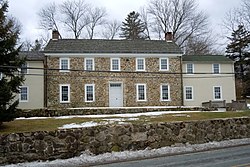
1669:
734:
729:
As of 2018, there were 50.02 miles (80.50 km) of public roads in
Charlestown Township, of which 4.40 miles (7.08 km) were maintained by the
1955:
1714:
327:
253:
860:
1884:
1502:
1307:
891:
1915:
1889:
1719:
1512:
1482:
1317:
1282:
1532:
1432:
1402:
1367:
1332:
1080:
389:
383:
323:
1033:
1522:
1517:
1507:
1477:
1452:
1322:
1312:
1292:
1277:
926:
407:
401:
347:
1527:
1447:
1382:
1372:
1327:
945:
1497:
1357:
1302:
970:
1547:
1442:
1392:
1387:
377:
39:
1799:
1659:
1487:
1412:
1287:
1137:
784:
730:
212:
1072:
1789:
1759:
1542:
1417:
1337:
1229:
814:
2000:
1467:
1457:
1362:
664:
652:
395:
1774:
1699:
1397:
745:
716:
656:
307:
2046:
1975:
1970:
1199:
1104:
765:
288:
246:
125:
2120:
1990:
1900:
1739:
1694:
1267:
988:
668:
359:
2061:
2020:
2015:
1960:
1935:
1920:
1854:
1779:
1709:
1608:
1598:
1587:
1239:
1224:
1126:
303:
2082:
2005:
1995:
1895:
1879:
1844:
1834:
1824:
1744:
1581:
1234:
1194:
1184:
1145:
580:
565:
550:
535:
520:
505:
490:
475:
460:
445:
296:
2092:
2035:
2030:
1985:
1945:
1940:
1859:
1804:
1764:
1749:
1674:
1649:
1244:
1219:
241:
682:
There were 1,340 households, out of which 37.8% had children under the age of 18 living with them, 68.1% were
1575:
2066:
2051:
2040:
1910:
1864:
1829:
1704:
1664:
1654:
1634:
1619:
1557:
1254:
756:
follows
Conestoga Road on a northwest-southeast alignment through the southwestern portion of the township.
335:
284:
30:
2087:
2010:
1874:
1839:
1754:
1689:
1639:
1189:
1179:
1166:
753:
672:
1062:
2071:
2025:
1980:
1905:
1849:
1814:
1809:
1784:
1769:
1684:
1592:
1204:
931:
749:
741:
720:
233:
2127:
2056:
1950:
1930:
1925:
1819:
1794:
1629:
1565:
1214:
1209:
1174:
676:
222:
2076:
1729:
1679:
1644:
1624:
1614:
1603:
660:
648:
331:
44:
1570:
1040:
898:
867:
698:
for the township was $ 41,878. About 1.4% of families and 2.1% of the population were below the
343:
339:
834:
695:
1008:
1965:
949:
846:
2111:‡This populated place also has portions in an adjacent county or counties †Former borough
615:
2144:
699:
292:
115:
60:
1119:
633:
87:
74:
203:
737:(PennDOT) and 26.50 miles (42.65 km) were maintained by the township.
702:, including 3.2% of those under age 18 and 2.1% of those age 65 or over.
683:
643:
310:, is located in Charlestown Township. The other part is located in
861:"2020 CENSUS - CENSUS BLOCK MAP (INDEX): Charlestown township, PA"
711:
229:
208:
1034:"2020 CENSUS - SCHOOL DISTRICT REFERENCE MAP: Chester County, PA"
921:
1076:
1067:
267:
1154:
733:(PTC), 19.12 miles (30.77 km) were maintained by the
984:
892:"2020 CENSUS - CENSUS BLOCK MAP: Schuylkill township, PA"
808:
806:
804:
802:
2106:
1728:
1556:
1253:
1165:
1136:
622:
262:
252:
240:
219:
202:
194:
186:
173:
168:
160:
152:
144:
136:
131:
121:
111:
103:
21:
295:, United States. The population was 6,003 at the
1088:
8:
815:"City and Town Population Totals: 2020-2021"
1095:
1081:
1073:
679:of any race were 1.38% of the population.
418:
314:. The campus straddles the township line.
18:
2151:Townships in Chester County, Pennsylvania
735:Pennsylvania Department of Transportation
328:Middle Pickering Rural Historic District
306:'s campus, formerly the location of the
1068:Charlestown Township - official website
776:
261:
251:
239:
201:
167:
159:
130:
102:
67:
36:
16:Township in Pennsylvania, United States
922:"National Register Information System"
842:
832:
619:
438:
324:Charlestown Village Historic District
218:
193:
185:
172:
151:
148:12.45 sq mi (32.25 km)
143:
140:12.52 sq mi (32.44 km)
135:
120:
110:
51:
7:
927:National Register of Historic Places
671:, and 0.94% from two or more races.
348:National Register of Historic Places
156:0.07 sq mi (0.19 km)
1103:Municipalities and communities of
428:
14:
723:westbound in Charlestown Township
731:Pennsylvania Turnpike Commission
628:
179:
178:
53:
38:
1:
787:. United States Census Bureau
308:Valley Forge General Hospital
198:461.45/sq mi (178.17/km)
1106:Chester County, Pennsylvania
766:Great Valley School District
989:United States Census Bureau
909:Valley Forge Christian Colg
879:Valley Forge Christian Colg
785:"2016 U.S. Gazetteer Files"
187: • Estimate
2167:
1009:"Charlestown Township map"
764:The township is served by
304:University of Valley Forge
2116:
1152:
1117:
627:
607:
594:
579:
564:
549:
534:
519:
504:
489:
474:
459:
444:
437:
432:
427:
424:
68:
52:
37:
28:
946:"DVRPC > Site Search"
870:. p. 2 (PDF p. 3/4)
691:there were 92.2 males.
390:West Whiteland Township
384:East Whiteland Township
336:Oskar G. Stonorov House
164:223 ft (68 m)
1159:
754:Pennsylvania Route 401
724:
408:East Pikeland Township
402:West Pikeland Township
1158:
985:"U.S. Census website"
932:National Park Service
750:Pennsylvania Route 29
742:Pennsylvania Turnpike
721:Pennsylvania Turnpike
715:
634:Scenes of Charlestown
420:Historical population
221: • Summer (
88:40.10028°N 75.55083°W
2129:United States portal
1063:Charlestown Township
281:Charlestown Township
195: • Density
63:in the United States
23:Charlestown Township
2122:Pennsylvania portal
813:Bureau, US Census.
421:
378:Tredyffrin Township
372:Schuylkill Township
332:Martin-Little House
312:Schuylkill Township
93:40.10028; -75.55083
84: /
45:Martin-Little House
1800:Darlington Corners
1660:Lincoln University
1593:Cheyney University
1160:
1041:U.S. Census Bureau
899:U.S. Census Bureau
868:U.S. Census Bureau
845:has generic name (
821:. US Census Bureau
725:
636:, George Cartolaro
419:
366:Adjacent Townships
360:U.S. Census Bureau
346:are listed on the
344:Jacob Wisner House
340:John Williams Farm
174: • Total
153: • Water
137: • Total
2138:
2137:
1230:South Coatesville
696:per capita income
640:
639:
611:
610:
358:According to the
278:
277:
145: • Land
2158:
2130:
2123:
2001:Nantmeal Village
1966:Longwood Gardens
1503:West Marlborough
1493:West Fallowfield
1308:East Marlborough
1298:East Fallowfield
1157:
1129:
1122:
1112:
1107:
1097:
1090:
1083:
1074:
1051:
1050:
1048:
1047:
1038:
1030:
1024:
1023:
1021:
1019:
1013:
1005:
999:
998:
996:
995:
981:
975:
974:
967:
961:
960:
958:
957:
948:. Archived from
942:
936:
935:
918:
912:
911:
906:
905:
896:
888:
882:
881:
876:
875:
865:
857:
851:
850:
844:
840:
838:
830:
828:
826:
810:
797:
796:
794:
792:
781:
744:, also known as
665:Pacific Islander
653:African American
632:
631:
620:
440:
435:
430:
422:
396:Uwchlan Township
274:
271:
269:
226:
182:
181:
99:
98:
96:
95:
94:
89:
85:
82:
81:
80:
77:
57:
42:
19:
2166:
2165:
2161:
2160:
2159:
2157:
2156:
2155:
2141:
2140:
2139:
2134:
2128:
2121:
2112:
2102:
1775:Chester Springs
1731:
1724:
1700:South Pottstown
1552:
1513:West Nottingham
1483:West Brandywine
1318:East Nottingham
1283:East Brandywine
1249:
1161:
1155:
1150:
1132:
1127:
1120:
1113:
1110:
1105:
1101:
1059:
1054:
1045:
1043:
1036:
1032:
1031:
1027:
1017:
1015:
1011:
1007:
1006:
1002:
993:
991:
983:
982:
978:
969:
968:
964:
955:
953:
944:
943:
939:
934:. July 9, 2010.
920:
919:
915:
903:
901:
894:
890:
889:
885:
873:
871:
863:
859:
858:
854:
841:
831:
824:
822:
812:
811:
800:
790:
788:
783:
782:
778:
774:
762:
727:
726:
708:
684:married couples
657:Native American
629:
623:External videos
433:
417:
356:
320:
266:
220:
92:
90:
86:
83:
78:
75:
73:
71:
70:
64:
48:
33:
24:
17:
12:
11:
5:
2164:
2162:
2154:
2153:
2143:
2142:
2136:
2135:
2133:
2132:
2125:
2117:
2114:
2113:
2110:
2108:
2104:
2103:
2101:
2100:
2098:Yellow Springs
2095:
2090:
2085:
2080:
2074:
2069:
2064:
2059:
2054:
2049:
2047:Strickersville
2044:
2038:
2033:
2028:
2023:
2018:
2013:
2008:
2003:
1998:
1993:
1988:
1983:
1978:
1976:Ludwigs Corner
1973:
1971:Lower Hopewell
1968:
1963:
1958:
1953:
1948:
1943:
1938:
1933:
1928:
1923:
1918:
1913:
1908:
1903:
1898:
1893:
1887:
1882:
1877:
1872:
1867:
1862:
1857:
1852:
1847:
1842:
1837:
1832:
1827:
1822:
1817:
1812:
1807:
1802:
1797:
1792:
1787:
1782:
1777:
1772:
1767:
1762:
1757:
1752:
1747:
1742:
1736:
1734:
1726:
1725:
1723:
1722:
1717:
1712:
1707:
1702:
1697:
1692:
1687:
1682:
1677:
1672:
1667:
1662:
1657:
1652:
1647:
1642:
1637:
1632:
1627:
1622:
1617:
1612:
1606:
1601:
1596:
1590:
1585:
1579:
1573:
1568:
1562:
1560:
1554:
1553:
1551:
1550:
1545:
1540:
1539:
1538:
1533:West Whiteland
1530:
1525:
1520:
1515:
1510:
1505:
1500:
1495:
1490:
1485:
1480:
1475:
1470:
1465:
1460:
1455:
1450:
1445:
1440:
1435:
1433:South Coventry
1430:
1425:
1420:
1415:
1410:
1405:
1403:North Coventry
1400:
1395:
1390:
1385:
1380:
1375:
1370:
1368:London Britain
1365:
1360:
1355:
1350:
1345:
1340:
1335:
1333:East Whiteland
1330:
1325:
1320:
1315:
1310:
1305:
1300:
1295:
1290:
1285:
1280:
1275:
1270:
1265:
1259:
1257:
1251:
1250:
1248:
1247:
1242:
1237:
1232:
1227:
1222:
1217:
1212:
1207:
1202:
1200:Kennett Square
1197:
1192:
1187:
1182:
1177:
1171:
1169:
1163:
1162:
1153:
1151:
1149:
1148:
1142:
1140:
1134:
1133:
1118:
1115:
1114:
1102:
1100:
1099:
1092:
1085:
1077:
1071:
1070:
1065:
1058:
1057:External links
1055:
1053:
1052:
1025:
1000:
976:
962:
937:
913:
883:
852:
798:
775:
773:
770:
761:
758:
710:
709:
707:
706:Transportation
704:
638:
637:
625:
624:
609:
608:
605:
604:
601:
599:
596:
592:
591:
588:
586:
583:
577:
576:
573:
571:
568:
562:
561:
558:
556:
553:
547:
546:
543:
541:
538:
532:
531:
528:
526:
523:
517:
516:
513:
511:
508:
502:
501:
498:
496:
493:
487:
486:
483:
481:
478:
472:
471:
468:
466:
463:
457:
456:
453:
451:
448:
442:
441:
436:
431:
426:
416:
413:
412:
411:
405:
399:
393:
387:
381:
375:
355:
352:
319:
316:
289:Chester County
276:
275:
264:
260:
259:
256:
250:
249:
244:
238:
237:
227:
217:
216:
206:
200:
199:
196:
192:
191:
188:
184:
183:
175:
171:
170:
166:
165:
162:
158:
157:
154:
150:
149:
146:
142:
141:
138:
134:
133:
129:
128:
123:
119:
118:
113:
109:
108:
105:
101:
100:
66:
65:
58:
50:
49:
43:
35:
34:
29:
26:
25:
22:
15:
13:
10:
9:
6:
4:
3:
2:
2163:
2152:
2149:
2148:
2146:
2131:
2126:
2124:
2119:
2118:
2115:
2109:
2105:
2099:
2096:
2094:
2091:
2089:
2086:
2084:
2081:
2078:
2075:
2073:
2070:
2068:
2065:
2063:
2060:
2058:
2055:
2053:
2050:
2048:
2045:
2042:
2039:
2037:
2034:
2032:
2029:
2027:
2024:
2022:
2019:
2017:
2014:
2012:
2009:
2007:
2004:
2002:
1999:
1997:
1994:
1992:
1991:Milford Mills
1989:
1987:
1984:
1982:
1979:
1977:
1974:
1972:
1969:
1967:
1964:
1962:
1959:
1957:
1954:
1952:
1949:
1947:
1944:
1942:
1939:
1937:
1934:
1932:
1929:
1927:
1924:
1922:
1919:
1917:
1914:
1912:
1909:
1907:
1904:
1902:
1901:Humphreyville
1899:
1897:
1894:
1891:
1888:
1886:
1883:
1881:
1878:
1876:
1873:
1871:
1868:
1866:
1863:
1861:
1858:
1856:
1853:
1851:
1848:
1846:
1843:
1841:
1838:
1836:
1833:
1831:
1828:
1826:
1823:
1821:
1818:
1816:
1813:
1811:
1808:
1806:
1803:
1801:
1798:
1796:
1793:
1791:
1790:Coventryville
1788:
1786:
1783:
1781:
1778:
1776:
1773:
1771:
1768:
1766:
1763:
1761:
1760:Byers Station
1758:
1756:
1753:
1751:
1748:
1746:
1743:
1741:
1740:Birchrunville
1738:
1737:
1735:
1733:
1727:
1721:
1718:
1716:
1713:
1711:
1708:
1706:
1703:
1701:
1698:
1696:
1695:Sadsburyville
1693:
1691:
1688:
1686:
1683:
1681:
1678:
1676:
1673:
1671:
1668:
1666:
1663:
1661:
1658:
1656:
1653:
1651:
1648:
1646:
1643:
1641:
1638:
1636:
1633:
1631:
1628:
1626:
1623:
1621:
1618:
1616:
1613:
1610:
1607:
1605:
1602:
1600:
1597:
1594:
1591:
1589:
1586:
1583:
1580:
1577:
1574:
1572:
1569:
1567:
1564:
1563:
1561:
1559:
1555:
1549:
1546:
1544:
1541:
1536:
1535:
1534:
1531:
1529:
1526:
1524:
1523:West Sadsbury
1521:
1519:
1518:West Pikeland
1516:
1514:
1511:
1509:
1508:West Nantmeal
1506:
1504:
1501:
1499:
1496:
1494:
1491:
1489:
1486:
1484:
1481:
1479:
1478:West Bradford
1476:
1474:
1471:
1469:
1466:
1464:
1461:
1459:
1456:
1454:
1453:Upper Uwchlan
1451:
1449:
1446:
1444:
1441:
1439:
1436:
1434:
1431:
1429:
1426:
1424:
1421:
1419:
1416:
1414:
1411:
1409:
1406:
1404:
1401:
1399:
1396:
1394:
1391:
1389:
1386:
1384:
1381:
1379:
1376:
1374:
1371:
1369:
1366:
1364:
1361:
1359:
1356:
1354:
1351:
1349:
1346:
1344:
1341:
1339:
1336:
1334:
1331:
1329:
1326:
1324:
1323:East Pikeland
1321:
1319:
1316:
1314:
1313:East Nantmeal
1311:
1309:
1306:
1304:
1301:
1299:
1296:
1294:
1293:East Coventry
1291:
1289:
1286:
1284:
1281:
1279:
1278:East Bradford
1276:
1274:
1271:
1269:
1266:
1264:
1261:
1260:
1258:
1256:
1252:
1246:
1243:
1241:
1238:
1236:
1233:
1231:
1228:
1226:
1223:
1221:
1218:
1216:
1213:
1211:
1208:
1206:
1203:
1201:
1198:
1196:
1193:
1191:
1188:
1186:
1183:
1181:
1178:
1176:
1173:
1172:
1170:
1168:
1164:
1147:
1144:
1143:
1141:
1139:
1135:
1131:
1130:
1123:
1116:
1111:United States
1108:
1098:
1093:
1091:
1086:
1084:
1079:
1078:
1075:
1069:
1066:
1064:
1061:
1060:
1056:
1042:
1035:
1029:
1026:
1010:
1004:
1001:
990:
986:
980:
977:
972:
971:"Census 2020"
966:
963:
952:on 2019-04-09
951:
947:
941:
938:
933:
929:
928:
923:
917:
914:
910:
900:
893:
887:
884:
880:
869:
862:
856:
853:
848:
836:
820:
816:
809:
807:
805:
803:
799:
786:
780:
777:
771:
769:
767:
759:
757:
755:
751:
747:
743:
738:
736:
732:
722:
718:
714:
705:
703:
701:
697:
692:
688:
685:
680:
678:
674:
670:
667:, 0.25% from
666:
662:
658:
654:
650:
645:
635:
626:
621:
618:
616:
606:
602:
600:
597:
593:
589:
587:
584:
582:
578:
574:
572:
569:
567:
563:
559:
557:
554:
552:
548:
544:
542:
539:
537:
533:
529:
527:
524:
522:
518:
514:
512:
509:
507:
503:
499:
497:
494:
492:
488:
484:
482:
479:
477:
473:
469:
467:
464:
462:
458:
454:
452:
449:
447:
443:
423:
414:
409:
406:
403:
400:
397:
394:
391:
388:
385:
382:
379:
376:
373:
370:
369:
368:
367:
363:
361:
353:
351:
349:
345:
341:
337:
333:
329:
325:
317:
315:
313:
309:
305:
300:
298:
294:
290:
286:
282:
273:
265:
257:
255:
248:
245:
243:
235:
231:
228:
224:
214:
210:
207:
205:
197:
189:
176:
163:
155:
147:
139:
127:
124:
117:
114:
107:United States
106:
97:
69:Coordinates:
62:
56:
46:
41:
32:
27:
20:
2062:Valley Forge
2016:Russellville
1961:London Grove
1936:Kemblesville
1921:Jennersville
1870:Hickory Hill
1855:Harmonyville
1780:Chesterville
1710:Toughkenamon
1609:Dilworthtown
1599:Cochranville
1588:Chesterbrook
1528:West Vincent
1448:Upper Oxford
1383:Lower Oxford
1373:London Grove
1328:East Vincent
1272:
1240:West Chester
1225:Phoenixville
1128:West Chester
1125:
1044:. Retrieved
1028:
1016:. Retrieved
1003:
992:. Retrieved
979:
965:
954:. Retrieved
950:the original
940:
925:
916:
908:
902:. Retrieved
886:
878:
872:. Retrieved
855:
843:|last1=
823:. Retrieved
818:
789:. Retrieved
779:
763:
739:
728:
700:poverty line
693:
689:
681:
641:
612:
415:Demographics
365:
364:
357:
321:
302:Part of the
301:
293:Pennsylvania
280:
279:
270:.charlestown
258:42-029-12744
242:Area code(s)
116:Pennsylvania
61:Pennsylvania
59:Location of
47:, built 1735
2083:West Goshen
2006:Parker Ford
1996:Mortonville
1896:Howellville
1880:Hinsonville
1845:Goshenville
1835:Faggs Manor
1825:Embreeville
1745:Black Horse
1732:communities
1670:Marshallton
1582:Chadds Ford
1498:West Goshen
1378:Londonderry
1358:Honey Brook
1303:East Goshen
1273:Charlestown
1235:Spring City
1195:Honey Brook
1185:Downingtown
1146:Coatesville
1121:County seat
669:other races
595:2021 (est.)
392:(southwest)
380:(southeast)
374:(northeast)
91: /
2093:Willowdale
2036:Steelville
2031:Springdell
2021:St. Peters
1986:Mendenhall
1956:Lewisville
1946:Landenberg
1941:Knauertown
1860:Hayesville
1805:Daylesford
1765:Cedarville
1750:Brandamore
1715:Unionville
1675:Nottingham
1650:Kenilworth
1548:Willistown
1443:Tredyffrin
1428:Schuylkill
1393:New London
1388:New Garden
1263:Birmingham
1245:West Grove
1220:Parkesburg
1046:2024-02-18
994:2008-01-31
956:2014-03-21
904:2024-02-18
874:2024-02-18
819:Census.gov
772:References
642:As of the
169:Population
79:75°33′03″W
76:40°06′01″N
2107:Footnotes
2067:Wagontown
2052:Sugartown
2041:Strafford
1911:Ironsides
1885:Homeville
1865:Hephzibah
1830:Ercildoun
1705:Thorndale
1665:Lionville
1655:Kimberton
1635:Glenmoore
1620:Eagleview
1576:Cambridge
1488:West Caln
1438:Thornbury
1413:Pennsbury
1288:East Caln
1255:Townships
1018:March 13,
1014:. PennDOT
760:Education
354:Geography
254:FIPS code
204:Time zone
161:Elevation
2145:Category
2088:Whitford
2011:Pocopson
1916:Isabella
1890:Hopewell
1875:Hiestand
1840:Glenloch
1755:Bucktown
1720:Westwood
1690:Pughtown
1640:Hamorton
1543:Westtown
1537:Morstein
1423:Sadsbury
1418:Pocopson
1353:Highland
1348:Franklin
1338:Easttown
1190:Elverson
1180:Avondale
1167:Boroughs
835:cite web
673:Hispanic
663:, 0.02%
659:, 1.70%
655:, 0.17%
651:, 1.56%
299:census.
285:township
31:Township
2072:Warwick
2026:Siousca
1981:Lyndell
1906:Icedale
1850:Hallman
1815:Doe Run
1810:Devault
1785:Compass
1770:Chatham
1685:Pomeroy
1473:Warwick
1468:Wallace
1458:Uwchlan
1363:Kennett
1205:Malvern
825:12 July
791:Aug 13,
647:95.36%
410:(north)
386:(south)
318:History
263:Website
126:Chester
104:Country
2057:Suplee
1951:Lenape
1931:Kelton
1926:Kaolin
1820:Dorlan
1795:Cromby
1630:Frazer
1566:Berwyn
1463:Valley
1398:Newlin
1215:Oxford
1210:Modena
1175:Atglen
677:Latino
644:census
530:−21.5%
500:126.1%
425:Census
404:(west)
398:(west)
342:, and
177:6,003
122:County
2077:Wayne
1730:Other
1680:Paoli
1645:Hayti
1625:Exton
1615:Eagle
1604:Devon
1037:(PDF)
1012:(PDF)
895:(PDF)
864:(PDF)
661:Asian
649:White
598:6,223
585:6,003
575:40.0%
570:5,671
560:47.1%
555:4,051
545:−0.6%
540:2,754
525:2,770
515:82.7%
510:3,528
495:1,931
485:17.6%
283:is a
230:UTC-4
209:UTC-5
190:6,223
112:State
1571:Caln
1558:CDPs
1408:Penn
1268:Caln
1138:City
1020:2023
847:help
827:2022
793:2017
746:I-76
740:The
717:I-76
603:3.7%
590:5.9%
581:2020
566:2010
551:2000
536:1990
521:1980
506:1970
491:1960
476:1950
470:0.8%
461:1940
446:1930
434:Note
429:Pop.
322:The
297:2020
272:.org
132:Area
1343:Elk
675:or
480:854
465:726
450:720
287:in
268:www
247:610
234:EDT
223:DST
213:EST
2147::
1124::
1109:,
1039:.
987:.
930:.
924:.
907:.
897:.
877:.
866:.
839::
837:}}
833:{{
817:.
801:^
768:.
617:.
439:%±
350:.
338:,
334:,
330:,
326:,
291:,
2079:‡
2043:‡
1892:†
1611:‡
1595:‡
1584:‡
1578:‡
1096:e
1089:t
1082:v
1049:.
1022:.
997:.
973:.
959:.
849:)
829:.
795:.
719:/
455:—
236:)
232:(
225:)
215:)
211:(
Text is available under the Creative Commons Attribution-ShareAlike License. Additional terms may apply.