42:
29:
49:
167:
that resulted in the 350-square-kilometre (140 sq mi) lake reservoir. The headwaters of the Chepo encompass watercourses running south from the San Blas
Mountains near the Caribbean along with other rivers draining parts of the Majé and
366:
332:
242:
361:
102:
371:
41:
269:
217:
376:
325:
286:
318:
351:
246:
197:
356:
169:
182:
Measuring 206 kilometres (128 mi) in length, the Chepo-Bayano is the third longest river of Panama.
185:
28:
273:
148:
266:
302:
221:
144:
345:
160:
85:
164:
117:
104:
176:
140:
73:
159:
The uppermost reaches of the Chepo is alternately called the
306:
188:, in the lower reaches, is the main riverine port.
94:
84:
79:
69:
64:
21:
283:Rand McNally, The New International Atlas, 1993.
301:This article related to a river in Panama is a
326:
8:
333:
319:
209:
18:
7:
367:Drainage basins of the Pacific Ocean
298:
296:
151:. It drains into the Pacific Ocean.
48:
14:
47:
40:
27:
163:after the construction of the
96: • coordinates
1:
218:"Panama Fishing and Catching"
80:Physical characteristics
362:Geography of Panamá Province
305:. You can help Knowledge by
175:The Mamoni River is a major
393:
295:
272:December 18, 2010, at the
372:North America river stubs
243:"In the rivers of Darien"
35:
26:
198:List of rivers of Panama
377:Panama geography stubs
179:farther down stream.
114: /
118:8.9980°N 79.1136°W
314:
313:
133:
132:
56:Location of mouth
384:
352:Rivers of Panama
335:
328:
321:
297:
276:
264:
258:
257:
255:
254:
245:. Archived from
239:
233:
232:
230:
229:
220:. Archived from
214:
129:
128:
126:
125:
124:
123:8.9980; -79.1136
119:
115:
112:
111:
110:
107:
51:
50:
44:
31:
19:
392:
391:
387:
386:
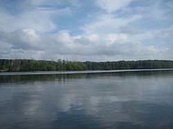
385:
383:
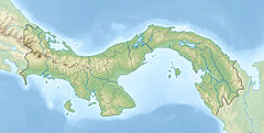
382:
381:
342:
341:
340:
339:
293:
280:
279:
274:Wayback Machine
265:
261:
252:
250:
241:
240:
236:
227:
225:
216:
215:
211:
206:
194:
157:
149:Panama Province
122:
120:
116:
113:
108:
105:
103:
101:
100:
97:
60:
59:
58:
57:
54:
53:
52:
17:
16:River in Panama
12:
11:
5:
390:
388:
380:
379:
374:
369:
364:
359:
357:Gulf of Panama
354:
344:
343:
338:
337:
330:
323:
315:
312:
311:
291:
290:
284:
278:
277:
259:
234:
208:
207:
205:
202:
201:
200:
193:
190:
156:
153:
145:Chepo District
139:is a river of
131:
130:
98:
95:
92:
91:
88:
82:
81:
77:
76:
71:
67:
66:
62:
61:
55:
46:
45:
39:
38:
37:
36:
33:
32:
24:
23:
15:
13:
10:
9:
6:
4:
3:
2:
389:
378:
375:
373:
370:
368:
365:
363:
360:
358:
355:
353:
350:
349:
347:
336:
331:
329:
324:
322:
317:
316:
310:
308:
304:
299:
294:
288:
285:
282:
281:
275:
271:
268:
263:
260:
249:on 2016-07-04
248:
244:
238:
235:
224:on 2012-09-09
223:
219:
213:
210:
203:
199:
196:
195:
191:
189:
187:
183:
180:
178:
173:
171:
166:
162:
154:
152:
150:
146:
142:
138:
127:
99:
93:
89:
87:
83:
78:
75:
72:
68:
63:
43:
34:
30:
25:
20:
307:expanding it
300:
292:
267:Bayano River
262:
251:. Retrieved
247:the original
237:
226:. Retrieved
222:the original
212:
184:
181:
174:
161:Bayano River
158:
136:
134:
172:Mountains.
137:Chepo River
121: /
22:Chepo River
346:Categories
253:2012-04-17
228:2012-04-16
204:References
165:Bayano Dam
109:79°06′49″W
177:tributary
106:8°59′53″N
270:Archived
192:See also
65:Location
289:, 1995.
287:CIA map
186:Coquira
143:in the
70:Country
170:Darien
155:Course
141:Panama
90:
74:Panama
86:Mouth
303:stub
135:The
147:of
348::
334:e
327:t
320:v
309:.
256:.
231:.
Text is available under the Creative Commons Attribution-ShareAlike License. Additional terms may apply.