38:
539:
411:
Cherry is the fruit of the cherry tree. In this region, cherries are ripe in the middle of summer. The term "Cherry" is related to several place names in this area: the pond, the "Cherry River" hamlet, the marsh and the river.
368:
2.0 km southeast in forest zone through Sayat-Nova Pond, to the confluence of
Cuvette Creek (coming from the north and constituting the outlet of "Lac de la Cuvette");
391:
The Cherry River flows to the bottom of a small bay on the Magog Bay on the north shore of Lake
Memphremagog next to Cabana Point in the Deauville area. The
283:
512:
Commission de toponymie du Québec (Quebec place names Board) - Banque de noms de lieux (Place Names Bank) - Place name: "Rivière aux
Cerises"
466:
416:
374:
1.0 km southeastward passing south of the hamlets of Cherry River and Chéribourg, to confluence with Castle Creek (from the north);
174:
502:
Segments of the river measured from the Atlas of Canada (published on the
Internet) of the Department of Natural Resources Canada.
399:. After crossing a small bay, towards the south, the current crosses under the railway bridge located on the north shore of
364:
From the landfill of the "Etang des
Cerises", the Cherry River runs for 11.9 km depending on the following segments:
17:
377:
0.9 km to the south, to the confluence of the "Branche de l'Est" creek, which drains the "Lac à la Truite" upstream;
555:
534:
301:
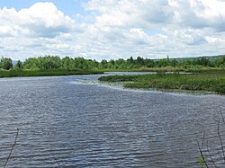
The river was flooded by the creation of dams in the late 19th century, creating a permanent wetland around it.
434:
346:, and Northwest of the center of the village of Cherry River. L'Étang aux Cerises receives the waters from:
321:
560:
392:
511:
454:
481:
400:
396:
328:
271:
160:
384:
63:
415:
The toponym "rivière aux
Cerises" was officially registered on December 5, 1968, at the
428:
275:
129:
37:
549:
380:
4.0 km to the south, parallel to (on the east side) of Red Creek, to
Highway 10;
279:
267:
351:
343:
339:
317:
141:
383:
3.2 km to the mouth of the river, crossing a marsh area, the railway and
338:
The "Cherry River" originates from "Etang aux
Cerises", located south-east of
156:
189:
176:
371:
0.8 km southeast to the "Grand Rocher Creek" (west of the Lynx Peak);
360:
the north, through Mai Creek (which receives the waters of Perdu Creek).
242:
Branche de l'Est (East Branch), ruisseau de la
Cuvette (Cuvette Creek).
43:
295:
291:
287:
100:
90:
80:
535:
Birds observation
Website - Site d'observation des oiseaux du Québec
309:
The main hydrographic slopes adjacent to the "Cherry River" are:
529:
357:
the north slope of the "Hill of Pines" (Colline des Pins);
320:, Red Creek (ruisseau Rouge), Dorman Creek, Meadow Creek,
395:
crosses the "rivière aux Cerises" at its confluence with
354:
by the "Grand Crescent Creek" and the "Billot Creek";
246:
236:
228:
223:
215:
205:
166:
150:
140:
123:
115:
106:
96:
86:
76:
71:
51:
30:
132:(secteur Saint-Élie d'Orford), Étang de la source
530:Official website of the Cherry River Swamp park
274:watershed. This river flows through the cities
8:
55:
542:on Canada Atlas - Natural Resources Canada.
284:Memphremagog Regional County Municipality
16:For other rivers with the same name, see
446:
334:West side: Gagné stream, Montjoie Lake.
27:
342:, south of Fraser Lake, northeast of
313:North side: Key Creek (ruisseau Key);
7:
540:Cherry River (rivière aux Cerises)
286:, in the administrative region of
14:
484:. Townships Heritage Web Magazine
467:Commission de toponymie du Québec
457:Banque de noms de lieux du Québec
417:Commission de toponymie du Québec
36:
482:"The Cherry River Marsh, Magog"
168: • coordinates
1:
107:Physical characteristics
18:Cherry River (disambiguation)
207: • elevation
152: • location
125: • location
577:
15:
459:: Reference number 11964"
252:Ruisseau du Grand Rocher.
136:
111:
35:
435:List of rivers of Quebec
248: • right
350:the northwest slope of
238: • left
25:River in Quebec, Canada
56:
190:45.27028°N 72.17111°W
159:(secteur Deauville),
97:Administrative region
463:toponymie.gouv.qc.ca
322:Saint-François River
270:that is part of the
264:Rivière aux Cerises
224:Basin features
195:45.27028; -72.17111
186: /
57:Rivière aux Cerises
46:in the Cherry River
480:Farfan, Matthew.
401:Lake Memphremagog
397:Lake Memphremagog
329:Lake Memphremagog
272:Lake Memphremagog
256:
255:
161:Lake Memphremagog
568:
556:Rivers of Estrie
528:
514:
509:
503:
500:
494:
493:
491:
489:
477:
471:
470:
451:
431:, a municipality
249:
239:
201:
200:
198:
197:
196:
191:
187:
184:
183:
182:
179:
126:
67:
59:
40:
28:
576:
575:
571:
570:
569:
567:
566:
565:
546:
545:
526:
523:
518:
517:
510:
506:
501:
497:
487:
485:
479:
478:
474:
453:
452:
448:
443:
425:
409:
307:
247:
237:
208:
194:
192:
188:
185:
180:
177:
175:
173:
172:
169:
153:
124:
61:
47:
26:
21:
12:
11:
5:
574:
572:
564:
563:
558:
548:
547:
544:
543:
537:
532:
522:
521:External links
519:
516:
515:
504:
495:
472:
445:
444:
442:
439:
438:
437:
432:
424:
421:
408:
405:
389:
388:
381:
378:
375:
372:
369:
362:
361:
358:
355:
336:
335:
332:
325:
314:
306:
303:
266:is a river in
254:
253:
250:
244:
243:
240:
234:
233:
230:
226:
225:
221:
220:
217:
213:
212:
209:
206:
203:
202:
170:
167:
164:
163:
154:
151:
148:
147:
144:
138:
137:
134:
133:
127:
121:
120:
117:
113:
112:
109:
108:
104:
103:
98:
94:
93:
88:
84:
83:
78:
74:
73:
69:
68:
53:
49:
48:
41:
33:
32:
24:
13:
10:
9:
6:
4:
3:
2:
573:
562:
561:Magog, Quebec
559:
557:
554:
553:
551:
541:
538:
536:
533:
531:
525:
524:
520:
513:
508:
505:
499:
496:
483:
476:
473:
468:
465:(in French).
464:
460:
458:
450:
447:
440:
436:
433:
430:
427:
426:
422:
420:
418:
413:
406:
404:
402:
398:
394:
386:
382:
379:
376:
373:
370:
367:
366:
365:
359:
356:
353:
349:
348:
347:
345:
341:
333:
330:
326:
323:
319:
315:
312:
311:
310:
304:
302:
299:
297:
293:
289:
285:
281:
277:
273:
269:
268:Magog, Quebec
265:
261:
251:
245:
241:
235:
231:
227:
222:
218:
214:
210:
204:
199:
171:
165:
162:
158:
155:
149:
145:
143:
139:
135:
131:
128:
122:
118:
114:
110:
105:
102:
99:
95:
92:
89:
85:
82:
79:
75:
70:
65:
58:
54:
50:
45:
39:
34:
29:
23:
19:
507:
498:
486:. Retrieved
475:
462:
456:
449:
414:
410:
390:
363:
352:Mount Orford
344:Mount Orford
340:Lake Stukely
337:
327:South side:
308:
300:
263:
260:Cherry River
259:
257:
31:Cherry River
22:
527:(in French)
318:Magog River
316:East side:
229:Tributaries
193: /
52:Native name
550:Categories
441:References
181:72°10′16″W
178:45°16′13″N
157:Sherbrooke
393:route 112
385:route 112
305:Geography
282:, in the
44:riverbend
423:See also
407:Toponymy
87:Province
72:Location
488:14 July
278:, then
219:11.9 km
77:Country
429:Orford
296:Canada
292:Quebec
288:Estrie
276:Orford
232:
216:Length
146:
130:Orford
119:
116:Source
101:Estrie
91:Quebec
81:Canada
64:French
60:
294:, in
290:, in
280:Magog
211:204 m
142:Mouth
490:2014
258:The
262:or
552::
461:.
419:.
403:.
298:.
42:A
492:.
469:.
455:"
387:.
331:;
324:;
66:)
62:(
20:.
Text is available under the Creative Commons Attribution-ShareAlike License. Additional terms may apply.