269:
to some of Camden's oldest surviving buildings, especially along Wood and
Pleasant Streets, which were laid out as a subdivision just south of the common. As the town grew, residential development took place along Chestnut Street, resulting in a number of fine mid-19th century Greek Revival and Italianate houses. Camden's earliest summer houses were built at Dillingham Point, marking the southern point of the river's mouth, in the 1880s, and the area now sports several fine Shingle style houses. The point is also where the fine brick 1830s Cape style Ogier house stands; it was built by one of the area's early settlers, and was later transformed into a summer house.
246:
104:
79:
862:
283:
873:
62:
111:
86:
374:
268:
Chestnut Street extends roughly southeast from the town common, which is located just south of the river, and roughly parallels the western bank of the river, above Bay View Road, which provides direct access to the waterfront. Originally farmland in the early days of the town, the area is now home
233:, United States, which represents a cross-section of the town's architectural history, and of its transition from a shipping center to a summer resort community. The district extends south from the town common, along Chestnut Street, and then east to Dillingham Point. It was listed on the
751:
846:
782:
766:
897:
756:
841:
787:
922:
428:
298:
265:. Its early industry was shipbuilding, which was augmented in the mid-19th century by lime quarrying. Both industries declined in the late 19th century, and were eventually replaced by the summer tourist trade.
808:
710:
741:
675:
640:
715:
620:
580:
405:
680:
670:
665:
645:
761:
595:
510:
630:
625:
500:
720:
685:
590:
565:
705:
655:
635:
610:
600:
585:
575:
560:
540:
515:
505:
495:
725:
700:
605:
545:
525:
520:
490:
480:
660:
615:
555:
530:
485:
378:
792:
690:
570:
535:
147:
746:
695:
650:
550:
103:
458:
443:
917:
398:
474:
78:
876:
391:
907:
261:
in the Mid Coast region of coastal Maine. It was first settled in the 1760s, but did not experience significant early development until the 1780s, after the
866:
288:
912:
438:
48:
902:
414:
326:
234:
39:
829:
131:
Chestnut Street from Elm Street to Beacon Avenue, including parts of
Penobscot Avenue, Pleasant and Wood streets, and Dillingham Point
245:
834:
813:
262:
448:
453:
433:
331:
254:
348:
383:
321:
209:
891:
258:
230:
133:
847:
University and college buildings listed on the
National Register of Historic Places
61:
278:
162:
149:
373:
110:
85:
898:
Historic districts on the
National Register of Historic Places in Maine
842:
List of jails and prisons on the
National Register of Historic Places
299:
National
Register of Historic Places listings in Knox County, Maine
322:"National Register Information System – (#91000325)"
244:
387:
923:
National
Register of Historic Places in Knox County, Maine
349:"NRHP nomination for Chestnut Street Historic District"
822:
801:
775:
734:
467:
444:
History of the
National Register of Historic Places
421:
253:The town of Camden is centered on the mouth of the
215:
202:
194:
190:
Multiple, including Cyrus P. Brown, S.G. Ritterbush
186:
178:
141:
127:
475:List of U.S. National Historic Landmarks by state
379:Chestnut Street Historic District (Camden, Maine)
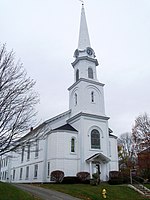
249:The Chestnut Street Baptist Church, November 2010
229:encompasses a predominantly residential part of
867:National Register of Historic Places portal
399:
8:
289:National Register of Historic Places portal
406:
392:
384:
60:
918:Buildings and structures in Camden, Maine
415:U.S. National Register of Historic Places
40:U.S. National Register of Historic Places
16:Historic district in Maine, United States
310:
343:
341:
316:
314:
23:
7:
327:National Register of Historic Places
235:National Register of Historic Places
66:The Camden Post Office, October 2012
908:Greek Revival architecture in Maine
830:National Historic Preservation Act
198:Greek Revival, Queen Anne, Federal
14:
227:Chestnut Street Historic District
32:Chestnut Street Historic District
913:Queen Anne architecture in Maine
872:
871:
860:
372:
281:
109:
102:
84:
77:
783:Federated States of Micronesia
429:Architectural style categories
204:
1:
903:Federal architecture in Maine
118:Show map of the United States
21:United States historic place
939:
835:Historic Preservation Fund
814:American Legation, Morocco
263:American Revolutionary War
855:
776:Lists by associated state
203:NRHP reference
71:
59:
55:
46:
37:
30:
26:
757:Northern Mariana Islands
195:Architectural style
351:. National Park Service
241:Description and history
752:Minor Outlying Islands
735:Lists by insular areas
449:Keeper of the Register
250:
49:U.S. Historic district
454:National Park Service
434:Contributing property
381:at Wikimedia Commons
332:National Park Service
248:
182:60 acres (24 ha)
163:44.20361°N 69.06194°W
809:District of Columbia
257:on the west side of
168:44.20361; -69.06194
159: /
251:
885:
884:
439:Historic district
377:Media related to
255:Megunticook River
223:
222:
93:Show map of Maine
930:
875:
874:
865:
864:
863:
788:Marshall Islands
408:
401:
394:
385:
376:
361:
360:
358:
356:
345:
336:
335:
318:
291:
286:
285:
284:
206:
174:
173:
171:
170:
169:
164:
160:
157:
156:
155:
152:
119:
113:
112:
106:
94:
88:
87:
81:
64:
24:
938:
937:
933:
932:
931:
929:
928:
927:
888:
887:
886:
881:
861:
859:
851:
818:
797:
771:
730:
463:
417:
412:
370:
365:
364:
354:
352:
347:
346:
339:
334:. July 9, 2010.
320:
319:
312:
307:
295:
294:
287:
282:
280:
275:
243:
167:
165:
161:
158:
153:
150:
148:
146:
145:
136:
132:
123:
122:
121:
120:
117:
116:
115:
114:
97:
96:
95:
92:
91:
90:
89:
67:
51:
42:
33:
22:
17:
12:
11:
5:
936:
934:
926:
925:
920:
915:
910:
905:
900:
890:
889:
883:
882:
880:
879:
869:
856:
853:
852:
850:
849:
844:
839:
838:
837:
826:
824:
820:
819:
817:
816:
811:
805:
803:
799:
798:
796:
795:
790:
785:
779:
777:
773:
772:
770:
769:
767:Virgin Islands
764:
759:
754:
749:
744:
742:American Samoa
738:
736:
732:
731:
729:
728:
723:
718:
713:
708:
703:
698:
693:
688:
683:
678:
676:South Carolina
673:
668:
663:
658:
653:
648:
643:
641:North Carolina
638:
633:
628:
623:
618:
613:
608:
603:
598:
593:
588:
583:
578:
573:
568:
563:
558:
553:
548:
543:
538:
533:
528:
523:
518:
513:
508:
503:
498:
493:
488:
483:
478:
471:
469:
468:Lists by state
465:
464:
462:
461:
459:Property types
456:
451:
446:
441:
436:
431:
425:
423:
419:
418:
413:
411:
410:
403:
396:
388:
369:
368:External links
366:
363:
362:
337:
309:
308:
306:
303:
302:
301:
293:
292:
277:
276:
274:
271:
242:
239:
221:
220:
219:March 22, 1991
217:
213:
212:
207:
200:
199:
196:
192:
191:
188:
184:
183:
180:
176:
175:
143:
139:
138:
129:
125:
124:
108:
107:
101:
100:
99:
98:
83:
82:
76:
75:
74:
73:
72:
69:
68:
65:
57:
56:
53:
52:
47:
44:
43:
38:
35:
34:
31:
28:
27:
20:
15:
13:
10:
9:
6:
4:
3:
2:
935:
924:
921:
919:
916:
914:
911:
909:
906:
904:
901:
899:
896:
895:
893:
878:
870:
868:
858:
857:
854:
848:
845:
843:
840:
836:
833:
832:
831:
828:
827:
825:
821:
815:
812:
810:
807:
806:
804:
800:
794:
791:
789:
786:
784:
781:
780:
778:
774:
768:
765:
763:
760:
758:
755:
753:
750:
748:
745:
743:
740:
739:
737:
733:
727:
724:
722:
719:
717:
716:West Virginia
714:
712:
709:
707:
704:
702:
699:
697:
694:
692:
689:
687:
684:
682:
679:
677:
674:
672:
669:
667:
664:
662:
659:
657:
654:
652:
649:
647:
644:
642:
639:
637:
634:
632:
629:
627:
624:
622:
621:New Hampshire
619:
617:
614:
612:
609:
607:
604:
602:
599:
597:
594:
592:
589:
587:
584:
582:
581:Massachusetts
579:
577:
574:
572:
569:
567:
564:
562:
559:
557:
554:
552:
549:
547:
544:
542:
539:
537:
534:
532:
529:
527:
524:
522:
519:
517:
514:
512:
509:
507:
504:
502:
499:
497:
494:
492:
489:
487:
484:
482:
479:
476:
473:
472:
470:
466:
460:
457:
455:
452:
450:
447:
445:
442:
440:
437:
435:
432:
430:
427:
426:
424:
420:
416:
409:
404:
402:
397:
395:
390:
389:
386:
382:
380:
375:
367:
350:
344:
342:
338:
333:
329:
328:
323:
317:
315:
311:
304:
300:
297:
296:
290:
279:
272:
270:
266:
264:
260:
259:Penobscot Bay
256:
247:
240:
238:
236:
232:
231:Camden, Maine
228:
218:
216:Added to NRHP
214:
211:
208:
201:
197:
193:
189:
185:
181:
177:
172:
144:
140:
137:United States
135:
134:Camden, Maine
130:
126:
105:
80:
70:
63:
58:
54:
50:
45:
41:
36:
29:
25:
19:
681:South Dakota
671:Rhode Island
666:Pennsylvania
646:North Dakota
371:
353:. Retrieved
325:
267:
252:
226:
224:
18:
802:Other areas
762:Puerto Rico
596:Mississippi
511:Connecticut
166: /
142:Coordinates
892:Categories
711:Washington
631:New Mexico
626:New Jersey
501:California
305:References
151:44°12′13″N
721:Wisconsin
686:Tennessee
591:Minnesota
566:Louisiana
237:in 1991.
154:69°3′43″W
877:Category
706:Virginia
656:Oklahoma
636:New York
611:Nebraska
601:Missouri
586:Michigan
576:Maryland
561:Kentucky
541:Illinois
516:Delaware
506:Colorado
496:Arkansas
355:March 4,
273:See also
210:91000325
187:Built by
128:Location
823:Related
726:Wyoming
701:Vermont
606:Montana
546:Indiana
526:Georgia
521:Florida
491:Arizona
481:Alabama
661:Oregon
616:Nevada
556:Kansas
531:Hawaii
486:Alaska
422:Topics
793:Palau
691:Texas
571:Maine
536:Idaho
747:Guam
696:Utah
651:Ohio
551:Iowa
357:2016
225:The
179:Area
205:No.
894::
340:^
330:.
324:.
313:^
477::
407:e
400:t
393:v
359:.
Text is available under the Creative Commons Attribution-ShareAlike License. Additional terms may apply.