119:
112:
210:. The highest point on the Guatemala/ El Salvador border is Volcán Chingo at 5,823 feet. It is also known to be the second highest of a group of volcanoes in the SE Guatemala region. The population of people living within 30 km of the Volcán Chingo is estimated to be around 867,678 people. There are no historical eruptions documented for this volcano but it is currently active. The exact volcano number when trying to locate it in the Smithsonian website is 342170.
789:
846:
214:
903:
36:
245:
559:
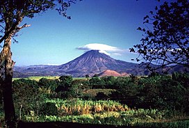
238:. There is a small, oval shaped crater on the summit that is breached towards the west side of the volcano. Different flank fissures have fed many youthful lava flows that can be found West and North of the volcano. There is a light brown hill located below the volcano on the right center side that is known as Cerro Laguneta.
252:
Cerro la Olla, a youthful cone, is located on the South side of the volcano across the
Salvadorian border. A cinder cone that caps the basalt shield, Volcan las Viboras, lies to the North and is the most prominent of several controlled cones in the area.
940:
438:
979:
887:
1004:
830:
989:
933:
431:
974:
306:
trees at the base of the volcano. "Volcán Chingo", the name of the coffee, was farmed in the
Jutiapa Region of Guatemala on the Marcelita Estate.
984:
964:
999:
926:
68:
424:
994:
111:
392:
969:
880:
227:
199:
823:
567:
320:
959:
688:
625:
455:
315:
721:
873:
447:
61:
816:
741:
180:
226:
This symmetrical stratovolcano has many different features that make it stand out to be the highest point on the
673:
523:
513:
643:
605:
528:
168:
610:
615:
262:
600:
548:
478:
241:
The different rock types that can be found are
Andesite/ Basaltic Andesite and Basalt/ Picro-Basalt.
152:
585:
575:
538:
518:
533:
759:
706:
406:
144:
493:
749:
731:
595:
488:
468:
910:
857:
800:
701:
678:
590:
503:
726:
716:
498:
293:
on the Volcán Chingo, ecologists speculate there could be other populations in the area.
696:
658:
296:
The valley underneath the
Volcano chingo is home to nutrient rich soil perfect to grow
788:
953:
195:
173:
17:
648:
213:
853:
638:
543:
302:
297:
278:
270:
235:
207:
156:
902:
845:
354:
340:
754:
463:
416:
83:
70:
796:
668:
473:
378:
286:
267:
231:
203:
148:
35:
244:
711:
663:
633:
483:
653:
558:
508:
51:
243:
212:
909:
This article related to a protected area in North
America is a
420:
300:. Peregrine Roasters grows coffee beans in the shade under
771:
Note: volcanoes are ordered from north-west to south-east.
914:
861:
804:
131:
Location in
Guatemala, on the border with El Salvador
217:
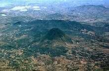
This aerial view is from the SW, the
Guatemala side.
740:
687:
624:
566:
454:
179:
167:
162:
140:
99:
60:
50:
45:
28:
359:Smithsonian Institution | Global Volcanism Program
341:"Smithsonian Institution Global Volcanism Project"
23:Stratovolcano between El Salvador and Guatemala
934:
881:
824:
432:
393:"The elusive Sobralia amabilis (Orchidaceae)"
8:
285:and was the only recorded sighting in local
941:
927:
888:
874:
831:
817:
439:
425:
417:
25:
980:International mountains of North America
332:
118:
7:
899:
897:
842:
840:
785:
783:
266:is an elusive flower located in the
1005:North American protected area stubs
407:"Guatemala Volcán Chingo Peregrine"
355:"Global Volcanism Program | Chingo"
913:. You can help Knowledge (XXG) by
860:. You can help Knowledge (XXG) by
803:. You can help Knowledge (XXG) by
14:
281:" was registered near the top of
901:
844:
787:
557:
379:"Chingo (Guatemala-El Salvador)"
321:List of volcanoes in El Salvador
117:
110:
34:
289:. Based on the findings of the
975:Stratovolcanoes of El Salvador
316:List of volcanoes in Guatemala
1:
990:El Salvador–Guatemala border
985:Stratovolcanoes of Guatemala
965:Protected areas of Guatemala
56:1,775 m (5,823 ft)
1000:El Salvador geography stubs
1021:
896:
839:
782:
448:Central American volcanoes
15:
995:Guatemala geography stubs
768:
555:
104:
33:
970:Mountains of El Salvador
514:Santa María/Santiaguito
960:Mountains of Guatemala
856:location article is a
799:location article is a
249:
218:
247:
216:
84:14.12000°N 89.73000°W
16:For the rapper, see
89:14.12000; -89.73000
80: /
722:Rincón de la Vieja
250:
219:
46:Highest point
922:
921:
869:
868:
812:
811:
777:
776:
772:
489:Cuilapa-Barbarena
291:Sobralia amabilis
275:Sobralia amabilis
263:Sobralia amabilis
189:
188:
1012:
943:
936:
929:
905:
898:
890:
883:
876:
848:
841:
833:
826:
819:
791:
784:
770:
561:
441:
434:
427:
418:
411:
410:
403:
397:
396:
389:
383:
382:
375:
369:
368:
366:
365:
351:
345:
344:
337:
121:
120:
114:
95:
94:
92:
91:
90:
85:
81:
78:
77:
76:
73:
38:
26:
1020:
1019:
1015:
1014:
1013:
1011:
1010:
1009:
950:
949:
948:
947:
895:
894:
838:
837:
780:
778:
773:
764:
736:
683:
620:
562:
553:
450:
445:
415:
414:
405:
404:
400:
391:
390:
386:
377:
376:
372:
363:
361:
353:
352:
348:
339:
338:
334:
329:
312:
259:
224:
151:
136:
135:
134:
133:
132:
129:
128:
127:
126:
122:
88:
86:
82:
79:
74:
71:
69:
67:
66:
41:
24:
21:
12:
11:
5:
1018:
1016:
1008:
1007:
1002:
997:
992:
987:
982:
977:
972:
967:
962:
952:
951:
946:
945:
938:
931:
923:
920:
919:
906:
893:
892:
885:
878:
870:
867:
866:
849:
836:
835:
828:
821:
813:
810:
809:
792:
775:
774:
769:
766:
765:
763:
762:
757:
752:
746:
744:
738:
737:
735:
734:
729:
724:
719:
714:
709:
704:
699:
693:
691:
685:
684:
682:
681:
676:
671:
666:
661:
656:
651:
646:
641:
636:
630:
628:
622:
621:
619:
618:
613:
608:
603:
598:
593:
588:
583:
578:
572:
570:
564:
563:
556:
554:
552:
551:
546:
541:
536:
531:
526:
521:
516:
511:
506:
501:
496:
491:
486:
481:
476:
471:
466:
460:
458:
452:
451:
446:
444:
443:
436:
429:
421:
413:
412:
398:
384:
370:
346:
331:
330:
328:
325:
324:
323:
318:
311:
308:
258:
255:
223:
220:
187:
186:
183:
177:
176:
171:
165:
164:
160:
159:
142:
138:
137:
130:
124:
123:
116:
115:
109:
108:
107:
106:
105:
102:
101:
97:
96:
64:
58:
57:
54:
48:
47:
43:
42:
40:Chingo in 1999
39:
31:
30:
22:
13:
10:
9:
6:
4:
3:
2:
1017:
1006:
1003:
1001:
998:
996:
993:
991:
988:
986:
983:
981:
978:
976:
973:
971:
968:
966:
963:
961:
958:
957:
955:
944:
939:
937:
932:
930:
925:
924:
918:
916:
912:
907:
904:
900:
891:
886:
884:
879:
877:
872:
871:
865:
863:
859:
855:
850:
847:
843:
834:
829:
827:
822:
820:
815:
814:
808:
806:
802:
798:
793:
790:
786:
781:
767:
761:
758:
756:
753:
751:
748:
747:
745:
743:
739:
733:
730:
728:
725:
723:
720:
718:
715:
713:
710:
708:
705:
703:
700:
698:
695:
694:
692:
690:
686:
680:
677:
675:
674:San Cristóbal
672:
670:
667:
665:
662:
660:
657:
655:
652:
650:
647:
645:
642:
640:
637:
635:
632:
631:
629:
627:
623:
617:
614:
612:
609:
607:
604:
602:
599:
597:
594:
592:
589:
587:
584:
582:
579:
577:
574:
573:
571:
569:
565:
560:
550:
547:
545:
542:
540:
537:
535:
532:
530:
527:
525:
522:
520:
517:
515:
512:
510:
507:
505:
502:
500:
497:
495:
492:
490:
487:
485:
482:
480:
477:
475:
472:
470:
467:
465:
462:
461:
459:
457:
453:
449:
442:
437:
435:
430:
428:
423:
422:
419:
408:
402:
399:
394:
388:
385:
380:
374:
371:
360:
356:
350:
347:
342:
336:
333:
326:
322:
319:
317:
314:
313:
309:
307:
305:
304:
299:
294:
292:
288:
284:
283:Volcán Chingo
280:
276:
272:
269:
265:
264:
256:
254:
248:Cerro La Olla
246:
242:
239:
237:
233:
229:
221:
215:
211:
209:
205:
201:
197:
196:stratovolcano
193:
192:Volcán Chingo
184:
182:
181:Last eruption
178:
175:
174:Stratovolcano
172:
170:
169:Mountain type
166:
161:
158:
154:
150:
146:
143:
139:
125:Volcán Chingo
113:
103:
98:
93:
65:
63:
59:
55:
53:
49:
44:
37:
32:
29:Volcán Chingo
27:
19:
915:expanding it
908:
862:expanding it
851:
805:expanding it
794:
779:
606:San Salvador
580:
529:Siete Orejas
401:
387:
373:
362:. Retrieved
358:
349:
335:
301:
298:coffee beans
295:
290:
282:
274:
273:region. The
261:
260:
251:
240:
225:
191:
190:
18:Chingo Bling
854:El Salvador
639:Cerro Negro
611:San Vicente
568:El Salvador
544:Tecuamburro
524:Santo Tomás
303:Inga edulis
279:Orchidaceae
271:El Salvador
236:El Salvador
208:El Salvador
157:El Salvador
87: /
62:Coordinates
954:Categories
755:La Yeguada
707:Miravalles
689:Costa Rica
644:Concepción
601:San Miguel
464:Acatenango
364:2022-01-23
327:References
75:89°43′48″W
72:14°07′12″N
797:Guatemala
732:Turrialba
669:Momotombo
649:Cosigüina
626:Nicaragua
596:Santa Ana
586:Conchagua
576:Chinameca
539:Tajumulco
519:San Pedro
474:Almolonga
456:Guatemala
287:Guatemala
268:Guatemala
257:Ecosystem
232:Guatemala
204:Guatemala
153:Santa Ana
149:Guatemala
100:Geography
52:Elevation
760:El Valle
712:Platanar
664:Mombacho
634:Apoyeque
616:Usulután
484:Chicabal
310:See also
230:between
202:between
141:Location
727:Tenorio
654:Maderas
549:Tolimán
479:Atitlán
222:Geology
198:on the
185:Unknown
163:Geology
145:Jutiapa
742:Panama
697:Arenal
679:Telica
659:Masaya
591:Izalco
581:Chingo
534:Tacaná
509:Pacaya
504:Moyuta
228:border
200:border
852:This
795:This
702:Irazú
499:Jumay
494:Fuego
194:is a
911:stub
858:stub
801:stub
750:Barú
717:Poás
469:Agua
277:of "
234:and
206:and
956::
357:.
155:,
147:,
942:e
935:t
928:v
917:.
889:e
882:t
875:v
864:.
832:e
825:t
818:v
807:.
440:e
433:t
426:v
409:.
395:.
381:.
367:.
343:.
20:.
Text is available under the Creative Commons Attribution-ShareAlike License. Additional terms may apply.