221:
20:
42:, United States. It is one of the steepest canyons in North America, dropping from over 8,500 feet (2,600 m) at the south rim to less than 2,700 feet (820 m) on the valley floor in less than a mile. The
46:
was built in the canyon in 1963 to quickly transport people from the valley floor to the top of the mountain. After it was redesigned in 2000, it became the largest rotating aerial tramway in the world.
347:
119:
that peaks out at about 5.4 ft per second (0.15 m per second). The stream flows under the Aerial
Tramway Valley Station and later dries up about 3.5 miles down the canyon.
262:
332:
327:
308:
124:
337:
255:
342:
182:
301:
248:
352:
93:
294:
90:
59:
228:
67:
63:
39:
86:
43:
24:
220:
206:
51:
108:
186:
82:
55:
278:
232:
168:
321:
71:
75:
139:
126:
183:"10257720 Chino Canyon Creek Below Tramway, Near Palm Springs, Ca - 1998 Wy"
112:
19:
207:
U.S. Geological Survey
Geographic Names Information System: Chino Canyon
116:
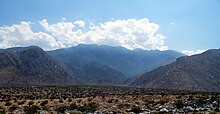
96:
35:
18:
282:
236:
277:This article related to a river in California is a
62:. The upper reaches of the canyon are bordered by
50:The canyon is located in the northern end of the
58:. Its associated stream is a tributary of the
70:, and is being encroached by the outskirts of
302:
256:
8:
348:Riverside County, California geography stubs
309:
295:
263:
249:
333:Landforms of Riverside County, California
169:"Palm Springs Aerial Tramway - DesertUSA"
81:In 1942, Chino Canyon was the site of a
34:is a 5.5-mile-long (8.9 km) desert
160:
107:Chino Canyon is a desert canyon fed by
328:Rivers of Riverside County, California
66:, while the lower end terminates near
7:
274:
272:
217:
215:
27:, as observed from Palm Canyon Drive
14:
338:Canyons and gorges of California
219:
54:at the northwestern end of the
1:
343:Rivers of Southern California
91:United States Army Air Forces
281:. You can help Knowledge by
235:. You can help Knowledge by
229:Riverside County, California
68:California State Highway 111
64:Mount San Jacinto State Park
40:Riverside County, California
87:American Airlines Flight 28
44:Palm Springs Aerial Tramway
16:Desert canyon in California
369:
271:
214:
25:Palm Springs, California
353:California river stubs
231:-related article is a
140:33.86444°N 116.57111°W
28:
52:San Jacinto Mountains
22:
145:33.86444; -116.57111
136: /
111:. These produce a
103:Chino Canyon Creek
29:
290:
289:
244:
243:
83:mid-air collision
360:
311:
304:
297:
273:
265:
258:
251:
223:
216:
209:
204:
198:
197:
195:
194:
185:. Archived from
179:
173:
172:
165:
151:
150:
148:
147:
146:
141:
137:
134:
133:
132:
129:
60:Whitewater River
56:Coachella Valley
368:
367:
363:
362:
361:
359:
358:
357:
318:
317:
316:
315:
270:
269:
213:
212:
205:
201:
192:
190:
181:
180:
176:
167:
166:
162:
157:
144:
142:
138:
135:
130:
127:
125:
123:
122:
105:
17:
12:
11:
5:
366:
364:
356:
355:
350:
345:
340:
335:
330:
320:
319:
314:
313:
306:
299:
291:
288:
287:
268:
267:
260:
253:
245:
242:
241:
224:
211:
210:
199:
174:
159:
158:
156:
153:
104:
101:
15:
13:
10:
9:
6:
4:
3:
2:
365:
354:
351:
349:
346:
344:
341:
339:
336:
334:
331:
329:
326:
325:
323:
312:
307:
305:
300:
298:
293:
292:
286:
284:
280:
275:
266:
261:
259:
254:
252:
247:
246:
240:
238:
234:
230:
225:
222:
218:
208:
203:
200:
189:on 2008-09-16
188:
184:
178:
175:
170:
164:
161:
154:
152:
149:
120:
118:
114:
110:
102:
100:
98:
95:
92:
88:
84:
79:
77:
73:
69:
65:
61:
57:
53:
48:
45:
41:
37:
33:
26:
23:Chino Canyon
21:
283:expanding it
276:
237:expanding it
226:
202:
191:. Retrieved
187:the original
177:
163:
121:
106:
80:
72:Palm Springs
49:
32:Chino Canyon
31:
30:
143: /
131:116°34′16″W
322:Categories
193:2008-08-24
128:33°51′52″N
76:California
113:waterfall
85:between
109:springs
117:stream
115:and a
97:bomber
89:and a
36:canyon
227:This
155:Notes
279:stub
233:stub
94:B-34
78:.
38:in
324::
99:.
74:,
310:e
303:t
296:v
285:.
264:e
257:t
250:v
239:.
196:.
171:.
Text is available under the Creative Commons Attribution-ShareAlike License. Additional terms may apply.