34:
105:
112:
332:
until the confluence of the Chikoy and
Chikokon rivers. The maximum width of the range is 40 kilometers (25 mi). The main summits of the Chikokon Range reach heights between 2,000 meters (6,600 ft) and 2,200 meters (7,200 ft). The highest point is 2,519 meters (8,264 ft) high
33:
104:
161:
490:
341:
type summit which is also the highest point of the
Khentei-Daur Highlands. Spurs extending from the Chikokon Range connect with the
495:
275:
154:
322:
294:
200:
298:
374:
282:
342:
222:
346:
338:
334:
328:
The mountain chain stretches roughly northeastwards for over 130 kilometers (81 mi) from
55:
147:
310:
252:
193:
484:
461:
450:
314:
268:
39:
472:
256:
401:
306:
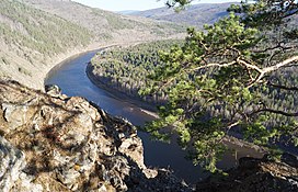
267:. The range is named after the Chikokon River, a small left tributary of the
176:
163:
278:
228:
301:. It rises in the interfluve of the Chikoy River, a right tributary of the
329:
232:
210:
318:
302:
260:
325:
in the form of sediments are present in certain places of the range.
264:
137:
62:
358:
321:
oceans. The relief is characterized by steep slopes. Traces of
404:[Chikokon Range] (in Russian). Энциклопедия Забайкалья
357:
The slopes of the range are mainly covered with mountain
426:
361:
and pre-Alpine forest. The higher parts are topped by
221:
216:
206:
192:
153:
143:
133:
92:
84:
76:
71:
61:
51:
46:
21:
462:Topographic map sheet M-49-XXI . Scale: 1: 200 000
473:Topographic map sheet M-49-XV . Scale: 1: 200 000
274:The Chikokon Range is within the limits of the
246:
8:
18:
309:. The southern part of the ridge acts as
386:
111:
396:
394:
392:
390:
285:is located in the area of the range.
7:
293:The Chikokon Range is part of the
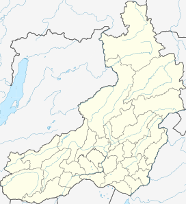
124:Location in the Transbaikal region
80:130 km (81 mi) NE/SW
14:
88:40 km (25 mi) SE/NW
16:Mountain range in Siberia, Russia
110:
103:
32:
305:, and some tributaries of the
1:
259:Region (Zabaykalsky Krai) of
276:Trans-Baikal conifer forests
67:2,519 m (8,264 ft)
512:
491:Mountain ranges of Russia
247:
97:
31:
26:
496:Khentei-Daur Highlands
429:. Chikoy National Park
427:"Chikoy National Park"
323:Pleistocene glaciation
295:Khentei-Daur Highlands
201:Khentei-Daur Highlands
299:South Siberian System
402:"Чикоконский хребет"
375:Chikoy National Park
283:Chikoy National Park
38:Upper course of the
365:type bare summits.
173: /
248:Чикоконский хребет
177:49.600°N 110.000°E
47:Highest point
27:Чикоконский хребет
335:Bystrinsky Golets
239:
238:
155:Range coordinates
56:Bystrinsky Golets
503:
475:
470:
464:
459:
453:
448:
442:
441:
438:
436:
434:
423:
417:
416:
413:
411:
409:
398:
250:
249:
196:
188:
187:
185:
184:
183:
178:
174:
171:
170:
169:
166:
148:Zabaykalsky Krai
114:
113:
107:
36:
19:
511:
510:
506:
505:
504:
502:
501:
500:
481:
480:
479:
478:
471:
467:
460:
456:
449:
445:
439:
432:
430:
425:
424:
420:
414:
407:
405:
400:
399:
388:
383:
371:
355:
291:
194:
182:49.600; 110.000
181:
179:
175:
172:
167:
164:
162:
160:
159:
129:
128:
127:
126:
125:
122:
121:
120:
119:
115:
42:
17:
12:
11:
5:
509:
507:
499:
498:
493:
483:
482:
477:
476:
465:
454:
443:
418:
385:
384:
382:
379:
378:
377:
370:
367:
354:
351:
290:
287:
253:mountain range
245:(Russian:
243:Chikokon Range
237:
236:
225:
219:
218:
214:
213:
208:
204:
203:
198:
190:
189:
157:
151:
150:
145:
141:
140:
135:
131:
130:
123:
118:Chikokon Range
117:
116:
109:
108:
102:
101:
100:
99:
98:
95:
94:
90:
89:
86:
82:
81:
78:
74:
73:
69:
68:
65:
59:
58:
53:
49:
48:
44:
43:
37:
29:
28:
24:
23:
22:Chikokon Range
15:
13:
10:
9:
6:
4:
3:
2:
508:
497:
494:
492:
489:
488:
486:
474:
469:
466:
463:
458:
455:
452:
447:
444:
428:
422:
419:
403:
397:
395:
393:
391:
387:
380:
376:
373:
372:
368:
366:
364:
360:
352:
350:
348:
344:
340:
336:
331:
326:
324:
320:
316:
312:
308:
304:
300:
296:
288:
286:
284:
280:
277:
272:
270:
266:
262:
258:
254:
244:
234:
230:
226:
224:
220:
215:
212:
209:
205:
202:
199:
197:
191:
186:
158:
156:
152:
149:
146:
142:
139:
136:
132:
106:
96:
91:
87:
83:
79:
75:
70:
66:
64:
60:
57:
54:
50:
45:
41:
35:
30:
25:
20:
468:
457:
451:Google Earth
446:
440:(in Russian)
431:. Retrieved
421:
415:(in Russian)
406:. Retrieved
362:
356:
327:
313:between the
292:
273:
269:Chikoy River
242:
240:
195:Parent range
40:Chikoy River
257:Transbaikal
223:Age of rock
180: /
485:Categories
433:5 February
408:5 February
381:References
307:Onon River
207:Borders on
72:Dimensions
311:watershed
289:Geography
279:ecoregion
231:(NE) and
229:Paleozoic
93:Geography
63:Elevation
369:See also
363:"golets"
349:ranges.
339:"golets"
330:Mongolia
233:Jurassic
211:Mongolia
343:Pereval
319:Pacific
303:Selenga
261:Siberia
255:in the
251:) is a
217:Geology
168:110°0′E
165:49°36′N
134:Country
347:Burkal
315:Arctic
281:. The
265:Russia
138:Russia
77:Length
359:taiga
353:Flora
227:Late
85:Width
435:2020
410:2020
345:and
337:, a
317:and
241:The
235:(SW)
144:Krai
52:Peak
271:.
487::
389:^
297:,
263:,
437:.
412:.
Text is available under the Creative Commons Attribution-ShareAlike License. Additional terms may apply.