40:
32:
20:
212:
268:
249:
176:
79:
242:
278:
235:
90:
75:
39:
101:, means most of the buildings date from the twentieth century. In the modern era it is known for the
83:
273:
63:
59:
31:
19:
94:
219:
98:
262:
24:
71:
67:
55:
211:
51:
191:
178:
97:
the area was badly bombed and was heavily redeveloped which, along with
38:
30:
18:
43:
The old St Mary's Church from which the street gets its name.
218:
This London road or road transport-related article is a
223:
243:
8:
82:, from which the street gets its name. The
250:
236:
86:electoral ward is named after the street.
159:Cherry, Bridget & Pevsner, Nikolaus.
114:
166:Kershman, Andrew & Ireson, Ally.
7:
208:
206:
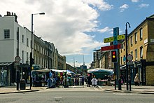
23:Church Street looking west towards
269:Streets in the City of Westminster
70:on a south west diagonal crossing
14:
210:
163:. Yale University Press, 2002.
1:
93:was located here. During the
222:. You can help Knowledge by
170:. Metro Publications, 2000.
295:
205:
139:Kershman & Ireson p.58
130:Cherry & Pevsner p.662
91:Theatre Royal, Marylebone
168:The London Market Guide
89:The nineteenth century
44:
36:
28:
152:Bebbington, Gillian.
50:is a thoroughfare in
42:
35:Church Street Market.
34:
22:
192:51.52284°N 0.17118°W
161:London 3: North West
103:Church Street Market
58:, and is within the
188: /
154:London Street Names
64:City of Westminster
197:51.52284; -0.17118
121:Bebbington p.86-87
60:West End of London
45:
37:
29:
279:London road stubs
231:
230:
156:. Batsford, 1972.
74:and finishing at
62:. Located in the
286:
252:
245:
238:
214:
207:
203:
202:
200:
199:
198:
193:
189:
186:
185:
184:
181:
140:
137:
131:
128:
122:
119:
95:Second World War
80:St Mary's Church
76:Paddington Green
16:Street in London
294:
293:
289:
288:
287:
285:
284:
283:
259:
258:
257:
256:
196:
194:
190:
187:
182:
179:
177:
175:
174:
149:
144:
143:
138:
134:
129:
125:
120:
116:
111:
78:and the nearby
66:, it runs from
17:
12:
11:
5:
292:
290:
282:
281:
276:
271:
261:
260:
255:
254:
247:
240:
232:
229:
228:
215:
172:
171:
164:
157:
148:
145:
142:
141:
132:
123:
113:
112:
110:
107:
99:slum clearance
15:
13:
10:
9:
6:
4:
3:
2:
291:
280:
277:
275:
272:
270:
267:
266:
264:
253:
248:
246:
241:
239:
234:
233:
227:
225:
221:
216:
213:
209:
204:
201:
169:
165:
162:
158:
155:
151:
150:
146:
136:
133:
127:
124:
118:
115:
108:
106:
104:
100:
96:
92:
87:
85:
84:Church Street
81:
77:
73:
69:
65:
61:
57:
54:, located in
53:
49:
48:Church Street
41:
33:
26:
25:Edgeware Road
21:
224:expanding it
217:
173:
167:
160:
153:
147:Bibliography
135:
126:
117:
102:
88:
72:Edgware Road
68:Lisson Grove
47:
46:
195: /
56:West London
274:Marylebone
263:Categories
180:51°31′22″N
109:References
52:Marylebone
183:0°10′16″W
220:stub
265::
105:.
251:e
244:t
237:v
226:.
27:.
Text is available under the Creative Commons Attribution-ShareAlike License. Additional terms may apply.