68:
411:
468:
43:
75:
50:
29:
375:
312:
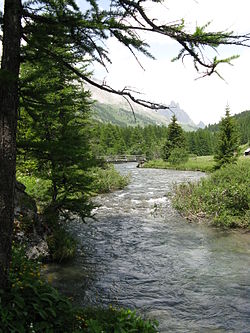
is visited by cyclists, walkers and horse riders. The river is used for water sports especially in spring as the snow melts. There are sections of white water, which are used by kayaks and white water rafts. There is a dramatic waterfall at
Fontcouverte.
67:
599:
509:
589:
604:
502:
555:
452:
495:
283:
department. Its confluence with the
Durance is near the hamlet of Les Alberts not far from the source of the Durance in the ski resort of
574:
179:
418:
42:
584:
548:
445:
609:
594:
541:
438:
290:
The upper reaches of the river are in a military exercise range. This is where the French army from their base in
579:
410:
355:
309:
303:
475:
392:
379:
467:
243:
337:
525:
479:
422:
264:
568:
280:
268:
129:
291:
284:
272:
150:
325:
194:
181:
276:
239:
260:
235:
165:
256:
100:
28:
267:
is 189 km (73 sq mi). Its source is in the
395:, Observatoire Régional Eau et Milieux Aquatiques en PACA
529:
483:
426:
231:
226:
218:
210:
171:
159:
149:
135:
123:
115:
106:
96:
91:
21:
524:This article related to a river in France is a
263:. It is 31.9 km (19.8 mi) long. Its
549:
503:
446:
8:
600:Provence-Alpes-Côte d'Azur geography stubs
556:
542:
510:
496:
453:
439:
380:"Fiche cours d'eau - La Clarée (X0000500)"
321:The settlements along the Clarée include:
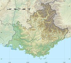
279:. It flows for all of its course in the
367:
82:Show map of Provence-Alpes-Côte d'Azur
18:
7:
605:Auvergne-Rhône-Alpes geography stubs
590:Rivers of Provence-Alpes-Côte d'Azur
521:
519:
464:
462:
407:
405:
14:
393:Bassin versant : Clarée (La)
466:
409:
222:189 km (73 sq mi)
73:
66:
48:
41:
27:
173: • coordinates
74:
49:
1:
107:Physical characteristics
528:. You can help Knowledge by
482:. You can help Knowledge by
425:. You can help Knowledge by
141:2,200 m (7,200 ft)
137: • elevation
259:, a right tributary to the
255:is a river in southeastern
161: • location
125: • location
626:
575:Tributaries of the Durance
518:
478:geographical article is a
461:
419:Provence-Alpes-Côte d'Azur
404:
301:
145:
111:
35:
26:
294:train in the mountains.
421:geography article is a
214:32 km (20 mi)
585:Rivers of Hautes-Alpes
476:Auvergne-Rhône-Alpes
356:Vallée de la Clarée
310:Vallée de la Clarée
304:Vallée de la Clarée
227:Basin features
191: /
610:France river stubs
595:Rivers of the Alps
308:In the summer the
195:44.9246°N 6.6795°E
57:Show map of France
537:
536:
491:
490:
434:
433:
249:
248:
244:Mediterranean Sea
617:
580:Rivers of France
558:
551:
544:
520:
512:
505:
498:
470:
463:
455:
448:
441:
413:
406:
396:
390:
384:
383:
372:
206:
205:
203:
202:
201:
196:
192:
189:
188:
187:
184:
138:
126:
83:
77:
76:
70:
58:
52:
51:
45:
31:
19:
625:
624:
620:
619:
618:
616:
615:
614:
565:
564:
563:
562:
517:
516:
460:
459:
402:
400:
399:
391:
387:
374:
373:
369:
364:
352:
319:
306:
300:
200:44.9246; 6.6795
199:
197:
193:
190:
185:
182:
180:
178:
177:
174:
162:
136:
124:
87:
86:
85:
84:
81:
80:
79:
78:
61:
60:
59:
56:
55:
54:
53:
17:
16:River in France
12:
11:
5:
623:
621:
613:
612:
607:
602:
597:
592:
587:
582:
577:
567:
566:
561:
560:
553:
546:
538:
535:
534:
515:
514:
507:
500:
492:
489:
488:
471:
458:
457:
450:
443:
435:
432:
431:
414:
398:
397:
385:
366:
365:
363:
360:
359:
358:
351:
348:
347:
346:
343:
340:
335:
332:
329:
318:
315:
302:Main article:
299:
296:
265:drainage basin
247:
246:
233:
229:
228:
224:
223:
220:
216:
215:
212:
208:
207:
175:
172:
169:
168:
163:
160:
157:
156:
153:
147:
146:
143:
142:
139:
133:
132:
127:
121:
120:
117:
113:
112:
109:
108:
104:
103:
98:
94:
93:
89:
88:
72:
71:
65:
64:
63:
62:
47:
46:
40:
39:
38:
37:
36:
33:
32:
24:
23:
15:
13:
10:
9:
6:
4:
3:
2:
622:
611:
608:
606:
603:
601:
598:
596:
593:
591:
588:
586:
583:
581:
578:
576:
573:
572:
570:
559:
554:
552:
547:
545:
540:
539:
533:
531:
527:
522:
513:
508:
506:
501:
499:
494:
493:
487:
485:
481:
477:
472:
469:
465:
456:
451:
449:
444:
442:
437:
436:
430:
428:
424:
420:
415:
412:
408:
403:
394:
389:
386:
381:
377:
371:
368:
361:
357:
354:
353:
349:
344:
341:
339:
336:
333:
330:
327:
324:
323:
322:
316:
314:
311:
305:
297:
295:
293:
288:
286:
282:
278:
274:
270:
266:
262:
258:
254:
245:
241:
237:
234:
230:
225:
221:
217:
213:
209:
204:
176:
170:
167:
164:
158:
154:
152:
148:
144:
140:
134:
131:
128:
122:
118:
114:
110:
105:
102:
99:
95:
90:
69:
44:
34:
30:
25:
20:
530:expanding it
523:
484:expanding it
473:
427:expanding it
416:
401:
388:
370:
338:Val-des-Prés
320:
307:
289:
281:Hautes-Alpes
269:Cottian Alps
252:
250:
130:Cottian Alps
345:Les Alberts
317:Settlements
285:Montgenevre
273:Mont Thabor
232:Progression
198: /
569:Categories
362:References
219:Basin size
183:44°55′29″N
342:Le Rosier
331:Plampinet
186:6°40′46″E
350:See also
334:Le Serre
292:Briançon
277:Valloire
92:Location
326:Névache
298:Tourism
271:, near
261:Durance
236:Durance
166:Durance
97:Country
376:Sandre
257:France
253:Clarée
211:Length
155:
119:
116:Source
101:France
22:Clarée
474:This
417:This
240:Rhône
151:Mouth
526:stub
480:stub
423:stub
275:and
251:The
571::
378:.
287:.
242:→
238:→
557:e
550:t
543:v
532:.
511:e
504:t
497:v
486:.
454:e
447:t
440:v
429:.
382:.
328::
Text is available under the Creative Commons Attribution-ShareAlike License. Additional terms may apply.