29:
94:
664:
415:
669:
319:
The high elevation of the mountain means that snow falls on the high peaks during the winter, although the mountain receives little precipitation annually.
331:
area developed by Randy
Leavitt in 1992. It has been described as containing the best limestone climbing in America and includes the world's first-ever
674:
620:
59:
419:
659:
639:
134:
537:
499:
168:
466:
411:
87:
239:
585:
235:
380:
243:
215:
195:
28:
493:
67:
301:
359:
211:
156:
590:
293:
188:
77:
260:(part of Path 46) 500 kV power lines run to the north and south of the mountain, respectively.
635:
616:
277:
403:
364:
332:
285:
38:
163:
541:
368:
309:
149:
653:
563:
328:
247:
142:
34:
521:
336:
242:
to an elevation of 7,933 ft (2,418 m), which is the highest point of the
181:
473:
632:
Desert
Summits: A Climbing & Hiking Guide to California and Southern Nevada
439:
341:
273:
269:
219:
191:
138:
109:
96:
346:
207:
257:
253:
223:
52:
586:"Séb Bouin Just Established the Hardest Route in America (5.15c)"
615:(4th ed.). Medford, OR: Benchmark Maps. 2005. p. 97.
292:) forests grow on the foothills of the mountain while
272:
contrast to the lower elevations of the Mojave Desert
268:
The higher elevations of the mountain are a striking
316:) grow on the sky island at the highest elevations.
33:
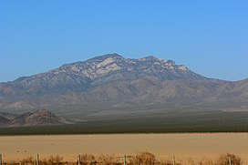
The mountain is prominently visible to motorists on
180:
175:
162:
148:
130:
125:
86:
76:
66:
51:
46:
21:
538:"Subsection 322Aj - Kingston Range - Valley Wells"
564:"Clark Mountain - the best limestone in America"
416:National Oceanic and Atmospheric Administration
665:Mountains of San Bernardino County, California
8:
18:
498:(Map). 1:24000. 7.5 Minute Topographic.
392:
613:California road & recreation atlas
540:. USDA, Forest Service. Archived from
495:Clark Mountain quadrangle, California
461:
459:
398:
396:
327:Clark Mountain is also a world-class
234:The mountain rises abruptly north of
16:Mountain in California, United States
7:
670:Natural history of the Mojave Desert
532:
530:
517:
515:
420:United States Department of Commerce
584:Walsh, Anthony (3 November 2022).
367: (5.15c), became the hardest
14:
634:. Bishop, CA: Spotted Dog Press.
675:Mountains of Southern California
345:(2008). In 2022, French climber
27:
110:35.525569794°N 115.588717936°W
1:
440:"Clark Mountain, California"
115:35.525569794; -115.588717936
72:4,232 ft (1,290 m)
57:7,933 ft (2,418 m)
467:"Desert Peaks Section List"
691:
82:Desert Peaks Section List
26:
660:Mojave National Preserve
412:National Geodetic Survey
381:Mojave National Preserve
244:Mojave National Preserve
216:Mojave National Preserve
294:single-leaf pinyon pine
335: (5.15b) route,
306:Juniperus osteosperma
135:San Bernardino County
212:Clark Mountain Range
157:Clark Mountain Range
630:Zdon, Andy (2000).
472:. Angeles Chapter,
106: /
371:in North America.
360:Suprême Jumbo Love
60: NAVD 88
47:Highest point
622:978-0-929591-80-3
282:Larrea tridentata
201:
200:
62:
682:
645:
626:
603:
602:
600:
598:
581:
575:
574:
572:
571:
566:. UKClimbing.com
562:Leavitt, Randy.
559:
553:
552:
550:
549:
534:
525:
519:
510:
509:
507:
506:
490:
484:
483:
481:
480:
471:
463:
454:
453:
451:
450:
436:
430:
429:
427:
426:
400:
298:Pinus monophylla
290:Yucca brevifolia
184:
152:
121:
120:
118:
117:
116:
111:
107:
104:
103:
102:
99:
58:
39:Ivanpah Dry Lake
31:
19:
690:
689:
685:
684:
683:
681:
680:
679:
650:
649:
648:
642:
629:
623:
611:
607:
606:
596:
594:
583:
582:
578:
569:
567:
561:
560:
556:
547:
545:
536:
535:
528:
520:
513:
504:
502:
492:
491:
487:
478:
476:
469:
465:
464:
457:
448:
446:
438:
437:
433:
424:
422:
402:
401:
394:
389:
377:
325:
266:
232:
218:, close to the
210:located in the
182:
150:
114:
112:
108:
105:
100:
97:
95:
93:
92:
42:
17:
12:
11:
5:
688:
686:
678:
677:
672:
667:
662:
652:
651:
647:
646:
640:
627:
621:
608:
605:
604:
576:
554:
526:
511:
485:
455:
444:Peakbagger.com
431:
408:NGS Data Sheet
391:
390:
388:
385:
384:
383:
376:
373:
324:
321:
314:Abies concolor
265:
262:
231:
228:
204:Clark Mountain
199:
198:
186:
178:
177:
173:
172:
171:Clark Mountain
166:
160:
159:
154:
146:
145:
132:
128:
127:
123:
122:
90:
84:
83:
80:
74:
73:
70:
64:
63:
55:
49:
48:
44:
43:
32:
24:
23:
22:Clark Mountain
15:
13:
10:
9:
6:
4:
3:
2:
687:
676:
673:
671:
668:
666:
663:
661:
658:
657:
655:
643:
641:1-893343-02-2
637:
633:
628:
624:
618:
614:
610:
609:
593:
592:
587:
580:
577:
565:
558:
555:
544:on 2005-03-13
543:
539:
533:
531:
527:
523:
518:
516:
512:
501:
497:
496:
489:
486:
475:
468:
462:
460:
456:
445:
441:
435:
432:
421:
417:
413:
409:
405:
399:
397:
393:
386:
382:
379:
378:
374:
372:
370:
366:
362:
361:
356:
352:
348:
344:
343:
338:
334:
330:
329:rock climbing
322:
320:
317:
315:
311:
307:
303:
299:
295:
291:
287:
284:), scrub and
283:
279:
278:Creosote bush
275:
271:
263:
261:
259:
255:
251:
249:
248:Mojave Desert
245:
241:
240:Interstate 15
237:
236:Mountain Pass
229:
227:
225:
221:
217:
213:
209:
205:
197:
193:
190:
187:
185:
183:Easiest route
179:
174:
170:
167:
165:
161:
158:
155:
153:
147:
144:
140:
136:
133:
129:
124:
119:
91:
89:
85:
81:
79:
75:
71:
69:
65:
61:
56:
54:
50:
45:
40:
36:
35:Interstate 15
30:
25:
20:
631:
612:
595:. Retrieved
589:
579:
568:. Retrieved
557:
546:. Retrieved
542:the original
522:Google Earth
503:. Retrieved
494:
488:
477:. Retrieved
447:. Retrieved
443:
434:
423:. Retrieved
407:
358:
354:
351:direct start
350:
340:
337:Chris Sharma
326:
318:
313:
305:
302:Utah juniper
297:
289:
281:
267:
252:
233:
203:
202:
196:class 3
151:Parent range
597:18 November
474:Sierra Club
369:sport climb
363:, which at
286:Joshua tree
113: /
101:115°35′19″W
88:Coordinates
654:Categories
570:2010-01-03
548:2007-12-18
505:2010-01-03
479:2010-01-03
449:2009-06-29
425:2009-06-29
387:References
357:to create
355:Jumbo Love
349:, added a
342:Jumbo Love
323:Recreation
274:vegetation
270:sky island
220:California
139:California
98:35°31′32″N
68:Prominence
347:Seb Bouin
310:white fir
230:Geography
126:Geography
53:Elevation
37:crossing
591:Climbing
375:See also
250:ranges.
246:and the
226:border.
208:mountain
192:scramble
176:Climbing
164:Topo map
131:Location
524:images.
404:"Clark"
308:), and
264:Ecology
258:Path 64
254:Path 46
214:in the
189:Exposed
78:Listing
638:
619:
224:Nevada
470:(PDF)
206:is a
636:ISBN
617:ISBN
599:2022
500:USGS
256:and
238:and
169:USGS
143:U.S.
365:9b+
353:to
339:'s
300:),
656::
588:.
529:^
514:^
458:^
442:.
418:,
414:,
410:.
406:.
395:^
333:9b
276:.
194:,
141:,
137:,
644:.
625:.
601:.
573:.
551:.
508:.
482:.
452:.
428:.
312:(
304:(
296:(
288:(
280:(
222:-
41:.
Text is available under the Creative Commons Attribution-ShareAlike License. Additional terms may apply.