41:
34:
253:
331:. A mountain, 1,180 metres (3,870 ft) high, at the west edge of the Clark Mountains. Discovered by the USAS in 1940 on aerial flights from the West Base. Named by the USAS for the late president emeritus W.W. Atwood, Sr., of Clark University, noted geologist and geographer, and his son, W.W. Atwood, Jr., who collaborated with his father in glaciological studies.
755:
720:
445:. A mountain, 1,165 metres (3,822 ft) high, standing 1 nautical mile (1.9 km; 1.2 mi) south of Mount Burnham. Discovered on aerial flights from West Base of the USAS (1939–41). Named for Professor. Samuel Van Valkenburg, Director of the School of Geography at Clark University.
529:. A mountain, 1,235 metres (4,052 ft) high, standing 3 nautical miles (5.6 km; 3.5 mi) east of Mount Van Valkenburg in the east part of the Clark Mountains. Discovered on aerial flights from the West Base of the USAS in 1940. Named for W.E. Ekblaw, professor of geography at
407:. A mountain, 1,170 metres (3,840 ft) high, standing 2 nautical miles (3.7 km; 2.3 mi) north of Mount Van Valkenburg. Discovered on aerial flights from West Base of the USAS in 1940 and named for Guy Burnham, Cartographer in the School of Geography of Clark University.
759:
724:
369:. The northernmost summit of the Clark Mountains. Discovered on aerial flights from West Base of the USAS in 1940. Named for Clarence F. Jones, Professor of Geography at Clark University.
268:
and east of the
Allegheny Mountains. Features include, from west to east, Mount Atwood, Mount Jones, Mount Burnham, Mount Van Valkenburg, Mount Maglione, Mount Ekblaw and the Kelly Nunataks.
575:. The nunataks that mark the east extremity of the Clark Mountains. Mapped by USGS from surveys and United States Navy air photos, 1959-65. Named by US-ACAN for John David Kelly,
491:(US-ACAN) for Lieutenant (j.g.) Charles R. Maglione, United States Navy Reserve, navigator on LC-130F Hercules aircraft during Operation Deep Freeze 1968.
85:
576:
33:
728:
488:
148:
198:
763:
484:
277:
78:
547:
501:
455:
417:
379:
341:
303:
214:
285:
534:
483:. A low mountain 1 nautical mile (1.9 km; 1.2 mi) northeast of Mount Ekblaw. Mapped by the
241:
779:
236:
252:
231:
530:
487:(USGS) from surveys and United States Navy air photos, 1959-65. Named by the United States
281:
265:
190:
71:
735:
185:) are a group of low mountains rising above 1,200 metres (3,900 ft) located in the
126:
276:
The Clark
Mountains were discovered and photographed on aerial flights in 1940 by the
773:
702:
261:
186:
133:
226:
194:
562:
549:
516:
503:
470:
457:
432:
419:
394:
381:
356:
343:
318:
305:
164:
150:
101:
87:
197:. They are about 10 nautical miles (19 km; 12 mi) east of the
251:
593:
591:
710:(2 ed.), United States Board on Geographic Names
656:
654:
579:(USARP) ionospheric physicist at Byrd Station, 1968.
125:
77:
67:
59:
54:
21:
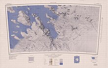
260:The Clark Mountains are north of the head of the
609:
8:
18:
577:United States Antarctic Research Program
16:Mountains in Marie Byrd Land, Antarctica
740:, USGS: United States Geological Survey
729:United States Board on Geographic Names
684:
672:
660:
645:
633:
621:
597:
587:
40:
489:Advisory Committee on Antarctic Names
7:
256:Clark Mountains in northeast of map
762:from websites or documents of the
727:from websites or documents of the
14:
704:Geographic Names of the Antarctic
758: This article incorporates
753:
723: This article incorporates
718:
39:
32:
764:United States Geological Survey
485:United States Geological Survey
278:United States Antarctic Service
701:Alberts, Fred G., ed. (1995),
1:
242:GPX (secondary coordinates)
796:
537:in the Arctic (1913-17).
237:GPX (primary coordinates)
212:Map all coordinates using
26:
286:Worcester, Massachusetts
220:Download coordinates as:
535:Crocker Land Expedition
760:public domain material
725:public domain material
257:
280:(USAS) and named for
255:
232:GPX (all coordinates)
533:and a member of the
411:Mount Van Valkenburg
559: /
513: /
467: /
429: /
391: /
353: /
315: /
264:, northeast of the
199:Allegheny Mountains
160: /
97: /
563:77.283°S 141.733°W
517:77.317°S 141.800°W
471:77.300°S 141.783°W
433:77.317°S 142.100°W
395:77.267°S 142.083°W
357:77.233°S 142.183°W
319:77.267°S 142.283°W
272:Discovery and name
258:
165:77.267°S 142.000°W
102:77.267°S 142.000°W
610:Boyd Glacier USGS
568:-77.283; -141.733
522:-77.317; -141.800
476:-77.300; -141.783
438:-77.317; -142.100
400:-77.267; -142.083
362:-77.233; -142.183
324:-77.267; -142.283
170:-77.267; -142.000
139:
138:
107:-77.267; -142.000
79:Range coordinates
787:
757:
756:
747:
746:
745:
722:
721:
717:
716:
715:
709:
688:
682:
676:
670:
664:
658:
649:
643:
637:
631:
625:
619:
613:
607:
601:
595:
574:
573:
571:
570:
569:
564:
560:
557:
556:
555:
552:
531:Clark University
528:
527:
525:
524:
523:
518:
514:
511:
510:
509:
506:
482:
481:
479:
478:
477:
472:
468:
465:
464:
463:
460:
444:
443:
441:
440:
439:
434:
430:
427:
426:
425:
422:
406:
405:
403:
402:
401:
396:
392:
389:
388:
387:
384:
368:
367:
365:
364:
363:
358:
354:
351:
350:
349:
346:
330:
329:
327:
326:
325:
320:
316:
313:
312:
311:
308:
282:Clark University
266:Mackay Mountains
184:
183:
181:
180:
179:
177:
172:
171:
166:
161:
158:
157:
156:
153:
129:
121:
120:
118:
117:
116:
114:
109:
108:
103:
98:
95:
94:
93:
90:
43:
42:
36:
19:
795:
794:
790:
789:
788:
786:
785:
784:
770:
769:
754:
750:
743:
741:
734:
719:
713:
711:
707:
700:
696:
691:
683:
679:
671:
667:
659:
652:
644:
640:
632:
628:
620:
616:
608:
604:
596:
589:
585:
567:
565:
561:
558:
553:
550:
548:
546:
545:
543:
521:
519:
515:
512:
507:
504:
502:
500:
499:
497:
475:
473:
469:
466:
461:
458:
456:
454:
453:
451:
437:
435:
431:
428:
423:
420:
418:
416:
415:
413:
399:
397:
393:
390:
385:
382:
380:
378:
377:
375:
361:
359:
355:
352:
347:
344:
342:
340:
339:
337:
323:
321:
317:
314:
309:
306:
304:
302:
301:
299:
294:
274:
250:
249:
248:
247:
246:
207:
191:Marie Byrd Land
176:Clark Mountains
175:
173:
169:
167:
163:
162:
159:
154:
151:
149:
147:
146:
143:Clark Mountains
127:
113:Clark Mountains
112:
110:
106:
104:
100:
99:
96:
91:
88:
86:
84:
83:
72:Marie Byrd Land
50:
49:
48:
47:
46:
45:
44:
22:Clark Mountains
17:
12:
11:
5:
793:
791:
783:
782:
772:
771:
768:
767:
749:
748:
732:
697:
695:
692:
690:
689:
687:, p. 215.
677:
675:, p. 455.
665:
650:
648:, p. 106.
638:
636:, p. 376.
626:
614:
602:
600:, p. 138.
586:
584:
581:
542:
541:Kelly Nunataks
539:
496:
493:
450:
449:Mount Maglione
447:
412:
409:
374:
371:
336:
333:
298:
295:
293:
290:
273:
270:
245:
244:
239:
234:
229:
223:
217:
210:
209:
208:
206:
203:
137:
136:
131:
123:
122:
81:
75:
74:
69:
65:
64:
61:
57:
56:
52:
51:
38:
37:
31:
30:
29:
28:
27:
24:
23:
15:
13:
10:
9:
6:
4:
3:
2:
792:
781:
778:
777:
775:
765:
761:
752:
751:
739:
738:
733:
730:
726:
706:
705:
699:
698:
693:
686:
681:
678:
674:
669:
666:
662:
657:
655:
651:
647:
642:
639:
635:
630:
627:
624:, p. 33.
623:
618:
615:
611:
606:
603:
599:
594:
592:
588:
582:
580:
578:
572:
540:
538:
536:
532:
526:
494:
492:
490:
486:
480:
448:
446:
442:
410:
408:
404:
373:Mount Burnham
372:
370:
366:
334:
332:
328:
296:
291:
289:
287:
283:
279:
271:
269:
267:
263:
254:
243:
240:
238:
235:
233:
230:
228:
225:
224:
222:
221:
216:
215:OpenStreetMap
213:
204:
202:
200:
196:
192:
188:
182:
144:
135:
132:
130:
124:
119:
82:
80:
76:
73:
70:
66:
62:
58:
53:
35:
25:
20:
742:, retrieved
737:Boyd Glacier
736:
712:, retrieved
703:
685:Alberts 1995
680:
673:Alberts 1995
668:
661:Alberts 1995
646:Alberts 1995
641:
634:Alberts 1995
629:
622:Alberts 1995
617:
605:
598:Alberts 1995
544:
498:
495:Mount Ekblaw
452:
414:
376:
338:
300:
297:Mount Atwood
275:
262:Boyd Glacier
259:
219:
218:
211:
142:
140:
128:Parent range
780:Ford Ranges
566: /
520: /
474: /
436: /
398: /
360: /
335:Mount Jones
322: /
187:Ford Ranges
168: /
134:Ford Ranges
105: /
744:2024-03-25
714:2023-12-03
583:References
195:Antarctica
174: (
111: (
63:Antarctica
60:Continent
55:Geography
774:Category
554:141°44′W
508:141°48′W
462:141°47′W
424:142°06′W
386:142°05′W
348:142°11′W
310:142°17′W
292:Features
205:Location
694:Sources
551:77°17′S
505:77°19′S
459:77°18′S
421:77°19′S
383:77°16′S
345:77°14′S
307:77°16′S
155:142°0′W
152:77°16′S
92:142°0′W
89:77°16′S
708:(PDF)
141:The
68:Area
284:in
227:KML
776::
653:^
590:^
288:.
201:.
193:,
189:,
766:.
731:.
663:.
612:.
178:)
145:(
115:)
Text is available under the Creative Commons Attribution-ShareAlike License. Additional terms may apply.