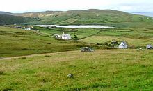
Clashmore, Assynt
Source 📝
19:
150:
191:
210:
111:
83:
215:
184:
177:
30:
157:
46:
18:
91:
87:
161:
67:
204:
149:
42:
126:
113:
54:
50:
38:
17:
53:. It is situated on the Rubha Stoer, 10 km north west of
165:
84:"Placenames collected by Iain Mac an Tailleir"
185:
8:
192:
178:
66:The geographic coordinates are from the
74:
7:
146:
144:
164:. You can help Knowledge (XXG) by
57:, overlooking the Loch na Claise.
14:
148:
211:Populated places in Sutherland
1:
82:Iain Mac an Tàilleir (2003).
37:) is a scattered township in
232:
143:
216:Highland geography stubs
160:location article is a
34:
23:
21:
127:58.22417°N 5.34833°W
123: /
94:on 25 December 2010
88:Scottish Parliament
132:58.22417; -5.34833
24:
173:
172:
223:
194:
187:
180:
152:
145:
138:
137:
135:
134:
133:
128:
124:
121:
120:
119:
116:
104:
103:
101:
99:
90:. Archived from
79:
49:council area of
231:
230:
226:
225:
224:
222:
221:
220:
201:
200:
199:
198:
141:
131:
129:
125:
122:
117:
114:
112:
110:
109:
107:
97:
95:
81:
80:
76:
68:Ordnance Survey
63:
31:Scottish Gaelic
12:
11:
5:
229:
227:
219:
218:
213:
203:
202:
197:
196:
189:
182:
174:
171:
170:
153:
106:
105:
73:
72:
71:
62:
59:
13:
10:
9:
6:
4:
3:
2:
228:
217:
214:
212:
209:
208:
206:
195:
190:
188:
183:
181:
176:
175:
169:
167:
163:
159:
154:
151:
147:
142:
139:
136:
93:
89:
85:
78:
75:
69:
65:
64:
60:
58:
56:
52:
48:
44:
40:
36:
32:
28:
20:
16:
166:expanding it
155:
140:
108:
96:. Retrieved
92:the original
77:
35:An Clais Mór
26:
25:
15:
130: /
205:Categories
115:58°13′27″N
98:29 January
61:References
43:Sutherland
118:5°20′54″W
55:Lochinver
45:, in the
27:Clashmore
22:Clashmore
158:Highland
51:Scotland
47:Highland
39:Assynt
156:This
41:, in
162:stub
100:2011
207::
86:.
33::
193:e
186:t
179:v
168:.
102:.
70:.
29:(
Text is available under the Creative Commons Attribution-ShareAlike License. Additional terms may apply.
↑