709:
42:
54:
390:
The township is governed by a three-member board of trustees, who are elected in
November of odd-numbered years to a four-year term beginning on the following January 1. Two are elected in the year after the presidential election and one is elected in the year before it. There is also an elected
403:
encompasses a large part of the township, with small portions in the southeast served by the
Jackson Center Local School District and the Indian Lake Local School District. The extreme northeastern section of the township is served by the Waynesfield-Goshen Local School District.
391:
township fiscal officer, who serves a four-year term beginning on April 1 of the year after the election, which is held in
November of the year before the presidential election. Vacancies in the fiscal officership or on the board of trustees are filled by the remaining trustees.
567:
67:
642:
1010:
1000:
817:
832:
508:
812:
802:
792:
308:
225:
787:
782:
379:
284:
837:
827:
822:
807:
797:
296:
278:
1005:
357:
635:
371:
290:
235:
41:
200:
53:
439:
400:
628:
486:
562:
370:
The township was also involved in one of the last county border changes in Ohio. This change occurred in 1888 when part of
620:
541:
465:
534:
512:
1015:
777:
314:
263:
121:
99:
847:
302:
652:
255:
126:
977:
412:
210:
509:"Geographic Identifiers: 2010 Demographic Profile Data (G001): Clay township, Auglaize County, Ohio"
348:
According to the U.S. Census Bureau, Clay
Township has an area of 30.3 square miles (78.5 km).
970:
875:
855:
749:
322:
733:
375:
364:
860:
754:
599:
335:
947:
744:
698:
674:
408:
865:
693:
571:
936:
926:
905:
885:
764:
728:
720:
341:
251:
32:
994:
931:
921:
895:
738:
942:
915:
910:
900:
890:
685:
667:
575:
329:
274:
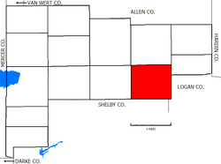
Located in the eastern part of the county, it borders the following townships:
109:
82:
69:
191:
411:(45895) post office, except for a small section in the south served by the
961:‡This populated place also has portions in an adjacent county or counties
595:
591:
587:
344:, along the southwestern border with Stokes Township, Logan County
217:
196:
615:
321:
No municipalities are located in Clay
Township, although several
708:
259:
114:
624:
578:
Magee
Brother Publishing, 1917. Accessed 5 July 2007. Page 119.
487:"Clay township, Auglaize County, Ohio - Census Bureau Profile"
707:
435:
511:. U.S. Census Bureau, American Factfinder. Archived from
461:
363:
The township was formed in 1836, while still a part of
956:
874:
846:
763:
719:
684:
234:
224:
207:
190:
182:
174:
169:
161:
153:
145:
137:
132:
120:
108:
98:
23:
338:, along the northern border with Union Township
636:
8:
58:Location of Clay Township in Auglaize County
378:was exchanged to Clay Township for part of
643:
629:
621:
20:
712:Map of Ohio highlighting Auglaize County
564:Auglaize County, Ohio Atlas and History
424:
223:
189:
168:
160:
131:
97:
62:
50:
38:
407:Most of the township is served by the
380:Goshen Township, Auglaize County, Ohio
430:
428:
233:
206:
181:
173:
152:
144:
136:
119:
107:
7:
1011:Populated places established in 1836
25:Clay Township, Auglaize County, Ohio
149:30.3 sq mi (78.5 km)
141:30.3 sq mi (78.5 km)
1001:Townships in Auglaize County, Ohio
651:Municipalities and communities of
266:found 790 people in the township.
14:
157:0.0 sq mi (0.0 km)
303:Dinsmore Township, Shelby County
52:
40:
440:United States Geological Survey
401:Wapakoneta City School District
297:Jackson Township, Shelby County
18:Township in Ohio, United States
436:"US Board on Geographic Names"
1:
489:. United States Census Bureau
325:are located in the township:
291:Stokes Township, Logan County
1006:1836 establishments in Ohio
542:United States Census Bureau
466:United States Census Bureau
1032:
323:unincorporated communities
165:1,014 ft (309 m)
966:
705:
665:
63:
51:
39:
30:
358:Clay Townships statewide
46:Old house in Saint Johns
250:is one of the fourteen
713:
535:"Detailed map of Ohio"
711:
654:Auglaize County, Ohio
602:. Accessed 4/30/2009.
462:"U.S. Census website"
415:(45334) post office.
262:, United States. The
209: • Summer (
186:26/sq mi (10/km)
83:40.52917°N 84.05167°W
979:United States portal
515:on February 12, 2020
183: • Density
315:Duchouquet Township
88:40.52917; -84.05167
79: /
714:
570:2011-06-11 at the
442:. October 25, 2007
356:It is one of nine
332:, in the southwest
317:- northwest corner
305:- southwest corner
175: • Total
154: • Water
138: • Total
1016:Townships in Ohio
988:
987:
600:Ohio Revised Code
245:
244:
146: • Land
1023:
980:
973:
710:
677:
670:
660:
655:
645:
638:
631:
622:
603:
585:
579:
560:
554:
553:
551:
549:
539:
531:
525:
524:
522:
520:
505:
499:
498:
496:
494:
483:
477:
476:
474:
472:
458:
452:
451:
449:
447:
432:
352:Name and history
309:Pusheta Township
214:
94:
93:
91:
90:
89:
84:
80:
77:
76:
75:
72:
56:
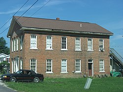
44:
21:
1031:
1030:
1026:
1025:
1024:
1022:
1021:
1020:
991:
990:
989:
984:
978:
971:
962:
952:
877:
870:
842:
759:
715:
703:
680:
675:
668:
661:
658:
653:
649:
612:
607:
606:
586:
582:
572:Wayback Machine
561:
557:
547:
545:
537:
533:
532:
528:
518:
516:
507:
506:
502:
492:
490:
485:
484:
480:
470:
468:
460:
459:
455:
445:
443:
434:
433:
426:
421:
397:
395:Public services
388:
372:Stokes Township
354:
285:Goshen Township
272:
256:Auglaize County
208:
87:
85:
81:
78:
73:
70:
68:
66:
65:
59:
47:
35:
26:
19:
12:
11:
5:
1029:
1027:
1019:
1018:
1013:
1008:
1003:
993:
992:
986:
985:
983:
982:
975:
967:
964:
963:
960:
958:
954:
953:
951:
950:
945:
940:
934:
929:
924:
919:
913:
908:
903:
898:
893:
888:
882:
880:
876:Unincorporated
872:
871:
869:
868:
863:
858:
852:
850:
844:
843:
841:
840:
835:
830:
825:
820:
815:
810:
805:
800:
795:
790:
785:
780:
775:
769:
767:
761:
760:
758:
757:
752:
747:
742:
736:
731:
725:
723:
717:
716:
706:
704:
702:
701:
696:
690:
688:
682:
681:
666:
663:
662:
650:
648:
647:
640:
633:
625:
619:
618:
616:County website
611:
610:External links
608:
605:
604:
580:
555:
526:
500:
478:
453:
423:
422:
420:
417:
413:Jackson Center
396:
393:
387:
384:
353:
350:
346:
345:
339:
333:
319:
318:
312:
306:
300:
294:
288:
282:
279:Union Township
271:
268:
243:
242:
239:
232:
231:
228:
222:
221:
215:
205:
204:
194:
188:
187:
184:
180:
179:
176:
172:
171:
167:
166:
163:
159:
158:
155:
151:
150:
147:
143:
142:
139:
135:
134:
130:
129:
124:
118:
117:
112:
106:
105:
102:
96:
95:
61:
60:
57:
49:
48:
45:
37:
36:
31:
28:
27:
24:
17:
13:
10:
9:
6:
4:
3:
2:
1028:
1017:
1014:
1012:
1009:
1007:
1004:
1002:
999:
998:
996:
981:
976:
974:
969:
968:
965:
959:
955:
949:
946:
944:
941:
938:
935:
933:
930:
928:
925:
923:
920:
917:
914:
912:
909:
907:
904:
902:
899:
897:
894:
892:
889:
887:
884:
883:
881:
879:
873:
867:
864:
862:
859:
857:
856:New Hampshire
854:
853:
851:
849:
845:
839:
836:
834:
831:
829:
826:
824:
821:
819:
816:
814:
811:
809:
806:
804:
801:
799:
796:
794:
791:
789:
786:
784:
781:
779:
776:
774:
771:
770:
768:
766:
762:
756:
753:
751:
750:New Knoxville
748:
746:
743:
740:
737:
735:
732:
730:
727:
726:
724:
722:
718:
700:
697:
695:
692:
691:
689:
687:
683:
679:
678:
671:
664:
659:United States
656:
646:
641:
639:
634:
632:
627:
626:
623:
617:
614:
613:
609:
601:
597:
593:
589:
584:
581:
577:
573:
569:
566:
565:
559:
556:
543:
536:
530:
527:
514:
510:
504:
501:
488:
482:
479:
467:
463:
457:
454:
441:
437:
431:
429:
425:
418:
416:
414:
410:
405:
402:
394:
392:
385:
383:
381:
377:
373:
368:
366:
361:
359:
351:
349:
343:
340:
337:
334:
331:
328:
327:
326:
324:
316:
313:
310:
307:
304:
301:
298:
295:
292:
289:
286:
283:
280:
277:
276:
275:
269:
267:
265:
261:
257:
253:
249:
248:Clay Township
240:
237:
229:
227:
219:
216:
212:
202:
201:Eastern (EST)
198:
195:
193:
185:
177:
164:
156:
148:
140:
128:
125:
123:
116:
113:
111:
104:United States
103:
101:
92:
64:Coordinates:
55:
43:
34:
29:
22:
16:
772:
734:Cridersville
673:
583:
563:
558:
548:February 16,
546:. Retrieved
529:
517:. Retrieved
513:the original
503:
491:. Retrieved
481:
469:. Retrieved
456:
444:. Retrieved
406:
398:
389:
376:Logan County
369:
365:Allen County
362:
355:
347:
320:
273:
247:
246:
15:
972:Ohio portal
878:communities
861:Saint Johns
818:Saint Marys
755:Waynesfield
694:Saint Marys
669:County seat
471:January 31,
446:January 31,
336:Saint Johns
287:- northeast
264:2020 census
86: /
995:Categories
948:Villa Nova
833:Washington
778:Duchouquet
745:New Bremen
699:Wapakoneta
676:Wapakoneta
419:References
409:Wapakoneta
386:Government
238:feature ID
170:Population
71:40°31′45″N
957:Footnotes
866:Uniopolis
765:Townships
270:Geography
252:townships
226:FIPS code
192:Time zone
162:Elevation
937:Santa Fe
927:Lock Two
906:Glynwood
886:Bulkhead
729:Buckland
721:Villages
568:Archived
519:July 10,
342:Santa Fe
230:39-15448
127:Auglaize
74:84°3′6″W
33:Township
932:Moulton
922:Kossuth
896:Fryburg
813:Pusheta
803:Moulton
793:Jackson
739:Minster
598:of the
596:§507.01
592:§505.01
588:§503.24
493:May 21,
299:- south
281:- north
241:1085762
100:Country
943:Slater
916:Holden
911:Gutman
788:Goshen
783:German
686:Cities
594:, and
576:Piqua:
544:. 2000
311:- west
293:- east
122:County
901:Geyer
891:Egypt
838:Wayne
828:Union
823:Salem
808:Noble
798:Logan
538:(PDF)
330:Geyer
220:(EDT)
218:UTC-4
197:UTC-5
110:State
848:CDPs
773:Clay
550:2007
521:2013
495:2023
473:2008
448:2008
399:The
260:Ohio
236:GNIS
133:Area
115:Ohio
374:in
254:of
211:DST
178:790
997::
672::
657:,
590:,
574:,
540:.
464:.
438:.
427:^
382:.
367:.
360:.
258:,
939:‡
918:‡
741:‡
644:e
637:t
630:v
552:.
523:.
497:.
475:.
450:.
213:)
203:)
199:(
Text is available under the Creative Commons Attribution-ShareAlike License. Additional terms may apply.