510:
usually followed about 1670. In later times the pronunciation of the last syllable had reverted to the original form, that of the first and second remaining as it was so that
Cochecho became the name; this is seen to be almost the exact original pronunciation and has been well settled for years. The spelling KECHEACHY was used occasionally a few years after 1700, but it never came into general use. The form QUOCHECHO is an unmitigated barbarism, so is COCHECO, although its unfortunate adoption by the Manufacturing Company of this place has given some credit to that form. The form COCHECHO is best supported by old examples and is at present generally adopted by all who know anything of its origin."
61:
569:
86:
44:
597:
515:
93:
68:
509:
The first record in which we meet the name is in 1642, and in that the name is spelt CUTTCHECHOE, the pronunciation of which is evident. In 1648 it is spelt COCHCHECHOE and so pronounced for many years. In 1650 COCHECHAE is met with for once, and the pronunciation of this manner of spelling was that
530:
bought the
Cocheco Manufacturing Company and set about making changes, one of which was to end the disparity between the river's historic spelling and its brand. But instead of revising its name, it chose to revise the river's name, perhaps hoping to elevate its barbarism by having it recognized by
490:
was founded, and its brick buildings would come to dominate the riverfront. But as historian
Caroline Harwood Garland writes, "By an error of the engrossing clerk in the act of incorporation, the old Indian word, Cochecho, became Cocheco." As historian Alonzo Hall Quint laments: "The chief fault of
576:
To end the confusion, the BGN received a formal proposal in 2015 to correct the
Cochecho River's spelling by reversing its 1911 decision. The petition was supported by the Dover mayor, Dover City Council, the NH Department of Cultural Resources (which includes the NH Division of Historical
455:
word meaning "rapid foaming water," referring to
Cochecho Falls in downtown Dover. Settlers adopted the name for both the river and principal settlement, the village of Cochecho. One of the oldest place names in New Hampshire, and the original name of Dover, Cochecho is at risk of
580:
But the
Domestic Names Committee (DNC) of the BGN disregarded supporters and declined the petition. It also disregarded maps and records (including its own) which prove that until 1911 the river's name was Cochecho. Instead, it based its decision on
553:, and its brand name on the river. With the public confused about which spelling is correct, the form Cocheco spread to uses unrelated to the mill. For example, the defunct Cochecho Railroad is frequently misidentified as the Cocheco Railroad, and the
577:
Resources), and the NH Department of
Resources and Economic Development. Support also came from the Dover Chamber of Commerce, which operates the Cochecho Arts Festival and promotes the Cochecho Waterfront Development.
1906:
535:
to transgress federal ethics and corrupt the name of the
Cochecho River to the Cocheco River. The BGN recorded no justification for the change, suggesting that it was paid off.
783:
1901:
744:
542:
conflict which continues to this day, with signs on Dover city bridges identifying the stream as the
Cochecho River, while maps identify it as the Cocheco River.
60:
808:
1012:
85:
1856:
1676:
1360:
1246:
1261:
1216:
737:
1469:
1365:
947:
550:
1781:
1266:
882:
363:
1861:
1731:
1896:
1504:
1211:
1062:
730:
280:
203:
1726:
1604:
1281:
982:
757:
753:
610:
138:
1666:
1256:
1191:
1082:
1052:
997:
962:
942:
907:
862:
704:
1007:
877:
798:
491:
the present
Company is their barbarous spelling of 'Cocheco' instead of 'Cochecho,' for which no possible excuse exists."
1791:
1756:
1701:
1589:
1559:
1474:
1390:
1370:
1320:
1315:
1271:
1117:
1102:
818:
788:
532:
1841:
1816:
1716:
1599:
1579:
1509:
1499:
1464:
1454:
1380:
1340:
1231:
1226:
1112:
1087:
847:
1771:
1554:
1484:
1181:
1132:
957:
852:
502:
It has been ill-treated in a most serious manner. Every person seems to have felt himself authorized to manage its
1826:
1539:
1489:
1375:
1276:
1196:
872:
842:
813:
436:
404:
189:
152:
148:
1831:
1776:
1686:
1594:
1534:
1137:
1077:
937:
705:"U.S. Board on Geographic Names Domestic Names Committee: Seven Hundred and Eighty-second Meeting; May 5, 2016"
408:
156:
1821:
1766:
1529:
1201:
902:
527:
1851:
1584:
1524:
1494:
1866:
1127:
476:
568:
952:
602:
412:
266:
160:
1251:
1171:
1142:
803:
582:
416:
1656:
1415:
1385:
1221:
1186:
1166:
1157:
1022:
977:
424:
640:
Garland, Caroline Harwood, Old Dover, New Hampshire; Castle Books, Edison, NJ 1987, 2002 p. 383
1671:
1637:
1628:
1514:
1410:
1395:
1032:
1002:
887:
367:
722:
1646:
1614:
1420:
1405:
1291:
1206:
1152:
1027:
987:
897:
546:
400:
388:
254:
43:
1796:
1786:
1549:
1400:
1345:
1042:
1017:
972:
828:
464:
440:
371:
538:
Nevertheless, Dover's original name did not go away. Instead, the dual spellings began a
467:
was granted water privileges at Cochecho Falls, moving there from Dover Point to build a
1806:
1651:
1574:
1479:
1459:
1449:
1425:
1072:
1047:
927:
837:
774:
514:
1890:
1871:
1846:
1836:
1741:
1736:
1706:
1609:
1544:
1355:
1305:
1236:
1107:
1092:
1067:
922:
917:
765:
667:
Hindle, Thom, Dover, Images of America; Arcadia Publishing, Portsmouth, Nh 1994 p. 72
658:
Quint, Alonzo Hall, Persons and Places in Old Dover, Heritage Books, Bowie, MD p. 108
649:
Quint, Alonzo Hall, Persons and Places in Old Dover, Heritage Books, Bowie, MD p. 419
554:
487:
396:
128:
118:
685:
Tischler, Michael A., email from the US Board on Geographic Names, October 25, 2023
1811:
1801:
1711:
1691:
1569:
1519:
1335:
1310:
1241:
1176:
1122:
1037:
992:
967:
912:
857:
793:
549:. All that remains of the mill are its repurposed factory buildings, listed on the
523:
483:
1761:
1751:
1350:
1097:
1057:
892:
867:
503:
420:
249:
1746:
1721:
1696:
1681:
1661:
1564:
1440:
1300:
932:
592:
457:
392:
295:
282:
218:
205:
17:
1330:
694:
Gallager, Ken, email to the US Board on Geographic Names, September 15, 2015
676:
Gallager, Ken, email to the US Board on Geographic Names, September 15, 2015
583:
misinformation which purported that Cochecho is no more correct than Cocheco
506:
in any way he chose; hence all sorts of ways of spelling it have prevailed.
472:
432:
359:
1435:
539:
468:
452:
545:
In 1937, the Cocheco Manufacturing Company folded, a casualty of the
480:
557:, a famous event in New Hampshire history, is occasionally abused.
431:
border to form the Piscataqua. Significant tributaries include the
567:
513:
428:
726:
629:
630:
New Hampshire GRANIT state geographic information system
498:
Quint records the history of the Cochecho River's name:
531:
the government. In 1911, the business manipulated the
1636:
1627:
1434:
1290:
1151:
827:
773:
764:
352:
342:
334:
329:
321:
311:
272:
260:
248:
234:
195:
183:
175:
166:
144:
134:
124:
114:
109:
32:
1907:New Hampshire placenames of Native American origin
738:
8:
403:and runs southeastward, through the town of
1633:
770:
745:
731:
723:
479:, these industries would be supplanted by
419:. Below the center of Dover, the river is
348:Dames Brook, Blackwater Brook, Fresh Creek
1902:Rivers of Strafford County, New Hampshire
1013:North Fork East Branch Pemigewasset River
391:, 38.3 miles (61.6 km) long, in the
622:
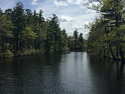
48:The Cochecho at Hanson Pines, Rochester
1247:South Branch Little Dead Diamond River
92:
67:
29:
1262:West Branch Little Dead Diamond River
1217:Middle Branch Little Magalloway River
27:River in New Hampshire, United States
7:
948:Little Massabesic Brook-Sucker Brook
551:National Register of Historic Places
460:because of bureaucratic corruption.
1782:North Branch Upper Ammonoosuc River
1267:West Branch Little Magalloway River
1862:West Branch Upper Ammonoosuc River
25:
494:In an 1851 essay written for the
1505:East Fork East Branch Saco River
1212:Middle Branch Dead Diamond River
707:. U.S. Board on Geographic Names
595:
572:Cochecho Riverwalk sign in Dover
564:Petition to correct the spelling
91:
84:
66:
59:
42:
983:Middle Branch Piscataquog River
611:List of rivers of New Hampshire
1257:West Branch Dead Diamond River
1192:East Branch Dead Diamond River
1083:South Branch Piscataquog River
943:Little River (Merrimack River)
908:East Branch Pemigewasset River
274: • coordinates
197: • coordinates
1:
1008:North Branch Contoocook River
488:Cocheco Manufacturing Company
167:Physical characteristics
100:Show map of the United States
1590:Swift River (Bearcamp River)
1371:Little River (Lamprey River)
1272:West Branch Magalloway River
533:US Board on Geographic Names
313: • elevation
236: • elevation
1817:South Branch Ashuelot River
1500:East Branch Whiteface River
1465:Cold River (Bearcamp River)
1088:South Branch Souhegan River
325:38.3 mi (61.6 km)
262: • location
185: • location
1923:
1772:North Branch Millers River
1133:West Branch Souhegan River
1827:South Branch Israel River
1277:West Branch Peabody River
1197:Little Dead Diamond River
244:
171:
75:Show map of New Hampshire
53:
41:
1857:West Branch Mohawk River
1832:South Branch Sugar River
1777:North Branch Sugar River
1677:East Branch Mohawk River
1595:Swift River (Saco River)
1361:Little River (Brentwood)
1138:West Branch Warner River
1078:South Branch Baker River
938:Little River (Big River)
387:) is a tributary of the
354: • right
240:880 ft (270 m)
1897:Rivers of New Hampshire
1822:South Branch Gale River
1767:North Branch Gale River
1530:Middle Branch Mad River
1202:Little Magalloway River
903:East Branch Baker River
754:Rivers of New Hampshire
528:Lawrence, Massachusetts
399:. It rises in northern
344: • left
1852:Upper Ammonoosuc River
1585:South Branch Mad River
1495:East Branch Saco River
573:
519:
512:
1867:Wild Ammonoosuc River
1366:Little River (Exeter)
1128:West Branch Mad River
571:
518:Plan of Dover in 1892
517:
500:
477:Industrial Revolution
296:43.17556°N 70.82472°W
219:43.45944°N 71.11583°W
953:Little Suncook River
603:New Hampshire portal
415:, where it provides
370:, Axe Handle Brook,
317:0 ft (0 m)
1252:Swift Diamond River
1172:Chickwolnepy Stream
1143:Winnipesaukee River
804:Hampton Falls River
447:History of the name
417:hydroelectric power
330:Basin features
301:43.17556; -70.82472
292: /
224:43.45944; -71.11583
215: /
1732:Little Sugar River
1657:Blow-me-down Brook
1416:Salmon Falls River
1386:North Branch River
1222:Mollidgewock Brook
1187:Dead Diamond River
1167:Androscoggin River
1158:Androscoggin River
1023:Pemigewasset River
978:Merrymeeting River
574:
520:
425:Salmon Falls River
407:and the cities of
145:Towns & cities
1884:
1883:
1880:
1879:
1672:Connecticut River
1638:Connecticut River
1629:Long Island Sound
1623:
1622:
1515:Little Cold River
1411:Rattlesnake River
1396:Pawtuckaway River
1033:Piscataquog River
1003:Nissitissit River
888:Cockermouth River
555:Cochecho Massacre
377:
376:
368:Rattlesnake River
16:(Redirected from
1914:
1647:Ammonoosuc River
1634:
1615:Wonalancet River
1421:Squamscott River
1406:Piscataqua River
1292:Piscataqua River
1207:Magalloway River
1153:Merrymeeting Bay
1028:Pennichuck Brook
988:Moosilauke Brook
898:Contoocook River
883:Blackwater River
784:Blackwater River
775:Atlantic coastal
771:
747:
740:
733:
724:
717:
716:
714:
712:
701:
695:
692:
686:
683:
677:
674:
668:
665:
659:
656:
650:
647:
641:
638:
632:
627:
605:
600:
599:
598:
547:Great Depression
401:Strafford County
389:Piscataqua River
355:
345:
307:
306:
304:
303:
302:
297:
293:
290:
289:
288:
285:
255:Piscataqua River
237:
230:
229:
227:
226:
225:
220:
216:
213:
212:
211:
208:
198:
186:
101:
95:
94:
88:
76:
70:
69:
63:
46:
30:
21:
1922:
1921:
1917:
1916:
1915:
1913:
1912:
1911:
1887:
1886:
1885:
1876:
1797:Partridge Brook
1787:Oliverian Brook
1619:
1605:Whiteface River
1550:Pequawket Brook
1438:
1430:
1401:Piscassic River
1346:Isinglass River
1286:
1155:
1147:
1043:Purgatory Brook
1018:Nubanusit Brook
973:Merrimack River
829:Merrimack River
823:
760:
758:drainage system
751:
721:
720:
710:
708:
703:
702:
698:
693:
689:
684:
680:
675:
671:
666:
662:
657:
653:
648:
644:
639:
635:
628:
624:
619:
601:
596:
594:
591:
566:
560:
496:Dover Enquirer,
486:. In 1827, the
465:Richard Waldron
451:Cochecho is an
449:
441:Isinglass River
372:Isinglass River
353:
343:
314:
300:
298:
294:
291:
286:
283:
281:
279:
278:
275:
263:
235:
223:
221:
217:
214:
209:
206:
204:
202:
201:
196:
184:
105:
104:
103:
102:
99:
98:
97:
96:
79:
78:
77:
74:
73:
72:
71:
49:
37:
34:
28:
23:
22:
15:
12:
11:
5:
1920:
1918:
1910:
1909:
1904:
1899:
1889:
1888:
1882:
1881:
1878:
1877:
1875:
1874:
1869:
1864:
1859:
1854:
1849:
1844:
1839:
1834:
1829:
1824:
1819:
1814:
1809:
1807:Phillips Brook
1804:
1799:
1794:
1789:
1784:
1779:
1774:
1769:
1764:
1759:
1754:
1749:
1744:
1739:
1734:
1729:
1724:
1719:
1714:
1709:
1704:
1699:
1694:
1689:
1684:
1679:
1674:
1669:
1664:
1659:
1654:
1652:Ashuelot River
1649:
1643:
1641:
1631:
1625:
1624:
1621:
1620:
1618:
1617:
1612:
1607:
1602:
1597:
1592:
1587:
1582:
1577:
1575:Shepards River
1572:
1567:
1562:
1557:
1552:
1547:
1542:
1537:
1532:
1527:
1522:
1517:
1512:
1507:
1502:
1497:
1492:
1487:
1482:
1480:Dan Hole River
1477:
1472:
1467:
1462:
1460:Chocorua River
1457:
1452:
1450:Bearcamp River
1446:
1444:
1432:
1431:
1429:
1428:
1426:Winnicut River
1423:
1418:
1413:
1408:
1403:
1398:
1393:
1388:
1383:
1378:
1373:
1368:
1363:
1358:
1353:
1348:
1343:
1338:
1333:
1328:
1326:Cochecho River
1323:
1318:
1313:
1308:
1303:
1297:
1295:
1288:
1287:
1285:
1284:
1279:
1274:
1269:
1264:
1259:
1254:
1249:
1244:
1239:
1234:
1229:
1224:
1219:
1214:
1209:
1204:
1199:
1194:
1189:
1184:
1179:
1174:
1169:
1163:
1161:
1149:
1148:
1146:
1145:
1140:
1135:
1130:
1125:
1120:
1115:
1110:
1105:
1100:
1095:
1090:
1085:
1080:
1075:
1073:Souhegan River
1070:
1065:
1060:
1055:
1050:
1048:Red Hill River
1045:
1040:
1035:
1030:
1025:
1020:
1015:
1010:
1005:
1000:
998:Newfound River
995:
990:
985:
980:
975:
970:
965:
960:
955:
950:
945:
940:
935:
930:
928:Gunstock River
925:
920:
915:
910:
905:
900:
895:
890:
885:
880:
875:
870:
865:
860:
855:
850:
845:
840:
838:Baboosic Brook
834:
832:
825:
824:
822:
821:
816:
811:
806:
801:
796:
791:
786:
780:
778:
768:
762:
761:
752:
750:
749:
742:
735:
727:
719:
718:
696:
687:
678:
669:
660:
651:
642:
633:
621:
620:
618:
615:
614:
613:
607:
606:
590:
587:
565:
562:
448:
445:
423:and joins the
381:Cochecho River
375:
374:
356:
350:
349:
346:
340:
339:
336:
332:
331:
327:
326:
323:
319:
318:
315:
312:
309:
308:
276:
273:
270:
269:
264:
261:
258:
257:
252:
246:
245:
242:
241:
238:
232:
231:
199:
193:
192:
187:
181:
180:
177:
173:
172:
169:
168:
164:
163:
146:
142:
141:
136:
132:
131:
126:
122:
121:
116:
112:
111:
107:
106:
90:
89:
83:
82:
81:
80:
65:
64:
58:
57:
56:
55:
54:
51:
50:
47:
39:
38:
35:
33:Cochecho River
26:
24:
14:
13:
10:
9:
6:
4:
3:
2:
1919:
1908:
1905:
1903:
1900:
1898:
1895:
1894:
1892:
1873:
1872:Zealand River
1870:
1868:
1865:
1863:
1860:
1858:
1855:
1853:
1850:
1848:
1847:Tarbell Brook
1845:
1843:
1840:
1838:
1837:Stocker Brook
1835:
1833:
1830:
1828:
1825:
1823:
1820:
1818:
1815:
1813:
1810:
1808:
1805:
1803:
1800:
1798:
1795:
1793:
1790:
1788:
1785:
1783:
1780:
1778:
1775:
1773:
1770:
1768:
1765:
1763:
1760:
1758:
1755:
1753:
1750:
1748:
1745:
1743:
1742:Millers River
1740:
1738:
1737:Mascoma River
1735:
1733:
1730:
1728:
1725:
1723:
1720:
1718:
1715:
1713:
1710:
1708:
1707:Indian Stream
1705:
1703:
1700:
1698:
1695:
1693:
1690:
1688:
1685:
1683:
1680:
1678:
1675:
1673:
1670:
1668:
1665:
1663:
1660:
1658:
1655:
1653:
1650:
1648:
1645:
1644:
1642:
1639:
1635:
1632:
1630:
1626:
1616:
1613:
1611:
1610:Wildcat Brook
1608:
1606:
1603:
1601:
1598:
1596:
1593:
1591:
1588:
1586:
1583:
1581:
1578:
1576:
1573:
1571:
1568:
1566:
1563:
1561:
1558:
1556:
1553:
1551:
1548:
1546:
1545:Ossipee River
1543:
1541:
1538:
1536:
1533:
1531:
1528:
1526:
1523:
1521:
1518:
1516:
1513:
1511:
1508:
1506:
1503:
1501:
1498:
1496:
1493:
1491:
1488:
1486:
1483:
1481:
1478:
1476:
1473:
1471:
1468:
1466:
1463:
1461:
1458:
1456:
1453:
1451:
1448:
1447:
1445:
1442:
1437:
1433:
1427:
1424:
1422:
1419:
1417:
1414:
1412:
1409:
1407:
1404:
1402:
1399:
1397:
1394:
1392:
1389:
1387:
1384:
1382:
1379:
1377:
1374:
1372:
1369:
1367:
1364:
1362:
1359:
1357:
1356:Lamprey River
1354:
1352:
1349:
1347:
1344:
1342:
1339:
1337:
1334:
1332:
1329:
1327:
1324:
1322:
1319:
1317:
1314:
1312:
1309:
1307:
1306:Bellamy River
1304:
1302:
1299:
1298:
1296:
1293:
1289:
1283:
1280:
1278:
1275:
1273:
1270:
1268:
1265:
1263:
1260:
1258:
1255:
1253:
1250:
1248:
1245:
1243:
1240:
1238:
1237:Peabody River
1235:
1233:
1230:
1228:
1225:
1223:
1220:
1218:
1215:
1213:
1210:
1208:
1205:
1203:
1200:
1198:
1195:
1193:
1190:
1188:
1185:
1183:
1180:
1178:
1175:
1173:
1170:
1168:
1165:
1164:
1162:
1159:
1154:
1150:
1144:
1141:
1139:
1136:
1134:
1131:
1129:
1126:
1124:
1121:
1119:
1116:
1114:
1111:
1109:
1108:Suncook River
1106:
1104:
1101:
1099:
1096:
1094:
1093:Spicket River
1091:
1089:
1086:
1084:
1081:
1079:
1076:
1074:
1071:
1069:
1068:Soucook River
1066:
1064:
1061:
1059:
1056:
1054:
1051:
1049:
1046:
1044:
1041:
1039:
1036:
1034:
1031:
1029:
1026:
1024:
1021:
1019:
1016:
1014:
1011:
1009:
1006:
1004:
1001:
999:
996:
994:
991:
989:
986:
984:
981:
979:
976:
974:
971:
969:
966:
964:
961:
959:
956:
954:
951:
949:
946:
944:
941:
939:
936:
934:
931:
929:
926:
924:
923:Gridley River
921:
919:
918:Frazier Brook
916:
914:
911:
909:
906:
904:
901:
899:
896:
894:
891:
889:
886:
884:
881:
879:
876:
874:
871:
869:
866:
864:
861:
859:
856:
854:
851:
849:
846:
844:
841:
839:
836:
835:
833:
830:
826:
820:
817:
815:
812:
810:
807:
805:
802:
800:
799:Hampton River
797:
795:
792:
790:
787:
785:
782:
781:
779:
776:
772:
769:
767:
766:Gulf of Maine
763:
759:
755:
748:
743:
741:
736:
734:
729:
728:
725:
706:
700:
697:
691:
688:
682:
679:
673:
670:
664:
661:
655:
652:
646:
643:
637:
634:
631:
626:
623:
616:
612:
609:
608:
604:
593:
588:
586:
584:
578:
570:
563:
561:
558:
556:
552:
548:
543:
541:
536:
534:
529:
525:
524:Pacific Mills
516:
511:
507:
505:
499:
497:
492:
489:
485:
484:textile mills
482:
478:
475:. During the
474:
470:
466:
461:
459:
454:
446:
444:
442:
438:
434:
430:
426:
422:
418:
414:
410:
406:
402:
398:
397:New Hampshire
394:
390:
386:
385:Cocheco River
383:(incorrectly
382:
373:
369:
365:
361:
358:Hayes Brook,
357:
351:
347:
341:
337:
333:
328:
324:
320:
316:
310:
305:
277:
271:
268:
265:
259:
256:
253:
251:
247:
243:
239:
233:
228:
200:
194:
191:
188:
182:
178:
174:
170:
165:
162:
158:
154:
150:
147:
143:
140:
137:
133:
130:
129:New Hampshire
127:
123:
120:
119:United States
117:
113:
108:
87:
62:
52:
45:
40:
36:Cocheco River
31:
19:
18:Cocheco River
1812:Simms Stream
1802:Perry Stream
1757:Mohawk River
1727:Little River
1712:Israel River
1702:Indian River
1692:Halls Stream
1570:Sawyer River
1560:Rocky Branch
1520:Lovell River
1475:Cutler River
1391:Oyster River
1336:Exeter River
1325:
1321:Bunker Creek
1316:Branch River
1311:Berrys River
1242:Rattle River
1177:Clear Stream
1123:Warner River
1118:Turkey River
1053:Salmon Brook
1038:Powwow River
993:Nashua River
968:Melvin River
913:Fowler River
863:Beaver Brook
858:Beards Brook
819:Taylor River
809:Little River
794:Drakes River
789:Browns River
709:. Retrieved
699:
690:
681:
672:
663:
654:
645:
636:
625:
579:
575:
559:
544:
537:
521:
508:
501:
495:
493:
462:
450:
384:
380:
378:
1842:Sugar River
1792:Otter Brook
1762:Nash Stream
1752:Mirey Brook
1717:Johns River
1687:Great Brook
1600:West Branch
1580:South River
1510:Ellis River
1455:Beech River
1381:North River
1351:Jones Brook
1341:Fresh River
1232:Moose River
1227:Moose Brook
1113:Tioga River
1103:Stony Brook
1098:Squam River
1063:Smith River
1058:Shedd Brook
893:Cohas Brook
878:Black Brook
868:Beebe River
848:Baker River
777:tributaries
504:orthography
335:Tributaries
299: /
222: /
1891:Categories
1747:Mink Brook
1722:Knox River
1697:Ham Branch
1682:Gale River
1667:Cold River
1662:The Branch
1565:Saco River
1555:Pine River
1535:Mill Brook
1485:Deer River
1470:Cold River
1443:watershed)
1441:Saco River
1301:Bean River
1282:Wild River
1182:Dead River
1160:watershed)
958:Lost River
933:Lane River
853:Bear Brook
843:Back River
711:October 2,
617:References
458:extinction
439:, and the
405:Farmington
393:U.S. state
287:70°49′29″W
284:43°10′32″N
207:43°27′34″N
190:New Durham
153:Farmington
149:New Durham
1640:watershed
1540:New River
1525:Mad River
1490:Dry River
1376:Mad River
1331:Ela River
1294:watershed
963:Mad River
873:Big River
831:watershed
814:Old River
522:In 1909,
473:gristmill
463:In 1642,
437:Mad River
433:Ela River
409:Rochester
364:Mad River
360:Ela River
210:71°6′57″W
157:Rochester
139:Strafford
1436:Saco Bay
589:See also
540:semiotic
110:Location
469:sawmill
453:Abenaki
427:at the
115:Country
481:cotton
435:, the
338:
322:Length
179:
176:Source
135:County
429:Maine
421:tidal
413:Dover
267:Dover
250:Mouth
161:Dover
125:State
713:2017
585:.
471:and
411:and
379:The
756:by
526:of
395:of
1893::
443:.
366:,
362:,
159:,
155:,
151:,
1439:(
1156:(
746:e
739:t
732:v
715:.
20:)
Text is available under the Creative Commons Attribution-ShareAlike License. Additional terms may apply.