572:
60:
703:
80:
764:
47:
87:
364:
A bathymetric survey of the lake was carried out between
December 1996 and February 1997, using an Echo Sounder with GPS navigation. The results showed that the central basin of the lake reaches a depth of 460m (1,509 ft). This deep central basin is separated by a shallow sill from a series of
306:
on the
Argentina side. The border is a peninsula that juts out into the lake on the north side. The border to the north of the lake follows the ridgeline of the last major expression of the eastern Andes. The Argentine portion of the lake has a surface of 150 km (58 sq mi), while the
459:
116:
415:
Extended
Extracts of the Fourth International Symposium on Andean Geodynamics, Gottingen, Germany 04-06/10/1999 by Institut de Recherche pour le Développement PARIS 1999. Pages 539-541.
854:
413:
Ruth E. Murdie, David T. Pugh, Peter Styles and Miguel Muňoz (1999) - Heatflow, Temperature and
Bathymetry of Lago General Carrera and Lago Cochrane, Southern Chile. (Published:
824:
748:
452:
849:
805:
445:
859:
299:
79:
334:
has a small stream named Oro River, originating on its north flank that flows generally northeastward into Lake
Pueyrredón. The vast semi-arid
139:
431:
839:
844:
120:
741:
834:
571:
798:
601:
303:
710:
358:
124:
734:
677:
657:
430:
Image
Science and Analysis Laboratory, NASA-Johnson Space Center. 18 Mar. 2005. "Earth from Space - Image Information."
414:
383:
791:
112:
343:
829:
606:
667:
178:
59:
31:
171:
108:
662:
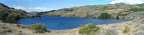
642:
596:
702:
647:
526:
491:
323:
672:
521:
319:
310:
A narrow land bridge separates the southern end of Lake
Pueyrredón from the smaller, shallower
611:
331:
269:
775:
718:
365:
small deep basins of just over 200 metres depth, which comprise the western end of the lake.
632:
682:
637:
546:
496:
354:
771:
472:
516:
506:
486:
347:
327:
315:
195:
185:
818:
591:
551:
511:
763:
536:
531:
501:
311:
652:
616:
556:
468:
339:
541:
437:
154:
141:
17:
714:
561:
335:
291:
201:
46:
390:
389:. Ministerio de Obras Públicas. Dirección General de Aguas. Archived from
346:
cut canyons across the plateau. The former is the main tributary of the
283:
172:
295:
287:
205:
441:
30:"Cochrane Lake" redirects here. For the hamlet in Canada, see
307:
portion in Chile covers 175 km (68 sq mi).
330:
on its western edge. The 12,156 foot (3,706 meter) high
779:
722:
322:
basin to the northeast. Cochrane Lake drains into the
286:
fed lake located on the eastern edge of the southern
625:
579:
479:
263:
255:
247:
239:
231:
223:
215:
211:
194:
184:
170:
131:
104:
39:
384:"Hoyas hidrográficas de Chile. Duodécima Región"
132:
117:Aysén del General Carlos Ibáñez del Campo Region
86:
855:Santa Cruz Province, Argentina geography stubs
799:
742:
453:
8:
806:
792:
749:
735:
460:
446:
438:
36:
361:are located in the vicinity of the lake.
825:Lakes of Santa Cruz Province, Argentina
432:NM23-722-000B Lakes Pueyrredon and Ghio
374:
27:Lake in Santa Cruz Province, Argentina
7:
850:International lakes of South America
760:
758:
699:
697:
243:33.09 km (7.94 cu mi)
338:Plateau lies east of the lake. The
190:2,570 km (990 sq mi)
778:. You can help Knowledge (XXG) by
721:. You can help Knowledge (XXG) by
25:
219:325 km (125 sq mi)
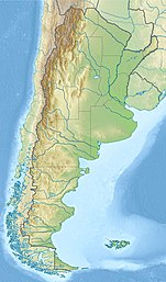
68:Cochrane Lake in the Aysén Region
762:
701:
570:
290:, straddling the border between
85:
78:
58:
45:
254:
246:
238:
230:
222:
214:
709:This article about a place in
359:Lago Cochrane National Reserve
1:
678:Southern Patagonian Ice Field
658:Northern Patagonian Ice Field
103:
860:Aysén Region geography stubs
840:Austral or Magallanes Basin
876:
757:
696:
270:not a well-defined measure
235:460 m (1,510 ft)
227:101.8 m (334 ft)
29:
568:
304:Juan Martín de Pueyrredón
267:
251:239 km (149 mi)
73:
53:
44:
302:on the Chilean side and
280:Pueyrredón/Cochrane Lake
259:153 m (502 ft)
93:Pueyrredón/Cochrane Lake
40:Pueyrredón/Cochrane Lake
382:Niemeyer, Hans (1980).
845:Argentina–Chile border
774:location article is a
32:Cochrane Lake, Alberta
835:Lakes of Aysén Region
113:Capitán Prat Province
298:. It is named after
121:Río Chico Department
711:Santa Cruz Province
326:through the short
318:is bordered by the
151: /
125:Santa Cruz Province
787:
786:
730:
729:
691:
690:
332:Monte San Lorenzo
276:
275:
256:Surface elevation
155:47.267°S 72.050°W
16:(Redirected from
867:
808:
801:
794:
766:
759:
751:
744:
737:
705:
698:
574:
462:
455:
448:
439:
418:
411:
405:
404:
402:
401:
395:
388:
379:
268:Shore length is
174:
173:Primary outflows
166:
165:
163:
162:
161:
160:-47.267; -72.050
156:
152:
149:
148:
147:
144:
134:
109:Cochrane Commune
89:
88:
82:
62:
49:
37:
21:
875:
874:
870:
869:
868:
866:
865:
864:
815:
814:
813:
812:
756:
755:
694:
692:
687:
621:
607:Presidente Ríos
597:General Carrera
575:
566:
475:
466:
434:(11 Jan. 2007).
427:
422:
421:
412:
408:
399:
397:
393:
386:
381:
380:
376:
371:
198: countries
159:
157:
153:
150:
145:
142:
140:
138:
137:
100:
99:
98:
97:
96:
95:
94:
90:
69:
66:
65:
64:
63:
35:
28:
23:
22:
15:
12:
11:
5:
873:
871:
863:
862:
857:
852:
847:
842:
837:
832:
830:Lakes of Chile
827:
817:
816:
811:
810:
803:
796:
788:
785:
784:
767:
754:
753:
746:
739:
731:
728:
727:
706:
689:
688:
686:
685:
680:
675:
670:
665:
660:
655:
650:
645:
640:
635:
629:
627:
623:
622:
620:
619:
614:
609:
604:
599:
594:
589:
583:
581:
577:
576:
569:
567:
565:
564:
559:
554:
549:
544:
539:
534:
529:
524:
519:
514:
509:
504:
499:
494:
489:
483:
481:
477:
476:
467:
465:
464:
457:
450:
442:
436:
435:
426:
425:External links
423:
420:
419:
406:
373:
372:
370:
367:
348:Pinturas River
328:Cochrane River
316:drainage basin
274:
273:
265:
264:
261:
260:
257:
253:
252:
249:
245:
244:
241:
237:
236:
233:
229:
228:
225:
221:
220:
217:
213:
212:
209:
208:
199:
192:
191:
188:
186:Catchment area
182:
181:
179:Cochrane River
176:
168:
167:
135:
129:
128:
106:
102:
101:
92:
91:
84:
83:
77:
76:
75:
74:
71:
70:
67:
57:
56:
55:
54:
51:
50:
42:
41:
26:
24:
14:
13:
10:
9:
6:
4:
3:
2:
872:
861:
858:
856:
853:
851:
848:
846:
843:
841:
838:
836:
833:
831:
828:
826:
823:
822:
820:
809:
804:
802:
797:
795:
790:
789:
783:
781:
777:
773:
768:
765:
761:
752:
747:
745:
740:
738:
733:
732:
726:
724:
720:
716:
712:
707:
704:
700:
695:
684:
681:
679:
676:
674:
671:
669:
666:
664:
661:
659:
656:
654:
651:
649:
646:
644:
641:
639:
636:
634:
631:
630:
628:
624:
618:
615:
613:
610:
608:
605:
603:
600:
598:
595:
593:
590:
588:
585:
584:
582:
578:
573:
563:
560:
558:
555:
553:
550:
548:
545:
543:
540:
538:
535:
533:
530:
528:
525:
523:
520:
518:
515:
513:
510:
508:
505:
503:
500:
498:
495:
493:
490:
488:
485:
484:
482:
478:
474:
470:
463:
458:
456:
451:
449:
444:
443:
440:
433:
429:
428:
424:
416:
410:
407:
396:on 2018-11-11
392:
385:
378:
375:
368:
366:
362:
360:
356:
351:
349:
345:
341:
337:
333:
329:
325:
321:
317:
313:
308:
305:
301:
300:Lord Cochrane
297:
293:
289:
285:
281:
271:
266:
262:
258:
250:
242:
234:
226:
224:Average depth
218:
210:
207:
203:
200:
197:
193:
189:
187:
183:
180:
177:
175:
169:
164:
136:
130:
126:
122:
118:
114:
110:
107:
81:
72:
61:
52:
48:
43:
38:
33:
19:
18:Cochrane Lake
780:expanding it
772:Aysén Region
769:
723:expanding it
708:
693:
643:Exploradores
586:
473:Aysén Region
409:
398:. Retrieved
391:the original
377:
363:
353:The town of
352:
344:Blanco River
312:Lake Posadas
309:
279:
277:
248:Shore length
240:Water volume
216:Surface area
668:San Quintín
648:Jorge Montt
469:Hydrography
340:Ecker River
324:Baker River
158: /
133:Coordinates
127:, Argentina
819:Categories
673:San Rafael
612:San Rafael
527:Mañihuales
400:2012-03-18
369:References
336:Patagonian
232:Max. depth
119:, Chile /
715:Argentina
663:O'Higgins
602:O'Higgins
547:San Tadeo
497:Chacabuco
320:Ghio Lake
292:Argentina
202:Argentina
633:Bernardo
626:Glaciers
592:Bertrand
587:Cochrane
517:Figueroa
507:Cochrane
357:and the
355:Cochrane
342:and the
105:Location
683:Steffen
638:Colonia
552:Simpson
512:Colonia
284:glacier
146:72°03′W
143:47°16′S
617:Yulton
537:Pascua
532:Palena
522:Ibañéz
502:Cisnes
480:Rivers
314:. Its
770:This
717:is a
580:Lakes
557:Mayer
492:Baker
487:Aisén
394:(PDF)
387:(PDF)
296:Chile
288:Andes
282:is a
206:Chile
196:Basin
776:stub
719:stub
542:Pico
294:and
278:The
653:Nef
562:Nef
471:of
417:)
821::
713:,
350:.
204:,
123:,
115:,
111:,
807:e
800:t
793:v
782:.
750:e
743:t
736:v
725:.
461:e
454:t
447:v
403:.
272:.
34:.
20:)
Text is available under the Creative Commons Attribution-ShareAlike License. Additional terms may apply.