183:
150:
176:
143:
824:
281:
29:
415:
on May 19, 1814. In 1853 he arrived in
California and homesteaded in Cobb Valley and went on to become the county assessor and the road overseer for the Clearlake District in 1855. He built a combined saw and gristmill in 1859, which was later destroyed by fire. He sold his interests and moved to
398:
Geothermal Field, and several geothermal plants are located on the mountain. Other areas on the mountain are owned by Cobb
Mountain Spring Water (now sold as Mayacamas Mountain Spring Water) or are privately held timberlands. Because much of Cobb Mountain is privately owned, it is largely not
427:, including much of the town of Cobb, as well as several geothermal facilities. The catastrophic fire, the third-most destructive in California's history, started on Cobb Mountain as the result of faulty hot tub wiring according to
637:
98:
668:
371:. The south slopes of Cobb Mountain drain into Anderson Creek, and thence into Putah Creek. The southwest slopes of Cobb Mountain drain into Cobb Creek, thence into
83:
909:
735:
919:
585:
334:
175:
491:
873:
620:
388:
325:
48:
858:
142:
482:
511:
929:
924:
853:
591:
487:
242:
843:
677:
914:
721:
91:
728:
863:
380:
376:
888:
330:
272:
340:
Cobb
Mountain is one of the mountains in the Cobb Mountain Area, many of which have volcanic origin. Others are
477:
333:-Lake county line and is the highest point in Sonoma County. Nearby taller peaks like Mount Saint Helena and
788:
384:
308:
212:
412:
255:
66:
56:
319:, Cobb Mountain is tall enough to receive winter snowfall. The mountain has a sub-peak referred to as
744:
408:
292:
230:
71:
379:, and into the Pacific. The northwest slopes of Cobb Mountain drain into Alder Creek, thence into
808:
773:
316:
78:
823:
848:
838:
616:
372:
364:
813:
360:
349:
312:
391:, and the Sacramento River. The northeast slopes of Cobb Mountain drain into Kelsey Creek.
280:
868:
783:
237:
515:
758:
341:
267:
223:
903:
803:
793:
368:
216:
778:
768:
560:
345:
883:
798:
424:
417:
395:
356:
536:
453:
431:. Four people died and a total 76,000 acres (31,000 ha) were burned over.
878:
296:
113:
100:
260:
28:
352:. There are isolated small valleys and basins between the mountain peaks.
428:
702:
713:
41:
307:
Cobb
Mountain's 4,723 feet (1,440 m) main summit is located in
279:
615:. Kelseyville, CA: Earthen Vessels Productions, Inc. p. 10.
717:
572:
411:, the first pioneer to settle in the area. Cobb was born in
355:
The east end of Cobb
Mountain drains into the headwaters of
638:"Faulty hot tub blamed for last fall's massive Valley Fire"
323:
with an elevation of about 4483+ feet, (1367+ m)
423:
The Cobb
Mountain area was devastated in 2015 by the
831:
751:
266:
254:
249:
236:
222:
208:
129:
90:
77:
65:
55:
40:
35:
21:
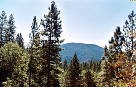
284:Southwest peak seen from the helipad to the south
559:Height and visual lines-of-sight are based on
729:
8:
667:Lake County Planning Department (May 1989),
736:
722:
714:
537:"Cobb Mountain-Southwest Peak, California"
18:
590:(Map). 1:24000. 7.5 Minute Topographic.
492:United States Department of the Interior
613:Mountains & Pioneers of Lake County
587:Whispering Pines quadrangle, California
440:
514:. USDA, Forest Service. Archived from
182:
149:
7:
910:Mountains of Lake County, California
573:Lake County Planning Department 1989
448:
446:
444:
676:(Preliminary Draft), archived from
483:Geographic Names Information System
399:accessible to the general public.
394:Much of Cobb Mountain lies within
14:
512:"Subsection M261Be Konocti Flows"
195:Cobb Mountain (the United States)
920:Mountains of Northern California
822:
181:
174:
148:
141:
27:
636:Stoneberg, David (2016-08-10).
488:United States Geological Survey
291:is the tallest mountain in the
337:can be seen from this summit.
321:Cobb Mountain – Southwest Peak
1:
329:; Southwest Peak lies on the
198:Show map of the United States
407:The mountain is named after
84:California county high point
454:"Cobb Mountain, California"
946:
61:3,160 ft (963 m)
820:
644:. Napa Valley, California
273:Clear Lake volcanic field
134:
114:38.8074045°N 122.740546°W
26:
930:Volcanoes of California
789:Mount Hood (California)
670:Cobb Mountain Area Plan
611:Mauldin, Henry (1995).
213:Lake County, California
119:38.8074045; -122.740546
925:Pleistocene lava domes
413:Henry County, Kentucky
311:, west of the town of
285:
165:Show map of California
162:Location in California
16:Mountain in California
283:
642:Napa Valley Register
915:Mayacamas Mountains
745:Mayacamas Mountains
293:Mayacamas Mountains
231:Mayacamas Mountains
110: /
809:Mount Saint Helena
774:Cow Mountain Ridge
326: NAVD 88
317:Mount Saint Helena
286:
49: NAVD 88
46:4723+ ft (1440+ m)
36:Highest point
897:
896:
849:Big Sulphur Creek
839:Arroyo Seco Creek
622:978-1-887400-22-0
373:Big Sulphur Creek
365:San Francisco Bay
328:
278:
277:
51:
937:
844:Big Canyon Creek
826:
814:Seigler Mountain
738:
731:
724:
715:
710:
690:
689:
688:
682:
675:
653:
652:
650:
649:
633:
627:
626:
608:
602:
601:
599:
598:
582:
576:
570:
564:
557:
551:
550:
548:
547:
533:
527:
526:
524:
523:
508:
502:
501:
499:
498:
474:
468:
467:
465:
464:
450:
361:Sacramento River
359:, then into the
350:Seigler Mountain
324:
245:Whispering Pines
226:
199:
185:
184:
178:
166:
152:
151:
145:
125:
124:
122:
121:
120:
115:
111:
108:
107:
106:
103:
47:
31:
19:
945:
944:
940:
939:
938:
936:
935:
934:
900:
899:
898:
893:
869:Mark West Creek
854:Calabazas Creek
827:
818:
784:Harbin Mountain
747:
742:
703:"Cobb Mountain"
701:
698:
693:
686:
684:
680:
673:
666:
662:
657:
656:
647:
645:
635:
634:
630:
623:
610:
609:
605:
596:
594:
584:
583:
579:
571:
567:
558:
554:
545:
543:
535:
534:
530:
521:
519:
510:
509:
505:
496:
494:
478:"Cobb Mountain"
476:
475:
471:
462:
460:
452:
451:
442:
437:
405:
305:
224:
204:
203:
202:
201:
200:
197:
196:
193:
192:
191:
190:
186:
169:
168:
167:
164:
163:
160:
159:
158:
157:
153:
118:
116:
112:
109:
104:
101:
99:
97:
96:
17:
12:
11:
5:
943:
941:
933:
932:
927:
922:
917:
912:
902:
901:
895:
894:
892:
891:
886:
881:
876:
871:
866:
861:
856:
851:
846:
841:
835:
833:
829:
828:
821:
819:
817:
816:
811:
806:
801:
796:
791:
786:
781:
776:
771:
766:
761:
759:Boggs Mountain
755:
753:
749:
748:
743:
741:
740:
733:
726:
718:
712:
711:
707:SummitPost.org
697:
696:External links
694:
692:
691:
663:
661:
658:
655:
654:
628:
621:
603:
577:
575:, p. 3.1.
565:
552:
541:Peakbagger.com
528:
503:
469:
458:Peakbagger.com
439:
438:
436:
433:
404:
401:
342:Boggs Mountain
315:. Like nearby
304:
301:
276:
275:
270:
268:Volcanic field
264:
263:
258:
252:
251:
247:
246:
240:
234:
233:
228:
220:
219:
210:
206:
205:
194:
188:
187:
180:
179:
173:
172:
171:
170:
161:
155:
154:
147:
146:
140:
139:
138:
137:
136:
135:
132:
131:
127:
126:
94:
88:
87:
81:
75:
74:
69:
63:
62:
59:
53:
52:
44:
38:
37:
33:
32:
24:
23:
15:
13:
10:
9:
6:
4:
3:
2:
942:
931:
928:
926:
923:
921:
918:
916:
913:
911:
908:
907:
905:
890:
887:
885:
882:
880:
877:
875:
872:
870:
867:
865:
862:
860:
857:
855:
852:
850:
847:
845:
842:
840:
837:
836:
834:
830:
825:
815:
812:
810:
807:
805:
804:Pyramid Ridge
802:
800:
797:
795:
794:Mount Konocti
792:
790:
787:
785:
782:
780:
777:
775:
772:
770:
767:
765:
764:Cobb Mountain
762:
760:
757:
756:
754:
750:
746:
739:
734:
732:
727:
725:
720:
719:
716:
708:
704:
700:
699:
695:
683:on 2021-04-23
679:
672:
671:
665:
664:
659:
643:
639:
632:
629:
624:
618:
614:
607:
604:
593:
589:
588:
581:
578:
574:
569:
566:
562:
556:
553:
542:
538:
532:
529:
518:on 2011-09-22
517:
513:
507:
504:
493:
489:
485:
484:
479:
473:
470:
459:
455:
449:
447:
445:
441:
434:
432:
430:
426:
421:
420:around 1860.
419:
414:
410:
402:
400:
397:
392:
390:
386:
382:
378:
377:Russian River
374:
370:
369:Pacific Ocean
366:
362:
358:
353:
351:
347:
343:
338:
336:
335:Snow Mountain
332:
327:
322:
318:
314:
310:
302:
300:
298:
294:
290:
289:Cobb Mountain
282:
274:
271:
269:
265:
262:
259:
257:
256:Mountain type
253:
248:
244:
241:
239:
235:
232:
229:
227:
221:
218:
214:
211:
207:
189:Cobb Mountain
177:
156:Cobb Mountain
144:
133:
128:
123:
95:
93:
89:
85:
82:
80:
76:
73:
72:Crockett Peak
70:
68:
64:
60:
58:
54:
50:
45:
43:
39:
34:
30:
25:
22:Cobb Mountain
20:
889:Scotts Creek
874:Middle Creek
864:Kelsey Creek
832:Watercourses
779:Mount Hannah
769:Cow Mountain
763:
706:
685:, retrieved
678:the original
669:
646:. Retrieved
641:
631:
612:
606:
595:. Retrieved
586:
580:
568:
561:Google Earth
555:
544:. Retrieved
540:
531:
520:. Retrieved
516:the original
506:
495:. Retrieved
481:
472:
461:. Retrieved
457:
422:
406:
393:
381:Kelsey Creek
354:
346:Mount Hannah
339:
320:
306:
288:
287:
225:Parent range
884:Putah Creek
799:Mahnke Peak
425:Valley Fire
418:Napa County
396:The Geysers
389:Cache Creek
357:Putah Creek
309:Lake County
117: /
105:122°44′26″W
92:Coordinates
67:Parent peak
904:Categories
879:Napa River
859:Cold Creek
687:2021-04-29
648:2021-10-29
597:2010-01-04
546:2009-07-05
522:2007-10-07
497:2009-07-05
463:2009-07-05
435:References
385:Clear Lake
367:, and the
297:California
102:38°48′27″N
57:Prominence
752:Mountains
409:John Cobb
261:Lava dome
130:Geography
42:Elevation
429:Cal Fire
303:Location
238:Topo map
209:Location
660:Sources
563:images.
403:History
250:Geology
79:Listing
619:
375:, the
363:, the
331:Sonoma
681:(PDF)
674:(PDF)
617:ISBN
592:USGS
348:and
313:Cobb
243:USGS
217:U.S.
86:42nd
295:of
906::
705:.
640:.
539:.
490:,
486:.
480:.
456:.
443:^
387:,
383:,
344:,
299:.
215:,
737:e
730:t
723:v
709:.
651:.
625:.
600:.
549:.
525:.
500:.
466:.
Text is available under the Creative Commons Attribution-ShareAlike License. Additional terms may apply.