551:
74:
269:
283:
58:
81:
249:
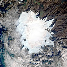
The Cook Ice Cap reaches a maximum elevation of 1,049 metres (3,442 ft) in its central area. It had a surface of approximately 500 km (190 sq mi) in 1963, having shrunk to about 400 km (150 sq mi) in recent times.
592:
631:
585:
518:
636:
73:
621:
578:
558:
125:
626:
306:
flow from the inner ice cap in a roughly radial pattern. At the feet of the snout of these outlet glaciers there are often
550:
118:
31:
616:
231:
354:
338:
362:
273:
258:
418:
378:
238:
234:
111:
410:
402:
394:
318:
at certain, mostly inland, locations. Only one of the glaciers originating in the Cook Ice Cap has its
434:
346:
327:
257:(1728–1779), on French navigational charts of the early 20th century this ice cap appears as 'Glacier
426:
370:
442:
386:
311:
530:
611:
534:
227:
562:
458:
319:
307:
286:
211:
268:
282:
605:
315:
35:
323:
57:
502:
254:
140:
127:
107:
17:
314:
of varying sizes. Further down the glacial meltwaters have formed numerous
303:
223:
97:
478:
566:
330:
in southeastern
Kerguelen's deeply indented coastline.
333:
The following are the main glaciers listed clockwise:
519:
La fonte spectaculaire du plus gros glacier français
516:Institut polaire français Paul Émile Victor :
188:
180:
172:
164:
156:
117:
103:
93:
43:
586:
8:
593:
579:
40:
512:
510:
281:
267:
632:Non-metropolitan France geography stubs
470:
7:
547:
545:
80:
637:Subantarctic island geography stubs
622:Landforms of the Kerguelen Islands
565:. You can help Knowledge (XXG) by
176:400 m (1,300 ft) average
25:
160:400 km (150 sq mi)
549:
79:
72:
56:
1:
253:Named after British explorer
32:Cook Glacier (South Georgia)
559:French Southern Territories
232:French Southern Territories
62:Aerial view of the ice cap.
653:
544:
538:11 September 1909, no 3472
382:(Glacier de l'Explorateur)
358:(Glacier Dumont d'Urville)
265:
168:28 kilometres (17 mi)
29:
196:
67:
55:
48:
479:"Calotte Glaciaire Cook"
355:Dumont d'Urville Glacier
274:Grande-Terre (Kerguelen)
30:Not to be confused with
561:location article is a
422:(Glacier Pierre Curie)
398:(Glacier de la Diozaz)
290:
277:
216:Calotte Glaciaire Cook
215:
50:Calotte Glaciaire Cook
627:Subantarctic glaciers
350:(Glacier de Chamonix)
285:
271:
239:Southern Indian Ocean
141:49.31389°S 69.04139°E
112:Southern Indian Ocean
419:Pierre Curie Glacier
289:at the southern end.
414:(Glacier Descartes)
406:(Glacier Lavoisier)
379:Explorateur Glacier
146:-49.31389; 69.04139
137: /
617:Glaciers of France
438:(Glacier Mariotte)
291:
278:
574:
573:
430:(Glacier Pasteur)
411:Descartes Glacier
403:Lavoisier Glacier
395:La Diozaz Glacier
374:(Glacier Naumann)
342:(Glacier Agassiz)
308:terminal moraines
295:
294:
228:Kerguelen Islands
200:
199:
27:Glacier in France
16:(Redirected from
644:
595:
588:
581:
553:
546:
539:
528:
522:
514:
505:
500:
494:
493:
491:
489:
475:
459:List of glaciers
446:(Glacier Cauchy)
435:Mariotte Glacier
390:(Glacier Ampère)
366:(Glacier Vallot)
347:Chamonix Glacier
328:Anse des Glaçons
287:Glacier terminus
264:
263:
152:
151:
149:
148:
147:
142:
138:
135:
134:
133:
130:
83:
82:
76:
60:
41:
21:
652:
651:
647:
646:
645:
643:
642:
641:
602:
601:
600:
599:
543:
542:
529:
525:
515:
508:
501:
497:
487:
485:
477:
476:
472:
467:
455:
450:
427:Pasteur Glacier
371:Naumann Glacier
339:Agassiz Glacier
300:
247:
184:Outlet glaciers
145:
143:
139:
136:
131:
128:
126:
124:
123:
89:
88:
87:
86:
85:
84:
63:
39:
28:
23:
22:
15:
12:
11:
5:
650:
648:
640:
639:
634:
629:
624:
619:
614:
604:
603:
598:
597:
590:
583:
575:
572:
571:
554:
541:
540:
535:L'Illustration
523:
506:
495:
469:
468:
466:
463:
462:
461:
454:
451:
449:
448:
443:Cauchy Glacier
440:
432:
424:
416:
408:
400:
392:
387:Ampère Glacier
384:
376:
368:
363:Vallot Glacier
360:
352:
344:
335:
316:outwash plains
299:
296:
293:
292:
279:
246:
243:
198:
197:
194:
193:
190:
186:
185:
182:
178:
177:
174:
170:
169:
166:
162:
161:
158:
154:
153:
121:
115:
114:
105:
101:
100:
95:
91:
90:
78:
77:
71:
70:
69:
68:
65:
64:
61:
53:
52:
46:
45:
26:
24:
14:
13:
10:
9:
6:
4:
3:
2:
649:
638:
635:
633:
630:
628:
625:
623:
620:
618:
615:
613:
610:
609:
607:
596:
591:
589:
584:
582:
577:
576:
570:
568:
564:
560:
555:
552:
548:
537:
536:
532:
527:
524:
521:
520:
513:
511:
507:
504:
499:
496:
484:
480:
474:
471:
464:
460:
457:
456:
452:
447:
444:
441:
439:
436:
433:
431:
428:
425:
423:
420:
417:
415:
412:
409:
407:
404:
401:
399:
396:
393:
391:
388:
385:
383:
380:
377:
375:
372:
369:
367:
364:
361:
359:
356:
353:
351:
348:
345:
343:
340:
337:
336:
334:
331:
329:
325:
321:
317:
313:
309:
305:
297:
288:
284:
280:
275:
270:
266:
262:
260:
256:
251:
244:
242:
240:
236:
233:
229:
225:
222:) is a large
221:
217:
213:
209:
205:
195:
191:
187:
183:
179:
175:
171:
167:
163:
159:
155:
150:
122:
120:
116:
113:
109:
106:
102:
99:
96:
92:
75:
66:
59:
54:
51:
47:
42:
37:
36:Cooke Glacier
33:
19:
567:expanding it
556:
533:
526:
517:
498:
488:25 September
486:. Retrieved
482:
473:
445:
437:
429:
421:
413:
405:
397:
389:
381:
373:
365:
357:
349:
341:
332:
324:Indian Ocean
312:dammed lakes
302:About sixty
301:
272:Location in
252:
248:
220:Glacier Cook
219:
208:Cook Glacier
207:
204:Cook Ice Cap
203:
201:
49:
44:Cook Ice Cap
18:Cook Glacier
531:Transpolair
503:GoogleEarth
237:of the far
144: /
119:Coordinates
606:Categories
465:References
259:Richthofen
255:James Cook
192:Retreating
132:69°02′29″E
129:49°18′50″S
245:Geography
173:Thickness
108:Kerguelen
612:Ice caps
483:Mapcarta
453:See also
320:terminus
304:glaciers
298:Glaciers
181:Terminus
104:Location
326:at the
322:in the
230:in the
226:in the
224:ice cap
98:Ice cap
212:French
189:Status
165:Length
557:This
310:with
563:stub
490:2016
235:zone
202:The
157:Area
94:Type
218:or
206:or
34:or
608::
509:^
481:.
261:'
241:.
214::
110:,
594:e
587:t
580:v
569:.
492:.
276:.
210:(
38:.
20:)
Text is available under the Creative Commons Attribution-ShareAlike License. Additional terms may apply.