414:
48:
32:
396:
301:” of a maximum height of 24.8 metres (81 ft) above sea level and topped with a plateau. The western side of the island has a “gentle” slope while the remaining sides are “sheer cliffs” dropping to “low-lying rock shelves”. The top of the island and its western side are overlaid by a “shallow cover of topsoil.” A “semi-permanent freshwater basin” is located in the island's northern side.
506:
55:
386:
did not know of any sites on the island of significance to
Aboriginal people, the Aboriginal community did know of a "number of Aboriginal mythological stories" and of "some sites" associated with the island. For example, the island is known by the "Coodjinburra clan of the Bungjalung people" as
475:
reported the sighting of a
European vessel, wrecked on the island in the 16th century. In 2008, two fishermen, Joel Coombs and Malcolm Anable, were rescued from nearby the island, and later hospitalised, after they were thrown overboard as a result of their boat overturning.
321:
because of the “exposed rocky nature” of the island's coastline and “frequently rough sea conditions.” Access is not promoted to “protect roosting birds and the nest burrows of wedge-tailed shearwaters which are fragile and can easily collapse under foot traffic.”
608:
483:
349:
413:
335:
As of 2011, there were twenty five native plant species which occupied, in part, three distinct habitats - “elevated locations; rocky crevices; and lower sites at the base of cliffs.”
938:
487:
47:
722:
983:
180:
318:
106:
456:
anchored at the island to take refuge from southerly winds. Two crew members then visited the island and named it Turtle Island, after finding
347:
animals were represented by 25 species of birds and two reptile species. These included 12 bird species listed as migratory species under the
988:
786:
621:
978:
773:
505:
861:
433:
in 1770. Cook charted the coastline of the island, but made no attempt at settlement. Cook then continued sailing north along the
245:
218:
778:
693:
648:
465:
430:
418:
383:
532:
434:
528:
446:
616:, NSW National Parks and Wildlife Service, Part of the Department of Environment, Climate Change and Water, 2011,
561:
399:
31:
395:
934:
736:
512:
851:
993:
235:
883:
491:
912:
963:
800:
792:
782:
617:
371:
479:
In 1970, the name Cook Island was officially assigned to the island, replacing Cooks Island.
293:
Cook Island is formed of “rocks from the
Lismore Basalt Group, formed by lava flows from the
856:
687:
309:
In 2011, the average annual rainfall was reported as being 1,470 millimetres (58 in).
837:
461:
379:
269:
173:
740:
768:
524:
425:
The first recorded
European sighting of Cook Island was made by the English navigator
972:
658:
442:
294:
272:
located on the state's north coast about 600 metres (2,000 ft) north-east of
374:
nation." Also, the island is the subject of "traditional knowledge" held by the
457:
277:
273:
185:
915:. New South Wales Department of Environment and Climate Change. 3 October 2008
714:
683:
453:
426:
367:
344:
79:
796:
121:
108:
825:
804:
472:
438:
297:
approximately 20 million years ago.” The Island is a “protrusion of eroded
210:
161:
94:
833:
515:
406:
375:
653:
249:
222:
366:
Cook Island is located within the area historically occupied by the "
298:
265:
264:, formerly Cooks Island, Turtle Island and Joong-urra-narrian, is an
412:
394:
527:
status since 1959 and since 1967, it has been located within the
460:
and an unidentified shipwreck. Five years later, British admiral
353:
and seven fauna species listed as threatened in New South Wales.
468:
and named the island, Cook's Isle, the name that has persisted.
387:
Joongurra-Narrian which translates as "the place of pelicans".
531:. The waters adjoining the island have been located within the
29:
350:
Environment
Protection and Biodiversity Conservation Act 1999
484:
New South Wales
Department of Environment and Climate Change
36:
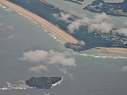
Aerial view of Cook Island and Fingal Head, New South Wales
317:
Access to the island is considered to be not “easy” by the
964:
Northern Rivers
Geology Blog - Fingal Head and Cook Island
276:
and 4 kilometres (2.5 mi) south-east of the town of
913:"Marine debris clean-up at Cook Island Aquatic Reserve"
777:. Vol. 2. Canberra: National Centre of Biography,
523:
The entirety of Cook Island has been the subject of
562:"Cook Island - Geographical Names Register Extract"
232:
209:
204:
196:
191:
179:
169:
153:
145:
137:
100:
90:
85:
75:
26:
556:
554:
552:
550:
548:
939:New South Wales Department of Primary Industries
852:"Tweed River fishermen rescued after boat flips"
490:, as well. It is under the jurisdiction of the
482:Since 1998, the island has been managed by the
610:Cook Island Nature Reserve, Plan of Management
8:
21:
678:
676:
566:Geographical Names Board of New South Wales
907:
905:
723:State Records Authority of New South Wales
30:
20:
518:of Cook Island, in 2009, from Fingal Head
449:, after he was nearly shipwrecked there.
382:aboriginal people. As of 2011, while the
643:
641:
639:
742:Geographical memoirs on New South Wales
544:
319:NSW National Parks and Wildlife Service
715:Oxley, John Joseph William Molesworth
603:
7:
755:Barron Field's Geographical Memoirs.
601:
599:
597:
595:
593:
591:
589:
587:
585:
583:
16:Island in New South Wales, Australia
890:. News Corporation. 18 October 2008
494:, who hold annual clean-up events.
54:
774:Australian Dictionary of Biography
568:. NSW Government. 24 December 1970
14:
984:Uninhabited islands of Australia
504:
488:Department of Primary Industries
441:and named two nearby landmarks,
53:
46:
779:Australian National University
769:"Rous, Henry John (1795–1877)"
1:
884:"Men clung to boat for hours"
694:National Library of Australia
384:Government of New South Wales
989:Tweed Heads, New South Wales
295:Mount Warning Shield Volcano
533:Cook Island Aquatic Reserve
429:, who sighted the coast of
268:in the Australian state of
67:Location in New South Wales
1010:
979:Islands of New South Wales
529:Cook Island Nature Reserve
452:In 1823, English explorer
149:24.8 m (81.4 ft)
158:
41:
486:and since 2004, by the
471:Australian spearfisher
767:Daley, Louise (1967).
498:Protected areas status
422:
410:
289:Geology and topography
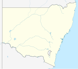
205:Additional information
146:Highest elevation
141:4.6 ha (11 acres)
122:28.19833°S 153.58444°E
689:The Endeavour Journal
416:
398:
234: • Summer (
181:Local government area
127:-28.19833; 153.58444
717:(31 October 1823).
492:Tweed Shire Council
118: /
23:
423:
411:
362:Aboriginal history
864:. 18 October 2008
788:978-0-522-84459-7
661:. 8 February 2004
623:978-1-74293-205-7
259:
258:
1001:
951:
950:
948:
946:
931:
925:
924:
922:
920:
909:
900:
899:
897:
895:
888:The Courier-Mail
880:
874:
873:
871:
869:
862:News Corporation
857:The Courier-Mail
848:
842:
841:
822:
816:
815:
813:
811:
764:
758:
757:
752:
750:
733:
727:
726:
711:
705:
704:
702:
700:
680:
671:
670:
668:
666:
645:
634:
633:
632:
630:
615:
605:
578:
577:
575:
573:
558:
508:
391:European history
239:
133:
132:
130:
129:
128:
123:
119:
116:
115:
114:
111:
57:
56:
50:
34:
24:
1009:
1008:
1004:
1003:
1002:
1000:
999:
998:
969:
968:
960:
955:
954:
944:
942:
933:
932:
928:
918:
916:
911:
910:
903:
893:
891:
882:
881:
877:
867:
865:
850:
849:
845:
838:South Australia
824:
823:
819:
809:
807:
789:
766:
765:
761:
748:
746:
735:
734:
730:
713:
712:
708:
698:
696:
686:(16 May 1770).
682:
681:
674:
664:
662:
647:
646:
637:
628:
626:
624:
613:
607:
606:
581:
571:
569:
560:
559:
546:
541:
521:
520:
519:
514:
509:
500:
462:Henry John Rous
393:
364:
359:
341:
333:
328:
326:Flora and fauna
315:
307:
291:
286:
270:New South Wales
255:
233:
228:
174:New South Wales
165:
126:
124:
120:
117:
112:
109:
107:
105:
104:
71:
70:
69:
68:
65:
64:
63:
62:
58:
37:
17:
12:
11:
5:
1007:
1005:
997:
996:
991:
986:
981:
971:
970:
967:
966:
959:
958:External links
956:
953:
952:
926:
901:
875:
843:
817:
787:
759:
728:
706:
672:
635:
622:
579:
543:
542:
540:
537:
525:protected area
511:
510:
503:
502:
501:
499:
496:
392:
389:
370:people of the
363:
360:
358:
355:
340:
337:
332:
329:
327:
324:
314:
311:
306:
303:
290:
287:
285:
282:
257:
256:
254:
253:
242:
240:
230:
229:
227:
226:
215:
213:
207:
206:
202:
201:
198:
194:
193:
189:
188:
183:
177:
176:
171:
167:
166:
159:
156:
155:
154:Administration
151:
150:
147:
143:
142:
139:
135:
134:
102:
98:
97:
92:
88:
87:
83:
82:
77:
73:
72:
66:
60:
59:
52:
51:
45:
44:
43:
42:
39:
38:
35:
27:
15:
13:
10:
9:
6:
4:
3:
2:
1006:
995:
992:
990:
987:
985:
982:
980:
977:
976:
974:
965:
962:
961:
957:
941:. 2 July 2004
940:
936:
935:"Cook Island"
930:
927:
914:
908:
906:
902:
889:
885:
879:
876:
863:
859:
858:
853:
847:
844:
839:
835:
831:
830:Shark Hunters
827:
821:
818:
806:
802:
798:
794:
790:
784:
780:
776:
775:
770:
763:
760:
756:
744:
743:
738:
737:Field, Barron
732:
729:
724:
720:
716:
710:
707:
695:
691:
690:
685:
679:
677:
673:
660:
659:Fairfax Media
657:. Melbourne:
656:
655:
650:
649:"Fingal Head"
644:
642:
640:
636:
625:
619:
612:
611:
604:
602:
600:
598:
596:
594:
592:
590:
588:
586:
584:
580:
567:
563:
557:
555:
553:
551:
549:
545:
538:
536:
534:
530:
526:
517:
513:
507:
497:
495:
493:
489:
485:
480:
477:
474:
469:
467:
464:surveyed the
463:
459:
455:
450:
448:
444:
443:Mount Warning
440:
436:
435:eastern coast
432:
428:
420:
415:
408:
404:
402:
397:
390:
388:
385:
381:
377:
373:
369:
361:
356:
354:
352:
351:
346:
338:
336:
330:
325:
323:
320:
312:
310:
304:
302:
300:
296:
288:
283:
281:
279:
275:
271:
267:
263:
251:
247:
244:
243:
241:
237:
231:
224:
220:
217:
216:
214:
212:
208:
203:
199:
195:
190:
187:
184:
182:
178:
175:
172:
168:
164:
163:
157:
152:
148:
144:
140:
136:
131:
103:
99:
96:
93:
89:
84:
81:
78:
74:
49:
40:
33:
28:Native name:
25:
19:
943:. Retrieved
929:
917:. Retrieved
892:. Retrieved
887:
878:
866:. Retrieved
855:
846:
840:: Rigby Ltd.
829:
820:
808:. Retrieved
772:
762:
754:
747:. Retrieved
741:
731:
718:
709:
697:. Retrieved
688:
663:. Retrieved
652:
629:17 September
627:, retrieved
609:
572:17 September
570:. Retrieved
565:
535:since 1998.
522:
481:
478:
470:
451:
447:Point Danger
424:
421:, circa 1934
400:
365:
348:
343:As of 2011,
342:
334:
316:
308:
292:
261:
260:
192:Demographics
160:
18:
994:Tweed Shire
745:. J. Murray
719:Item 2/8093
684:Cook, James
466:Tweed River
458:sea turtles
431:Fingal Head
419:Fingal Head
284:Description
278:Tweed Heads
274:Fingal Head
262:Cook Island
186:Tweed Shire
125: /
113:153°35′04″E
101:Coordinates
61:Cook Island
22:Cook Island
973:Categories
826:Cropp, Ben
539:References
454:John Oxley
427:James Cook
417:View from
372:Bundjalung
368:Minjungbal
345:vertebrate
197:Population
110:28°11′54″S
80:James Cook
797:1833-7538
473:Ben Cropp
439:Australia
401:Endeavour
211:Time zone
162:Australia
95:Coral Sea
86:Geography
76:Etymology
834:Adelaide
828:(1964).
805:70677943
739:(1825).
516:Panorama
407:Cooktown
380:Yugambeh
376:Githabul
91:Location
945:10 July
919:10 July
894:10 July
868:10 July
810:10 July
749:10 July
699:10 July
665:10 July
654:The Age
409:Harbour
403:replica
357:History
305:Climate
803:
795:
785:
620:
313:Access
299:basalt
266:island
250:UTC+11
223:UTC+10
614:(PDF)
339:Fauna
331:Flora
170:state
947:2009
921:2009
896:2009
870:2009
812:2009
801:OCLC
793:ISSN
783:ISBN
751:2009
701:2009
667:2009
631:2019
618:ISBN
574:2019
445:and
378:and
246:AEDT
219:AEST
138:Area
437:of
405:in
236:DST
975::
937:.
904:^
886:.
860:.
854:.
836:,
832:.
799:.
791:.
781:.
771:.
753:.
721:.
692:.
675:^
651:.
638:^
582:^
564:.
547:^
280:.
949:.
923:.
898:.
872:.
814:.
725:.
703:.
669:.
576:.
252:)
248:(
238:)
225:)
221:(
200:0
Text is available under the Creative Commons Attribution-ShareAlike License. Additional terms may apply.