203:
307:
121:
29:
280:
253:
128:
194:
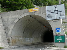
nearby the northwest through a tunnel at 1254 meters and drilled in 1979 and a length of 769 m. It replaces a previous work from 1866 and parallel to it. True neck, the top of the ridge overlooking the tunnel, is for its part to 1367 meters and is within walking distance. The hamlet of
Rousset to
219:
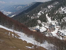
and six ski lifts which are serving thirty tracks offering all levels of difficulty. Nearby is also a snow stadium, the stadium
Raphael Poiree, with tracks of Nordic skiing and dog sledding in the winter. The cervix is the start of the Great Crossing of Vercors (GTV), which leads to
228:
83:
120:
186:
and the mountain is 19 km away from the town with the same name. The
Rousset Pass is one of the few crossing points, with the
240:
The mountain pass was visited three times by the Tour de France in 1984, 1996 and 1998, with the results of the winners here:
357:
352:
155:
76:
174:
and has a height of 1.254 meter, the mountain pass is popular among cyclists and the area around it for winter sports.
224:, cross country skiing during the winter and mountain biking during the summer, through the high plateaus of Vercors.
202:
258:
163:
196:
187:
337:
299:
272:
245:
191:
36:
312:
285:
221:
171:
69:
64:
53:
346:
183:
190:
as an allowing access to the South-Vercors. It connects precisely Die south to
28:
98:
85:
216:
159:
49:
227:
167:
57:
226:
201:
182:
The mountain pass is situated in the arrondissement of
75:
63:
45:
35:
21:
195:which the collar belongs to the municipality of
338:A Few info at Ladromemontagne.fr (in English)
215:There is also an Alpine ski resort at with a
8:
18:
127:
7:
154:is a mountain pass located in the
14:
318:
305:
278:
251:
231:Col de Rousset during the winter
126:
119:
27:
291:
264:
1:
156:Vercors Regional Natural Park
206:Tunnel of the Col de Rousset
199:, in the Drôme department.
374:
170:, and it is a part of the
114:
26:
99:44.840611°N 5.4060028°E
16:Mountain pass in France
232:
211:Station Col de Rousset
207:
197:Saint-Agnan-en-Vercors
358:Mountains of the Alps
230:
205:
259:Jean-René Bernaudeau
164:Auvergne-Rhône-Alpes
104:44.840611; 5.4060028
192:Vassieux-en-Vercors
95: /
353:Mountains of Isère
233:
208:
188:Col de la Bataille
148:
147:
365:
322:
320:
311:
309:
308:
295:
293:
286:Laurent Brochard
284:
282:
281:
268:
266:
257:
255:
254:
130:
129:
123:
110:
109:
107:
106:
105:
100:
96:
93:
92:
91:
88:
31:
19:
373:
372:
368:
367:
366:
364:
363:
362:
343:
342:
334:
329:
316:
306:
304:
289:
279:
277:
262:
252:
250:
238:
222:Villard-de-Lans
213:
180:
144:
143:
142:
141:
138:
137:
136:
135:
131:
103:
101:
97:
94:
89:
86:
84:
82:
81:
17:
12:
11:
5:
371:
369:
361:
360:
355:
345:
344:
341:
340:
333:
332:External links
330:
328:
325:
324:
323:
313:Stuart O'Grady
296:
269:
237:
236:Tour de France
234:
212:
209:
179:
176:
172:Vercors Massif
152:Col de Rousset
146:
145:
139:
134:Col de Rousset
133:
132:
125:
124:
118:
117:
116:
115:
112:
111:
79:
73:
72:
70:Vercors Massif
67:
61:
60:
47:
43:
42:
39:
33:
32:
24:
23:
22:Col de Rousset
15:
13:
10:
9:
6:
4:
3:
2:
370:
359:
356:
354:
351:
350:
348:
339:
336:
335:
331:
326:
314:
302:
301:
297:
287:
275:
274:
270:
260:
248:
247:
243:
242:
241:
235:
229:
225:
223:
218:
210:
204:
200:
198:
193:
189:
185:
177:
175:
173:
169:
165:
161:
157:
153:
122:
113:
108:
90:05°24′21.61″E
80:
78:
74:
71:
68:
66:
62:
59:
55:
51:
48:
44:
40:
38:
34:
30:
25:
20:
300:Edition 1998
298:
273:Edition 1996
271:
246:Edition 1984
244:
239:
214:
181:
151:
149:
87:44°50′26.2″N
102: /
77:Coordinates
54:Rhône-Alpes
347:Categories
327:References
217:funicular
37:Elevation
303: :
276: :
249: :
178:Location
46:Location
41:1.254 m
315:
310:
288:
283:
261:
256:
168:France
140:France
58:France
160:Drôme
65:Range
50:Isère
150:The
319:AUS
292:FRA
265:FRA
184:Die
349::
166:,
162:,
158:,
56:,
52:,
321:)
317:(
294:)
290:(
267:)
263:(
Text is available under the Creative Commons Attribution-ShareAlike License. Additional terms may apply.