129:
26:
136:
208:
From the south, the road to the pass follows the D25 from its junction with the D1091 to the east of Le Freney-d'Oisans. From here, the road is 12.8 km (8.0 mi) km long, climbing 954 m (3,130 ft) at an average of 7.5%, although the first kilometre to Mizoën has a gradient of 11.5%
220:
criticized the decision of the Tour de France organisers to use the pass, saying: "The road is old and narrow. It’s a bad road, no guardrails. A mistake could see you falling straight down 30 metres. It's irresponsible to send us there." Martin repeated his criticisms on the eve of the Tour de
204:
From Alpe d'Huez, the route used on the Tour de France follows an unnamed road initially, descending to 1,765 m (5,791 ft) before the final climb to the summit which is 3 km (1.9 mi) long at an average gradient of 7.8%.
223:
It’s still the same descent. … It’s quite nasty and a really dangerous descent. We’ve made a lot of comments already in the media, so I really hope the organization heard it.
410:
91:
308:
415:
357:
334:
259:
390:
420:
128:
285:
84:
196:
bicycle race as this loops round to enable the cyclists to climb the Alpe d'Huez twice in the same stage.
217:
177:
185:
395:
213:
193:
36:
382:
228:
232:
166:
73:
236:
170:
68:
25:
404:
263:
162:
209:
and the maximum gradient is 13.5% at 3 km (1.9 mi) from the summit.
106:
93:
396:
Cycling up to the Col de
Sarenne: data, profile, map, photos and description
312:
227:
In the race, the summit was crossed first by a group of four riders, led by
181:
231:. On the descent, van Garderen had a technical problem with his bike, and
235:
left the road on a corner before going on to win the stage at the top of
189:
174:
57:
61:
77:
180:
of France. The pass connects Alpe d'Huez with the villages of
192:
valley. The road over the pass was used on Stage 18 of the
309:"Tony Martin says the Tour's Col de Sarenne is dangerous"
169:
massif, approximately 9 km (6 mi) east of
83:
67:
53:
45:
35:
18:
391:Cycle the Col de Sarenne (www.morethan21bends.com)
358:"Riblon wins stage 18 of the 2013 Tour de France"
335:"'Dangerous' Col de Sarenne concerns Tour riders"
254:
252:
8:
212:The passage over the summit was used in the
286:"Col de Sarenne: crossroad Col de Sarenne"
15:
383:Le col de Sarenne dans le Tour de France
411:Mountain passes of Auvergne-Rhône-Alpes
248:
135:
7:
216:; following that race, German rider
161:(1,999 m (6,558 ft)) is a
14:
356:Holcombe, Brian (18 July 2013).
262:. Tour de France. Archived from
134:
127:
24:
333:Brown, Gregor (17 July 2013).
307:Brown, Gregor (12 June 2013).
1:
260:"Stage 18: Gap / Alpe-d'Huez"
416:Mountain passes of the Alps
437:
148:Location of Col de Sarenne
122:
23:
200:Details of the climb
107:45.08750°N 6.14917°E
214:2013 Tour de France
194:2013 Tour de France
103: /
421:Landforms of Isère
229:Tejay van Garderen
186:Le Freney-d'Oisans
49:Unnamed road / D25
41:1,999 m (6,558 ft)
288:. climbbybike.com
233:Christophe Riblon
156:
155:
112:45.08750; 6.14917
428:
387:
370:
369:
367:
365:
353:
347:
346:
344:
342:
330:
324:
323:
321:
319:
304:
298:
297:
295:
293:
282:
276:
275:
273:
271:
256:
138:
137:
131:
118:
117:
115:
114:
113:
108:
104:
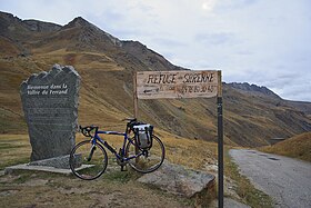
101:
100:
99:
96:
28:
16:
436:
435:
431:
430:
429:
427:
426:
425:
401:
400:
385:
379:
374:
373:
363:
361:
355:
354:
350:
340:
338:
332:
331:
327:
317:
315:
306:
305:
301:
291:
289:
284:
283:
279:
269:
267:
266:on 11 July 2013
258:
257:
250:
245:
202:
167:Grandes Rousses
165:located in the
152:
151:
150:
149:
146:
145:
144:
143:
139:
111:
109:
105:
102:
97:
94:
92:
90:
89:
74:Grandes Rousses
31:
12:
11:
5:
434:
432:
424:
423:
418:
413:
403:
402:
399:
398:
393:
388:
378:
377:External links
375:
372:
371:
348:
325:
299:
277:
247:
246:
244:
241:
201:
198:
159:Col de Sarenne
154:
153:
147:
142:Col de Sarenne
141:
140:
133:
132:
126:
125:
124:
123:
120:
119:
87:
81:
80:
71:
65:
64:
55:
51:
50:
47:
43:
42:
39:
33:
32:
30:Col de Sarenne
29:
21:
20:
19:Col de Sarenne
13:
10:
9:
6:
4:
3:
2:
433:
422:
419:
417:
414:
412:
409:
408:
406:
397:
394:
392:
389:
384:
381:
380:
376:
359:
352:
349:
336:
329:
326:
314:
310:
303:
300:
287:
281:
278:
265:
261:
255:
253:
249:
242:
240:
238:
234:
230:
225:
224:
219:
215:
210:
206:
199:
197:
195:
191:
187:
183:
179:
176:
172:
168:
164:
163:mountain pass
160:
130:
121:
116:
88:
86:
82:
79:
75:
72:
70:
66:
63:
59:
56:
52:
48:
44:
40:
38:
34:
27:
22:
17:
362:. Retrieved
351:
339:. Retrieved
328:
316:. Retrieved
302:
290:. Retrieved
280:
268:. Retrieved
264:the original
226:
222:
211:
207:
203:
158:
157:
46:Traversed by
386:(in French)
237:Alpe d'Huez
218:Tony Martin
171:Alpe d'Huez
110: /
85:Coordinates
405:Categories
360:. velonews
337:. velonews
243:References
178:department
313:Velo News
95:45°5′15″N
37:Elevation
221:France:
190:Romanche
98:6°8′57″E
54:Location
364:19 July
341:19 July
318:13 July
292:13 July
270:13 July
188:in the
173:in the
182:Mizoën
62:France
175:Isère
69:Range
58:Isère
366:2013
343:2013
320:2013
294:2013
272:2013
184:and
78:Alps
407::
311:.
251:^
239:.
76:/
60:,
368:.
345:.
322:.
296:.
274:.
Text is available under the Creative Commons Attribution-ShareAlike License. Additional terms may apply.