51:
618:
37:
604:
388:
481:
460:
231:
555:
360:. Approximately, 1.6 miles (2.6 km) northeast of the railroad crossing, SH 23 leaves Phillips County and enters Sedgwick County. About 0.8 miles (1.3 km) farther northeast, SH 23 reaches its northern terminus at County Road 63.2 (CR 63.2), which runs along the Colorado-Nebraska state line. (The highway continues northeast into Nebraska as
793:
487:
466:
104:
246:
561:
123:
355:
Continuing northeast along the north side of the BNSF tracks from
Amherst, SH 23 travel through more agricultural area and connects with several more county roads. Roughly 5.6 miles (9.0 km) northeast of Amherst, the route has a slight S curve, crossing over the tracks in the middle of the
683:
329:. Howitt Street heads west along the northern edge of the Phillips County Raceway.) From its southern terminus SH 23 heads very briefly due east (immediately leaving Holyoke) until it reaches the
402:(I-76), which runs less than 20 miles (32 km) to the north of the route, and to match Nebraska's connecting highway number (NE-23), the former SH 176 was renumbered as SH 23 in 1989.
653:
822:
817:
309:
SH 23 begins at an intersection with US 385 (North
Interocean Avenue) and Howitt Street in Holyoke, near the city's northern edge. (US 385 heads north toward
783:
214:
199:
71:
812:
797:
631:
209:
204:
710:
714:
398:. The highway was decommissioned in 1952 but was reinstated in 1968 (still as SH 176). To avoid confusion with
491:
470:
395:
286:
107:
517:
433:
399:
278:
274:
249:
234:
174:
170:
542:
495:
314:
345:
532:
369:
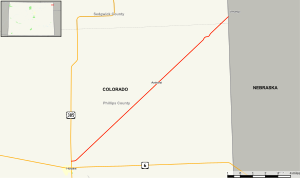
379:, with no major junctions and, other than Holyoke and Amherst, does not pass near any populated paces.
507:
340:. About 9.6 miles (15.4 km) from the beginning of the route, and after connecting with multiple
326:
565:
474:
361:
310:
294:
126:
376:
50:
774:
609:
569:
438:
365:
349:
337:
290:
111:
503:
322:
623:
499:
357:
341:
318:
806:
333:
270:
150:
330:
17:
688:
719:(Tyopgraphic map). 1:24,000. Reston, Virginia: United States Geological Survey
599:
792:
739:
387:
580:
573:
536:
298:
282:
160:
130:
56:
36:
336:
and then turns northeast to run parallel with the tracks through rural
782:
394:
The route established in about 1935, but was originally designated as
386:
372:, Nebraska and south along the state line toward US 6.)
588:
1.000 mi = 1.609 km; 1.000 km = 0.621 mi
770:
765:
368:. CR 63.2 heads north along the state line toward
184:
166:
156:
146:
141:
117:
98:
93:
85:
77:
64:
32:
784:Template:Attached KML/Colorado State Highway 23
8:
823:Transportation in Sedgwick County, Colorado
818:Transportation in Phillips County, Colorado
317:(US 6) in Holyoke, and then on toward
409:
223:
787:
452:Continuation west from southern terminus
27:State highway in Colorado, United States
678:
676:
674:
672:
670:
656:. Colorado Department of Transportation
642:
494:south (North Interocean Avenue) –
375:For its entire length of SH 23 is
281:counties in the northeastern corner of
738:Salek, Matthew E. (January 30, 2010).
29:
654:"Segment Descriptions for Highway 23"
648:
646:
551:
530:
524:
456:
448:
442:
7:
632:List of state highways in Colorado
59:with SH 23 highlighted in red
25:
791:
616:
602:
559:
553:
485:
479:
464:
458:
344:, SH 23 passed through the
269:) is a 17.7-mile (28.5 km)
244:
229:
121:
102:
81:17.7 mi (28.5 km)
49:
35:
711:United States Geological Survey
285:, United States, that connects
541:County Road 63.2 south –
531:County Road 63.2 north –
1:
193:Colorado State Highway System
579:Continuation northeast into
839:
813:State highways in Colorado
313:and south to connect with
798:Colorado State Highway 23
587:
578:
546:
527:
521:
516:
511:
451:
445:
437:
432:
427:
424:
421:
418:
415:
412:
222:
189:
180:
137:
69:
48:
740:"Colorado Routes 20–39"
346:census-designated place
583:from northern terminus
391:
800:at Wikimedia Commons
390:
788:KML is from Wikidata
55:Map of northeastern
406:Major intersections
364:and quickly enters
362:Nebraska Highway 23
295:Nebraska Highway 23
18:Colorado Highway 23
449:Howitt Street west
400:Interstate 76
392:
796:Media related to
684:"CO-23, Colorado"
610:U.S. Roads portal
593:
592:
547:Northern terminus
512:Southern terminus
338:agricultural area
305:Route description
289:(US 385) in
260:
259:
256:
255:
65:Route information
16:(Redirected from
830:
795:
778:
751:
750:
748:
746:
735:
729:
728:
726:
724:
707:
701:
700:
698:
696:
680:
665:
664:
662:
661:
650:
626:
621:
620:
619:
612:
607:
606:
605:
564:
563:
562:
557:
556:
490:
489:
488:
483:
482:
469:
468:
467:
462:
461:
410:
263:State Highway 23
252:
248:
247:
237:
233:
232:
224:
125:
124:
106:
105:
53:
42:State Highway 23
39:
30:
21:
838:
837:
833:
832:
831:
829:
828:
827:
803:
802:
789:
786:
781:
780:
779:
763:
759:
754:
744:
742:
737:
736:
732:
722:
720:
709:
708:
704:
694:
692:
682:
681:
668:
659:
657:
652:
651:
644:
640:
624:Colorado portal
622:
617:
615:
608:
603:
601:
598:
589:
560:
558:
554:
552:
540:
486:
484:
480:
478:
477:
465:
463:
459:
457:
408:
385:
307:
245:
243:
230:
228:
122:
103:
94:Major junctions
60:
44:
43:
40:
28:
23:
22:
15:
12:
11:
5:
836:
834:
826:
825:
820:
815:
805:
804:
762:
761:
760:
758:
757:External links
755:
753:
752:
730:
702:
666:
641:
639:
636:
635:
634:
628:
627:
613:
597:
594:
591:
590:
585:
584:
577:
549:
548:
545:
529:
526:
523:
520:
514:
513:
510:
454:
453:
450:
447:
444:
441:
436:
430:
429:
426:
423:
420:
417:
414:
407:
404:
384:
381:
358:level crossing
334:railway tracks
306:
303:
287:U.S. Route 385
258:
257:
254:
253:
240:
238:
220:
219:
218:
217:
212:
207:
202:
196:
195:
187:
186:
185:Highway system
182:
181:
178:
177:
168:
164:
163:
158:
154:
153:
148:
144:
143:
139:
138:
135:
134:
119:
118:North end
115:
114:
100:
99:South end
96:
95:
91:
90:
87:
83:
82:
79:
75:
74:
70:Maintained by
67:
66:
62:
61:
54:
46:
45:
41:
34:
33:
26:
24:
14:
13:
10:
9:
6:
4:
3:
2:
835:
824:
821:
819:
816:
814:
811:
810:
808:
801:
799:
794:
785:
776:
772:
768:
767:
756:
741:
734:
731:
718:
717:
712:
706:
703:
691:
690:
685:
679:
677:
675:
673:
671:
667:
655:
649:
647:
643:
637:
633:
630:
629:
625:
614:
611:
600:
595:
586:
582:
575:
571:
567:
550:
544:
538:
534:
519:
515:
509:
505:
501:
497:
493:
476:
473:north –
472:
455:
440:
435:
431:
411:
405:
403:
401:
397:
389:
382:
380:
378:
377:two-lane road
373:
371:
367:
363:
359:
353:
351:
347:
343:
339:
335:
332:
328:
324:
320:
316:
312:
304:
302:
300:
296:
292:
288:
284:
280:
276:
272:
271:state highway
268:
264:
251:
241:
239:
236:
226:
225:
221:
216:
213:
211:
208:
206:
203:
201:
198:
197:
194:
191:
190:
188:
183:
179:
176:
172:
169:
165:
162:
159:
155:
152:
151:United States
149:
145:
140:
136:
132:
128:
120:
116:
113:
109:
101:
97:
92:
88:
84:
80:
76:
73:
68:
63:
58:
52:
47:
38:
31:
19:
790:
764:
743:. Retrieved
733:
721:. Retrieved
715:
705:
693:. Retrieved
687:
658:. Retrieved
568:east –
425:Destinations
393:
374:
354:
342:county roads
331:BNSF Railway
315:U.S. Route 6
308:
266:
262:
261:
192:
89:1989–present
689:Google Maps
533:Big Springs
492:US 385
471:US 385
396:SH 176
370:Big Springs
356:curve at a
108:US 385
807:Categories
723:October 6,
695:October 5,
660:2008-03-26
638:References
508:Burlington
327:Burlington
297:(N-23) in
267:SH 23
250:US 24
235:SH 22
200:Interstate
133:state line
543:US 6
496:US 6
475:Julesburg
311:Julesburg
766:KML file
745:March 6,
713:(1973).
596:See also
581:Nebraska
574:Nebraska
537:Nebraska
518:Sedgwick
434:Phillips
416:Location
299:Nebraska
283:Colorado
279:Sedgwick
275:Phillips
175:Sedgwick
171:Phillips
167:Counties
161:Colorado
142:Location
131:Nebraska
57:Colorado
716:Holyoke
686:(Map).
570:Venango
522:
439:Holyoke
383:History
366:Venango
350:Amherst
291:Holyoke
147:Country
129:at the
112:Holyoke
86:Existed
528:28.175
525:17.507
504:Idalia
413:County
325:, and
323:Idalia
215:Scenic
78:Length
446:0.000
443:0.000
428:Notes
293:with
210:State
157:State
775:help
771:edit
747:2010
725:2022
697:2022
566:N-23
500:Wray
319:Wray
277:and
127:N-23
72:CDOT
348:of
273:in
110:in
809::
773:•
669:^
645:^
506:,
502:,
498:,
422:km
419:mi
352:.
321:,
301:.
242:→
227:←
205:US
173:,
777:)
769:(
749:.
727:.
699:.
663:.
576:)
572:(
539:)
535:(
265:(
20:)
Text is available under the Creative Commons Attribution-ShareAlike License. Additional terms may apply.