62:
681:
79:
104:
366:
991:
1011:
1001:
111:
86:
254:
on
December 30, 1970. The College Hill local historic district, established in 1960 (and expanded in 1990), partially overlaps the national landmark district. Properties within the local historic district are regulated by the city's historic district zoning ordinance, and cannot be altered without
1060:
715:
710:
891:
886:
967:
957:
861:
622:
805:
779:
769:
705:
695:
846:
952:
947:
841:
784:
932:
700:
1065:
916:
911:
901:
856:
820:
810:
738:
392:
942:
896:
871:
800:
972:
962:
906:
876:
851:
825:
764:
881:
815:
774:
743:
937:
866:
748:
615:
1050:
994:
631:
608:
1055:
61:
78:
151:
318:
103:
1035:
321:. The Hill district is transected by Benefit Street which was built as a "benefit" to the community and stretched perpendicularly crossing the original homestead strips. The
670:
660:
387:
1040:
1045:
1004:
436:
275:, a small park near the river. Many of the street names mark the location of the original strips of farmland owned by the earliest settlers, such as
313:
is a popular destination nearby with coffee shops, galleries, stores, and restaurants. Many churches are also in the area including Roger
Williams'
337:
The
National Historic District was designated in 1960 following a detailed inventory of the area which identified 348 structures in the district as
655:
575:
381:
239:
556:
529:
546:
417:
39:
465:
585:
College Hill, Bounded roughly by Olney, Hope, Governor
Streets, & Seekonk & Providence Rivers, Providence, Providence County, RI
519:
251:
272:
590:
580:
314:
506:
306:
322:
264:
341:. The district was expanded 1977 and 1990 to approximately 945 properties largely from the 18th and 19th centuries.
48:
444:
243:
139:
138:
Roughly bounded by the
Providence and Seekonk Rivers, Olney, Hope, and Governor Sts., Carrington and Whittier,
600:
650:
507:
Benefit Street, an enduring elegance | Providence | Rhode Island news | projo.com | The
Providence Journal
349:
280:
665:
645:
481:
422:
338:
288:
326:
1014:
371:
1010:
1000:
345:
298:
495:
552:
525:
284:
477:
294:
276:
271:
after he was banished from
Massachusetts. Williams' original homestead site is located near
268:
478:"National Register of Historic Places Inventory/Nomination: College Hill Historic District"
302:
205:
1029:
310:
247:
110:
85:
548:
Creative
Economies in Post-Industrial Cities: Manufacturing a (Different) Scene
1061:
Historic districts on the
National Register of Historic Places in Rhode Island
361:
166:
153:
521:
Historic
Capital: Preservation, Race, and Real Estate in Washington, D.C.
393:
National Register of Historic Places listings in Providence, Rhode Island
594:
584:
595:
Sheldon House, 336 Benefit Street, Providence, Providence County, RI
329:, the fourth oldest library in America are located in the district.
412:
1066:
National Register of Historic Places in Providence, Rhode Island
587:", 9 photos, 17 data pages, 2 photo caption pages
604:
255:
approval from the Providence Historic District Commission.
597:", 2 photos, 5 data pages, supplemental material
632:
U.S. National Register of Historic Places in Rhode Island
344:
The effort to establish the district were spearheaded by
1051:
Historic districts in Providence County, Rhode Island
925:
834:
793:
757:
731:
724:
688:
661:
History of the National Register of Historic Places
638:
388:
List of National Historic Landmarks in Rhode Island
224:
216:
211:
198:
190:
182:
145:
134:
1056:Historic American Buildings Survey in Rhode Island
16:Historic district in Rhode Island, United States
616:
8:
576:Providence Planning Info and Map of the Area
1036:National Historic Landmarks in Rhode Island
545:Breitbart, Myrna Margulies (May 13, 2016).
728:
623:
609:
601:
441:National Historic Landmark summary listing
279:, Arnold Street, and Angell Street. Many
263:The area marks the original settlement of
60:
40:U.S. National Register of Historic Places
129:Interactive map showing the location for
49:U.S. National Historic Landmark District
443:. National Park Service. Archived from
404:
309:are atop the hill, giving it its name.
413:"National Register Information System"
382:College Hill, Providence, Rhode Island
23:
1041:Geography of Providence, Rhode Island
7:
518:Logan, Cameron (December 19, 2017).
418:National Register of Historic Places
1046:History of Providence, Rhode Island
252:National Historic Landmark District
591:Historic American Buildings Survey
581:Historic American Buildings Survey
14:
194:Mid 19th Century Revival, Federal
1009:
999:
990:
989:
679:
437:"College Hill Historic District"
364:
273:Roger Williams National Memorial
109:
102:
84:
77:
315:First Baptist Church in America
466:Providence Planning Department
384:, a neighborhood of Providence
236:College Hill Historic District
200:
32:College Hill Historic District
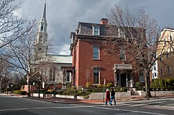
1:
319:Central Congregational Church
307:Rhode Island School of Design
118:Show map of the United States
267:in 1636 on the banks of the
21:United States historic place
1082:
985:
677:
593:(HABS) No. RI-163, "
583:(HABS) No. RI-406, "
199:NRHP reference
127:
71:
59:
55:
46:
37:
30:
26:
191:Architectural style
140:Providence, Rhode Island
93:Show map of Rhode Island
339:contributing properties
651:Keeper of the Register
524:U of Minnesota Press.
350:John Nicholas Brown II
250:. It was designated a
666:National Park Service
646:Contributing property
496:accompanying pictures
482:National Park Service
423:National Park Service
289:Stephen Hopkins House
167:41.82639°N 71.40333°W
484:. September 14, 1976
327:Providence Athenaeum
291:remain in the area.
225:Designated NHLD
1015:Rhode Island portal
372:Rhode Island portal
287:houses such as the
172:41.82639; -71.40333
163: /
346:Antoinette Downing
299:Moses Brown School
238:is located in the
1023:
1022:
981:
980:
926:Washington County
835:Providence County
656:Historic district
558:978-1-317-15832-5
531:978-1-4529-5540-7
425:. March 13, 2009.
285:American colonial
232:
231:
228:December 30, 1970
220:November 10, 1970
212:Significant dates
1073:
1013:
1003:
993:
992:
892:North Smithfield
887:North Providence
729:
683:
682:
625:
618:
611:
602:
563:
562:
542:
536:
535:
515:
509:
504:
498:
493:
491:
489:
474:
468:
463:
457:
456:
454:
452:
433:
427:
426:
409:
374:
369:
368:
367:
295:Brown University
277:Wickenden Street
269:Providence River
242:neighborhood of
202:
178:
177:
175:
174:
173:
168:
164:
161:
160:
159:
156:
119:
113:
112:
106:
94:
88:
87:
81:
64:
24:
1081:
1080:
1076:
1075:
1074:
1072:
1071:
1070:
1026:
1025:
1024:
1019:
977:
968:South Kingstown
958:North Kingstown
921:
862:East Providence
830:
789:
753:
720:
689:Lists by county
684:
680:
675:
634:
629:
572:
567:
566:
559:
544:
543:
539:
532:
517:
516:
512:
505:
501:
487:
485:
476:
475:
471:
464:
460:
450:
448:
447:on June 6, 2011
435:
434:
430:
411:
410:
406:
401:
378:
377:
370:
365:
363:
358:
335:
323:Old State House
261:
171:
169:
165:
162:
157:
154:
152:
150:
149:
130:
123:
122:
121:
120:
117:
116:
115:
114:
97:
96:
95:
92:
91:
90:
89:
67:
51:
42:
33:
22:
17:
12:
11:
5:
1079:
1077:
1069:
1068:
1063:
1058:
1053:
1048:
1043:
1038:
1028:
1027:
1021:
1020:
1018:
1017:
1007:
997:
986:
983:
982:
979:
978:
976:
975:
970:
965:
960:
955:
950:
945:
940:
935:
929:
927:
923:
922:
920:
919:
914:
909:
904:
899:
894:
889:
884:
879:
874:
869:
864:
859:
854:
849:
844:
838:
836:
832:
831:
829:
828:
823:
818:
813:
808:
806:Little Compton
803:
797:
795:
794:Newport County
791:
790:
788:
787:
782:
780:West Greenwich
777:
772:
770:East Greenwich
767:
761:
759:
755:
754:
752:
751:
746:
741:
735:
733:
732:Bristol County
726:
722:
721:
719:
718:
713:
708:
703:
698:
692:
690:
686:
685:
678:
676:
674:
673:
671:Property types
668:
663:
658:
653:
648:
642:
640:
636:
635:
630:
628:
627:
620:
613:
605:
599:
598:
588:
578:
571:
570:External links
568:
565:
564:
557:
537:
530:
510:
499:
469:
458:
428:
403:
402:
400:
397:
396:
395:
390:
385:
376:
375:
360:
359:
357:
354:
334:
331:
303:Wheeler School
265:Roger Williams
260:
257:
230:
229:
226:
222:
221:
218:
214:
213:
209:
208:
203:
196:
195:
192:
188:
187:
184:
180:
179:
147:
143:
142:
136:
132:
131:
128:
125:
124:
108:
107:
101:
100:
99:
98:
83:
82:
76:
75:
74:
73:
72:
69:
68:
66:Benefit Street
65:
57:
56:
53:
52:
47:
44:
43:
38:
35:
34:
31:
28:
27:
20:
15:
13:
10:
9:
6:
4:
3:
2:
1078:
1067:
1064:
1062:
1059:
1057:
1054:
1052:
1049:
1047:
1044:
1042:
1039:
1037:
1034:
1033:
1031:
1016:
1012:
1008:
1006:
1002:
998:
996:
988:
987:
984:
974:
971:
969:
966:
964:
961:
959:
956:
954:
951:
949:
946:
944:
941:
939:
936:
934:
931:
930:
928:
924:
918:
915:
913:
910:
908:
905:
903:
900:
898:
895:
893:
890:
888:
885:
883:
880:
878:
875:
873:
870:
868:
865:
863:
860:
858:
855:
853:
850:
848:
847:Central Falls
845:
843:
840:
839:
837:
833:
827:
824:
822:
819:
817:
814:
812:
809:
807:
804:
802:
799:
798:
796:
792:
786:
783:
781:
778:
776:
773:
771:
768:
766:
763:
762:
760:
756:
750:
747:
745:
742:
740:
737:
736:
734:
730:
727:
725:Lists by city
723:
717:
714:
712:
709:
707:
704:
702:
699:
697:
694:
693:
691:
687:
672:
669:
667:
664:
662:
659:
657:
654:
652:
649:
647:
644:
643:
641:
637:
633:
626:
621:
619:
614:
612:
607:
606:
603:
596:
592:
589:
586:
582:
579:
577:
574:
573:
569:
560:
554:
551:. Routledge.
550:
549:
541:
538:
533:
527:
523:
522:
514:
511:
508:
503:
500:
497:
483:
479:
473:
470:
467:
462:
459:
446:
442:
438:
432:
429:
424:
420:
419:
414:
408:
405:
398:
394:
391:
389:
386:
383:
380:
379:
373:
362:
355:
353:
351:
347:
342:
340:
332:
330:
328:
324:
320:
316:
312:
311:Thayer Street
308:
304:
300:
296:
292:
290:
286:
282:
278:
274:
270:
266:
258:
256:
253:
249:
245:
241:
237:
227:
223:
219:
217:Added to NRHP
215:
210:
207:
204:
197:
193:
189:
185:
181:
176:
148:
144:
141:
137:
133:
126:
105:
80:
70:
63:
58:
54:
50:
45:
41:
36:
29:
25:
19:
953:New Shoreham
948:Narragansett
842:Burrillville
785:West Warwick
547:
540:
520:
513:
502:
488:September 5,
486:. Retrieved
472:
461:
449:. Retrieved
445:the original
440:
431:
416:
407:
343:
336:
293:
262:
248:Rhode Island
240:College Hill
235:
233:
18:
1005:NRHP portal
933:Charlestown
758:Kent County
333:Designation
170: /
146:Coordinates
1030:Categories
917:Woonsocket
912:Smithfield
902:Providence
857:Cumberland
821:Portsmouth
811:Middletown
739:Barrington
716:Washington
711:Providence
399:References
305:, and the
244:Providence
158:71°24′12″W
155:41°49′35″N
943:Hopkinton
897:Pawtucket
872:Glocester
801:Jamestown
281:Victorian
183:Architect
995:Category
973:Westerly
963:Richmond
907:Scituate
877:Johnston
852:Cranston
826:Tiverton
765:Coventry
451:June 28,
356:See also
206:70000019
186:Multiple
135:Location
882:Lincoln
816:Newport
775:Warwick
744:Bristol
706:Newport
696:Bristol
259:History
938:Exeter
867:Foster
749:Warren
639:Topics
555:
528:
494:With
701:Kent
553:ISBN
526:ISBN
490:2023
453:2008
348:and
325:and
317:and
283:and
234:The
201:No.
1032::
480:.
439:.
421:.
415:.
352:.
301:,
297:,
246:,
624:e
617:t
610:v
561:.
534:.
492:.
455:.
Text is available under the Creative Commons Attribution-ShareAlike License. Additional terms may apply.