397:
405:
444:. The state highway intersects George Mason Drive, SR 120 (Glebe Road), and Walter Reed Drive in Westmont, which is a center for Arlington's immigrant community, with many stores, restaurants, and other businesses representing south Arlington's cultural diversity. East of Westmont, SR 244 has a partial cloverleaf interchange with SR 27 (Washington Boulevard) that provides access to both directions of I-395 (Henry G. Shirley Memorial Highway) at the western end of the Mixing Bowl interchange of the Pentagon road network. The state highway passes to the south of
513:
948:
37:
772:
753:
699:
1017:
was completed in 2001 when a 184 long bridge over Holmes Run was completed. Prior to 2007, the section from Powell to
Firehouse was built. In 2007 the Holmes Run Trail was extended to connect to the Columbia Pike Trail. In 2012, the gap between Holmes and Run and Powell Lane was closed. In June 2017, the trail section between Powell and Madison was widened and rebuilt at a new grade.
942:
885:
706:
855:
686:
628:
309:
294:
139:
102:
936:
879:
160:
56:
816:
680:
622:
125:
693:
674:
954:
891:
712:
165:
416:, two-lane street westbound that has access only to westbound SR 236. Two-way traffic on the highway begins at its intersection with SR 617 (Backlick Road), through which all other connections between SR 244 and SR 236 are made. SR 244 heads east out of the center of Annandale as a four-lane undivided highway that becomes
404:
1016:
Near Lake
Barcroft in Fairfax County, a 0.5 mile long trail called the Columbia Pike Trail runs along the south side of the pike. The trail runs from Firehouse Lane in Bailey's Crossroads to Mary Meindl Court In Lincolnia. The first section of the trail, from Lincolnia to just short of Powell Lane
547:
In 2002, Arlington County adopted the
Columbia Pike Initiative, a revitalization plan for the three-and-a-half mile corridor in Arlington. The plan called for development of a high-capacity transit system. The Columbia Pike Initiative was followed in 2003 by adoption of the Form Based Code, which
543:
Columbia Pike was replaced by the
Shirley Highway as the Virginia approach to the Long Bridge/14th Street Bridge. By 1944, SR 244 was truncated at the Pentagon; the piece curving away from the original alignment became a state highway in 1964. Until the 1990s, Columbia Pike accommodated rush hour
460:
reservation. Just to the east, the state highway has another partial cloverleaf interchange with SR 27 that provides access to southbound I-395. SR 244 reaches its eastern terminus at the eastern end of the interchange at the entrance to the
Pentagon South parking lot.
1104:
An Act to incorporate a company for making certain turnpike roads in the
District of Columbia, 2 U.S. Statutes at Large 570 (Apr. 20, 1810). Unfortunately, the date is erroneously given as 1808 in some texts, which has led to confusion. See, e.g., C.B. Rose, Jr.,
396:
1079:
551:
Recent efforts by the
Columbia Pike Revitalization Organization include the replacement of older traffic signals with newer and more aesthetic ones, and the addition of brick texture to crosswalks. County officials also teamed up with the
420:
at its intersection with SR 711 (Gallows Road). The state highway veers northeast at its junction with SR 613 (Lincolnia Road) and SR 712 (Old
Columbia Pike). SR 244 crosses Holmes Run as it curves around the southeastern end of
477:
to outlying destinations. One of these roads was to be built through a portion of the
District of Columbia that had previously been part of Virginia. This portion was then known as Alexandria County, D.C. (now
548:
guides development along
Columbia Pike. In 2004, the Columbia Pike Street Space Planning Task Force recommended future transit operate in mixed traffic and that the transitway be located in the curb lanes.
544:
traffic by reversing the direction of one lane using overhead signals. In October 2010, Virginia transferred responsibility for the eastern portion of Columbia Pike to Arlington County.
1390:
357:
1385:
560:
remodeled bus stops and doubled bus frequency along Columbia Pike. In 2006, the Arlington County and Fairfax County Board of Supervisors approved plans of bringing railed
1301:
553:
262:
441:
257:
793:
775:
756:
721:
653:
247:
1187:
568:
area. In 2016, Arlington County proposed a "premium transit network" using busses in mixed traffic (not dedicated lanes) in place of streetcars.
1350:
487:
272:
69:
445:
1375:
1357:
1345:
1237:
412:
SR 244 begins at an intersection with SR 236 (Little River Turnpike) in Annandale. The westernmost segment of the state highway is a
252:
1212:
803:
536:
453:
377:
132:
499:
426:
539:
and then, between 1934 and 1937, further west to its current terminus at SR 236 in Annandale. With the construction of the
1325:
528:
483:
457:
1121:
1380:
837:
479:
449:
385:
239:
220:
966:
962:
899:
725:
172:
858:
717:
632:
603:
532:
491:
381:
369:
345:
312:
297:
216:
142:
105:
1061:
958:
895:
524:
456:, SR 244 becomes a divided highway, passes through an S-curve, and briefly follows the southern edge of the
353:
267:
168:
1145:
1055:
823:
819:
470:
429:
with SR 7 (Leesburg Pike) at Bailey's Crossroads before crossing the Fairfax–Arlington county line.
373:
128:
742:
1041:
729:
565:
509:
in 1928 from the bridge west to Palmer's Hill in Barcroft as part of an experimental testing program.
827:
733:
474:
907:
779:
608:
502:
437:
365:
349:
146:
999:
974:
911:
842:
277:
498:
and was also known as the Washington Road, the Columbian Road, and the Arlington Turnpike. The
1292:
636:
564:
to Columbia Pike along an either a 5 or 6-mile (9.7 km) stretch from the Pentagon to the
657:
1310:
1166:
417:
413:
17:
970:
915:
1369:
1320:
433:
422:
333:
196:
109:
473:
chartered a turnpike Company to build three separate roads through the newly formed
978:
540:
512:
361:
176:
1084:
1188:"Premium Bus Service Planned for Columbia Pike, Dedicated Lanes to Be Studied"
556:
to increase mass transit service along the corridor. This new program called
903:
561:
557:
531:, it was renumbered State Route 244 and the numbering was extended first to
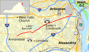
368:. SR 244 is a major southwest–northeast thoroughfare in northeastern
1315:
36:
506:
482:). The purpose of this road was to provide access westward from the new
337:
206:
1122:"Commonwealth Transportation Board Approves Pike Transfer to Arlington"
641:
Western terminus; access from westbound SR 244 to westbound SR 236 only
55:
1326:
Washington Post article about proposed street cars along Columbia Pike
1238:"Dedicated Lanes Unlikely for Columbia Pike 'Premium Transit Network'"
1335:
1300:
527:
near the Long Bridge west for around 1 mile (1.6 km). In the
403:
395:
1213:"Columbia Pike 'Premium Transit Network' Gets Cautious Approval"
618:
1330:
1154:
989:
1.000 mi = 1.609 km; 1.000 km = 0.621 mi
511:
494:. The new road was built on a pre-existing cow path as the
1155:
official website of the government of Arlington County, VA
728: / John Marr Drive / Chatelain Road (SR 2948) –
1056:
Fairfax County, City of Fairfax, and City of Falls Church
400:
View west at the east end of SR 244 at SR 27 in Arlington
344:, the state highway runs 8.25 miles (13.28 km) from
822:(Leesburg Pike) / to Seminary Road (SR 716) –
372:
and eastern Arlington County, connecting Annandale with
1288:
1283:
408:
View east along SR 244 from SR 7 in Bailey's Crossroads
1174:
1168:
Fairfax Co. Backs Trolley Proposal Along Columbia Pike
1074:
1072:
1036:
1034:
1032:
1030:
640:
432:SR 244 becomes an undivided highway shortly before
230:
212:
202:
192:
187:
154:
115:
96:
91:
83:
75:
62:
32:
984:Eastern terminus; partial cloverleaf interchange
1302:Template:Attached KML/Virginia State Route 244
554:Washington Metropolitan Area Transit Authority
1044:. Virginia Department of Transportation. 2010
8:
1391:Transportation in Arlington County, Virginia
1141:
1139:
442:Washington & Old Dominion Railroad Trail
1148:Board Endorses Streetcars for Columbia Pike
1386:Transportation in Fairfax County, Virginia
1340:
575:
286:
1321:Arlington's Urban Villages- Columbia Pike
1316:Columbia Pike Revitalization Organization
1305:
1356:
1343:
1157:, April 26, 2006. Accessed May 8, 2009.
1062:Arlington County and City of Alexandria
1026:
490:to the Little River Turnpike Road, now
1351:District 7 State Routes
1242:ARLnow.com - Arlington, Va. Local News
1217:ARLnow.com - Arlington, Va. Local News
1192:ARLnow.com - Arlington, Va. Local News
1124:. Arlington County. September 16, 2010
29:
27:State highway in northern Virginia, US
1108:Arlington County, Virginia: A History
933:
927:
876:
870:
852:
846:
813:
807:
791:
787:
769:
765:
750:
746:
670:
666:
662:east end of one-way westbound section
651:
645:
612:
469:Columbia Pike dates to 1810 when the
436:, where the highway also crosses the
7:
1177:, May 1, 2006. Accessed May 8, 2009.
635:west (Little River Turnpike) –
519:Columbia Pike was first numbered as
1336:Social History of Columbia Heights
1175:wtop.com: official website of WTOP
590:
25:
1311:Virginia Highways Project: VA 244
79:8.25 mi (13.28 km)
1331:Columbia Pike Transit Initiative
952:
946:
940:
934:
889:
883:
877:
853:
814:
770:
751:
710:
704:
697:
691:
684:
678:
672:
656:south) / Maple Place (SR 758) -
626:
620:
454:United States Air Force Memorial
307:
292:
163:
158:
137:
123:
100:
54:
35:
920:Partial cloverleaf interchange
832:Partial cloverleaf interchange
500:U.S. Department of Agriculture
427:partial cloverleaf interchange
1:
585:
496:Washington Graveled Turnpike
1262:"Portion of Trail Opened".
458:Arlington National Cemetery
388:neighborhood of Arlington.
1407:
1376:State highways in Virginia
1080:"Virginia State Route 244"
961:(Washington Boulevard) to
488:14th Street Bridge complex
480:Arlington County, Virginia
450:United States Marine Corps
448:, the headquarters of the
1349:
988:
983:
930:
924:
919:
873:
867:
863:
849:
841:
836:
831:
810:
802:
798:
789:
783:
767:
761:
748:
741:
737:
668:
661:
648:
615:
607:
602:
597:
594:
589:
584:
581:
578:
285:
235:
226:
183:
67:
53:
48:
995:
778:(Lincolnia Road) –
492:Virginia State Route 236
18:Columbia Pike (Virginia)
516:
409:
401:
515:
407:
399:
384:in the multicultural
336:in the U.S. state of
1306:KML is from Wikidata
759:(Sleepy Hollow Road)
475:District of Columbia
1264:The Washington Post
1042:"2010 Traffic Data"
1012:Columbia Pike Trail
804:Bailey's Crossroads
572:Major intersections
537:Bailey's Crossroads
440:and intersects the
438:Four Mile Run Trail
378:Bailey's Crossroads
133:Bailey's Crossroads
117:Major intersections
861:(South Glebe Road)
517:
486:that predated the
410:
402:
1381:Northern Virginia
1364:
1363:
1009:
1008:
1000:Incomplete access
392:Route description
323:
322:
319:
318:
63:Route information
16:(Redirected from
1398:
1341:
1296:
1268:
1267:
1259:
1253:
1252:
1250:
1249:
1234:
1228:
1227:
1225:
1224:
1209:
1203:
1202:
1200:
1199:
1184:
1178:
1164:
1158:
1143:
1134:
1133:
1131:
1129:
1118:
1112:
1102:
1096:
1095:
1093:
1092:
1076:
1067:
1052:
1050:
1049:
1038:
1002:
996:
957:
956:
955:
950:
949:
944:
943:
938:
937:
894:
893:
892:
887:
886:
881:
880:
857:
856:
818:
817:
774:
773:
755:
754:
715:
714:
713:
708:
707:
702:
701:
700:
695:
694:
689:
688:
687:
682:
681:
676:
675:
631:
630:
629:
624:
623:
592:
587:
576:
529:1933 renumbering
315:
311:
310:
300:
296:
295:
287:
167:
166:
162:
161:
141:
140:
127:
126:
118:
104:
103:
58:
39:
30:
21:
1406:
1405:
1401:
1400:
1399:
1397:
1396:
1395:
1366:
1365:
1353:
1307:
1304:
1299:
1298:
1297:
1281:
1277:
1272:
1271:
1266:. 21 June 2001.
1261:
1260:
1256:
1247:
1245:
1236:
1235:
1231:
1222:
1220:
1211:
1210:
1206:
1197:
1195:
1186:
1185:
1181:
1165:
1161:
1144:
1137:
1127:
1125:
1120:
1119:
1115:
1111:, p. 76 (1976).
1103:
1099:
1090:
1088:
1078:
1077:
1070:
1047:
1045:
1040:
1039:
1028:
1023:
1014:
1005:
998:
994:
990:
967:Memorial Bridge
953:
951:
947:
945:
941:
939:
935:
890:
888:
884:
882:
878:
854:
815:
792:Braddock Road (
771:
752:
711:
709:
705:
703:
698:
696:
692:
690:
685:
683:
679:
677:
673:
671:
652:Backlick Road (
627:
625:
621:
619:
574:
521:State Route 720
467:
425:. SR 244 has a
394:
332:) is a primary
326:State Route 244
308:
306:
293:
291:
240:Virginia Routes
164:
159:
138:
124:
116:
101:
92:Major junctions
44:
43:
42:State Route 244
40:
28:
23:
22:
15:
12:
11:
5:
1404:
1402:
1394:
1393:
1388:
1383:
1378:
1368:
1367:
1362:
1361:
1355:
1348:
1339:
1338:
1333:
1328:
1323:
1318:
1313:
1280:
1279:
1278:
1276:
1275:External links
1273:
1270:
1269:
1254:
1229:
1204:
1179:
1159:
1146:News Release:
1135:
1113:
1097:
1068:
1066:
1065:
1059:
1025:
1024:
1022:
1019:
1013:
1010:
1007:
1006:
1004:
1003:
991:
986:
985:
982:
932:
929:
926:
922:
921:
918:
875:
872:
869:
865:
864:
862:
851:
848:
845:
840:
834:
833:
830:
812:
809:
806:
800:
799:
797:
790:
788:
785:
784:
782:
768:
766:
763:
762:
760:
749:
747:
745:
739:
738:
736:
669:
667:
664:
663:
660:
650:
647:
643:
642:
639:
617:
614:
611:
606:
600:
599:
596:
593:
588:
583:
580:
573:
570:
505:the road with
466:
463:
446:Henderson Hall
393:
390:
370:Fairfax County
358:Interstate 395
321:
320:
317:
316:
303:
301:
283:
282:
281:
280:
275:
270:
265:
260:
255:
250:
244:
243:
233:
232:
231:Highway system
228:
227:
224:
223:
214:
210:
209:
204:
200:
199:
194:
190:
189:
185:
184:
181:
180:
156:
152:
151:
150:
149:
135:
119:
113:
112:
98:
94:
93:
89:
88:
85:
81:
80:
77:
73:
72:
68:Maintained by
65:
64:
60:
59:
51:
50:
46:
45:
41:
34:
33:
26:
24:
14:
13:
10:
9:
6:
4:
3:
2:
1403:
1392:
1389:
1387:
1384:
1382:
1379:
1377:
1374:
1373:
1371:
1359:
1352:
1347:
1342:
1337:
1334:
1332:
1329:
1327:
1324:
1322:
1319:
1317:
1314:
1312:
1309:
1308:
1303:
1294:
1290:
1286:
1285:
1274:
1265:
1258:
1255:
1243:
1239:
1233:
1230:
1218:
1214:
1208:
1205:
1193:
1189:
1183:
1180:
1176:
1173:
1170:
1169:
1163:
1160:
1156:
1153:
1150:
1149:
1142:
1140:
1136:
1123:
1117:
1114:
1110:
1109:
1101:
1098:
1087:
1086:
1081:
1075:
1073:
1069:
1063:
1060:
1057:
1054:
1053:
1043:
1037:
1035:
1033:
1031:
1027:
1020:
1018:
1011:
1001:
993:
992:
987:
981:South Parking
980:
976:
972:
968:
965:south –
964:
960:
923:
917:
913:
909:
905:
901:
897:
866:
860:
844:
839:
835:
829:
825:
821:
805:
801:
795:
786:
781:
777:
764:
758:
744:
740:
735:
731:
727:
723:
719:
665:
659:
655:
644:
638:
634:
610:
605:
601:
577:
571:
569:
567:
563:
559:
555:
549:
545:
542:
538:
534:
533:State Route 7
530:
526:
523:in 1930 from
522:
514:
510:
508:
504:
501:
497:
493:
489:
485:
481:
476:
472:
471:U.S. Congress
464:
462:
459:
455:
451:
447:
443:
439:
435:
434:Four Mile Run
430:
428:
424:
423:Lake Barcroft
419:
415:
406:
398:
391:
389:
387:
383:
379:
375:
371:
367:
363:
359:
355:
351:
347:
343:
342:Columbia Pike
339:
335:
334:state highway
331:
327:
314:
304:
302:
299:
289:
288:
284:
279:
276:
274:
271:
269:
266:
264:
261:
259:
256:
254:
251:
249:
246:
245:
242:
241:
237:
236:
234:
229:
225:
222:
218:
215:
211:
208:
205:
201:
198:
197:United States
195:
191:
186:
182:
178:
174:
170:
157:
155:East end
153:
148:
144:
136:
134:
130:
122:
121:
120:
114:
111:
107:
99:
97:West end
95:
90:
86:
82:
78:
74:
71:
66:
61:
57:
52:
49:Columbia Pike
47:
38:
31:
19:
1282:
1263:
1257:
1246:. Retrieved
1244:. 2017-06-28
1241:
1232:
1221:. Retrieved
1219:. 2017-07-12
1216:
1207:
1196:. Retrieved
1194:. 2016-01-27
1191:
1182:
1171:
1167:
1162:
1151:
1147:
1126:. Retrieved
1116:
1107:
1106:
1100:
1089:. Retrieved
1083:
1046:. Retrieved
1015:
997:
824:Falls Church
720:east /
658:Falls Church
595:Destinations
550:
546:
525:U.S. Route 1
520:
518:
495:
468:
431:
411:
362:The Pentagon
341:
329:
325:
324:
238:
179:in Arlington
177:The Pentagon
87:1933–present
1360: >
1358:SR 721
1346:SR 719
1128:December 4,
1085:Google Maps
859:SR 120
776:SR 613
757:SR 613
730:Springfield
722:SR 617
718:SR 236
633:SR 236
484:Long Bridge
360:(I-395) at
340:. Known as
313:SR 245
298:SR 243
143:SR 120
106:SR 236
1370:Categories
1354:1928–1933
1344:<
1248:2017-08-06
1223:2017-08-06
1198:2017-08-06
1091:2011-12-14
1048:2011-12-14
1021:References
971:Washington
959:SR 27
916:Washington
896:SR 27
828:Alexandria
734:Alexandria
562:streetcars
248:Interstate
169:SR 27
908:Clarendon
904:Fort Myer
838:Arlington
820:SR 7
780:Lincolnia
743:Belvedere
609:Annandale
558:Pike Ride
452:. At the
366:Arlington
350:Annandale
278:HOT lanes
263:Secondary
221:Arlington
147:Arlington
129:SR 7
110:Annandale
1284:KML file
979:Pentagon
975:Richmond
912:Richmond
902: –
843:Westmont
724: /
582:Location
541:Pentagon
507:concrete
386:Westmont
352:east to
338:Virginia
213:Counties
207:Virginia
188:Location
171: /
1082:(Map).
925:
868:
637:Fairfax
604:Fairfax
566:Skyline
465:History
418:divided
414:one-way
273:History
258:Primary
217:Fairfax
193:Country
84:Existed
794:SR 620
654:SR 617
579:County
382:SR 120
346:SR 236
330:SR 244
268:Byways
76:Length
1064:(PDF)
1058:(PDF)
963:I-395
931:13.28
900:I-395
874:11.72
850:10.06
726:I-495
598:Notes
503:paved
354:SR 27
203:State
173:I-395
1293:help
1289:edit
1130:2010
928:8.25
871:7.28
847:6.25
811:6.53
808:4.06
649:0.16
646:0.10
616:0.00
613:0.00
380:and
374:SR 7
356:and
70:VDOT
898:to
716:To
535:at
376:at
364:in
348:in
175:at
145:in
131:at
108:in
1372::
1291:•
1240:.
1215:.
1190:.
1172:in
1152:in
1138:^
1071:^
1029:^
977:,
973:,
969:,
914:,
910:,
906:,
826:,
732:,
591:km
586:mi
305:→
290:←
253:US
219:,
1295:)
1287:(
1251:.
1226:.
1201:.
1132:.
1094:.
1051:.
796:)
328:(
20:)
Text is available under the Creative Commons Attribution-ShareAlike License. Additional terms may apply.