124:
25:
242:
the falls flow over, the falls themselves were not damaged, but the mudflows still left their mark. A canyon up to 10 feet (3.0 m) deep was carved by the mudflows just below the falls and all plant life lining the creek below the falls was washed away and replaced by dead vegetation. Also, the
229:
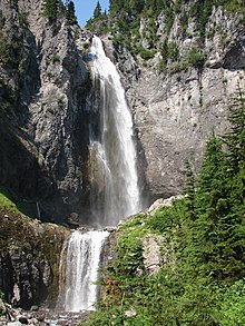
in one lofty plunge. The height of the plunge is actually 320 feet (98 m). The falls are more than that though, as there are two obvious smaller tiers below the main drop as well as one just visible above the main drop. The bottom two drops are 40 and 20 feet (6.1 m) high while the
251:
The floods of 2003 and 2006 actually helped the falls a lot because it removed most of the debris that previously lined the creek below the falls. Once again, due to the strong bedrock the falls flow over, the falls were not altered much.
230:
height of the upper drop is not known. In any case, assuming the upper drop is at least 20 feet (6.1 m) high, the falls are likely around 400 feet (120 m) high.
518:
305:
35:
523:
513:
298:
460:
385:
291:
50:
93:
65:
123:
315:
138:
474:
528:
72:
283:
450:
405:
210:
142:
360:
79:
340:
61:
400:
375:
370:
355:
425:
395:
420:
330:
440:
365:
335:
319:
445:
380:
455:
345:
206:
190:
86:
226:
507:
214:
146:
435:
415:
390:
430:
410:
24:
489:
476:
202:
153:
239:
269:
243:
pool at the base of the main drop was filled in by rock and debris.
225:
At first glance the falls drop about 300 feet (91 m) out of a
42:
287:
18:
46:
186:
178:
170:
162:
152:
134:
116:
213:. The falls are thought to be the best in the
16:Waterfall in Washington (state), United States
299:
8:
51:introducing citations to additional sources
306:
292:
284:
122:
113:
41:Relevant discussion may be found on the
519:Waterfalls of Pierce County, Washington
261:
7:
14:
524:Waterfalls of Washington (state)
34:relies largely or entirely on a
23:
185:
177:
169:
161:
1:
270:"Northwest Waterfall Survey"
514:Mount Rainier National Park
316:Mount Rainier National Park
274:www.waterfallsnorthwest.com
139:Mount Rainier National Park
545:
326:
211:Pierce County, Washington
143:Pierce County, Washington
130:
121:
247:Floods of 2003 and 2006
490:46.79583°N 121.78000°W
314:Waterfalls in or near
166:380 feet (120 m)
495:46.79583; -121.78000
426:South Mowich Glacier
396:North Mowich Glacier
182:30 feet (9.1 m)
47:improve this article
486: /
451:Upper Stevens Creek
234:Debris Flow of 2001
238:Due to the strong
529:Plunge waterfalls
469:
468:
196:
195:
112:
111:
97:
536:
501:
500:
498:
497:
496:
491:
487:
484:
483:
482:
479:
308:
301:
294:
285:
278:
277:
266:
126:
114:
107:
104:
98:
96:
55:
27:
19:
544:
543:
539:
538:
537:
535:
534:
533:
504:
503:
494:
492:
488:
485:
480:
477:
475:
473:
472:
470:
465:
322:
312:
282:
281:
268:
267:
263:
258:
249:
236:
223:
207:Van Trump Creek
191:Van Trump Creek
171:Number of drops
108:
102:
99:
56:
54:
40:
28:
17:
12:
11:
5:
542:
540:
532:
531:
526:
521:
516:
506:
505:
467:
466:
464:
463:
461:Wilson Glacier
458:
453:
448:
443:
438:
433:
428:
423:
418:
413:
408:
406:Paradise River
403:
398:
393:
388:
383:
378:
373:
368:
363:
358:
353:
348:
343:
338:
333:
327:
324:
323:
313:
311:
310:
303:
296:
288:
280:
279:
260:
259:
257:
254:
248:
245:
235:
232:
227:hanging valley
222:
219:
194:
193:
188:
184:
183:
180:
176:
175:
172:
168:
167:
164:
160:
159:
156:
150:
149:
136:
132:
131:
128:
127:
119:
118:
110:
109:
45:. Please help
31:
29:
22:
15:
13:
10:
9:
6:
4:
3:
2:
541:
530:
527:
525:
522:
520:
517:
515:
512:
511:
509:
502:
499:
462:
459:
457:
454:
452:
449:
447:
444:
442:
439:
437:
434:
432:
429:
427:
424:
422:
419:
417:
414:
412:
409:
407:
404:
402:
399:
397:
394:
392:
389:
387:
386:Little Mashel
384:
382:
379:
377:
374:
372:
369:
367:
364:
362:
359:
357:
354:
352:
349:
347:
344:
342:
341:Chinook Creek
339:
337:
334:
332:
329:
328:
325:
321:
317:
309:
304:
302:
297:
295:
290:
289:
286:
275:
271:
265:
262:
255:
253:
246:
244:
241:
233:
231:
228:
220:
218:
216:
215:Mount Rainier
212:
208:
204:
200:
192:
189:
181:
173:
165:
157:
155:
151:
148:
147:United States
144:
140:
137:
133:
129:
125:
120:
115:
106:
95:
92:
88:
85:
81:
78:
74:
71:
67:
64: –
63:
62:"Comet Falls"
59:
58:Find sources:
52:
48:
44:
38:
37:
36:single source
32:This article
30:
26:
21:
20:
471:
350:
273:
264:
250:
237:
224:
198:
197:
163:Total height
103:January 2023
100:
90:
83:
76:
69:
57:
33:
493: /
481:121°46′48″W
446:Upper Comet
401:Ohanapecosh
381:Kautz Creek
376:Golden Gate
371:Fish Ladder
205:located on
199:Comet Falls
187:Watercourse
179:Total width
117:Comet Falls
508:Categories
478:46°47′45″N
356:Deer Creek
320:Washington
256:References
201:is a tall
73:newspapers
456:Van Trump
346:Christine
203:waterfall
43:talk page
421:Snoquera
331:Bloucher
217:region.
135:Location
441:Thunder
366:Faraway
240:bedrock
221:Stature
87:scholar
436:Sydney
416:Silver
391:Narada
336:Carter
158:Tiered
89:
82:
75:
68:
60:
431:Spray
411:Pearl
361:Fairy
351:Comet
94:JSTOR
80:books
154:Type
66:news
318:of
209:in
49:by
510::
272:.
145:,
141:,
307:e
300:t
293:v
276:.
174:4
105:)
101:(
91:·
84:·
77:·
70:·
53:.
39:.
Text is available under the Creative Commons Attribution-ShareAlike License. Additional terms may apply.