42:
56:
607:
396:
The
Partnership meets twice a year to identify the prioritisation of action and the implementation of the Plan. The Partnership also has an advisory role, providing advice to Cornwall Council and other organisations on matters such as planning and project development. The Partnership is supported by
167:
places a duty on all relevant authorities when discharging any function affecting land within an AONB to have regard to the purpose of conserving and enhancing natural beauty. Section 89 places a statutory duty on Local
Planning Authorities with an AONB within their administrative area to produce a
397:
a team of officers—the
Cornwall AONB Unit who exist to administer the Partnership, undertake delivery, access resources, influence, enable and support Partner organisations in the delivery of the Management Plan.
964:
596:
400:
The first
Cornwall AONB Management Plan was adopted by the members of the Cornwall AONB Partnership in July 2004. The latest Cornwall AONB Management Plan, 2022-27, was adopted by
152:
361:
974:
552:
664:
784:
712:
641:
297:(which is partly in Cornwall and partly in Devon—the east bank of the river Tamar forms the boundary between Cornwall/Kernow and Devon), and the
164:
340:
82:
979:
877:
561:
160:
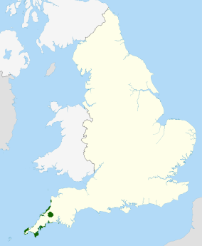
151:, England, United Kingdom; that is, about 27% of the total area of the county. It comprises 12 separate areas, designated under the
722:
591:
379:
839:
737:
498:
969:
834:
586:
545:
459:
176:
The areas were designated in 1959, except for the Camel estuary which was added in 1981. The list of designated areas is:
912:
804:
717:
478:
931:
799:
538:
892:
421:
390:
943:
335:
324:
984:
854:
753:
155:
for special landscape protection. Of the areas, eleven cover stretches of coastline; the twelfth is
163:(AONB): all AONBs have been rebranded as National Landscapes since November 2023. Section 85 of the
746:
41:
824:
771:
732:
697:
689:
656:
633:
623:
263:
223:
902:
819:
760:
669:
401:
356:
348:
319:
55:
907:
809:
779:
573:
482:
463:
371:
298:
267:
259:
917:
829:
702:
674:
646:
581:
366:
958:
872:
862:
615:
274:
252:
209:
200:
195:
191:
46:
814:
679:
516:
502:
205:
456:
530:
606:
294:
185:
156:
937:
882:
844:
727:
244:
181:
97:
84:
27:
Designated coastal areas and a moorland in southwesternmost county of
England
17:
867:
794:
707:
345:
ERCCIS (Environmental
Records Centre for Cornwall & the Isles of Scilly)
284:
232:
213:
475:
248:
148:
69:
565:
238:
228:
217:
126:
309:
The
Cornwall AONB is managed by a Partnership of 21 organisations
301:, which is administered for most purposes separately to Cornwall.
439:
278:
534:
404:
and the members of the
Cornwall AONB Partnership in May 2022.
147:) covers 958 square kilometres (370 sq mi) in
376:
Rural
Cornwall & Isles of Scilly Partnership (RCP)
153:
891:
853:
770:
688:
655:
632:
614:
572:
121:
113:
76:
65:
34:
521:The Cornwall Area of Outstanding Natural Beauty
444:The Cornwall Area of Outstanding Natural Beauty
965:Areas of Outstanding Natural Beauty in England
159:. The areas are together treated as a single
546:
493:
491:
422:"Cornwall Area of Outstanding Natural Beauty"
8:
353:Farming & Wildlife Advisory Group (FWAG)
332:Cornwall Sustainable Tourism Project (CoaST)
145:Cornwall Area of Outstanding Natural Beauty
553:
539:
531:
31:
785:Cranborne Chase and West Wiltshire Downs
713:Cranborne Chase and West Wiltshire Downs
413:
597:Suffolk & Essex Coast & Heaths
316:Cornwall Association of Local Councils
293:There are separate AONBs covering the
165:Countryside and Rights of Way Act 2000
341:Country Land and Business Association
7:
64:
975:Protected areas established in 1959
161:Area of Outstanding Natural Beauty
25:
605:
380:University of Exeter in Cornwall
329:Cornwall Rural Community Charity
54:
40:
112:
1:
440:"Cornwall National Landscape"
485:. Accessed 21 December 2015
980:Protected areas of Cornwall
499:"Cornwall AONB Partnership"
141:Cornwall National Landscape
1001:
313:Cornwall Agri-food Council
932:South Downs National Park
926:
603:
466:. Accessed 20 April 2012
60:Location of Cornwall AONB
53:
39:
938:New Forest National Park
462:August 29, 2013, at the
391:Westcountry Rivers Trust
168:5-year management plan.
336:Cornwall Wildlife Trust
325:Cornwall Heritage Trust
665:Arnside and Silverdale
476:Cornwall AONB: Explore
362:National Farmers Union
970:Geography of Cornwall
754:South Hampshire Coast
273:South Coast—Eastern (
258:South Coast—Central (
243:South Coast—Western (
642:Northumberland Coast
562:National Landscapes
505:on 11 October 2012.
426:protectedplanet.net
129:.cornwall-landscape
94: /
825:North Wessex Downs
733:North Wessex Downs
698:Chichester Harbour
624:Lincolnshire Wolds
481:2015-12-20 at the
387:Volunteer Cornwall
952:
951:
903:Forest of Bowland
820:North Devon Coast
670:Forest of Bowland
517:"Management Plan"
137:
136:
16:(Redirected from
992:
878:Shropshire Hills
609:
555:
548:
541:
532:
525:
524:
513:
507:
506:
501:. Archived from
495:
486:
473:
467:
454:
448:
447:
436:
430:
429:
418:
402:Cornwall Council
357:King Harry Ferry
349:Historic England
320:Cornwall Council
133:
130:
128:
109:
108:
106:
105:
104:
99:
98:50.509°N 4.597°W
95:
92:
91:
90:
87:
58:
44:
32:
21:
1000:
999:
995:
994:
993:
991:
990:
989:
955:
954:
953:
948:
922:
908:Howardian Hills
894:
887:
849:
810:Isles of Scilly
780:Blackdown Hills
766:
684:
651:
628:
610:
601:
574:East of England
568:
559:
529:
528:
515:
514:
510:
497:
496:
489:
483:Wayback Machine
474:
470:
464:Wayback Machine
455:
451:
438:
437:
433:
420:
419:
415:
410:
372:Natural England
307:
299:Isles of Scilly
174:
125:
102:
100:
96:
93:
88:
85:
83:
81:
80:
61:
49:
28:
23:
22:
15:
12:
11:
5:
998:
996:
988:
987:
982:
977:
972:
967:
957:
956:
950:
949:
947:
946:
940:
934:
927:
924:
923:
921:
920:
918:North Pennines
915:
910:
905:
899:
897:
889:
888:
886:
885:
880:
875:
870:
865:
859:
857:
851:
850:
848:
847:
842:
837:
832:
830:Quantock Hills
827:
822:
817:
812:
807:
802:
797:
792:
787:
782:
776:
774:
768:
767:
765:
764:
757:
750:
747:East Hampshire
741:
740:
735:
730:
725:
720:
715:
710:
705:
700:
694:
692:
686:
685:
683:
682:
677:
675:North Pennines
672:
667:
661:
659:
653:
652:
650:
649:
647:North Pennines
644:
638:
636:
630:
629:
627:
626:
620:
618:
612:
611:
604:
602:
600:
599:
594:
589:
584:
578:
576:
570:
569:
560:
558:
557:
550:
543:
535:
527:
526:
508:
487:
468:
449:
431:
412:
411:
409:
406:
394:
393:
388:
385:
382:
377:
374:
369:
367:National Trust
364:
359:
354:
351:
346:
343:
338:
333:
330:
327:
322:
317:
314:
306:
303:
291:
290:
287:
282:
271:
256:
241:
235:
226:
221:
203:
198:
189:
173:
170:
143:(formerly the
135:
134:
123:
119:
118:
115:
111:
110:
103:50.509; -4.597
78:
74:
73:
67:
63:
62:
59:
51:
50:
45:
37:
36:
26:
24:
14:
13:
10:
9:
6:
4:
3:
2:
997:
986:
985:Cornish coast
983:
981:
978:
976:
973:
971:
968:
966:
963:
962:
960:
945:
941:
939:
935:
933:
929:
928:
925:
919:
916:
914:
911:
909:
906:
904:
901:
900:
898:
896:
893:Yorkshire and
890:
884:
881:
879:
876:
874:
873:Malvern Hills
871:
869:
866:
864:
863:Cannock Chase
861:
860:
858:
856:
855:West Midlands
852:
846:
843:
841:
838:
836:
833:
831:
828:
826:
823:
821:
818:
816:
813:
811:
808:
806:
803:
801:
798:
796:
793:
791:
788:
786:
783:
781:
778:
777:
775:
773:
769:
763:
762:
758:
756:
755:
751:
749:
748:
743:
742:
739:
736:
734:
731:
729:
726:
724:
723:Isle of Wight
721:
719:
716:
714:
711:
709:
706:
704:
701:
699:
696:
695:
693:
691:
687:
681:
678:
676:
673:
671:
668:
666:
663:
662:
660:
658:
654:
648:
645:
643:
640:
639:
637:
635:
631:
625:
622:
621:
619:
617:
616:East Midlands
613:
608:
598:
595:
593:
592:Norfolk Coast
590:
588:
585:
583:
580:
579:
577:
575:
571:
567:
563:
556:
551:
549:
544:
542:
537:
536:
533:
522:
518:
512:
509:
504:
500:
494:
492:
488:
484:
480:
477:
472:
469:
465:
461:
458:
457:Cornwall AONB
453:
450:
445:
441:
435:
432:
427:
423:
417:
414:
407:
405:
403:
398:
392:
389:
386:
384:VisitCornwall
383:
381:
378:
375:
373:
370:
368:
365:
363:
360:
358:
355:
352:
350:
347:
344:
342:
339:
337:
334:
331:
328:
326:
323:
321:
318:
315:
312:
311:
310:
304:
302:
300:
296:
288:
286:
283:
280:
276:
272:
269:
265:
261:
257:
254:
253:Helford River
250:
246:
242:
240:
236:
234:
230:
227:
225:
222:
219:
215:
211:
210:Stepper Point
207:
204:
202:
201:Camel Estuary
199:
197:
193:
192:Pentire Point
190:
187:
183:
179:
178:
177:
171:
169:
166:
162:
158:
154:
150:
146:
142:
132:
124:
120:
116:
107:
79:
75:
71:
68:
57:
52:
48:
47:Cape Cornwall
43:
38:
33:
30:
19:
18:Cornwall AONB
936:Now part of
930:Now part of
840:Tamar Valley
815:Mendip Hills
789:
761:Sussex Downs
759:
752:
745:
738:Surrey Hills
680:Solway Coast
520:
511:
503:the original
471:
452:
443:
434:
425:
416:
399:
395:
308:
295:Tamar Valley
292:
264:the Roseland
206:Trevose Head
175:
144:
140:
138:
29:
835:South Devon
587:Dedham Vale
289:Bodmin Moor
186:Kilkhampton
172:Designation
157:Bodmin Moor
114:Established
101: /
77:Coordinates
959:Categories
942:Partly in
913:Nidderdale
895:the Humber
883:Wye Valley
845:Wye Valley
805:East Devon
772:South West
728:Kent Downs
718:High Weald
690:South East
657:North West
634:North East
408:References
305:Management
182:Morwenstow
180:Hartland (
86:50°30′32″N
868:Cotswolds
795:Cotswolds
708:Cotswolds
703:Chilterns
582:Chilterns
285:Rame Head
275:Par Sands
268:Porthpean
233:Portreath
214:Bedruthan
196:Widemouth
89:4°35′49″W
72:, England
790:Cornwall
744:Former:
479:Archived
460:Archived
249:Marazion
224:St Agnes
149:Cornwall
70:Cornwall
66:Location
35:Cornwall
566:England
239:Penwith
229:Godrevy
218:Padstow
122:Website
800:Dorset
245:Lizard
944:Wales
260:Mylor
237:West
279:Looe
262:and
247:and
184:and
139:The
131:.org
117:1959
564:in
277:to
266:to
251:to
231:to
216:to
208:to
194:to
127:www
961::
519:.
490:^
442:.
424:.
554:e
547:t
540:v
523:.
446:.
428:.
281:)
270:)
255:)
220:)
212:(
188:)
20:)
Text is available under the Creative Commons Attribution-ShareAlike License. Additional terms may apply.