33:
549:
656:
603:
319:
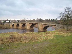
The bridge was the great asset of the town. Described in 1306 as the only bridge between
Newcastle and Carlisle, it was maintained also as a link between England and Scotland. In 1674 it was replaced by the seven-arched bridge we see today. So well did the builder of this bridge execute his contract that his was the only one on the Tyne to withstand the
318:
The bridge at
Corbridge was built in 1235. In 1298 royal officers went to Corbridge to purchase horseshoes and nails, and the tariff imposed to raise money for upkeep of the medieval bridge included tolls on nails of different kinds, horseshoes, cartwheel-sheaths, griddles, iron cauldrons and vats.
100:
742:
693:
727:
737:
640:
686:
50:
569:
88:
717:
679:
633:
712:
352:
467:
413:
347:
722:
626:
500:
565:
82:
43:
540:
32:
582:
492:
553:
548:
320:
732:
459:
496:
463:
409:
212:
427:
343:
307:
655:
419:
663:
610:
576:
303:
299:
273:
216:
153:
133:
123:
706:
534:
291:
143:
323:. In 1881 it was widened by 3 ft (1 m) but its appearance was not spoilt.
374:
524:
455:
265:
113:
65:
52:
602:
431:
423:
269:
295:
284:
277:
488:
288:
196:
302:, 3 miles (5 km) downstream of Corbridge. It is listed as a
207:
662:
667:
614:
609:
This article about a bridge in the United
Kingdom is a
250:
235:
227:
222:
202:
191:
180:
172:
164:
159:
149:
139:
129:
119:
109:
95:
81:
42:
23:
287:over the River Tyne, but since the opening of the
406:Hexham and Corbridge: A Short History and Guide
687:
634:
8:
743:Northumberland building and structure stubs
450:Fraser, Constance; Emsley, Kenneth (1989).
348:"Corbridge Bridge (Grade I) (1044808)"
728:Grade I listed buildings in Northumberland
694:
680:
641:
627:
547:
517:
264:is a 17th-century stone bridge across the
20:
445:
443:
441:
399:
397:
395:
738:United Kingdom bridge (structure) stubs
332:
338:
336:
7:
652:
650:
599:
597:
353:National Heritage List for England
14:
654:
601:
31:
408:. Thropton: Butler Publishing.
203:
181:
1:
298:) the A68 now crosses by the
283:The bridge used to carry the
666:. You can help Knowledge by
613:. You can help Knowledge by
718:Crossings of the River Tyne
759:
649:
596:
485:Portrait of Northumberland
713:Bridges in Northumberland
255:
30:
176:480 ft (146 m)
18:Bridge in Northumberland
723:Grade I listed bridges
529:Next bridge downstream
483:Ridley, Nancy (1966).
404:Frank Graham (1992).
521:Next bridge upstream
542: A6079
460:Phillimore & Co
379:Bridges on the Tyne
321:Great Flood of 1771
102: B6321
62: /
462:. pp. 78–79.
375:"Corbridge Bridge"
66:54.9722°N 2.0188°W
675:
674:
622:
621:
592:
591:
588:
584: A68
573:
559:
259:
258:
213:Single-track road
83:OS grid reference
750:
696:
689:
682:
658:
651:
643:
636:
629:
605:
598:
587:
585:
580:
572:
564:
562:Corbridge Bridge
558:
556:
555: 72
551:
545:
543:
538:
518:
507:
506:
480:
474:
473:
447:
436:
435:
401:
390:
389:
387:
385:
371:
365:
364:
362:
360:
344:Historic England
340:
308:Historic England
262:Corbridge Bridge
246:
244:
228:Construction end
205:
183:
105:
103:
91:
77:
76:
74:
73:
72:
71:54.9722; -2.0188
67:
63:
60:
59:
58:
55:
37:Corbridge Bridge
35:
25:Corbridge Bridge
21:
758:
757:
753:
752:
751:
749:
748:
747:
703:
702:
701:
700:
648:
647:
594:
583:
581:
579:
568:
563:
554:
552:
541:
539:
537:
516:
511:
510:
503:
495:. p. 183.
482:
481:
477:
470:
449:
448:
439:
416:
403:
402:
393:
383:
381:
373:
372:
368:
358:
356:
342:
341:
334:
329:
316:
242:
240:
160:Characteristics
130:Heritage status
101:
99:
87:
70:
68:
64:
61:
56:
53:
51:
49:
48:
38:
26:
19:
12:
11:
5:
756:
754:
746:
745:
740:
735:
730:
725:
720:
715:
705:
704:
699:
698:
691:
684:
676:
673:
672:
659:
646:
645:
638:
631:
623:
620:
619:
606:
590:
589:
577:Styford Bridge
574:
566:Grid reference
560:
531:
530:
527:
522:
515:
514:External links
512:
509:
508:
501:
475:
468:
437:
414:
391:
366:
331:
330:
328:
325:
315:
312:
304:Grade I listed
300:Styford Bridge
274:Northumberland
257:
256:
253:
252:
248:
247:
237:
233:
232:
229:
225:
224:
220:
219:
217:traffic lights
215:controlled by
210:
200:
199:
193:
189:
188:
185:
178:
177:
174:
170:
169:
166:
162:
161:
157:
156:
154:Styford Bridge
151:
147:
146:
141:
137:
136:
134:Grade I listed
131:
127:
126:
124:Northumberland
121:
117:
116:
111:
107:
106:
97:
93:
92:
85:
79:
78:
46:
40:
39:
36:
28:
27:
24:
17:
13:
10:
9:
6:
4:
3:
2:
755:
744:
741:
739:
736:
734:
731:
729:
726:
724:
721:
719:
716:
714:
711:
710:
708:
697:
692:
690:
685:
683:
678:
677:
671:
669:
665:
660:
657:
653:
644:
639:
637:
632:
630:
625:
624:
618:
616:
612:
607:
604:
600:
595:
586:
578:
575:
571:
567:
561:
557:
550:
544:
536:
535:Hexham Bridge
533:
532:
528:
526:
523:
520:
519:
513:
504:
498:
494:
490:
486:
479:
476:
471:
469:0-85033-723-2
465:
461:
457:
453:
446:
444:
442:
438:
433:
429:
425:
421:
417:
415:0-946928-19-3
411:
407:
400:
398:
396:
392:
380:
376:
370:
367:
355:
354:
349:
345:
339:
337:
333:
326:
324:
322:
313:
311:
309:
305:
301:
297:
293:
290:
286:
281:
279:
275:
271:
267:
263:
254:
249:
238:
234:
230:
226:
221:
218:
214:
211:
209:
201:
198:
194:
190:
186:
179:
175:
171:
167:
163:
158:
155:
152:
148:
145:
144:Hexham Bridge
142:
138:
135:
132:
128:
125:
122:
118:
115:
112:
108:
104:
98:
94:
90:
86:
84:
80:
75:
47:
45:
41:
34:
29:
22:
16:
668:expanding it
661:
615:expanding it
608:
593:
484:
478:
451:
405:
382:. Retrieved
378:
369:
357:. Retrieved
351:
317:
306:building by
282:
261:
260:
173:Total length
15:
493:Robert Hale
452:Northumbria
150:Followed by
140:Preceded by
69: /
44:Coordinates
707:Categories
525:River Tyne
502:0709117191
456:Chichester
432:Q105036820
327:References
266:River Tyne
192:Load limit
114:River Tyne
54:54°58′20″N
733:Corbridge
424:11572832M
270:Corbridge
57:2°01′08″W
570:NY988641
428:Wikidata
285:A68 road
251:Location
184:of spans
165:Material
89:NY988641
359:16 June
314:History
278:England
241: (
223:History
110:Crosses
96:Carries
499:
489:London
466:
430:
422:
412:
384:30 May
292:bypass
289:Hexham
236:Opened
120:Locale
208:lanes
168:Stone
664:stub
611:stub
546:and
497:ISBN
464:ISBN
410:ISBN
386:2009
361:2015
243:1674
239:1674
231:1674
195:7.5
296:A69
268:at
206:of
204:No.
182:No.
709::
491::
487:.
458::
454:.
440:^
426:.
420:OL
418:.
394:^
377:.
350:.
346:.
335:^
310:.
280:.
276:,
272:,
695:e
688:t
681:v
670:.
642:e
635:t
628:v
617:.
505:.
472:.
434:.
388:.
363:.
294:(
245:)
197:t
187:7
Text is available under the Creative Commons Attribution-ShareAlike License. Additional terms may apply.