68:
53:
43:
490:
477:
67:
470:
430:
597:
463:
558:
373:
is the language which the majority of the population (90.18%) learnt to speak in childhood, 9.55 % of the residents started speaking using the
52:
362:
42:
321:
The province extends over an area of 2,612.72 square kilometers (1,008.78 sq mi) and is divided into six districts:
455:
427:
399:
162:. The province has a population of 44,028 inhabitants. The capital of this province is the city of Tambobamba.
350:
489:
450:
519:
534:
335:
330:
325:
524:
210:
496:
155:
94:
73:
529:
151:
30:
514:
382:
374:
370:
340:
202:
434:
378:
366:
591:
544:
345:
206:
222:
193:
184:
175:
225:
at approximately 4,800 m (15,700 ft). Other mountains are listed below:
418:
escale.minedu.gob.pe/ UGEL map
Aymaraes Province, Grau Province (Apurímac Region)
394:
104:
573:
560:
501:
159:
84:
459:
136:
128:
123:
115:
110:
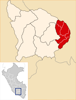
100:
90:
80:
21:
471:
8:
221:One of the highest peaks of the province is
119:2,612.72 km (1,008.78 sq mi)
478:
464:
456:
18:
411:
122:
109:
99:
79:
64:
36:
361:The people in the province are mainly
135:
127:
114:
89:
7:
437:INEI, Peru, Censos Nacionales 2007
14:
598:Provinces of the Apurímac Region
488:
66:
51:
41:
72:Location of Cotabambas in the
1:
614:
377:language and 0.17% using
16:Province in Apurímac, Peru
510:
433:January 27, 2013, at the
65:
37:
28:
140:17/km (44/sq mi)
137: • Density
570: /
242:Huch'uy Miyu Kancha
148:Cotabambas Province
451:www.cotabambas.com
317:Political division
211:Antabamba Province
129: • Total
116: • Total
574:13.942°S 72.181°W
553:
552:
144:
143:
605:
585:
584:
582:
581:
580:
579:-13.942; -72.181
575:
571:
568:
567:
566:
563:
492:
480:
473:
466:
457:
438:
425:
419:
416:
383:2007 Peru Census
203:Abancay Province
70:
55:
45:
19:
613:
612:
608:
607:
606:
604:
603:
602:
588:
587:
578:
576:
572:
569:
564:
561:
559:
557:
556:
554:
549:
506:
497:Apurímac Region
484:
447:
442:
441:
435:Wayback Machine
426:
422:
417:
413:
408:
391:
359:
319:
314:
254:Llulluch'a Urqu
219:
168:
156:Apurímac Region
154:located in the
76:
74:Apurímac Region
61:
60:
59:
58:
49:
48:
33:
24:
17:
12:
11:
5:
611:
609:
601:
600:
590:
589:
551:
550:
548:
547:
542:
537:
532:
527:
522:
517:
511:
508:
507:
505:
504:
499:
493:
485:
483:
482:
475:
468:
460:
454:
453:
446:
445:External links
443:
440:
439:
420:
410:
409:
407:
404:
403:
402:
397:
390:
387:
358:
355:
354:
353:
351:Challhuahuacho
348:
343:
338:
333:
328:
318:
315:
313:
312:
309:
306:
303:
300:
297:
294:
291:
288:
285:
284:Q'iswa Chakana
282:
279:
276:
273:
270:
267:
264:
261:
258:
255:
252:
249:
246:
243:
240:
237:
234:
231:
227:
218:
215:
214:
213:
196:
187:
178:
167:
164:
142:
141:
138:
134:
133:
130:
126:
125:
121:
120:
117:
113:
112:
108:
107:
102:
98:
97:
92:
88:
87:
82:
78:
77:
71:
63:
62:
56:
50:
46:
40:
39:
38:
35:
34:
29:
26:
25:
22:
15:
13:
10:
9:
6:
4:
3:
2:
610:
599:
596:
595:
593:
586:
583:
546:
543:
541:
538:
536:
533:
531:
528:
526:
523:
521:
518:
516:
513:
512:
509:
503:
500:
498:
495:Provinces of
494:
491:
487:
486:
481:
476:
474:
469:
467:
462:
461:
458:
452:
449:
448:
444:
436:
432:
429:
424:
421:
415:
412:
405:
401:
398:
396:
393:
392:
388:
386:
384:
380:
376:
372:
368:
364:
357:Ethnic groups
356:
352:
349:
347:
344:
342:
339:
337:
334:
332:
329:
327:
324:
323:
322:
316:
310:
307:
304:
301:
298:
295:
292:
289:
286:
283:
280:
278:Qhawana Marka
277:
274:
271:
268:
265:
262:
259:
257:Llulluch'ayuq
256:
253:
250:
247:
245:Jaqhira Sirka
244:
241:
238:
235:
233:Aqchi Wachana
232:
229:
228:
226:
224:
216:
212:
208:
207:Grau Province
204:
200:
197:
195:
191:
188:
186:
182:
179:
177:
173:
170:
169:
165:
163:
161:
157:
153:
149:
139:
131:
118:
106:
103:
96:
93:
86:
83:
75:
69:
54:
44:
32:
27:
20:
555:
539:
423:
414:
365:citizens of
360:
320:
311:Winku P'ukru
302:Wamanripayuq
230:Anka Wachana
220:
198:
194:Cusco Region
189:
185:Cusco Region
180:
176:Cusco Region
171:
147:
145:
57:Coat of arms
577: /
520:Andahuaylas
428:inei.gob.pe
400:Qiwllaqucha
305:Waqra Waqra
296:Taya Sirk'a
287:Q'umir Qaqa
565:72°10′52″W
562:13°56′31″S
540:Cotabambas
535:Chincheros
406:References
395:Markansaya
363:indigenous
336:Coyllurqui
331:Cotabambas
326:Tambobamba
266:Parqa Urqu
239:Ch'uwañuma
166:Boundaries
124:Population
105:Tambobamba
23:Cotabambas
525:Antabamba
369:descent.
308:Waraquyuq
275:Quña Quta
217:Geography
592:Category
530:Aymaraes
431:Archived
389:See also
293:Surimana
281:Qhillani
152:province
95:Apurímac
31:Province
515:Abancay
375:Spanish
371:Quechua
367:Quechua
341:Haquira
272:Phiruru
263:Ñiq'ita
260:Millpuq
248:Kunturi
101:Capital
81:Country
379:Aymara
299:T'akra
290:Sipita
236:Chunta
132:44,028
91:Region
269:Pukar
251:Limaq
223:Wiska
190:South
172:North
150:is a
545:Grau
502:Peru
346:Mara
199:West
181:East
160:Peru
146:The
111:Area
85:Peru
47:Flag
385:).
158:of
594::
209:,
205:,
201::
192::
183::
174::
479:e
472:t
465:v
381:(
Text is available under the Creative Commons Attribution-ShareAlike License. Additional terms may apply.