439:
427:
415:
80:
113:
403:
774:
60:
45:
637:
120:
87:
390:
Oog In 't Zeil was constructed in 1869. In 1904, an engine was installed in case there wasn't enough wind. In 1936, the top was removed, and only the base remained. In 1985, the remainder burnt down, and the entire windmill was rebuilt in 1987. It is still sometimes for grinding. The village used to
382:
was located on the other side of the river. The tower of the castle dates from the 14th century. The current building dates from 1873. The oldest parts of the Dutch
Reformed Church are from the 13th century. The church burned down in 1673, and was rebuilt in 1735 and extended in 1890.
834:
669:
438:
844:
662:
839:
655:
755:
854:
815:
204:
296:
79:
426:
308:
414:
148:
679:
554:
112:
361:
The village was first mentioned in the 12th century Coten, and means "little house/farm". Cothen developed into a stretched out
808:
402:
288:
192:
849:
801:
180:
647:
59:
546:
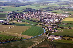
372:
267:
277:
44:
781:
697:
683:
641:
331:
327:
209:
197:
744:
739:
377:
734:
550:
342:
606:
468:
773:
785:
828:
368:
323:
185:
387:
519:
391:
be a separate municipality. In 1996, it became a part of Wijk bij
Duurstede.
163:
150:
718:
258:
17:
636:
346:
580:
363:
335:
284:
263:
16:
For the town in
Germany sometimes spelled in English as Cöthen, see
493:
651:
835:
Municipalities of the
Netherlands disestablished in 1996
789:
334:, and lies about 10 km (6 mi) southeast of
727:
706:
690:
307:
295:
274:
257:
249:
241:
236:
228:
220:
215:
203:
191:
179:
28:
809:
756:List of cities, towns and villages in Utrecht
663:
8:
386:In 1840, Cothen was home to 665 people. The
341:The skyline of Cothen is characterized by a
845:Former municipalities of Utrecht (province)
545:Ronald Stenvert & Chris Kolman (1996).
816:
802:
670:
656:
648:
25:
575:
573:
455:
398:
294:
256:
235:
227:
214:
178:
143:
71:
53:
41:
840:Populated places in Utrecht (province)
463:
461:
459:
444:Church: the Sint-Petrus and Pauluskerk
330:. It is a part of the municipality of
306:
273:
248:
240:
219:
202:
190:
7:
770:
768:
469:"Kerncijfers wijken en buurten 2021"
224:11.93 km (4.61 sq mi)
855:Utrecht (province) geography stubs
14:
772:
635:
437:
425:
413:
401:
118:
111:
85:
78:
58:
43:
500:(in Dutch). Het Waterschapshuis
498:Actueel Hoogtebestand Nederland
23:Village in Utrecht, Netherlands
549:(in Dutch). Zwolle: Waanders.
520:"Cothen - (geografische naam)"
119:
102:Show map of Utrecht (province)
86:
1:
788:. You can help Knowledge by
473:Central Bureau of Statistics
99:Location in the Netherlands
871:
767:
15:
753:
494:"Postcodetool for 3945BA"
144:
72:
54:
42:
35:
678:Populated places in the
253:270/km (710/sq mi)
135:Show map of Netherlands
784:location article is a
276: • Summer (
232:4 m (13 ft)
644:at Wikimedia Commons
432:View along the canal
322:is a village in the
250: • Density
164:51.99611°N 5.30972°E
132:Cothen (Netherlands)
408:Snack bar in Cothen
160: /
49:Cothen from the air
850:Wijk bij Duurstede
698:Wijk bij Duurstede
684:Wijk bij Duurstede
420:Castle Rhijnestein
373:Castle Rhijnestein
332:Wijk bij Duurstede
242: • Total
221: • Total
210:Wijk bij Duurstede
797:
796:
762:
761:
640:Media related to
317:
316:
169:51.99611; 5.30972
862:
818:
811:
804:
776:
769:
672:
665:
658:
649:
639:
623:
622:
620:
618:
607:"Oog in 't Zeil"
603:
597:
596:
594:
592:
577:
568:
567:
565:
563:
542:
536:
535:
533:
531:
516:
510:
509:
507:
505:
490:
484:
483:
481:
479:
465:
441:
429:
417:
405:
381:
281:
175:
174:
172:
171:
170:
165:
161:
158:
157:
156:
153:
136:
122:
121:
115:
103:
89:
88:
82:
62:
47:
26:
870:
869:
865:
864:
863:
861:
860:
859:
825:
824:
823:
822:
765:
763:
758:
749:
723:
702:
686:
676:
632:
627:
626:
616:
614:
605:
604:
600:
590:
588:
579:
578:
571:
561:
559:
557:
544:
543:
539:
529:
527:
524:Etymologie bank
518:
517:
513:
503:
501:
492:
491:
487:
477:
475:
467:
466:
457:
452:
445:
442:
433:
430:
421:
418:
409:
406:
397:
375:
359:
303:
275:
168:
166:
162:
159:
154:
151:
149:
147:
146:
140:
139:
138:
137:
134:
133:
130:
129:
128:
127:
123:
106:
105:
104:
101:
100:
97:
96:
95:
94:
90:
68:
67:
66:
65:
50:
38:
31:
24:
21:
12:
11:
5:
868:
866:
858:
857:
852:
847:
842:
837:
827:
826:
821:
820:
813:
806:
798:
795:
794:
777:
760:
759:
754:
751:
750:
748:
747:
742:
737:
731:
729:
725:
724:
722:
721:
716:
710:
708:
704:
703:
701:
700:
694:
692:
688:
687:
677:
675:
674:
667:
660:
652:
646:
645:
631:
630:External links
628:
625:
624:
611:Molen database
598:
569:
555:
537:
511:
485:
454:
453:
451:
448:
447:
446:
443:
436:
434:
431:
424:
422:
419:
412:
410:
407:
400:
396:
393:
358:
355:
351:Oog In 't Zeil
315:
314:
311:
305:
304:
301:
299:
293:
292:
282:
272:
271:
261:
255:
254:
251:
247:
246:
243:
239:
238:
234:
233:
230:
226:
225:
222:
218:
217:
213:
212:
207:
201:
200:
195:
189:
188:
183:
177:
176:
142:
141:
131:
125:
124:
117:
116:
110:
109:
108:
107:
98:
92:
91:
84:
83:
77:
76:
75:
74:
73:
70:
69:
63:
57:
56:
55:
52:
51:
48:
40:
39:
36:
33:
32:
29:
22:
13:
10:
9:
6:
4:
3:
2:
867:
856:
853:
851:
848:
846:
843:
841:
838:
836:
833:
832:
830:
819:
814:
812:
807:
805:
800:
799:
793:
791:
787:
783:
778:
775:
771:
766:
757:
752:
746:
743:
741:
738:
736:
733:
732:
730:
726:
720:
717:
715:
712:
711:
709:
705:
699:
696:
695:
693:
689:
685:
681:
673:
668:
666:
661:
659:
654:
653:
650:
643:
638:
634:
633:
629:
612:
608:
602:
599:
586:
582:
576:
574:
570:
558:
556:90 400 9757 7
552:
548:
541:
538:
525:
521:
515:
512:
499:
495:
489:
486:
474:
470:
464:
462:
460:
456:
449:
440:
435:
428:
423:
416:
411:
404:
399:
394:
392:
389:
384:
379:
374:
370:
366:
365:
356:
354:
352:
348:
344:
339:
337:
333:
329:
325:
321:
312:
310:
300:
298:
290:
286:
283:
279:
269:
265:
262:
260:
252:
244:
231:
223:
211:
208:
206:
199:
196:
194:
187:
184:
182:
173:
145:Coordinates:
114:
81:
61:
46:
34:
27:
19:
790:expanding it
779:
764:
713:
680:municipality
615:. Retrieved
610:
601:
589:. Retrieved
585:Plaatsengids
584:
560:. Retrieved
540:
528:. Retrieved
523:
514:
502:. Retrieved
497:
488:
476:. Retrieved
472:
385:
362:
360:
350:
340:
326:province of
319:
318:
309:Dialing code
205:Municipality
64:Coat of arms
376: [
369:Kromme Rijn
297:Postal code
186:Netherlands
167: /
829:Categories
745:Sandenburg
613:(in Dutch)
587:(in Dutch)
526:(in Dutch)
450:References
388:grist mill
367:along the
237:Population
152:51°59′46″N
740:Dwarsdijk
719:Langbroek
259:Time zone
229:Elevation
155:5°18′35″E
735:Den Oord
707:Villages
617:26 March
591:26 March
581:"Cothen"
562:26 March
547:"Cothen"
530:26 March
504:26 March
478:26 March
347:windmill
193:Province
782:Utrecht
728:Hamlets
395:Gallery
357:History
349:called
328:Utrecht
198:Utrecht
181:Country
37:Village
714:Cothen
642:Cothen
553:
364:esdorp
345:and a
343:church
336:Houten
320:Cothen
126:Cothen
93:Cothen
30:Cothen
18:Köthen
780:This
691:Towns
380:]
324:Dutch
285:UTC+2
264:UTC+1
245:3,275
786:stub
619:2022
593:2022
564:2022
551:ISBN
532:2022
506:2022
480:2022
313:0343
302:3945
289:CEST
216:Area
682:of
278:DST
268:CET
831::
609:.
583:.
572:^
522:.
496:.
471:.
458:^
378:nl
371:.
353:.
338:.
817:e
810:t
803:v
792:.
671:e
664:t
657:v
621:.
595:.
566:.
534:.
508:.
482:.
291:)
287:(
280:)
270:)
266:(
20:.
Text is available under the Creative Commons Attribution-ShareAlike License. Additional terms may apply.