30:
761:
751:
117:
784:
392:
37:
198:
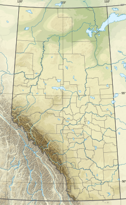
233:, to fill the reservoir. The main drainage flowing from the Crawling Valley Reservoir flows through a continuation of the North Branch Canal, serving irrigation needs, with other outflow into the Matzhiwin Creek.
29:
825:
257:
225:
created during the letting of the
Laurentide ice sheet at the end of the last ice age. Construction of dams and canals began in 1983, diverting some water from the
76:
854:
818:
250:
811:
243:
341:
736:
637:
311:
731:
849:
844:
700:
617:
421:
278:
391:
499:
461:
381:
346:
559:
519:
361:
524:
514:
504:
612:
564:
549:
529:
509:
489:
326:
296:
695:
469:
494:
632:
544:
331:
229:
via the North Branch Canal, starting just upstream of the
Bassano Dam (southwest of the town of
675:
665:
602:
534:
222:
791:
710:
680:
607:
336:
230:
188:
58:
627:
479:
441:
411:
316:
286:
795:
726:
705:
685:
647:
474:
451:
426:
366:
108:
838:
755:
690:
622:
539:
446:
306:
221:. The reservoir uses the existing Crawling Valley, which was depression created as a
783:
765:
597:
592:
574:
569:
484:
351:
291:
554:
670:
642:
436:
431:
376:
371:
356:
321:
266:
91:
78:
584:
416:
403:
301:
226:
214:
235:
657:
270:
218:
62:
122:
239:
390:
799:
719:
656:
583:
460:
402:
277:
194:
184:
180:
172:
164:
156:
148:
140:
132:
128:
107:
68:
54:
18:
36:
69:
819:
251:
8:
826:
812:
258:
244:
236:
15:
7:
780:
778:
152:25.1 km (9.7 sq mi)
14:
855:Southern Alberta geography stubs
782:
759:
749:
115:
35:
28:
171:
163:
155:
147:
139:
131:
1:
53:
798:. You can help Knowledge by
737:Whooping Crane Summer Range
395:Rivers and lakes in Alberta
871:
777:
176:778 m (2,552 ft)
746:
618:Little Bow Lake Reservoir
388:
207:Crawling Valley Reservoir
199:Crawling Valley Reservoir
144:7.2 km (4.5 mi)
43:Crawling Valley Reservoir
23:
19:Crawling Valley Reservoir
136:12 km (7.5 mi)
160:5.2 m (17 ft)
794:location article is a
396:
168:16 m (52 ft)
92:50.90194°N 112.35278°W
732:Peace–Athabasca Delta
394:
97:50.90194; -112.35278
88: /
545:North Wabasca Lake
397:
382:South Saskatchewan
347:North Saskatchewan
807:
806:
772:
771:
756:Rivers portal
727:Hay-Zama Wetlands
676:Columbia Icefield
223:meltwater channel
204:
203:
173:Surface elevation
862:
850:County of Newell
845:Lakes of Alberta
828:
821:
814:
792:Southern Alberta
786:
779:
766:Lakes portal
764:
763:
762:
754:
753:
752:
711:Waputik Icefield
638:Milk River Ridge
260:
253:
246:
237:
211:Barkenhouse Lake
121:
119:
118:
103:
102:
100:
99:
98:
93:
89:
86:
85:
84:
81:
71:
59:County of Newell
39:
38:
32:
16:
870:
869:
865:
864:
863:
861:
860:
859:
835:
834:
833:
832:
775:
773:
768:
760:
758:
750:
748:
742:
715:
652:
579:
456:
398:
386:
273:
264:
116:
114:
111: countries
96:
94:
90:
87:
82:
79:
77:
75:
74:
50:
49:
48:
47:
46:
45:
44:
40:
12:
11:
5:
868:
866:
858:
857:
852:
847:
837:
836:
831:
830:
823:
816:
808:
805:
804:
787:
770:
769:
747:
744:
743:
741:
740:
734:
729:
723:
721:
717:
716:
714:
713:
708:
703:
698:
693:
688:
683:
678:
673:
668:
662:
660:
654:
653:
651:
650:
645:
640:
635:
630:
625:
620:
615:
610:
605:
600:
595:
589:
587:
581:
580:
578:
577:
572:
567:
562:
557:
552:
547:
542:
537:
532:
527:
522:
517:
512:
507:
502:
497:
492:
487:
482:
477:
472:
466:
464:
458:
457:
455:
454:
449:
444:
439:
434:
429:
424:
419:
414:
408:
406:
400:
399:
389:
387:
385:
384:
379:
374:
369:
364:
359:
354:
349:
344:
339:
334:
329:
324:
319:
314:
309:
304:
299:
294:
289:
283:
281:
275:
274:
265:
263:
262:
255:
248:
240:
202:
201:
196:
192:
191:
186:
182:
181:
178:
177:
174:
170:
169:
166:
162:
161:
158:
154:
153:
150:
146:
145:
142:
138:
137:
134:
130:
129:
126:
125:
112:
105:
104:
72:
66:
65:
56:
52:
51:
42:
41:
34:
33:
27:
26:
25:
24:
21:
20:
13:
10:
9:
6:
4:
3:
2:
867:
856:
853:
851:
848:
846:
843:
842:
840:
829:
824:
822:
817:
815:
810:
809:
803:
801:
797:
793:
788:
785:
781:
776:
767:
757:
745:
738:
735:
733:
730:
728:
725:
724:
722:
718:
712:
709:
707:
704:
702:
699:
697:
694:
692:
689:
687:
684:
682:
679:
677:
674:
672:
669:
667:
664:
663:
661:
659:
655:
649:
646:
644:
641:
639:
636:
634:
631:
629:
626:
624:
621:
619:
616:
614:
611:
609:
606:
604:
601:
599:
596:
594:
591:
590:
588:
586:
582:
576:
573:
571:
568:
566:
563:
561:
558:
556:
553:
551:
548:
546:
543:
541:
538:
536:
533:
531:
528:
526:
523:
521:
518:
516:
513:
511:
508:
506:
503:
501:
498:
496:
493:
491:
488:
486:
483:
481:
478:
476:
473:
471:
468:
467:
465:
463:
459:
453:
450:
448:
445:
443:
440:
438:
435:
433:
430:
428:
425:
423:
420:
418:
415:
413:
410:
409:
407:
405:
401:
393:
383:
380:
378:
375:
373:
370:
368:
365:
363:
360:
358:
355:
353:
350:
348:
345:
343:
340:
338:
335:
333:
330:
328:
325:
323:
320:
318:
315:
313:
310:
308:
305:
303:
300:
298:
295:
293:
290:
288:
285:
284:
282:
280:
276:
272:
268:
261:
256:
254:
249:
247:
242:
241:
238:
234:
232:
228:
224:
220:
216:
212:
208:
200:
197:
193:
190:
187:
183:
179:
175:
167:
159:
157:Average depth
151:
143:
135:
127:
124:
113:
110:
106:
101:
73:
67:
64:
60:
57:
31:
22:
17:
800:expanding it
789:
774:
696:Saskatchewan
535:Lesser Slave
210:
206:
205:
149:Surface area
608:Chestermere
422:Bridal Veil
267:Hydrography
185:Settlements
133:Max. length
95: /
83:112°21′10″W
70:Coordinates
839:Categories
739:(wetlands)
628:Minnewanka
613:Kananaskis
585:Reservoirs
480:Beaverhill
404:Waterfalls
337:Little Bow
312:Clearwater
195:References
165:Max. depth
141:Max. width
80:50°54′07″N
666:Athabasca
648:Gleniffer
560:Ste. Anne
500:Crowsnest
475:Athabasca
442:Lundbreck
412:Athabasca
317:Crowsnest
287:Athabasca
227:Bow River
215:reservoir
681:Crowfoot
658:Glaciers
633:Glenmore
623:McGregor
540:Miquelon
525:La Biche
520:Jackfish
505:Des Arcs
452:Sunwapta
427:Crescent
367:Red Deer
55:Location
701:Vulture
603:Brazeau
598:Barrier
593:Abraham
575:Wabamun
570:Utikuma
530:St. Cyr
515:Hubbles
485:Bistcho
447:Panther
362:Pembina
307:Brazeau
271:Alberta
231:Bassano
219:Alberta
213:, is a
189:Bassano
63:Alberta
686:Hector
643:Sikome
565:Sylvan
550:Pigeon
510:Garner
490:Claire
352:Oldman
297:Beaver
292:Battle
279:Rivers
123:Canada
120:
790:This
720:Other
706:Wapta
691:Peyto
555:Santé
470:Amisk
462:Lakes
437:Elbow
432:Crypt
377:Smoky
372:Slave
357:Peace
327:Ghost
322:Elbow
209:, or
109:Basin
796:stub
495:Cold
342:Milk
671:Bow
417:Bow
332:Hay
302:Bow
269:of
217:in
841::
61:,
827:e
820:t
813:v
802:.
259:e
252:t
245:v
Text is available under the Creative Commons Attribution-ShareAlike License. Additional terms may apply.