55:
279:
268:
284:
62:
1011:
944:
415:. A glacier on the north side of Edward VII Peninsula, flowing northeast along, the east side of Howard Heights into Sulzberger Ice Shelf. Mapped by USGS from surveys and United States Navy air photos, 1959-65. Named by US-ACAN for Lieutenant Commander Wayne B. Stewart, United States Navy, co-pilot in LC-130F Hercules aircraft during
699:
on the south, in the Ford Ranges. Discovered by members of West Base of the US AS, in aerial flights and from ground surveys in
November-December 1940. Named by US-SCAN for R. Admiral Arthur C. Davis, United States Navy, a leader in aviation in the United States Navy.
365:. A snow covered coastal promontory 515 metres (1,690 ft) high between Stewart Glacier and Gerry Glacier on the north side of Edward VII Peninsula. Features in this area were explored by the ByrdAE, 1928-30 and 1933-35. These heights were mapped by the
507:, flowing northwest for about 40 nautical miles (74 km; 46 mi) to Sulzberger Ice Shelf in the Ford Ranges. Discovered in 1934 by the ByrdAE, and named by Byrd for John Hays Hammond, American mining engineer and philanthropist.
1015:
948:
595:, into Sulzberger Ice Shelf. Features in these ranges were discovered and successively mapped by the ByrdAE (1928-30) and (1933-35) and by the USAS (1939-41) all led by R. Admiral R.E. Byrd. The glacier is named for
549:
to enter the
Hammond Glacier. Mapped by USGS from surveys and United States Navy air photos, 1959-65. Named by US-ACAN for Donald K. Reynolds, ionospheric physicist at Byrd Station, 1967-68 season.
465:. Discovered on the ByrdAE flight of December 5, 1929. Named by Byrd for Grace McKinley, wife of Captain Ashley C. McKinley, aerial photographer and third in command of the expedition.
294:
The landward side of the
Sulzberger Ice Shelf extends southeast from Howard Heights and the mouth of the Stewart Glacier to McKinley Peak. From there it runs northeast past the
649:
in the Ford Ranges. Discovered on aerial flights of the ByrdAE in 1934, and named for Vernon D. Boyd, expedition machinist, and a member of West Base of the USAS (1939–41).
78:
746:. Discovered by a sledging party of the ByrdAE, which visited this area in November-December 1934, and so named because of its extensively crevassed surface.
54:
147:
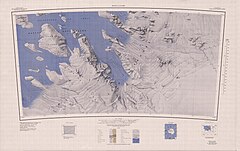
184:) is an ice shelf about 85 nautical miles (157 km; 98 mi) long and 50 nautical miles (93 km; 58 mi) wide bordering the coast of
952:
641:. Heavily crevassed glacier flowing west-northwest for about 45 nautical miles (83 km; 52 mi) to the Sulzberger Ice Shelf between
213:
1035:
545:. A glacier 5 nautical miles (9.3 km; 5.8 mi) long, flowing eastward from the Haines Mountains along the south side of
588:
1019:
366:
1040:
687:. Valley glacier about 25 nautical miles (46 km; 29 mi) long, flowing west to Sulzberger Ice Shelf between the
710:
659:
613:
559:
517:
475:
429:
387:
337:
229:
696:
306:. It then runs north past the mouth of the Crevasse Valley Glacier and northwest along the southern edge of the
205:
369:(USGS) from surveys and United States Navy air photos, 1959-65. Named by US-ACAN (at the suggestion of Admiral
256:
278:
738:. A broad glacier about 30 nautical miles (56 km; 35 mi) long, flowing west-southwest between
251:
416:
319:
246:
189:
267:
302:, past the mouths of the Hammond Glacier, Swope Glacier, Boyd Glacier and Arthur Glacier to the
283:
959:
743:
739:
688:
303:
600:
504:
311:
991:
377:
of the
ScrippsHoward newspapers, who made financial contributions to the ByrdAE, 1933-35.
370:
307:
193:
185:
122:
975:
646:
546:
315:
209:
133:
17:
1029:
458:
374:
295:
241:
926:
642:
596:
310:. The seaward side extends in a generally northeast direction from the tip of the
603:, who contributed various types of electrical equipment to the ByrdAE (1933-35).
462:
299:
592:
725:
712:
674:
661:
628:
615:
574:
561:
532:
519:
490:
477:
444:
431:
402:
389:
352:
339:
163:
149:
94:
80:
692:
41:
314:
to the tip of the Guest
Peninsula. The seaward side forms the shore of
457:. A peak standing 15 nautical miles (28 km; 17 mi) west of
216:(US-ACAN) extended the name Sulzberger to the adjacent ice shelf.
587:. A glacier which drains westward from the Ford Ranges, between
204:
The
Sulzberger Ice Shelf was observed and roughly mapped by the
212:
to the open water indenting this feature. The United States
760:
758:
934:(2 ed.), United States Board on Geographic Names
776:
129:
118:
32:
800:
788:
8:
61:
208:(ByrdAE; 1928-30), which applied the name
29:
503:. Glacier on the northeast side of the
322:are scattered throughout the ice shelf.
266:
996:, USGS: United States Geological Survey
980:, USGS: United States Geological Survey
964:, USGS: United States Geological Survey
953:United States Board on Geographic Names
908:
896:
884:
872:
860:
848:
836:
824:
812:
764:
754:
117:
47:
214:Advisory Committee on Antarctic Names
128:
7:
1018:from websites or documents of the
951:from websites or documents of the
25:
928:Geographic Names of the Antarctic
1014: This article incorporates
1009:
947: This article incorporates
942:
282:
277:
60:
53:
1020:United States Geological Survey
367:United States Geological Survey
925:Alberts, Fred G., ed. (1995),
1:
257:GPX (secondary coordinates)
1057:
289:Southern part of ice shelf
271:Northern part of ice shelf
1036:Ice shelves of Antarctica
252:GPX (primary coordinates)
227:Map all coordinates using
206:Byrd Antarctic Expedition
74:
48:
39:
777:Alexandra Mountains USGS
461:at the south end of the
235:Download coordinates as:
704:Crevasse Valley Glacier
27:Ice shelf in Antarctica
18:Crevasse Valley Glacier
1016:public domain material
949:public domain material
318:. The islands of the
272:
417:Operation Deep Freeze
270:
247:GPX (all coordinates)
130:Offshore water bodies
1041:King Edward VII Land
801:Guest Peninsula USGS
320:Marshall Archipelago
200:Exploration and name
190:Edward VII Peninsula
175:Sulzberger Ice Shelf
142:Sulzberger Ice Shelf
106:Sulzberger Ice Shelf
34:Sulzberger Ice Shelf
961:Alexandra Mountains
911:, pp. 161–162.
722: /
671: /
625: /
571: /
529: /
487: /
441: /
399: /
349: /
159: /
90: /
765:Alberts & 1995
726:76.767°S 145.500°W
675:77.050°S 145.250°W
629:77.233°S 145.417°W
575:77.333°S 145.833°W
533:77.633°S 145.917°W
491:77.417°S 146.000°W
445:77.900°S 148.300°W
403:77.483°S 151.417°W
353:77.450°S 151.667°W
273:
164:77.000°S 148.000°W
95:77.000°S 148.000°W
789:Boyd Glacier USGS
744:Saunders Mountain
740:Chester Mountains
731:-76.767; -145.500
691:on the north and
689:Swanson Mountains
680:-77.050; -145.250
634:-77.233; -145.417
580:-77.333; -145.833
538:-77.633; -145.917
496:-77.417; -146.000
450:-77.900; -148.300
408:-77.483; -151.417
358:-77.450; -151.667
304:Denfeld Mountains
169:-77.000; -148.000
139:
138:
100:-77.000; -148.000
16:(Redirected from
1048:
1013:
1012:
1003:
1002:
1001:
987:
986:
985:
971:
970:
969:
946:
945:
941:
940:
939:
933:
912:
906:
900:
894:
888:
882:
876:
870:
864:
858:
852:
846:
840:
834:
828:
822:
816:
810:
804:
798:
792:
786:
780:
774:
768:
762:
737:
736:
734:
733:
732:
727:
723:
720:
719:
718:
715:
686:
685:
683:
682:
681:
676:
672:
669:
668:
667:
664:
640:
639:
637:
636:
635:
630:
626:
623:
622:
621:
618:
601:General Electric
586:
585:
583:
582:
581:
576:
572:
569:
568:
567:
564:
544:
543:
541:
540:
539:
534:
530:
527:
526:
525:
522:
511:Reynolds Glacier
505:Haines Mountains
502:
501:
499:
498:
497:
492:
488:
485:
484:
483:
480:
456:
455:
453:
452:
451:
446:
442:
439:
438:
437:
434:
414:
413:
411:
410:
409:
404:
400:
397:
396:
395:
392:
364:
363:
361:
360:
359:
354:
350:
347:
346:
345:
342:
312:Reeves Peninsula
286:
281:
183:
182:
180:
179:
178:
176:
171:
170:
165:
160:
157:
156:
155:
152:
114:
113:
111:
110:
109:
107:
102:
101:
96:
91:
88:
87:
86:
83:
64:
63:
57:
30:
21:
1056:
1055:
1051:
1050:
1049:
1047:
1046:
1045:
1026:
1025:
1010:
1006:
999:
997:
993:Guest Peninsula
990:
983:
981:
974:
967:
965:
958:
943:
937:
935:
931:
924:
920:
915:
907:
903:
895:
891:
883:
879:
871:
867:
859:
855:
847:
843:
835:
831:
823:
819:
811:
807:
799:
795:
787:
783:
775:
771:
763:
756:
752:
730:
728:
724:
721:
716:
713:
711:
709:
708:
706:
679:
677:
673:
670:
665:
662:
660:
658:
657:
655:
633:
631:
627:
624:
619:
616:
614:
612:
611:
609:
599:, president of
579:
577:
573:
570:
565:
562:
560:
558:
557:
555:
537:
535:
531:
528:
523:
520:
518:
516:
515:
513:
495:
493:
489:
486:
481:
478:
476:
474:
473:
471:
469:Hammond Glacier
449:
447:
443:
440:
435:
432:
430:
428:
427:
425:
407:
405:
401:
398:
393:
390:
388:
386:
385:
383:
381:Stewart Glacier
371:Richard E. Byrd
357:
355:
351:
348:
343:
340:
338:
336:
335:
333:
328:
308:Guest Peninsula
292:
291:
290:
287:
265:
264:
263:
262:
261:
222:
202:
196:in Antarctica.
194:Guest Peninsula
186:Marie Byrd Land
174:
172:
168:
166:
162:
161:
158:
153:
150:
148:
146:
145:
123:Marie Byrd Land
105:
103:
99:
97:
93:
92:
89:
84:
81:
79:
77:
76:
70:
69:
68:
67:
66:
65:
44:
35:
28:
23:
22:
15:
12:
11:
5:
1054:
1052:
1044:
1043:
1038:
1028:
1027:
1024:
1023:
1005:
1004:
988:
972:
956:
921:
919:
916:
914:
913:
901:
889:
877:
875:, p. 729.
865:
863:, p. 615.
853:
851:, p. 308.
841:
839:, p. 478.
829:
827:, p. 713.
817:
815:, p. 350.
805:
793:
781:
769:
767:, p. 723.
753:
751:
748:
705:
702:
654:
653:Arthur Glacier
651:
647:Mount Douglass
608:
605:
589:Mount Woodward
554:
551:
547:Keyser Nunatak
512:
509:
470:
467:
424:
421:
382:
379:
332:
331:Howard Heights
329:
327:
324:
316:Sulzberger Bay
288:
276:
275:
274:
260:
259:
254:
249:
244:
238:
232:
225:
224:
223:
221:
218:
210:Sulzberger Bay
201:
198:
137:
136:
134:Southern Ocean
131:
127:
126:
120:
116:
115:
72:
71:
59:
58:
52:
51:
50:
49:
46:
45:
40:
37:
36:
33:
26:
24:
14:
13:
10:
9:
6:
4:
3:
2:
1053:
1042:
1039:
1037:
1034:
1033:
1031:
1021:
1017:
1008:
1007:
995:
994:
989:
979:
978:
973:
963:
962:
957:
954:
950:
930:
929:
923:
922:
917:
910:
905:
902:
899:, p. 29.
898:
893:
890:
887:, p. 86.
886:
881:
878:
874:
869:
866:
862:
857:
854:
850:
845:
842:
838:
833:
830:
826:
821:
818:
814:
809:
806:
802:
797:
794:
790:
785:
782:
778:
773:
770:
766:
761:
759:
755:
749:
747:
745:
741:
735:
703:
701:
698:
694:
690:
684:
652:
650:
648:
644:
638:
606:
604:
602:
598:
594:
590:
584:
553:Swope Glacier
552:
550:
548:
542:
510:
508:
506:
500:
468:
466:
464:
460:
459:Hershey Ridge
454:
423:McKinley Peak
422:
420:
418:
412:
380:
378:
376:
375:Roy W. Howard
372:
368:
362:
330:
325:
323:
321:
317:
313:
309:
305:
301:
297:
296:Hershey Ridge
285:
280:
269:
258:
255:
253:
250:
248:
245:
243:
240:
239:
237:
236:
231:
230:OpenStreetMap
228:
219:
217:
215:
211:
207:
199:
197:
195:
191:
187:
181:
143:
135:
132:
124:
121:
112:
75:Coordinates:
73:
56:
43:
38:
31:
19:
998:, retrieved
992:
982:, retrieved
977:Boyd Glacier
976:
966:, retrieved
960:
936:, retrieved
927:
909:Alberts 1995
904:
897:Alberts 1995
892:
885:Alberts 1995
880:
873:Alberts 1995
868:
861:Alberts 1995
856:
849:Alberts 1995
844:
837:Alberts 1995
832:
825:Alberts 1995
820:
813:Alberts 1995
808:
796:
784:
772:
707:
697:Mount Cooper
656:
643:Bailey Ridge
610:
607:Boyd Glacier
597:Gerard Swope
556:
514:
472:
426:
384:
334:
293:
234:
233:
226:
203:
141:
140:
125:, Antarctica
729: /
678: /
632: /
578: /
536: /
494: /
463:Ford Ranges
448: /
406: /
356: /
300:Court Ridge
167: /
98: /
1030:Categories
1000:2024-03-25
984:2024-03-25
968:2024-03-25
938:2023-12-03
750:References
593:Mount West
173: (
104: (
693:Mount Rea
42:Ice shelf
717:145°30′W
666:145°15′W
620:145°25′W
566:145°50′W
524:145°55′W
482:146°00′W
436:148°18′W
394:151°25′W
344:151°40′W
326:Features
298:and the
220:Location
188:between
154:148°00′W
119:Location
85:148°00′W
918:Sources
714:76°46′S
663:77°03′S
617:77°14′S
563:77°20′S
521:77°38′S
479:77°25′S
433:77°54′S
391:77°29′S
341:77°27′S
151:77°00′S
82:77°00′S
419:1968.
373:) for
932:(PDF)
742:and
695:and
645:and
591:and
192:and
242:KML
1032::
757:^
1022:.
955:.
803:.
791:.
779:.
177:)
144:(
108:)
20:)
Text is available under the Creative Commons Attribution-ShareAlike License. Additional terms may apply.