72:
125:
389:
180:
Opened in 1980, the Tunnel of Christ the
Redeemer (Spanish: Túnel Cristo Redentor) is 3,080 m (10,105 ft) long, and serves as an important land crossing between Chile and Argentina. At the middle of the tunnel is the national border, which is the termini of
210:
at an elevation of 3,832 m (12,572 ft). The pass was the highest point of the road before the opening of the tunnel lowered the maximum elevation by 600 m (1,969 ft), eliminated 65 switchbacks and shortened the route by 10 km (6 mi).
172:
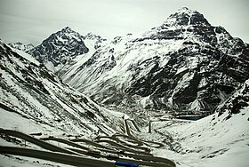
From the
Argentine side the route to the pass is a slow, gentle incline until entering a tunnel at approximately 3,200 meters (10,500 feet) elevation. On the Chilean side the slope has a far higher grade, and the road descends down a long series of
214:
On 19 September 2013, nearly 15,000 Chileans got stranded on the
Argentine side, when the pass had to be closed for 10 hours because of freezing temperatures and between 40 and 50 centimeters of snow.
289:
422:
230:
Tunnel"), which would be constructed at an altitude of between 2,250 and 2,720 m (7,382 and 8,924 ft), 20 km (12 mi) long, to join the towns of
614:
222:
In order to ease the dependence on the only tunnel in the area and to permit year-round crossing, two lower tunnels have been proposed. One of them is the
415:
297:
624:
669:
311:
619:
674:
639:
634:
408:
32:
249:
Pass"), at an elevation of 2,050 m (6,726 ft) and 13 km (8 mi) of length, would connect El
Sosneado in Argentina (near
374:
654:
365:
343:
629:
71:
352:
198:
357:
584:
347:
659:
649:
260:
The
Aconcagua Bi-Oceanic railway is a proposal for a 52-kilometre-long (32 mi) railway base tunnel under this pass.
186:
461:
370:
124:
644:
481:
471:
231:
664:
319:
476:
466:
112:
269:
250:
235:
189:. The path can be closed during winter because of heavy snows blocking both ends and the threat of
82:
456:
524:
519:
378:
569:
564:
559:
534:
227:
161:
529:
290:"Nearly 15,000 Chileans Stranded at Paso Internacional Los Libertadores Border Crossing"
554:
549:
539:
207:
182:
107:
388:
17:
608:
431:
141:
579:
574:
514:
504:
394:
174:
246:
400:
384:
254:
47:
34:
509:
491:
149:
95:
190:
157:
443:
495:
447:
435:
153:
145:
123:
116:
99:
156:. It is the main transport route out of the Chilean capital city
404:
366:
Updated state of different tunnels and crossings in
Argentina
596:
Note: Passes are ordered by latitude from north to south
490:
442:
106:
91:
81:
64:
164:in Argentina and so carries quite heavy traffic.
416:
8:
76:Switchbacks on the Chilean side of the pass
423:
409:
401:
61:
27:Mountain pass between Chile and Argentina
281:
128:The Chilean tunnel entrance in winter
7:
134:Paso Internacional Los Libertadores
25:
206:) statue placed in 1904 near the
196:Its name comes from the four-ton
670:1980 establishments in Argentina
615:Argentina–Chile border crossings
387:
199:Christ the Redeemer of the Andes
70:
312:"Caos en Paso Los Libertadores"
241:Another proposed tunnel, named
625:Landforms of Valparaíso Region
348:Argentine National Gendarmerie
1:
620:Landforms of Mendoza Province
675:1980 establishments in Chile
640:Mountain passes of the Andes
635:Mountain passes of Argentina
318:. 2013-09-23. Archived from
296:. 2013-09-21. Archived from
218:Alternative proposed tunnels
204:Cristo Redentor de los Andes
691:
655:Tunnels completed in 1980
593:
69:
630:Mountain passes of Chile
377:Facultad de San Rafael,
585:Cardenal Antonio Samoré
462:Chungara–Tambo Quemado
346:of Cristo Redentor by
129:
18:Cristo Redentor Tunnel
177:to make the descent.
127:
65:Los Libertadores Pass
48:32.82724°S 70.09213°W
660:Principal Cordillera
650:Tunnels in Argentina
482:Portezuelo del Cajón
477:Portezuelo de Chaxas
353:Tunnels in Argentina
113:Principal Cordillera
53:-32.82724; -70.09213
270:Transandine Railway
232:Horcones, Argentina
224:Túnel Juan Pablo II
87:3,200 m (10,499 ft)
44: /
130:
602:
601:
597:
187:Argentina Route 7
122:
121:
16:(Redirected from
682:
645:Tunnels in Chile
595:
472:Salar de Ollagüe
425:
418:
411:
402:
397:
392:
391:
331:
330:
328:
327:
308:
302:
301:
286:
162:Mendoza Province
74:
62:
59:
58:
56:
55:
54:
49:
45:
42:
41:
40:
37:
21:
690:
689:
685:
684:
683:
681:
680:
679:
605:
604:
603:
598:
589:
486:
467:Colchane–Pisiga
438:
432:Mountain passes
429:
393:
386:
359:Cristo Redentor
340:
335:
334:
325:
323:
310:
309:
305:
288:
287:
283:
278:
266:
220:
170:
138:Cristo Redentor
77:
52:
50:
46:
43:
38:
35:
33:
31:
30:
28:
23:
22:
15:
12:
11:
5:
688:
686:
678:
677:
672:
667:
662:
657:
652:
647:
642:
637:
632:
627:
622:
617:
607:
606:
600:
599:
594:
591:
590:
588:
587:
582:
577:
572:
567:
562:
557:
552:
547:
542:
537:
532:
527:
522:
517:
512:
507:
501:
499:
488:
487:
485:
484:
479:
474:
469:
464:
459:
453:
451:
440:
439:
430:
428:
427:
420:
413:
405:
399:
398:
383:
382:
371:Paso Las Leñas
368:
363:
355:
350:
339:
338:External links
336:
333:
332:
303:
300:on 2013-12-15.
280:
279:
277:
274:
273:
272:
265:
262:
243:Paso Las Leñas
219:
216:
208:Uspallata Pass
183:Chile Route 60
169:
166:
136:, also called
120:
119:
110:
104:
103:
93:
89:
88:
85:
79:
78:
75:
67:
66:
26:
24:
14:
13:
10:
9:
6:
4:
3:
2:
687:
676:
673:
671:
668:
666:
663:
661:
658:
656:
653:
651:
648:
646:
643:
641:
638:
636:
633:
631:
628:
626:
623:
621:
618:
616:
613:
612:
610:
592:
586:
583:
581:
578:
576:
573:
571:
568:
566:
563:
561:
558:
556:
553:
551:
548:
546:
543:
541:
538:
536:
533:
531:
528:
526:
525:Pircas Negras
523:
521:
520:San Francisco
518:
516:
513:
511:
508:
506:
503:
502:
500:
497:
493:
489:
483:
480:
478:
475:
473:
470:
468:
465:
463:
460:
458:
455:
454:
452:
449:
445:
441:
437:
433:
426:
421:
419:
414:
412:
407:
406:
403:
396:
390:
385:
380:
376:
372:
369:
367:
364:
362:
360:
356:
354:
351:
349:
345:
344:Official site
342:
341:
337:
322:on 2013-12-15
321:
317:
313:
307:
304:
299:
295:
294:ilovechile.cl
291:
285:
282:
275:
271:
268:
267:
263:
261:
258:
256:
252:
248:
244:
239:
237:
236:Juncal, Chile
233:
229:
225:
217:
215:
212:
209:
205:
201:
200:
194:
192:
188:
184:
178:
176:
167:
165:
163:
159:
155:
151:
147:
143:
142:mountain pass
139:
135:
126:
118:
114:
111:
109:
105:
101:
97:
94:
90:
86:
84:
80:
73:
68:
63:
60:
57:
19:
665:Road tunnels
565:Mamuil Malal
560:Pino Hachado
545:Libertadores
544:
395:Andes portal
358:
324:. Retrieved
320:the original
315:
306:
298:the original
293:
284:
259:
242:
240:
228:John Paul II
223:
221:
213:
203:
197:
195:
179:
171:
137:
133:
131:
29:
175:switchbacks
51: /
609:Categories
530:Agua Negra
326:2016-12-20
316:24horas.cl
276:References
251:San Rafael
39:70°05′32″W
36:32°49′38″S
570:Carirriñe
555:Pichachén
550:Pehuenche
540:Uspallata
535:Los Patos
492:Argentina
257:, Chile.
247:Las Leñas
150:Argentina
96:Argentina
83:Elevation
264:See also
191:rockfall
168:Overview
158:Santiago
148:between
92:Location
575:Hua Hum
515:Socompa
457:Visviri
444:Bolivia
434:of the
379:Mendoza
255:Machalí
144:in the
140:, is a
498:passes
450:passes
361:Statue
253:) and
102:border
580:Ipela
496:Chile
448:Chile
436:Andes
160:into
154:Chile
146:Andes
117:Andes
108:Range
100:Chile
510:Sico
505:Jama
234:and
185:and
152:and
132:The
375:UTN
373:at
611::
314:.
292:.
245:("
238:.
226:("
193:.
115:,
494:-
446:-
424:e
417:t
410:v
381:.
329:.
202:(
98:–
20:)
Text is available under the Creative Commons Attribution-ShareAlike License. Additional terms may apply.