51:
67:
532:
74:
943:
1572:
929:
90:
356:
1577:
952:
536:
252:
239:
In 1997, Greenham and
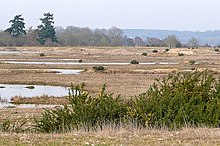
Crookham Commons were designated as public parkland. Cattle from local farms are permitted to graze the Commons and often stray onto the adjacent Burys Bank Road.
498:
287:
The area has been common grazing land for the parishes since Norman times. Besides the grazing of local animals, the commons were used for troop movements during the
404:
182:
258:
The two commons have the largest area of heathland and acid grassland in the county and other habitats are gorse scrub, broadleaved woodland and water-logged
936:
106:
66:
121:
306:
792:
767:
602:
520:
330:
247:
The SSSI is in several areas and it is part of the 444-hectare (1,100-acre) Greenham and
Crookham Commons nature reserve, which is owned by
1078:
847:
204:
42:
378:
1385:
782:
1225:
627:
487:
477:
1380:
1028:
712:
577:
822:
333:, but following the closure of the base in September 1992, it was opened to the public as a nature reserve in April 2000.
318:
1083:
732:
114:
1314:
1205:
797:
617:
607:
1220:
1038:
642:
50:
1355:
1245:
852:
827:
28:
451:
1304:
717:
692:
513:
271:
1408:
1073:
921:
552:
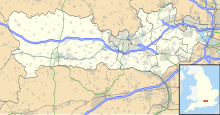
322:
1128:
910:
812:
248:
1365:
429:
1278:
1190:
1154:
900:
632:
592:
582:
1504:
1370:
1146:
885:
842:
506:
329:, also as a base for nuclear weapons. In the 1980s, the commons therefore became the location of the
1547:
1451:
1471:
1286:
1260:
1063:
1058:
895:
702:
310:
300:
1360:
1296:
1108:
1053:
837:
802:
742:
697:
647:
597:
220:
1023:
1018:
662:
562:
1375:
1582:
1489:
1423:
1347:
1240:
1159:
1033:
992:
905:
875:
817:
807:
667:
572:
483:
288:
263:
169:
1519:
1479:
1390:
1195:
1136:
1118:
1103:
1098:
977:
969:
787:
777:
707:
637:
612:
1532:
1494:
1268:
1200:
1173:
890:
314:
722:
1499:
1484:
1413:
1324:
1319:
1182:
1010:
1000:
982:
762:
747:
657:
267:
100:
1566:
1527:
1436:
1235:
1215:
1093:
1048:
772:
682:
652:
557:
1542:
1431:
1230:
880:
857:
757:
752:
737:
727:
587:
567:
208:
1456:
1446:
1338:
1309:
687:
200:
17:
1537:
1509:
1461:
1210:
1113:
1088:
1068:
867:
832:
677:
622:
544:
196:
136:
123:
1441:
960:
531:
228:
326:
216:
212:
1250:
224:
1400:
379:"Drivers urged to slow down and be vigilant for cattle in Greenham"
259:
925:
502:
262:
valleys. There is a rich variety of invertebrates, such as the
432:. Berkshire, Buckinghamshire and Oxfordshire Wildlife Trust
1573:
Berkshire, Buckinghamshire and
Oxfordshire Wildlife Trust
953:
Berkshire, Buckinghamshire and
Oxfordshire Wildlife Trust
253:
Berkshire, Buckinghamshire and
Oxfordshire Wildlife Trust
457:. Sites of Special Scientific Interest. Natural England
407:. Sites of Special Scientific Interest. Natural England
359:. Sites of Special Scientific Interest. Natural England
357:"Designated Sites View: Greenham and Crookham Commons"
482:. Wokingham: Nash Ford Publishing. pp. 125–133.
73:
1518:
1470:
1422:
1399:
1346:
1337:
1295:
1277:
1259:
1181:
1172:
1145:
1127:
1009:
991:
968:
959:
866:
543:
178:
168:
160:
152:
113:
99:
89:
1578:Sites of Special Scientific Interest in Berkshire
537:Sites of Special Scientific Interest in Berkshire
291:and in the eighteen and nineteenth centuries.
937:
514:
8:
36:
1343:
1178:
965:
944:
930:
922:
521:
507:
499:
49:
35:
479:West Berkshire Town and Village Histories
452:"Greenham and Crookham Commons citation"
424:
422:
341:
405:"Map of Greenham and Crookham Commons"
793:Sulham and Tidmarsh Woods and Meadows
768:Sandhurst to Owlsmoor Bogs and Heaths
603:Broadmoor to Bagshot Woods and Heaths
351:
349:
347:
345:
7:
1079:Padworth Common Local Nature Reserve
321:during the Second World War and the
848:Wraysbury and Hythe End Gravel Pits
243:Site of Special Scientific Interest
205:Site of Special Scientific Interest
43:Site of Special Scientific Interest
783:Stanford End Mill and River Loddon
199:areas of 280.5-hectare (693-acre)
25:
628:Combe Wood and Linkenholt Hanging
313:in 1942; it was used by both the
530:
72:
65:
1386:Woodford Bottom and Lamb's Pool
1315:Grangelands and The Rifle Range
430:"Greenham and Crookham Commons"
219:, on the southern outskirts of
713:Kennet and Lambourn Floodplain
578:Bowdown and Chamberhouse Woods
1:
1099:Snelsmore Common Country Park
1044:Greenham and Crookham Commons
838:Windsor Forest and Great Park
673:Greenham and Crookham Commons
319:United States Army Air Forces
193:Greenham and Crookham Commons
37:Greenham and Crookham Commons
1084:Paices Wood Country Parkland
733:Lodge Wood and Sandford Mill
1211:Dancersend with Pavis Woods
798:Swinley Park and Brick Pits
608:Catmore and Winterly Copses
203:designated as a biological
1599:
823:West's Meadow, Aldermaston
643:Decoy Pit, Pools and Woods
298:
164:280.5 hectares (693 acres)
26:
1246:Weston Turville Reservoir
853:Wraysbury No 1 Gravel Pit
828:Westfield Farm Chalk Bank
476:Ford, David Nash (2020).
295:World War II and Cold War
81:Location within Berkshire
60:
48:
41:
29:Crookham (disambiguation)
1226:Hog and Hollowhill Woods
718:Kennet Valley Alderwoods
693:Inkpen and Walbury Hills
272:silver-washed fritillary
1409:CS Lewis Nature Reserve
1074:Nature Discovery Centre
553:Aldermaston Gravel Pits
323:United States Air Force
307:Royal Air Force station
1510:Warburg Nature Reserve
1129:Windsor and Maidenhead
911:Winterbourne Chalk Pit
813:Wellington College Bog
274:woodland butterflies.
249:West Berkshire Council
1381:Whitecross Green Wood
1191:Aston Clinton Ragpits
1155:Loddon Nature Reserve
901:Hamstead Marshall Pit
633:Coombe Wood, Frilsham
593:Bray Pennyroyal Field
583:Boxford Water Meadows
886:Cannoncourt Farm Pit
843:Woolhampton Reed Bed
27:For other uses, see
1472:Vale of White Horse
1366:Hook Norton Cutting
1287:Little Linford Wood
1064:Kintbury Newt Ponds
1059:Inkpen Crocus Field
896:Fognam Chalk Quarry
703:Inkpen Crocus Field
311:RAF Greenham Common
301:RAF Greenham Common
251:and managed by the
133: /
38:
1356:Ardley Wood Quarry
1109:Thatcham Reed Beds
803:Thatcham Reed Beds
743:Old Copse, Beenham
648:Easton Farm Meadow
598:Briff Lane Meadows
385:. 22 December 2017
331:Women's Peace Camp
305:The area became a
195:are two adjoining
1560:
1559:
1556:
1555:
1490:Lashford Lane Fen
1424:South Oxfordshire
1333:
1332:
1241:Upper Ray Meadows
1221:Foxcote Reservoir
1168:
1167:
1160:Shepperlands Farm
1034:Bucklebury Common
919:
918:
876:Boxford Chalk Pit
818:West Woodhay Down
808:Wasing Wood Ponds
668:Great Thrift Wood
573:Blackwater Valley
289:English Civil War
190:
189:
16:(Redirected from
1590:
1520:West Oxfordshire
1480:Dry Sandford Pit
1391:Woodsides Meadow
1344:
1196:Bernwood Meadows
1179:
1137:Hurley Chalk Pit
1119:Wokefield Common
1104:Sole Common Pond
970:Bracknell Forest
966:
946:
939:
932:
923:
788:Streatley Warren
778:Snelsmore Common
708:Irish Hill Copse
613:Chawridge Bourne
535:
534:
523:
516:
509:
500:
494:
493:
473:
467:
466:
464:
462:
456:
448:
442:
441:
439:
437:
426:
417:
416:
414:
412:
401:
395:
394:
392:
390:
383:inyourarea.co.uk
375:
369:
368:
366:
364:
353:
283:Pre-20th century
148:
147:
145:
144:
143:
138:
137:51.376°N 1.282°W
134:
131:
130:
129:
126:
109:
76:
75:
69:
53:
39:
21:
1598:
1597:
1593:
1592:
1591:
1589:
1588:
1587:
1563:
1562:
1561:
1552:
1533:Chimney Meadows
1514:
1505:Tuckmill Meadow
1495:Letcombe Valley
1466:
1418:
1395:
1329:
1291:
1273:
1269:Long Grove Wood
1255:
1201:Calvert Jubilee
1174:Buckinghamshire
1164:
1141:
1123:
1024:Avery's Pightle
1019:Audrey's Meadow
1005:
987:
955:
950:
920:
915:
891:Cold Ash Quarry
862:
663:Freeman's Marsh
563:Avery's Pightle
539:
529:
527:
497:
490:
475:
474:
470:
460:
458:
454:
450:
449:
445:
435:
433:
428:
427:
420:
410:
408:
403:
402:
398:
388:
386:
377:
376:
372:
362:
360:
355:
354:
343:
339:
315:Royal Air Force
303:
297:
285:
280:
245:
237:
141:
139:
135:
132:
127:
124:
122:
120:
119:
105:
85:
84:
83:
82:
79:
78:
77:
56:
55:Crookham Common
32:
23:
22:
18:Crookham Common
15:
12:
11:
5:
1596:
1594:
1586:
1585:
1580:
1575:
1565:
1564:
1558:
1557:
1554:
1553:
1551:
1550:
1548:Westwell Gorse
1545:
1540:
1535:
1530:
1524:
1522:
1516:
1515:
1513:
1512:
1507:
1502:
1500:Parsonage Moor
1497:
1492:
1487:
1485:Hitchcopse Pit
1482:
1476:
1474:
1468:
1467:
1465:
1464:
1459:
1454:
1452:Sydlings Copse
1449:
1444:
1439:
1434:
1428:
1426:
1420:
1419:
1417:
1416:
1414:Iffley Meadows
1411:
1405:
1403:
1397:
1396:
1394:
1393:
1388:
1383:
1378:
1373:
1368:
1363:
1358:
1352:
1350:
1341:
1335:
1334:
1331:
1330:
1328:
1327:
1325:Millfield Wood
1322:
1320:Homefield Wood
1317:
1312:
1307:
1301:
1299:
1293:
1292:
1290:
1289:
1283:
1281:
1275:
1274:
1272:
1271:
1265:
1263:
1257:
1256:
1254:
1253:
1248:
1243:
1238:
1233:
1228:
1223:
1218:
1213:
1208:
1203:
1198:
1193:
1187:
1185:
1183:Aylesbury Vale
1176:
1170:
1169:
1166:
1165:
1163:
1162:
1157:
1151:
1149:
1143:
1142:
1140:
1139:
1133:
1131:
1125:
1124:
1122:
1121:
1116:
1111:
1106:
1101:
1096:
1091:
1086:
1081:
1076:
1071:
1066:
1061:
1056:
1051:
1046:
1041:
1036:
1031:
1026:
1021:
1015:
1013:
1011:West Berkshire
1007:
1006:
1004:
1003:
1001:Haymill Valley
997:
995:
989:
988:
986:
985:
983:Wildmoor Heath
980:
978:Chawridge Bank
974:
972:
963:
957:
956:
951:
949:
948:
941:
934:
926:
917:
916:
914:
913:
908:
906:Pincent's Kiln
903:
898:
893:
888:
883:
878:
872:
870:
864:
863:
861:
860:
855:
850:
845:
840:
835:
830:
825:
820:
815:
810:
805:
800:
795:
790:
785:
780:
775:
770:
765:
763:River Lambourn
760:
755:
750:
748:Park Farm Down
745:
740:
735:
730:
725:
720:
715:
710:
705:
700:
695:
690:
685:
680:
675:
670:
665:
660:
658:Englemere Pond
655:
650:
645:
640:
635:
630:
625:
620:
615:
610:
605:
600:
595:
590:
585:
580:
575:
570:
565:
560:
555:
549:
547:
541:
540:
528:
526:
525:
518:
511:
503:
496:
495:
488:
468:
443:
418:
396:
370:
340:
338:
335:
299:Main article:
296:
293:
284:
281:
279:
276:
268:purple emperor
244:
241:
236:
233:
209:civil parishes
207:(SSSI) in the
188:
187:
180:
176:
175:
172:
166:
165:
162:
158:
157:
154:
150:
149:
142:51.376; -1.282
117:
111:
110:
103:
101:Grid reference
97:
96:
93:
87:
86:
80:
71:
70:
64:
63:
62:
61:
58:
57:
54:
46:
45:
24:
14:
13:
10:
9:
6:
4:
3:
2:
1595:
1584:
1581:
1579:
1576:
1574:
1571:
1570:
1568:
1549:
1546:
1544:
1541:
1539:
1536:
1534:
1531:
1529:
1528:Blenheim Farm
1526:
1525:
1523:
1521:
1517:
1511:
1508:
1506:
1503:
1501:
1498:
1496:
1493:
1491:
1488:
1486:
1483:
1481:
1478:
1477:
1475:
1473:
1469:
1463:
1460:
1458:
1455:
1453:
1450:
1448:
1445:
1443:
1440:
1438:
1437:Cholsey Marsh
1435:
1433:
1430:
1429:
1427:
1425:
1421:
1415:
1412:
1410:
1407:
1406:
1404:
1402:
1398:
1392:
1389:
1387:
1384:
1382:
1379:
1377:
1374:
1372:
1369:
1367:
1364:
1362:
1359:
1357:
1354:
1353:
1351:
1349:
1345:
1342:
1340:
1336:
1326:
1323:
1321:
1318:
1316:
1313:
1311:
1308:
1306:
1303:
1302:
1300:
1298:
1294:
1288:
1285:
1284:
1282:
1280:
1279:Milton Keynes
1276:
1270:
1267:
1266:
1264:
1262:
1258:
1252:
1249:
1247:
1244:
1242:
1239:
1237:
1236:Rushbeds Wood
1234:
1232:
1229:
1227:
1224:
1222:
1219:
1217:
1216:Finemere Wood
1214:
1212:
1209:
1207:
1204:
1202:
1199:
1197:
1194:
1192:
1189:
1188:
1186:
1184:
1180:
1177:
1175:
1171:
1161:
1158:
1156:
1153:
1152:
1150:
1148:
1144:
1138:
1135:
1134:
1132:
1130:
1126:
1120:
1117:
1115:
1112:
1110:
1107:
1105:
1102:
1100:
1097:
1095:
1094:Seven Barrows
1092:
1090:
1087:
1085:
1082:
1080:
1077:
1075:
1072:
1070:
1067:
1065:
1062:
1060:
1057:
1055:
1054:Inkpen Common
1052:
1050:
1049:Hosehill Lake
1047:
1045:
1042:
1040:
1037:
1035:
1032:
1030:
1029:Bowdown Woods
1027:
1025:
1022:
1020:
1017:
1016:
1014:
1012:
1008:
1002:
999:
998:
996:
994:
990:
984:
981:
979:
976:
975:
973:
971:
967:
964:
962:
958:
954:
947:
942:
940:
935:
933:
928:
927:
924:
912:
909:
907:
904:
902:
899:
897:
894:
892:
889:
887:
884:
882:
879:
877:
874:
873:
871:
869:
865:
859:
856:
854:
851:
849:
846:
844:
841:
839:
836:
834:
831:
829:
826:
824:
821:
819:
816:
814:
811:
809:
806:
804:
801:
799:
796:
794:
791:
789:
786:
784:
781:
779:
776:
774:
773:Seven Barrows
771:
769:
766:
764:
761:
759:
756:
754:
751:
749:
746:
744:
741:
739:
736:
734:
731:
729:
726:
724:
721:
719:
716:
714:
711:
709:
706:
704:
701:
699:
698:Inkpen Common
696:
694:
691:
689:
686:
684:
681:
679:
676:
674:
671:
669:
666:
664:
661:
659:
656:
654:
653:Enborne Copse
651:
649:
646:
644:
641:
639:
638:Croker's Hole
636:
634:
631:
629:
626:
624:
621:
619:
616:
614:
611:
609:
606:
604:
601:
599:
596:
594:
591:
589:
586:
584:
581:
579:
576:
574:
571:
569:
566:
564:
561:
559:
558:Ashridge Wood
556:
554:
551:
550:
548:
546:
542:
538:
533:
524:
519:
517:
512:
510:
505:
504:
501:
491:
489:9781905191031
485:
481:
480:
472:
469:
453:
447:
444:
431:
425:
423:
419:
406:
400:
397:
384:
380:
374:
371:
358:
352:
350:
348:
346:
342:
336:
334:
332:
328:
324:
320:
316:
312:
308:
302:
294:
292:
290:
282:
277:
275:
273:
269:
265:
264:white admiral
261:
256:
254:
250:
242:
240:
234:
232:
230:
226:
222:
218:
214:
210:
206:
202:
198:
194:
186:
185:
181:
177:
173:
171:
167:
163:
159:
155:
151:
146:
118:
116:
112:
108:
104:
102:
98:
94:
92:
88:
68:
59:
52:
47:
44:
40:
34:
30:
19:
1543:Glyme Valley
1432:Chinnor Hill
1305:Bacombe Hill
1231:Pilch Fields
1206:College Lake
1043:
881:Brimpton Pit
858:Wykery Copse
758:River Kennet
753:Redhill Wood
738:Longmoor Bog
728:Lardon Chase
723:King's Copse
672:
588:Bray Meadows
568:Bisham Woods
478:
471:
459:. Retrieved
446:
434:. Retrieved
409:. Retrieved
399:
387:. Retrieved
382:
373:
361:. Retrieved
304:
286:
257:
246:
238:
192:
191:
183:
179:Location map
170:Notification
33:
1457:Warren Bank
1447:Oakley Hill
1371:Lamb's Pool
1361:Asham Meads
1339:Oxfordshire
1310:Gomm Valley
1039:Decoy Heath
833:White Shute
688:Holies Down
618:Cleeve Hill
325:during the
235:Public park
201:common land
197:public park
140: /
115:Coordinates
1567:Categories
1462:Wells Farm
1114:Watts Bank
1089:Rack Marsh
1069:Moor Copse
868:Geological
683:Hog's Hole
678:Heath Lake
623:Cock Marsh
545:Biological
461:15 October
436:15 October
411:15 October
363:15 October
337:References
227:county of
156:Biological
125:51°22′34″N
107:SU 501 644
1442:Hartslock
1376:Oxey Mead
1147:Wokingham
961:Berkshire
389:6 October
229:Berkshire
184:Magic Map
128:1°16′55″W
95:Berkshire
1583:Thatcham
1538:Foxholes
1348:Cherwell
1261:Chiltern
327:Cold War
217:Thatcham
213:Greenham
153:Interest
91:Location
1297:Wycombe
1251:Yoesden
309:called
278:History
225:English
223:in the
221:Newbury
1401:Oxford
993:Slough
486:
455:(PDF)
260:alder
484:ISBN
463:2019
438:2019
413:2019
391:2020
365:2019
317:and
270:and
215:and
174:1994
161:Area
211:of
1569::
421:^
381:.
344:^
266:,
255:.
231:.
945:e
938:t
931:v
522:e
515:t
508:v
492:.
465:.
440:.
415:.
393:.
367:.
31:.
20:)
Text is available under the Creative Commons Attribution-ShareAlike License. Additional terms may apply.