33:
226:
1272:
1234:
1246:
40:
989:
1316:
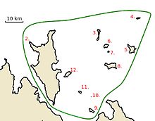
217:, which has an area of 331 km. Croker Island is also the only permanently inhabited island in the group. None of the other islands in the group is larger than 15 km.
32:
982:
1340:
911:
1335:
1238:
975:
1250:
943:
1309:
789:
1123:
740:
593:
838:
297:
691:
446:
213:
The group consists of at least 12 named islands, and a number of small unnamed islands and rocks. By far the largest island of the group is
1145:
1039:
436:
346:
1302:
642:
544:
1103:
495:
395:
1202:
1088:
81:
1172:
1155:
886:
1150:
1108:
1113:
918:
149:
1130:
1135:
207:
225:
176:
1279:
1182:
200:
171:
1197:
1068:
1046:
1022:
1017:
196:
1286:
166:
1118:
1073:
1061:
1051:
891:
1207:
1187:
1214:
1167:
1162:
1098:
1056:
1329:
1219:
1177:
1093:
1083:
1078:
1034:
1012:
1007:
287:
214:
967:
957:
1271:
1192:
1140:
204:
192:
69:
854:
840:
805:
791:
756:
742:
707:
693:
658:
644:
609:
595:
560:
546:
511:
497:
462:
448:
411:
397:
362:
348:
313:
299:
96:
83:
1282:
161:
892:
NT Place Names
Register, McCluer Island named after Captain John McCluer
912:"Northern Territory Government: Sites of Conservation Significance"
229:
Location Map of Croker Island Group, Northern
Territory, Australia
224:
203:
of
Australia. The group is Aboriginal freehold land, held by the
971:
1290:
134:
126:
112:
75:
65:
60:
52:New Year Island (Northern Territory, Australia)
1310:
983:
8:
21:
1317:
1303:
990:
976:
968:
20:
272:
16:Islands in Northern Territory, Australia
903:
7:
1268:
1266:
1245:
39:
1341:Northern Territory geography stubs
1289:. You can help Knowledge (XXG) by
14:
1336:Islands of the Northern Territory
998:Islands of the Northern Territory
1270:
1244:
1233:
1232:
38:
31:
195:. The group lies offshore from
1:
191:is a group of islands in the
887:List of islands of Australia
177:GPX (secondary coordinates)
1357:
1265:
1228:
1003:
172:GPX (primary coordinates)
147:Map all coordinates using
117:
26:
958:"Bonzle: McCluer Island"
944:"Bonzle: Peacock Island"
155:Download coordinates as:
1131:Sir George Hope Islands
855:11.19519°S 132.662578°E
806:11.28927°S 132.727976°E
757:11.31669°S 132.78366°E
270:
860:-11.19519; 132.662578
811:-11.28927; 132.727976
314:11.1333331°S 132.55°E
228:
208:Aboriginal Land Trust
199:, and is part of the
167:GPX (all coordinates)
762:-11.31669; 132.78366
610:11.0823°S 132.8775°E
850: /
801: /
752: /
703: /
654: /
605: /
556: /
507: /
458: /
407: /
358: /
319:-11.1333331; 132.55
309: /
93: /
23:
1280:Northern Territory
924:on 12 January 2017
708:11.383°S 132.785°E
615:-11.0823; 132.8775
463:10.908°S 133.031°E
363:11.025°S 132.458°E
271:
201:Northern Territory
130:Northern Territory
1298:
1297:
1260:
1259:
1104:Sir Edward Pellew
878:
877:
659:11.156°S 132.89°E
412:11.00°S 132.826°E
197:Cobourg Peninsula
142:
141:
1348:
1319:
1312:
1305:
1274:
1267:
1248:
1247:
1236:
1235:
992:
985:
978:
969:
962:
961:
954:
948:
947:
940:
934:
933:
931:
929:
923:
917:. Archived from
916:
908:
874:
873:
871:
870:
869:
867:
862:
861:
856:
851:
848:
847:
846:
843:
825:
824:
822:
821:
820:
818:
813:
812:
807:
802:
799:
798:
797:
794:
776:
775:
773:
772:
771:
769:
764:
763:
758:
753:
750:
749:
748:
745:
727:
726:
724:
723:
722:
720:
715:
714:
713:-11.383; 132.785
709:
704:
701:
700:
699:
696:
678:
677:
675:
674:
673:
671:
666:
665:
660:
655:
652:
651:
650:
647:
629:
628:
626:
625:
624:
622:
621:Delphinia Island
617:
616:
611:
606:
603:
602:
601:
598:
585:Delphinia Island
580:
579:
577:
576:
575:
573:
568:
567:
562:
561:11.05°S 132.86°E
557:
554:
553:
552:
549:
531:
530:
528:
527:
526:
524:
519:
518:
513:
508:
505:
504:
503:
500:
482:
481:
479:
478:
477:
475:
470:
469:
468:-10.908; 133.031
464:
459:
456:
455:
454:
451:
431:
430:
428:
427:
426:
424:
419:
418:
413:
408:
405:
404:
403:
400:
382:
381:
379:
378:
377:
375:
370:
369:
368:-11.025; 132.458
364:
359:
356:
355:
354:
351:
333:
332:
330:
329:
328:
326:
321:
320:
315:
310:
307:
306:
305:
302:
273:
251:Delphinia Island
108:
107:
105:
104:
103:
98:
94:
91:
90:
89:
86:
42:
41:
35:
24:
1356:
1355:
1351:
1350:
1349:
1347:
1346:
1345:
1326:
1325:
1324:
1323:
1263:
1261:
1256:
1224:
999:
996:
966:
965:
956:
955:
951:
942:
941:
937:
927:
925:
921:
914:
910:
909:
905:
900:
883:
865:
863:
859:
857:
853:
852:
849:
844:
841:
839:
837:
836:
816:
814:
810:
808:
804:
803:
800:
795:
792:
790:
788:
787:
767:
765:
761:
759:
755:
754:
751:
746:
743:
741:
739:
738:
719:Valencia Island
718:
716:
712:
710:
706:
705:
702:
697:
694:
692:
690:
689:
683:Valencia Island
669:
667:
664:-11.156; 132.89
663:
661:
657:
656:
653:
648:
645:
643:
641:
640:
620:
618:
614:
612:
608:
607:
604:
599:
596:
594:
592:
591:
571:
569:
565:
563:
559:
558:
555:
550:
547:
545:
543:
542:
522:
520:
516:
514:
512:11.07°S 133.0°E
510:
509:
506:
501:
498:
496:
494:
493:
474:New Year Island
473:
471:
467:
465:
461:
460:
457:
452:
449:
447:
445:
444:
437:New Year Island
422:
420:
417:-11.00; 132.826
416:
414:
410:
409:
406:
401:
398:
396:
394:
393:
373:
371:
367:
365:
361:
360:
357:
352:
349:
347:
345:
344:
324:
322:
318:
316:
312:
311:
308:
303:
300:
298:
296:
295:
269:
257:Valencia Island
242:New Year Island
223:
221:List of Islands
185:
184:
183:
182:
181:
122:
101:
99:
95:
92:
87:
84:
82:
80:
79:
56:
55:
54:
53:
50:
49:
48:
47:
43:
17:
12:
11:
5:
1354:
1352:
1344:
1343:
1338:
1328:
1327:
1322:
1321:
1314:
1307:
1299:
1296:
1295:
1275:
1258:
1257:
1255:
1254:
1242:
1229:
1226:
1225:
1223:
1222:
1217:
1215:Vernon Islands
1212:
1211:
1210:
1205:
1200:
1195:
1190:
1185:
1180:
1175:
1165:
1160:
1159:
1158:
1153:
1148:
1138:
1136:Three Hummocks
1133:
1128:
1127:
1126:
1121:
1116:
1111:
1101:
1096:
1091:
1086:
1081:
1076:
1071:
1066:
1065:
1064:
1057:Groote Eylandt
1054:
1049:
1044:
1043:
1042:
1037:
1027:
1026:
1025:
1015:
1010:
1004:
1001:
1000:
997:
995:
994:
987:
980:
972:
964:
963:
949:
935:
902:
901:
899:
896:
895:
894:
889:
882:
879:
876:
875:
834:
831:
827:
826:
817:Templer Island
785:
782:
781:Templer Island
778:
777:
768:Cowlard Island
736:
733:
732:Cowlard Island
729:
728:
687:
684:
680:
679:
638:
635:
631:
630:
589:
586:
582:
581:
566:-11.05; 132.86
540:
537:
533:
532:
523:McCluer Island
491:
488:
487:McCluer Island
484:
483:
442:
439:
433:
432:
391:
388:
384:
383:
374:Peacock Island
342:
339:
338:Peacock Island
335:
334:
293:
290:
284:
283:
280:
277:
268:
267:
264:
263:Templer Island
261:
260:Cowlard Island
258:
255:
252:
249:
246:
245:McCluer Island
243:
240:
237:
236:Peacock Island
234:
230:
222:
219:
180:
179:
174:
169:
164:
158:
152:
145:
144:
143:
140:
139:
136:
132:
131:
128:
124:
123:
118:
115:
114:
113:Administration
110:
109:
97:11.1°S 132.7°E
77:
73:
72:
67:
63:
62:
58:
57:
51:
45:
44:
37:
36:
30:
29:
28:
27:
15:
13:
10:
9:
6:
4:
3:
2:
1353:
1342:
1339:
1337:
1334:
1333:
1331:
1320:
1315:
1313:
1308:
1306:
1301:
1300:
1294:
1292:
1288:
1285:article is a
1284:
1281:
1276:
1273:
1269:
1264:
1253:
1252:
1243:
1241:
1240:
1231:
1230:
1227:
1221:
1218:
1216:
1213:
1209:
1206:
1204:
1201:
1199:
1196:
1194:
1191:
1189:
1186:
1184:
1181:
1179:
1176:
1174:
1171:
1170:
1169:
1166:
1164:
1161:
1157:
1154:
1152:
1149:
1147:
1144:
1143:
1142:
1139:
1137:
1134:
1132:
1129:
1125:
1122:
1120:
1117:
1115:
1112:
1110:
1107:
1106:
1105:
1102:
1100:
1097:
1095:
1092:
1090:
1087:
1085:
1082:
1080:
1077:
1075:
1072:
1070:
1067:
1063:
1060:
1059:
1058:
1055:
1053:
1050:
1048:
1045:
1041:
1038:
1036:
1033:
1032:
1031:
1028:
1024:
1021:
1020:
1019:
1016:
1014:
1011:
1009:
1006:
1005:
1002:
993:
988:
986:
981:
979:
974:
973:
970:
959:
953:
950:
945:
939:
936:
920:
913:
907:
904:
897:
893:
890:
888:
885:
884:
880:
872:
835:
832:
829:
828:
823:
786:
783:
780:
779:
774:
737:
734:
731:
730:
725:
688:
685:
682:
681:
676:
639:
636:
633:
632:
627:
590:
587:
584:
583:
578:
572:Lawson Island
541:
538:
536:Lawson Island
535:
534:
529:
517:-11.07; 133.0
492:
489:
486:
485:
480:
443:
440:
438:
435:
434:
429:
392:
389:
386:
385:
380:
343:
340:
337:
336:
331:
325:Croker Island
294:
291:
289:
288:Croker Island
286:
285:
281:
278:
275:
274:
265:
262:
259:
256:
253:
250:
248:Lawson Island
247:
244:
241:
238:
235:
233:Croker Island
232:
231:
227:
220:
218:
216:
215:Croker Island
211:
209:
206:
202:
198:
194:
190:
178:
175:
173:
170:
168:
165:
163:
160:
159:
157:
156:
151:
150:OpenStreetMap
148:
137:
133:
129:
125:
121:
116:
111:
106:
78:
74:
71:
68:
64:
59:
34:
25:
19:
1291:expanding it
1277:
1262:
1249:
1237:
1030:Croker Group
1029:
952:
938:
926:. Retrieved
919:the original
906:
866:Darch Island
830:Darch Island
735:0.02 km
670:Grant Island
634:Grant Island
423:Oxley Island
387:Oxley Island
341:0.09 km
266:Darch Island
254:Grant Island
239:Oxley Island
212:
189:Croker Group
188:
186:
154:
153:
146:
119:
102:-11.1; 132.7
46:Croker Group
22:Croker Group
18:
1124:South West
858: /
845:132°39′45″E
809: /
796:132°43′41″E
760: /
747:132°47′01″E
711: /
698:132°47′06″E
662: /
649:132°53′24″E
613: /
600:132°52′39″E
588:0.6 km
564: /
515: /
466: /
453:133°01′52″E
415: /
402:132°49′34″E
366: /
353:132°27′29″E
317: /
304:132°33′00″E
292:331 km
205:Arnhem Land
193:Arafura Sea
100: /
76:Coordinates
70:Arafura Sea
1330:Categories
1198:Marchinbar
1183:Cunningham
1069:Haul Round
1047:East Woody
1023:Milingimbi
898:References
864: (
842:11°11′43″S
815: (
793:11°17′21″S
766: (
744:11°19′00″S
717: (
695:11°22′59″S
668: (
646:11°09′22″S
637:12 km
619: (
597:11°04′56″S
570: (
521: (
490:9 km
472: (
450:10°54′29″S
421: (
399:11°00′00″S
372: (
350:11°01′30″S
323: (
301:11°08′00″S
1283:geography
1119:Vanderlin
1074:Higginson
1062:Bickerton
1040:New Year
1018:Crocodile
833:6 km
784:1 km
686:3 km
539:3 km
441:1 km
390:2 km
282:Location
120:Australia
61:Geography
1239:Category
1208:Raragala
1188:Drysdale
1151:Melville
1146:Bathurst
1052:Goulburn
881:See also
551:132°52′E
502:133°00′E
88:132°42′E
66:Location
1251:Commons
1163:Warnawi
1156:Seagull
1099:Rimbija
548:11°03′S
499:11°04′S
138:Top End
85:11°06′S
1220:Woodah
1203:Quail
1178:Bumaga
1173:Abbott
1168:Wessel
1114:Skull
1109:Centre
1084:Inglis
1079:Howard
1035:Croker
1013:Burney
1008:Bremer
928:23 May
135:Region
1278:This
1193:Elcho
1094:Peron
1089:Maria
922:(PDF)
915:(PDF)
127:State
1287:stub
1141:Tiwi
930:2016
279:Area
276:Name
187:The
162:KML
1332::
210:.
1318:e
1311:t
1304:v
1293:.
991:e
984:t
977:v
960:.
946:.
932:.
868:)
819:)
770:)
721:)
672:)
623:)
574:)
525:)
476:)
425:)
376:)
327:)
Text is available under the Creative Commons Attribution-ShareAlike License. Additional terms may apply.