422:
410:
398:
116:
46:
434:
68:
84:
625:
123:
91:
359:. Until the 18th century its name was Langenweyer. First settlements in that area were formed in the 9th century before Christ, with continuous settlements existing since the 2nd century after Christ. The name Holthausen was mentioned first time about 1700. Until the beginning of the industrial revolution, Holthausen was a small village. It changed after the
363:
Company opened its headquarters in
Holthausen. In 1823 Holthausen had 322 inhabitants; in 1869 – 384; in 1895 – 556 people lived in Holthausen; 1905 – 1,884 people. Holthausen's population was at its largest in 1969 – 15,000 inhabitants. Around 12,000 people live there today.
935:
529:
377:
There are two underground lines (U74 and U77), two tram lines (701 and 713) as well as the bus lines (724, 789, 817, 835 and NE7) in
Holthausen. Holthausen is connected to the
115:
150:
421:
409:
433:
397:
522:
461:
486:
83:
515:
624:
700:
308:
45:
370:
Holthausen still has some important industrial head offices today, as Henkel is still in
Holthausen, right next to the
743:
613:
209:
606:
599:
592:
585:
578:
571:
564:
557:
550:
538:
345:
325:
229:
60:
817:
748:
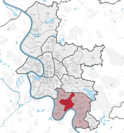
664:
639:
850:
644:
333:
329:
197:
67:
287:
863:
337:
906:
297:
204:
883:
840:
705:
341:
799:
710:
356:
381:
192:
367:
From 1909 to 1929 Holthausen was a part of
Benrath and in 1929 it became part of Düsseldorf.
355:
Holthausen's history is connected to the history of Itter, Himmelgeist, Benrath, Wersten and
278:
794:
391:
In the south of
Holthausen there is a great forest area, the Heyepark and a sports park.
385:
352:. It has an area of 5.35 km (2.07 sq mi), and 12,775 inhabitants (2020).
378:
929:
789:
321:
219:
36:
761:
725:
672:
873:
855:
845:
822:
812:
659:
304:
283:
165:
152:
911:
893:
832:
827:
804:
756:
720:
649:
32:
738:
888:
781:
771:
715:
682:
677:
654:
507:
898:
868:
776:
185:
766:
733:
371:
360:
695:
462:"Stadtgebietsprofile - Stadtbezirke und Stadtteile 05 Bevölkerung"
349:
690:
487:"Stadtgebietsprofile - Stadtbezirke und Stadtteile 03 Geografie"
511:
16:
Stadtteil of Düsseldorf in North Rhine-Westphalia, Germany
294:
277:
269:
261:
256:
248:
243:
235:
225:
215:
203:
191:
181:
21:
523:
122:
90:
8:
936:Urban districts and boroughs of Düsseldorf
530:
516:
508:
18:
439:Tram U71 at Düsseldorf Niederheid station
384:(Neuss - Düsseldorf - Wuppertal) and the
456:
454:
450:
393:
276:
255:
242:
234:
180:
145:
75:
51:
42:
293:
268:
260:
247:
224:
214:
202:
190:
7:
252:5.35 km (2.07 sq mi)
137:Show map of North Rhine-Westphalia
14:
623:
432:
420:
408:
396:
348:. A natural border is the river
121:
114:
89:
82:
66:
44:
427:Klarenbach Church (Protestant)
1:
492:. Landeshauptstadt Düsseldorf
467:. Landeshauptstadt Düsseldorf
273:2,400/km (6,200/sq mi)
55:Map of Düsseldorf, showing
952:
632:
621:
545:
328:. It is located south of
146:
76:
52:
43:
30:
320:is an urban quarter of
539:Boroughs of Düsseldorf
198:North Rhine-Westphalia
130:Düsseldorf-Holthausen
98:Düsseldorf-Holthausen
24:Düsseldorf-Holthausen
415:St Laurentius (Cath.)
296: • Summer (
388:B 8 goes across it.
270: • Density
166:51.17194°N 6.83167°E
162: /
105:Show map of Germany
262: • Total
249: • Total
920:
919:
403:St Joseph (Cath.)
315:
314:
171:51.17194; 6.83167
943:
627:
532:
525:
518:
509:
502:
501:
499:
497:
491:
483:
477:
476:
474:
472:
466:
458:
436:
424:
412:
400:
301:
177:
176:
174:
173:
172:
167:
163:
160:
159:
158:
155:
138:
131:
125:
124:
118:
106:
99:
93:
92:
86:
70:
59:(in red) within
48:
25:
19:
951:
950:
946:
945:
944:
942:
941:
940:
926:
925:
923:
921:
916:
628:
619:
541:
536:
506:
505:
495:
493:
489:
485:
484:
480:
470:
468:
464:
460:
459:
452:
447:
440:
437:
428:
425:
416:
413:
404:
401:
379:federal highway
295:
170:
168:
164:
161:
156:
153:
151:
149:
148:
142:
141:
140:
139:
136:
135:
134:
133:
132:
129:
126:
109:
108:
107:
104:
103:
102:
101:
100:
97:
94:
72:
71:
64:
39:
26:
23:
17:
12:
11:
5:
949:
947:
939:
938:
928:
927:
918:
917:
915:
914:
909:
904:
901:
896:
891:
886:
881:
876:
871:
866:
861:
858:
853:
848:
843:
838:
835:
830:
825:
820:
815:
810:
807:
802:
797:
792:
787:
784:
779:
774:
769:
764:
759:
754:
751:
746:
741:
736:
731:
728:
723:
718:
713:
708:
703:
701:Friedrichstadt
698:
693:
688:
685:
680:
675:
670:
667:
662:
657:
652:
647:
642:
637:
633:
630:
629:
622:
620:
618:
617:
610:
603:
596:
589:
582:
575:
568:
561:
554:
546:
543:
542:
537:
535:
534:
527:
520:
512:
504:
503:
478:
449:
448:
446:
443:
442:
441:
438:
431:
429:
426:
419:
417:
414:
407:
405:
402:
395:
313:
312:
302:
292:
291:
281:
275:
274:
271:
267:
266:
263:
259:
258:
254:
253:
250:
246:
245:
241:
240:
237:
233:
232:
227:
223:
222:
217:
213:
212:
210:Urban district
207:
201:
200:
195:
189:
188:
183:
179:
178:
144:
143:
128:
127:
120:
119:
113:
112:
111:
110:
96:
95:
88:
87:
81:
80:
79:
78:
77:
74:
73:
65:
54:
53:
50:
49:
41:
40:
31:
28:
27:
22:
15:
13:
10:
9:
6:
4:
3:
2:
948:
937:
934:
933:
931:
924:
913:
910:
908:
905:
902:
900:
897:
895:
892:
890:
887:
885:
882:
880:
877:
875:
872:
870:
867:
865:
862:
859:
857:
854:
852:
849:
847:
844:
842:
839:
836:
834:
831:
829:
826:
824:
821:
819:
816:
814:
811:
808:
806:
803:
801:
798:
796:
793:
791:
790:Lichtenbroich
788:
785:
783:
780:
778:
775:
773:
770:
768:
765:
763:
760:
758:
755:
752:
750:
747:
745:
742:
740:
737:
735:
732:
729:
727:
724:
722:
719:
717:
714:
712:
709:
707:
704:
702:
699:
697:
694:
692:
689:
686:
684:
681:
679:
678:Flingern-Nord
676:
674:
671:
668:
666:
663:
661:
658:
656:
653:
651:
648:
646:
643:
641:
638:
635:
634:
631:
626:
616:
615:
611:
609:
608:
604:
602:
601:
597:
595:
594:
590:
588:
587:
583:
581:
580:
576:
574:
573:
569:
567:
566:
562:
560:
559:
555:
553:
552:
548:
547:
544:
540:
533:
528:
526:
521:
519:
514:
513:
510:
488:
482:
479:
463:
457:
455:
451:
444:
435:
430:
423:
418:
411:
406:
399:
394:
392:
389:
387:
383:
380:
375:
373:
368:
365:
362:
358:
353:
351:
347:
343:
339:
335:
331:
327:
323:
319:
310:
306:
303:
299:
289:
285:
282:
280:
272:
264:
251:
238:
231:
228:
221:
218:
211:
208:
206:
199:
196:
194:
187:
184:
175:
147:Coordinates:
117:
85:
69:
62:
58:
47:
38:
34:
29:
20:
922:
878:
795:Mörsenbroich
762:Kaiserswerth
744:Niederkassel
726:Volmerswerth
683:Flingern-Süd
612:
605:
598:
591:
584:
577:
570:
563:
556:
549:
494:. Retrieved
481:
469:. Retrieved
390:
386:federal road
376:
369:
366:
354:
340:and east of
317:
316:
56:
874:Himmelgeist
346:Himmelgeist
336:, north of
220:Düsseldorf
169: /
37:Düsseldorf
903:Borough 10
879:Holthausen
856:Vennhausen
846:Lierenfeld
823:Hubbelrath
818:Grafenberg
813:Gerresheim
749:Oberkassel
665:Stadtmitte
660:Pempelfort
614:Borough 10
496:4 November
471:4 November
445:References
374:Group HQ.
332:, west of
324:, part of
322:Düsseldorf
318:Holthausen
257:Population
154:51°10′19″N
57:Holthausen
912:Hellerhof
894:Urdenbach
860:Borough 9
851:Unterbach
837:Borough 8
833:Ludenberg
828:Knittkuhl
809:Borough 7
805:Unterrath
786:Borough 6
757:Angermund
753:Borough 5
730:Borough 4
721:Unterbilk
687:Borough 3
673:Düsseltal
669:Borough 2
650:Derendorf
645:Carlstadt
636:Borough 1
607:Borough 9
600:Borough 8
593:Borough 7
586:Borough 6
579:Borough 5
572:Borough 4
565:Borough 3
558:Borough 2
551:Borough 1
326:Borough 9
305:UTC+02:00
284:UTC+01:00
279:Time zone
230:Borough 9
157:6°49′54″E
63:(in pink)
61:Borough 9
33:Stadtteil
930:Category
889:Reisholz
782:Wittlaer
772:Lohausen
716:Oberbilk
655:Golzheim
640:Altstadt
334:Reisholz
330:Oberbilk
205:District
899:Wersten
869:Hassels
864:Benrath
777:Stockum
338:Benrath
236:Founded
226:Borough
186:Germany
182:Country
907:Garath
767:Kalkum
739:Lörick
734:Heerdt
372:Cognis
361:Henkel
265:12,775
884:Itter
841:Eller
706:Hafen
696:Flehe
490:(PDF)
465:(PDF)
350:Rhine
342:Itter
193:State
800:Rath
711:Hamm
691:Bilk
498:2022
473:2022
382:A 46
357:Bilk
344:and
309:CEST
244:Area
239:1700
216:City
298:DST
288:CET
35:of
932::
453:^
531:e
524:t
517:v
500:.
475:.
311:)
307:(
300:)
290:)
286:(
Text is available under the Creative Commons Attribution-ShareAlike License. Additional terms may apply.