65:
866:
90:
218:. It was created in 1925 as a bequest from Brockton businessman Daniel W. Field. Its landscape is dominated by a chain of seven water bodies, all but one of which are man-made, impounding Beaver Brook. The oldest of them, Cross Pond, was created in the 1790s; these lakes, ponds, and reservoirs, were, with one exception, created before the park was laid out, and served either agricultural or industrial purposes. Waldo Lake was created in the 1930s as part of the park's design.
48:
222:
878:
410:
855:
97:
72:
233:
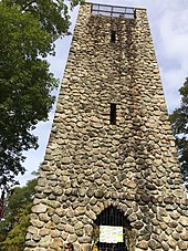
The park's most prominent landmark is a fieldstone observation tower, built at the park's high point, known as Indian Cave Hill or Tower Hill. It was built in 1928 from fieldstones gathered from the park grounds. Inside 90 steps, approximately 18 per landing, lead to an observation deck with a visage
229:
Access to the park's interior is via a narrow road 6 miles (9.7 km) long that winds through the grounds, providing access to its major features. This circuit road is accessible from the surrounding public roadways at a number of points, with gates built from locally gathered fieldstone. There
237:
At the foot of Tower Hill is a concrete pad, in which are embedded Daniel Field's handprints and footprints, and the inscription "Please Enjoy, Do Not
Destroy D.W. Field Park." The other major structure in the park is the gatehouse of the Brockton Reservoir, which was built in the 1880s. The park
493:
801:
796:
791:
424:
489:
469:
464:
459:
429:
903:
479:
449:
351:
254:
908:
484:
474:
454:
434:
259:
823:
444:
439:
828:
776:
656:
610:
543:
706:
681:
641:
569:
538:
517:
786:
722:
691:
646:
631:
626:
781:
686:
676:
579:
696:
671:
661:
636:
589:
574:
564:
548:
522:
732:
727:
701:
666:
651:
594:
584:
344:
758:
753:
230:
is no formalized network of pedestrian paths. As a result, activities tend to be concentrated at the places where there are parking facilities, resulting in some environmental and scenic degradation.
858:
360:
337:
748:
234:
as far as Blue Hills in all directions. The park is open everyday dawn til dusk; the tower is officially open 1 day a year during
Towerfest, early October, Columbus Day weekend.
833:
399:
389:
928:
913:
918:
838:
870:
923:
64:
384:
133:
89:
287:
242:
34:
214:. The park consists of 650 acres (260 ha) of fields, woodlands, and water bodies in northern Brockton and southern
329:
211:
121:
379:
394:
374:
292:
882:
215:
117:
221:
47:
187:
897:
255:
National
Register of Historic Places listings in Plymouth County, Massachusetts
260:
National
Register of Historic Places listings in Norfolk County, Massachusetts
311:
148:
135:
409:
904:
National
Register of Historic Places in Plymouth County, Massachusetts
909:
National
Register of Historic Places in Norfolk County, Massachusetts
220:
282:
207:
333:
361:
U.S. National
Register of Historic Places in Massachusetts
816:
769:
741:
715:
619:
603:
557:
531:
510:
503:
417:
390:
History of the
National Register of Historic Places
367:
193:
180:
172:
164:
127:
113:
871:National Register of Historic Places portal
210:managed by the parks department of the city of
225:DW Field Park tower side view on Towerfest Day
345:
8:
238:also includes an eighteen-hole golf course.
507:
352:
338:
330:
46:
35:U.S. National Register of Historic Places
929:Golf clubs and courses in Massachusetts
914:Parks in Plymouth County, Massachusetts
271:
96:
71:
919:Parks in Norfolk County, Massachusetts
306:
304:
302:
283:"National Register Information System"
277:
275:
18:
312:"NRHP nomination for D.W. Field Park"
7:
288:National Register of Historic Places
243:National Register of Historic Places
176:Negus and Punchard; Field, Daniel W.
14:
924:Sports in Brockton, Massachusetts
876:
864:
854:
853:
408:
95:
88:
70:
63:
314:. Commonwealth of Massachusetts
182:
1:
104:Show map of the United States
16:United States historic place
834:National Historic Landmarks
241:The park was listed on the
945:
829:Cape Cod National Seashore
849:
406:
181:NRHP reference
79:Show map of Massachusetts
57:
45:
41:
32:
25:
21:
883:United States portal
212:Brockton, Massachusetts
168:650 acres (260 ha)
122:Brockton, Massachusetts
380:Keeper of the Register
226:
395:National Park Service
375:Contributing property
293:National Park Service
224:
149:42.10472°N 71.04639°W
216:Avon, Massachusetts
154:42.10472; -71.04639
145: /
227:
891:
890:
812:
811:
511:Barnstable County
385:Historic district
295:. April 15, 2008.
201:
200:
197:November 24, 2000
52:Upper Porter Pond
936:
881:
880:
879:
869:
868:
867:
857:
856:
770:Worcester County
620:Middlesex County
508:
412:
354:
347:
340:
331:
324:
323:
321:
319:
308:
297:
296:
279:
184:
160:
159:
157:
156:
155:
150:
146:
143:
142:
141:
138:
105:
99:
98:
92:
80:
74:
73:
67:
50:
27:D. W. Field Park
19:
944:
943:
939:
938:
937:
935:
934:
933:
894:
893:
892:
887:
877:
875:
865:
863:
845:
808:
765:
737:
711:
615:
599:
553:
527:
499:
418:Lists by county
413:
404:
363:
358:
328:
327:
317:
315:
310:
309:
300:
281:
280:
273:
268:
251:
206:is a municipal
204:D.W. Field Park
153:
151:
147:
144:
139:
136:
134:
132:
131:
109:
108:
107:
106:
103:
102:
101:
100:
83:
82:
81:
78:
77:
76:
75:
53:
37:
28:
17:
12:
11:
5:
942:
940:
932:
931:
926:
921:
916:
911:
906:
896:
895:
889:
888:
886:
885:
873:
861:
850:
847:
846:
844:
843:
842:
841:
831:
826:
820:
818:
814:
813:
810:
809:
807:
806:
805:
804:
799:
794:
784:
779:
773:
771:
767:
766:
764:
763:
762:
761:
756:
745:
743:
742:Suffolk County
739:
738:
736:
735:
730:
725:
719:
717:
716:Norfolk County
713:
712:
710:
709:
704:
699:
694:
689:
684:
679:
674:
669:
664:
659:
654:
649:
644:
639:
634:
629:
623:
621:
617:
616:
614:
613:
607:
605:
604:Hampden County
601:
600:
598:
597:
592:
587:
582:
577:
572:
567:
561:
559:
555:
554:
552:
551:
546:
541:
535:
533:
532:Bristol County
529:
528:
526:
525:
520:
514:
512:
505:
501:
500:
498:
497:
487:
482:
477:
472:
467:
462:
457:
452:
447:
442:
437:
432:
427:
421:
419:
415:
414:
407:
405:
403:
402:
400:Property types
397:
392:
387:
382:
377:
371:
369:
365:
364:
359:
357:
356:
349:
342:
334:
326:
325:
298:
270:
269:
267:
264:
263:
262:
257:
250:
247:
199:
198:
195:
191:
190:
185:
178:
177:
174:
170:
169:
166:
162:
161:
129:
125:
124:
115:
111:
110:
94:
93:
87:
86:
85:
84:
69:
68:
62:
61:
60:
59:
58:
55:
54:
51:
43:
42:
39:
38:
33:
30:
29:
26:
23:
22:
15:
13:
10:
9:
6:
4:
3:
2:
941:
930:
927:
925:
922:
920:
917:
915:
912:
910:
907:
905:
902:
901:
899:
884:
874:
872:
862:
860:
852:
851:
848:
840:
837:
836:
835:
832:
830:
827:
825:
822:
821:
819:
815:
803:
800:
798:
795:
793:
790:
789:
788:
785:
783:
780:
778:
775:
774:
772:
768:
760:
757:
755:
752:
751:
750:
747:
746:
744:
740:
734:
731:
729:
726:
724:
721:
720:
718:
714:
708:
705:
703:
700:
698:
695:
693:
690:
688:
685:
683:
680:
678:
675:
673:
670:
668:
665:
663:
660:
658:
655:
653:
650:
648:
645:
643:
640:
638:
635:
633:
630:
628:
625:
624:
622:
618:
612:
609:
608:
606:
602:
596:
593:
591:
588:
586:
583:
581:
578:
576:
573:
571:
568:
566:
563:
562:
560:
556:
550:
547:
545:
542:
540:
537:
536:
534:
530:
524:
521:
519:
516:
515:
513:
509:
506:
504:Lists by city
502:
495:
491:
488:
486:
483:
481:
478:
476:
473:
471:
468:
466:
463:
461:
458:
456:
453:
451:
448:
446:
443:
441:
438:
436:
433:
431:
428:
426:
423:
422:
420:
416:
411:
401:
398:
396:
393:
391:
388:
386:
383:
381:
378:
376:
373:
372:
370:
366:
362:
355:
350:
348:
343:
341:
336:
335:
332:
313:
307:
305:
303:
299:
294:
290:
289:
284:
278:
276:
272:
265:
261:
258:
256:
253:
252:
248:
246:
244:
239:
235:
231:
223:
219:
217:
213:
209:
205:
196:
194:Added to NRHP
192:
189:
186:
179:
175:
171:
167:
163:
158:
130:
126:
123:
119:
116:
112:
91:
66:
56:
49:
44:
40:
36:
31:
24:
20:
802:southwestern
797:northwestern
558:Essex County
316:. Retrieved
286:
240:
236:
232:
228:
203:
202:
817:Other lists
777:Southbridge
657:Marlborough
611:Springfield
544:New Bedford
152: /
128:Coordinates
898:Categories
707:Winchester
682:Somerville
642:Framingham
570:Gloucester
539:Fall River
518:Barnstable
425:Barnstable
266:References
787:Worcester
723:Brookline
692:Wakefield
647:Lexington
632:Cambridge
627:Arlington
490:Worcester
470:Nantucket
465:Middlesex
460:Hampshire
430:Berkshire
245:in 2000.
173:Architect
140:71°2′47″W
137:42°6′17″N
859:Category
782:Uxbridge
759:southern
754:northern
687:Stoneham
677:Sherborn
580:Lawrence
494:northern
480:Plymouth
450:Franklin
249:See also
188:00001341
114:Location
824:Bridges
792:eastern
697:Waltham
672:Reading
662:Medford
637:Concord
590:Methuen
575:Ipswich
565:Andover
549:Taunton
523:Harwich
485:Suffolk
475:Norfolk
455:Hampden
435:Bristol
318:May 13,
839:Boston
749:Boston
733:Quincy
728:Milton
702:Weston
667:Newton
652:Lowell
368:Topics
595:Salem
445:Essex
440:Dukes
585:Lynn
320:2014
208:park
165:Area
120:and
118:Avon
183:No.
900::
301:^
291:.
285:.
274:^
496:)
492:(
353:e
346:t
339:v
322:.
Text is available under the Creative Commons Attribution-ShareAlike License. Additional terms may apply.