50:
917:
31:
57:
549:. The largest of these islands has a length of 6.9 kilometres (4.3 mi) and a width of 2.9 kilometres (1.8 mi); it straddles the townships of Toussaint and Lemay. Delimited in its southern side by the "Bay of Eagles", this island is located at 6.0 kilometres (3.7 mi) west of the village center of
713:
Formerly, this body of water was designated in the Innu language "Ayamba
Sacahigan", as noted in 1871 by the surveyor John Bignell, meaning "lake to the male". In 1980, a survey carried out in Attikamek territory lists the name "Aiapew Sakahikan", which translates as "male moose lake". The form
757:"Names and Places of Quebec" work, published by the Commission de toponymie du Québec, published in 1994 and 1996 in the form of a printed illustrated dictionary, and under that of a CD-ROM produced by the company Micro-Intel, in 1997, from this dictionary.
522:(length: 2.1 kilometres (1.3 mi)), because of a peninsula advancing on 5.7 kilometres (3.5 mi) towards the North-West and opposite a peninsula advancing on 4.1 kilometres (2.5 mi) towards the South-East.
306:
This lake extends mainly in the cantons of
Lacasse (northern part of the lake), Toussaint (north-east), Hanotaux (west), Crémazie (center west), Lemay (center east), Poisson (South-West) and Evanturel (South-Central).
92:
717:
The southern part of "Du Mâle Lake" includes a bay designated "Petit lac du Mâle" (English: "Little Male Lake") which includes the "Sandbank". This bay is located on the north shore between
518:. Deformed in nature, the "Du Mâle Lake" has several dozens of islands, peninsulas and bays. The "Du Mâle Lake" narrows to only 1.0 kilometre (0.62 mi) at its center, forming the
335:
The surface of Male Lake is usually frozen from mid-November to the end of April, however, safe ice circulation is generally from early
December to late March. Water management at the
310:
Recreotourism activities are the main economic activity of the sector. Forestry comes second. Recreational boating is particularly popular on this water, especially for sport fishing.
363:, the "Du Mâle Lake" took its present form, forming numerous bays through marshy banks. This body of water has several bays that once formed neighboring lakes:
714:"Acohonan", meaning "lake where we can cross" is also known to Attikameks. Officially, until 1945, this body of water was designated "Grand lac du Mâle".
530:
The northeastern part of the lake stretches over 16.4 kilometres (10.2 mi) by 9.4 kilometres (5.8 mi), forming several secondary bays, such
49:
785:
729:
292:
479:
390:
554:
228:
718:
590:
364:
188:
812:
531:
436:
421:
198:
569:
The southwestern part of the lake stretches on 10.7 kilometres (6.6 mi) by 12.4 kilometres (7.7 mi), until the
355:, the "Du Mâle Lake" was close to 30 kilometres (19 mi) in length and was the main body of water of the head of the
807:
339:
can lead to significant variations in the water level, particularly at the end of the winter when the water is lowered.
748:
Distances measured from the Atlas of Canada (published on the
Internet) of the Department of Natural Resources Canada.
802:
938:
943:
906:
596:
The largest island of this part of the lake has a length of 8.0 kilometres (5.0 mi); it delineates the
885:
539:
386:
221:
210:
849:
766:
429:
722:
573:
which is located at the center of the lake. This southwestern part includes the following main bays:
570:
519:
597:
464:
413:
825:
797:
694:
644:
630:
582:
487:
444:
356:
176:
165:
158:
36:
499:
891:
702:
648:
134:
511:
495:
376:
698:
668:
608:
550:
318:
626:
655:
From the mouth of "Du Mâle Lake", the current flows over 89.5 kilometres (55.6 mi) to
879:
873:
831:
612:
535:
475:
471:
398:
394:
352:
325:
280:
204:
767:
Commission de toponymie du Québec - Bank of place names – French toponym: "Lac du Mâle".
837:
683:
664:
546:
515:
460:
405:
235:
932:
922:
867:
843:
675:
558:
456:
417:
409:
348:
192:
154:
124:
586:
491:
483:
440:
182:
172:
861:
855:
679:
578:
574:
507:
452:
448:
425:
372:
368:
148:
30:
912:
545:
Northeast of the lake, an archipelago delineates the "Du Mâle Lake" with the
359:. After the second raising of the waters in 1946 with the development of the
107:
94:
687:
656:
619:
360:
336:
897:
637:
317:
North, by the forest roads R2046 and R1045 which connects the village of
288:
284:
78:
135:
728:
The toponym "Lac du Mâle" was formalized on
December 18, 1986, by the
222:
300:
296:
313:
The hydrographic slope of the "Du Mâle Lake" is served on the side:
674:
81.9 kilometres (50.9 mi) to the east, crossing in particular
506:
With a length of 36.6 kilometres (22.7 mi), from the mouth of
603:
The mouth of "Du Mâle Lake" is located northeast of the lake, at:
600:, located on the east side of the southeastern part of the lake.
901:
625:
127 kilometres (79 mi) northwest of the village center of
643:
320 kilometres (200 mi) northwest of the mouth of the
607:
7.6 kilometres (4.7 mi) west of the village center of
725:. This toponymic designation dates from the early 1980s.
279:
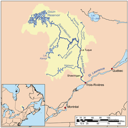
is a freshwater body located in the western part of the
611:
which is located on a peninsula on the north shore of
381:
The main hydrographic slopes near the Male Lake are:
636:
216 kilometres (134 mi) north-west of downtown
663:7.6 kilometres (4.7 mi) easterly crossing the
265:
257:
249:
245:
234:
220:
133:
123:
84:
74:
23:
347:Before the completion of the construction of the
85:
331:South, by the forest road R1009 and the R040.
8:
324:West, by the forest road R1009, serving the
701:where it flows onto the North Shore of the
693:From this dam, the current flows along the
678:, then to the South-East crossing notably
20:
741:
659:, according to the following segments:
510:, the Male Lake stretches northeast to
561:also extends behind this archipelago.
287:, in the administrative region of the
7:
56:
618:78 kilometres (48 mi) west of
283:, in the territory of the town of
14:
730:Commission de toponymie du Québec
480:Plamondon Creek (Gouin Reservoir)
391:Plamondon Creek (Gouin Reservoir)
915:
229:Bourgeois Lake (Gouin Reservoir)
164:The canal of Du Poète Lake (via
55:
48:
29:
719:Plamondon Bay (Gouin Reservoir)
534:. Its main tributaries are the
365:Plamondon Bay (Gouin Reservoir)
264:
256:
248:
189:Plamondon Bay (Gouin Reservoir)
253:36.6 kilometres (22.7 mi)
1:
532:Miller Lake (Gouin Reservoir)
437:Bureau Lake (Gouin Reservoir)
422:Bureau Lake (Gouin Reservoir)
261:14.1 kilometres (8.8 mi)
73:
667:to the south of the village
813:GPX (secondary coordinates)
960:
565:Southwest part of the lake
526:Northeast part of the lake
269:402 metres (1,319 ft)
144:(clockwise from the mouth)
808:GPX (primary coordinates)
783:Map all coordinates using
542:(coming from the North).
43:
28:
791:Download coordinates as:
514:in the northern part of
907:List of lakes in Canada
18:Lake of dam in La Tuque
351:in 1916, creating the
886:De la Rencontre Creek
803:GPX (all coordinates)
647:(confluence with the
540:De la Rencontre Creek
387:De la Rencontre Creek
211:De la Rencontre Creek
108:48.58472°N 75.14000°W
736:Notes and references
629:(north shore of the
147:Flapjack River (via
826:Saint-Maurice River
695:Saint-Maurice River
651:at Trois-Rivières).
645:Saint-Maurice River
631:Saint-Maurice River
488:Adolphe-Poisson Bay
445:Adolphe-Poisson Bay
357:Saint-Maurice River
177:Adolphe-Poisson Bay
166:Piciw Minikanan Bay
159:Adolphe-Poisson Bay
113:48.58472; -75.14000
104: /
37:Saint-Maurice River
703:St. Lawrence River
682:, then across the
649:St. Lawrence River
379:to the Northeast.
371:in the Southwest,
939:Lakes of Mauricie
894:, a body of water
870:, a body of water
864:, a body of water
858:, a body of water
852:, a body of water
846:, a body of water
840:, a body of water
834:, a body of water
669:Obedjiwan, Quebec
609:Obedjiwan, Quebec
551:Obedjiwan, Quebec
375:in the South and
319:Obedjiwan, Quebec
273:
272:
266:Surface elevation
951:
944:La Tuque, Quebec
925:
920:
919:
918:
850:Rocher-Matci Bay
769:
764:
758:
755:
749:
746:
627:Wemotaci, Quebec
430:Rocher-Matci Bay
224:
223:Primary outflows
137:
119:
118:
116:
115:
114:
109:
105:
102:
101:
100:
97:
87:
59:
58:
52:
33:
21:
959:
958:
954:
953:
952:
950:
949:
948:
929:
928:
921:
916:
914:
911:
888:, a watercourse
882:, a watercourse
880:Piponisiw River
876:, a watercourse
874:Plamondon Creek
832:Gouin Reservoir
828:, a watercourse
821:
820:
819:
818:
817:
778:
773:
772:
765:
761:
756:
752:
747:
743:
738:
723:Kaopatinak Pass
711:
706:
613:Gouin Reservoir
583:Adolphe-Poisson
571:Kaopatinak Pass
553:. Southwest of
536:Piponisiw River
520:Kaopatinak Pass
496:Mégiscane River
476:Pascagama River
472:Berthelot River
399:Toussaint River
395:Pascagama River
353:Gouin Reservoir
345:
326:Gouin Reservoir
281:Gouin Reservoir
238: countries
216:
205:Piponisiw River
136:Primary inflows
112:
110:
106:
103:
98:
95:
93:
91:
90:
70:
69:
68:
67:
66:
65:
64:
60:
39:
19:
12:
11:
5:
957:
955:
947:
946:
941:
931:
930:
927:
926:
910:
909:
904:
895:
889:
883:
877:
871:
865:
859:
853:
847:
841:
838:Bourgeois Lake
835:
829:
822:
816:
815:
810:
805:
800:
794:
788:
781:
780:
779:
777:
774:
771:
770:
759:
750:
740:
739:
737:
734:
710:
707:
699:Trois-Rivières
692:
691:
684:Kikendatch Bay
672:
665:Bourgeois Lake
653:
652:
641:
634:
623:
616:
598:Matci Rock Bay
555:Bourgeois Lake
547:Bourgeois Lake
516:Bourgeois Lake
504:
503:
468:
465:Rock-Matci Bay
461:Flapjack River
433:
414:Toussaint Lake
406:Bourgeois Lake
402:
346:
344:
341:
333:
332:
329:
322:
271:
270:
267:
263:
262:
259:
255:
254:
251:
247:
246:
243:
242:
239:
232:
231:
226:
218:
217:
215:
214:
208:
202:
196:
186:
180:
169:
162:
152:
145:
141:
139:
131:
130:
127:
121:
120:
88:
82:
81:
76:
72:
71:
62:
61:
54:
53:
47:
46:
45:
44:
41:
40:
34:
26:
25:
17:
13:
10:
9:
6:
4:
3:
2:
956:
945:
942:
940:
937:
936:
934:
924:
923:Canada portal
913:
908:
905:
903:
899:
896:
893:
890:
887:
884:
881:
878:
875:
872:
869:
868:Plamondon Bay
866:
863:
860:
857:
854:
851:
848:
845:
844:Thibodeau Bay
842:
839:
836:
833:
830:
827:
824:
823:
814:
811:
809:
806:
804:
801:
799:
796:
795:
793:
792:
787:
786:OpenStreetMap
784:
775:
768:
763:
760:
754:
751:
745:
742:
735:
733:
731:
726:
724:
720:
715:
708:
704:
700:
696:
689:
685:
681:
677:
676:Marmette Lake
673:
670:
666:
662:
661:
660:
658:
650:
646:
642:
639:
635:
632:
628:
624:
621:
617:
614:
610:
606:
605:
604:
601:
599:
594:
592:
588:
584:
580:
576:
572:
567:
566:
562:
560:
559:Thibodeau Bay
556:
552:
548:
543:
541:
537:
533:
528:
527:
523:
521:
517:
513:
509:
501:
497:
493:
489:
485:
481:
477:
473:
469:
466:
462:
458:
457:Bignell Creek
454:
450:
446:
442:
439:(South Bay),
438:
434:
431:
427:
424:(North Bay),
423:
419:
418:Marmette Lake
415:
411:
410:Thibodeau Bay
407:
403:
400:
396:
392:
388:
384:
383:
382:
378:
374:
370:
367:in the West,
366:
362:
358:
354:
350:
349:La Loutre Dam
342:
340:
338:
330:
327:
323:
320:
316:
315:
314:
311:
308:
304:
302:
298:
294:
290:
286:
282:
278:
268:
260:
252:
244:
240:
237:
233:
230:
227:
225:
219:
212:
209:
206:
203:
200:
197:
194:
193:Plamondon Bay
190:
187:
184:
181:
178:
174:
170:
167:
163:
160:
156:
155:Bignell Creek
153:
150:
146:
143:
142:
140:
138:
132:
128:
126:
122:
117:
89:
83:
80:
77:
51:
42:
38:
35:Watershed of
32:
27:
22:
16:
790:
789:
782:
762:
753:
744:
727:
716:
712:
654:
602:
595:
568:
564:
563:
544:
529:
525:
524:
505:
500:Mercier Lake
492:Saveney Lake
484:Hanotaux Bay
441:Hanotaux Bay
435:south side:
385:north side:
380:
334:
312:
309:
305:
276:
274:
183:Hanotaux Bay
173:Saveney Lake
63:Du Mâle Lake
24:Du Mâle Lake
15:
892:Aiapew Baie
862:Mattawa Bay
856:Saraana Bay
680:Brochu Lake
579:Mattawa Bay
508:Mattawa Bay
470:west side:
453:Saraana Bay
449:Mattawa Bay
426:Nemio River
404:east side:
373:Saraana Bay
369:Mattawa Bay
250:Max. length
199:Miller Lake
149:Mattawa Bay
129:Lake of dam
111: /
86:Coordinates
933:Categories
512:Aiapew Bay
377:Aiapew Bay
258:Max. width
171:outlet of
99:75°08′24″W
96:48°35′05″N
688:Gouin Dam
657:Gouin Dam
620:Gouin Dam
591:Plamondon
361:Gouin Dam
343:Geography
337:Gouin Dam
291:, in the
277:Male Lake
898:La Tuque
776:See also
709:Toponymy
638:La Tuque
587:Hanotaux
538:and the
293:province
289:Mauricie
285:La Tuque
79:La Tuque
75:Location
686:toward
575:Saraana
301:Canada
297:Quebec
241:Canada
299:, in
236:Basin
191:(via
175:(via
157:(via
902:city
900:, a
721:and
589:and
498:and
275:The
125:Type
798:KML
697:to
295:of
935::
732:.
633:);
593:.
585:,
581:,
577:,
557:,
494:,
490:,
486:,
482:,
478:,
474:,
463:,
459:,
455:,
451:,
447:,
443:,
428:,
420:,
416:,
412:,
408:,
397:,
393:,
389:,
303:.
195:);
179:);
168:);
161:);
151:);
705:.
690:.
671:;
640:;
622:;
615:;
502:.
467:;
432:;
401:;
328:;
321:;
213:.
207:;
201:;
185:;
Text is available under the Creative Commons Attribution-ShareAlike License. Additional terms may apply.